Garrels and McKenzie, 1967; Hem, 1989; Hartman et al., ... 1967; Guiraud, 1973; Vila, 1980) the area of concern is ..... Nice, France. Güler .... Paris VI, France.
Research Journal of Applied Sciences, Engineering and Technology ISSN ©2010 M axwell Scientific Organization
Application of Multivariate Statistical Methods For Characterization of Groundwater - A Case Study: Ain Azel Plain (Algeria) 1
L. Belkhiri, 2 A. Boudoukha and 3 L. Mouni Department of hydraulics, University of Hadj Lakhdar Batna, Algeria, Batna 05000 2 Lab oratoire de recherche en hydraulique ap pliqu ée Université de Hadj Lakhdar B atna, Algeria, Batna 05000 3 Laboratoire de technologie des matériaux et de génie des procédés de l'université de Bejaia, Alegria, Targa- Ouzemour 06000 1
Abstract: Multivariate statistical techniques, cluster and principal component analysis were applied to the data on groundw ater quality of Ain Azel plain (Algeria), to extract principal factors corresponding to the different sources of variation in the hydrochemistry, with the objective of defining the main controls on the hydrochemistry at the plain scale. Q-mode hierarchical clu ster ana lysis grouped 54 gro undwater sam ples into three clusters, i.e., relatively less saline w ater (group 1), mixed water (group 2) an d blended water (group 3), based on the similarity of grou ndw ater quality cha racteristics. Principal compo nent analysis, app lied to the data sets of the three different groups obtained from hierarchical cluster analysis, resulted in four, five and three latent factors explaining 83.21, 83.36 and 87.30% of the total variance in groundwater quality data sets of group 1, group 2 and group 3, respectively. The varifactors obtained from PCA indicate that the parameters respo nsible for grou ndw ater quality variations are mainly related to presence and dissolution of some carbonate, dolom itic and evaporite minerals; natural processes and water-rock interaction in the three water type s. The results of this study clearly dem onstrate the usefulness of m ultivariate statistical an alysis in hydrochemical. Key w ords: Ain Azel plain, A lgeria, clu ster ana lysis, hydrochem istry, princ ipal compo nent analysis INTRODUCTION In the current world economic paradigms, su stainab le socioeconomic development of every community depends much on the sustainability of the available water resources. W ater of adequate quantity and quality is required to meet growing household, industrial and agricultural needs. Groundwater quality is a very sensitive issue, which transcends national boun daries. It is influenced by m any factors, including atm osph eric chemistry, the underlying geology, the vegetation (or organic matter decay), and anthropogenic agents. The solubility of minerals in water places an upper limit on the maximum amounts of certain species of ch emicals in natural waters. Some minerals like carbonates and evaporites dissolve quickly and change the composition of water faster, w hile other minerals like silicates dissolve more slowly and have less conspicuous effects on the composition of water. Tem perature also plays a v ital role in controlling the chemical and biological composition of a freshwater body. Previous studies (Frape et al., 1984; Garrels and McK enzie, 1967; Hem, 1989; Hartman et al., 2005) have revealed that the chem istry of natural waters can often be traced to the reaction of these waters w ith sedim ents or rocks through which they flow. Based on
catchmen ts studies in the USA, Walling (1980) observed differences in the weathering mechanisms of different rocks. W alling (1980) concluded that total dissolved solids in the water from limestones, volcanics and sand and gravel is almost independent of the amou nt of runoff. These differences in behavior accrue from the differences in the solubilities of the minerals present in these rocks (Yidana et al., 2008). Multivariate statistical tech nique s, cluster analysis (CA) and factor analysis (FA), are effective means of manipulating, interpreting and representing data concerning groundw ater pollutants and geoch emistry. They are frequently employed to characterize the quality of groundwater. Liu et al. (2003) adopted F A to evaluate groundwater quality in a blackfoot disease area, Taiwan. Two factors, seaw ater salinization and arsenic pollutant, were considered and their factor scores were mapped. Love et al. (2004) applied FA to distinguish several groundwater signatures, including uncontaminated ground water, agricultural activities, mining activities and sewage pollution. Olmez et al. (1994), Mahlkn echt et al. (2003) and Farnham et al. (2003) used FA to discuss geochemical evolution and mineralization and groundwater contamination. Additionally, the CA was also used to interpret the hydrochemical data based on
Corresponding Author: L. Belkhiri, Department of hydraulics, University of Hadj Lakhdar Batna, Batna 05000 Algeria 1
Research Journal of Applied Sciences, Engineering and Technology
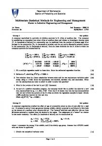
Fig. 1: Map showing water sampling locations and geology of the studied area factor scores, see, for example, Suk and Lee (1999), Reghunath et al. (2002) and Kim et al. (2005). This study com prises application of m ultivariate statistical techniques to groundwater quality data set obtained from groundwater of Ain Azel plain in Algeria.
According to many authors (Savornin, 1920; Galcon, 1967; Guiraud, 1973; Vila, 1980) the area of concern is distinguished by two geological sets. In the South, autochthonous Jurassic and Cretaceou s carbonate lithologies are mainly observed in Djebels Boutaleb, Djebel Hadjar Labiod an d Fourh al (Fig. 1). In the North, allochthonous Jurassic and Cretaceo us lithologies are observed in Dje bels K alaoun and Sek rine. A lithostratigraphic study of Ain Azel area identifies the following two aquifer formations. The first is a carbonate and sandy form ation of abou t 700 m thick presenting fracture porosity and constitutes the Barremian formation. The second is an alluvial formation of about 250 m thick corresponding to a Mio-Plio-Quaternary form ation w ith interstitial porosity (Boutaleb, 2001; Belkhiri, 2005). A mineralogical study shows that the metalliferous minerals, particularly the sphalerite, the gangue minerals and the
Study area: The studied area is located in the east of Algeria. Most of inhabitants (more than 30000 inhabitants) are centered on the town of Ain Azel. The principal activity in this area is the production of cereals (barley and corn) an d its climate is semi-arid. The amount of rainfall varies from place to place and fro m season to season, ranging from 346 m m/yr in the plains (altitude < 1000 m) to 534 mm/yr in the mountains (altitude > 1000 m). The annual maximum and minimum temperatures are 21.8 and 8.5ºC , respectively (Belk hiri, 2005).
2
Research Journal of Applied Sciences, Engineering and Technology
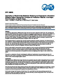
Fig. 2: Potentiometric surface map in December, 2004 (unit: m) dolomite contain variable quantities of trace metals such as Zn, Pb , Cd, Fe an d Cu (Boutaleb, 2001). The studied area is situated in the alluvial plain of the Mio-Plio-Quaternary (Fig. 1) showing a heterogeneous continental detrital sedimentation (Boutaleb, 2001; Belkhiri, 2005; A ttoucheik, 200 6). This aquifer is directly fed by stream water coming from different reliefs surrounding the depression inter-mountainou s of A in Azel. The plain hosts a large num ber of w ater-w ells with depths varying from 8 to 38 m. M ost of the se w ells supply water for drinking and irrigation. The direction of groundwater flow aroun d Ain Azel plain is from south to north and from west to east. In general, the groundwater flows toward center of the plain (Fig. 2) and development this map shows a piezometric depression, which coincides with high density of the well in the center of the plain. The limits of south and west are of imposed entering flux; however the limit of east is of null flux. The pumping tests on different wells showed high transmissivity (30-36 m 2 /day) indicating high yields (Belkhiri, 2005 ).
Groundwater samplings were performed three time s in 2004: June, September, and December and a total of 54 groundwater samples were collected during this period. The samples were collected after pumping for 10 min. This was don e to remove groundw ater store d in the well. These samples were collected using 4-1 acid-washed polypropylene containers. Each samp le wa s imm ediately filtered on site through 0.45 :m filters on acetate cellulose. Filtrate for metals analyses were transferred into 100-cm 3 polye thylene bottles and im med iately acidified to pH < 2 by the addition of MerckT M ultrapure nitric acid (5 ml 6N HNO 3). Samples for anions analyses were collected into 250-cm3 polyethylene bottles without preservation. All the samples were stored in an ice chest at a temperatu re of K and all samples exceeded the desirable limit of Ca for drinking water (75 mg/l) except sample 10, but only 78% of them exceed that of Mg (50 mg/l). The abundance of the major anions is HCO 3 $ Cl > SO 4 and almost 28 % of the samp les exc eede d the desirable limit of Cl (200 mg/l), but the sulfate concentrations are all below health guidelines (W HO, 1993). The concentration of lead for the three campaigns ranges from 0.02 to 1.83 mg/l and all samples exceeded the WHO guideline limit of 0.01 m g/l. In the case of iron, the con centration in many of the samples was higher than the WHO permitted limit of 0.3 mg/l and the percent samples above the WHO limit ranges from 60 to 83 % for the three campaigns. Since in this region, except for agricultural activity no other anthro pogenic activities were being carried out in this region and h ence the high Fe conc entration in these waters could not be assigned to the an thropogenic activities but rather the water-rock interaction should be the reason for the higher value of Fe observed in the plain. It is clearly observed that the concentrations of the major elements do not undergo an appreciable change during the three campaigns. For this reason the three campaigns were grouped as one.
Factor analysis: The Kaiser criterion (Kaiser, 1960) was applied to determine the total number of factors for each dataset in this analysis. Under this criterion, only factors with eigenvalues greater than or equal to 1 will be accepted as possible sources of variance in the data, with
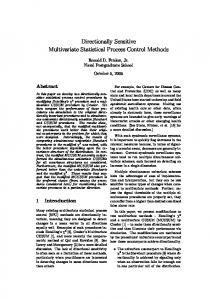
Cluster analysis: Cluster analysis suggests three groups of groundwater’s (Fig. 3; Table 2). EC seems to be a major distinguishing factor, which increases with 5
Research Journal of Applied Sciences, Engineering and Technology Tab le 3: Ro tation P CA loadin g m atrix Group 1 2 ------------------------------------------------------------------------------------------------------------------Component 1 2 3 4 1 2 3 4 5 EC 0.92 0.22 -0.18 0.06 0.20 -0.09 -0.02 0.92 -0.14 pH -0.16 -0.28 0.37 0.78 0.80 0.21 -0.22 0.14 0.07 Ca 0.81 0.05 0.02 -0.27 -0.86 0.25 0.01 0.11 0.21 Mg 0.81 0.26 0.12 -0.28 0.13 0.87 0.20 0.05 0.03 Na 0.34 -0.82 0.06 0.26 -0.28 0.37 -0.59 0.37 0.43 K 0.23 -0.26 -0.46 0.63 0.05 -0.14 0.07 -0.14 0.93 Cl 0.88 -0.38 -0.07 0.06 0.78 0.27 0.07 0.36 0.25 SO4 -0.47 0.06 -0.15 0.77 0.05 0.14 0.94 -0.04 0.07 HCO3 0.40 0.78 0.00 -0.36 -0.40 0.07 0.84 0.09 0.06 Pb -0.01 0.09 0.89 0.00 0.35 0.74 -0.02 -0.35 0.05 Fe 0.23 0.78 0.36 0.13 -0.16 0.72 -0.04 0.05 -0.16 % of variance 32.32 20.86 12.24 17.80 22.13 19.93 18.47 11.80 11.02 Cum ulative % 32.32 53.17 65.41 83.21 22.13 42.06 60.54 72.34 83.36 The bold values indicate absolute component loadings higher than 0.5, which are considered significant contributors to the variance
3 ------------------------------------------1 2 3 -0.13 0.69 0.62 -0.96 -0.07 -0.07 0.44 0.84 -0.15 0.68 0.62 0.10 0.93 0.29 -0.07 0.24 -0.93 -0.04 0.93 0.18 -0.20 0.91 -0.35 -0.06 -0.91 0.05 0.32 -0.66 0.05 -0.23 0.00 -0.02 0.91 49.72 24.45 13.14 49.72 74.17 87.30 in the hydrochemistry.
Fig. 3: Dendrogram of the hydrochemical samples the highest priority ascribed to the factor that has the highest eigenvecto r sum. The rationale for choosing 1 is that a factor must have a variance at least as large as that of a single standardized origin al variable to be acceptable.
1960). An initial run using the Kaiser criterion (Kaiser, 1960) resulted in five principal co mpo nents. However, it was observed that the fifth factor would not constitute a unique source of variance in the hydrochemistry since it had only o ne loading greater than 0.50 . It was therefore dropped and fo ur factors we re cho sen for varimax rotation. The results (Table 3) show that the four PC
Group 1: Four principal com ponen ts (PC) w ere extracted and rotated using the varimax no rmalization (K aiser, 6
Research Journal of Applied Sciences, Engineering and Technology account for more than 83.21% percent of the total variance, which is qu ite good and can be relied upon to identify the main sources of variation in the hydrochemistry. PC1 represents about 32.32% of the variance and has high absolute loadings fo r E C, C a, M g and Cl and p robably shows the result of mineral water reactions in the area. PC 2, which accounts for 20.86% of the total variance, contains h igh loadings for Na, HCO 3 and Fe. PC1and PC2 represents the major geochemical processes taking place, which is most probably the presence and d issolution of some carbonate, dolom itic and eva porite minerals in the aq uifer. PC3 and PC4, respectively, show high loadings for Pb and pH, K and SO 4 . PC3 and PC4, which, respectively, account for 12.24% and 17.80% of the variation in the hydrochemistry.
plain, Algeria. Interpretation of analytical data showed that the abundance of the major ions is as follows: Ca $ M g > Na > K and HCO 3 $ Cl > SO 4 . Three major water types are suggested by the Q-mode HCA analysis. The samples from the area were classified as less saline water (Ca-Mg-HCO 3 ), mixed water (Mg-Ca-HCO 3 -Cl) and blended water (Mg-Ca-Cl-HCO 3 ). The varifactors obtained from PC A indicate that the parame ters respo nsible for groundwater quality variations are mainly related to presence and dissolution of some carbonate, dolomitic and evaporite minerals in relatively less saline water type; natural processes and water-rock interaction in mixed water type; water-rock interaction in blended water type. The results of this study clearly dem onstrate the usefulness o f multivariate statistical ana lysis in hydrochemical.
Group 2: Five significant PCs explain 83.36% of the total variation in the hydrochem istry. M ost of the variance is contained in the PC1 (22.13%), which is associated with the variables pH, Ca and Cl (Table 3). PC 2 represents 19.93% of the total variation in the hydrochemistry and has high loading s for M g, Pb and Fe. The variables Na, HCO 3 and SO 4 contribute mo st strongly to the third component (PC3) that explains 18.47% of the total variance. PC1, PC2 and PC3 are assumed to be indicative of the natural processes and water-rock interaction. PC4 and PC5, respectively, show high loadings for EC and K.
ACKNOWLEDGMENT The autho rs thank the technician A bdelkarim Zebila for laboratory of the hydrochemistry, earth science institutes, University of Constantine, Algeria. REFERENCES Alberto, W .D., D.M. Del Pilar, A.M. Valeria, P.S. Fabiana, H.A. Cecilia and B.M . De Los A ngeles, 2001. Pattern recognition techniques for the evaluation of spatial and temporal variations in water quality. A case study: Suqu2a Rive r Basin (CordobaArgentina). Water Res., 35: 2881-2894. Alther, G.A ., 1979 . A sim plified statistical sequence applied to routine water quality analysis: a case history. Ground Water, 17: 556-561. Anazawa, K. and H . Ohmori, 2005. The hydrochem istry of surface waters in Andesitic Volcanic area, Noriku ra volcano, central Japan. Chemosphere, 59: 605-615. Anazawa, K., H. Ohmori, T. Tomiyasu and M. Sakamoto, 2003. Hydrochem istry at a volcan ic summit area, N o r i k u ra , c e n t r a l J a p a n . G e o c h i m ic a et Cosmochimica Acta., 67(18S): 17. APHA (American Pub lic Health A ssociation), 1989. Standard Methods for Examination of Water and W astewater. 17th Edn., American Public Health Association, Washington, DC, pp: 1470. APHA (American Public Health Association), AWWA (American W ater W orks A ssociation), and WPCF (Water Pollution Control Federation), 1995a. Standard Methods for the Examination of Water and W aste Water. 19th Edn., New York, USA, pp: 2000. APHA (Am erican Public Health Association), 1995b. Standard Methods for the Examination of Water and W astewater. 19th E dn., A merican Public H ealth Association, Washington, DC, pp: 1467.
Group 3: Three PCs explain 87.30% of the total variance (Table 3). Most of the variance is contained in the PC1 (49.72% ), which is associated with the variables pH, Mg, Na, Cl, SO 4 , HCO 3 and Pb and probably shows the resu lt of mineral water reactions in the plain. The aq uifer is sedimen tary rocks, which range from sandstones to conglomerates to clays with varying mineralogical compositions. The variables EC, Ca and K contribute most strongly to the third component (PC2), which explains 24.45 % o f the total variance and probably represents the presence of carbonate minerals in the aquifer. PC3 explains 13.14% of the varian ce and is mainly related to Fe and assumed to be indicative of the water-rock interaction. CONCLUSION Multivariate statistical techniques including cluster and principal component analysis can successfully be used to derive information from the data set about the possible influences of the environment on groundwater quality and also identify natural groupings in the set of data. These methods are important to avoid misinterpretation of environmental monitoring data due to uncertainties. In this study, multivariate statistical methods were app lied to data set obtained from Ain Azel 7
Research Journal of Applied Sciences, Engineering and Technology Attoucheik, L., 2006. Geochemical study of the rejections of the mining complex of Kherzet Youssef (SETIF) and its environmental impact. Thesis, IST. USTHB, Algeria. Belkhiri, L., 2005. Hydrogeologicl study and the problem of groundwater quality in the Ain Azel plain, Setif, eastern Algeria. Thesis, University of Batna, Algeria. Boutaleb, A., 2001. The Pb-Zn mineralization in the Setif-Hodna: Me tallogeny, petrography of dolomites, microtherm ometry and metallogenic implications. Ph.D. Thesis, Statement in Mining Geology, IST. USTH B, Algeria. Brown, C.E., 1998 . Applied M ultivariate Statistics in Geohydrology and Related S ciences. Sp ringer, New York Cameron, E.M., 1996. The hydrochemistry of the Fraser River, British Columbia: seasonal variation in major and minor components. J. Hydrol., 182: 209-215. Clesceri, L.S., A.E. Greenberg and A.D. Eaton, 1998. Standard Methods for the Examination of Water and W astewater. 20th Edn ., Am erican Public Health Association, American Water Works Association, W ater Environment Federation, Washington. Duffy, C.J. and D . Brandes, 2001. D imension reduction and source identification for multispecie s groundwater contamination. J. Contam . Hydrol., 48: 151-165. Farnham, I.M., K.H. Johannesson, A.K. Singh, V.F. Hodge and K.J. Stetzenbach, 2003. Factor analytical approaches for evaluating groundwater trace element chem istry data. A nal. Chimica Acta., 490(1-2): 123138. Farnham, I.M., K.J. Stetzenbach, A.K. Singh and K.H. Johannesson, 2000. D eciphering g roundw ater flow systems in Oa sis Valley, Nevada, using trace element chemistry, multivariate statistics and geographical information system. Math. Geol., 32: 943-968. Frape, S.K., P. Fritz and R.H. McNutt, 1984. Water-rock interaction and chemistry of groundwaters from the Canadian Shield . Geo chim . Cosmochim. Acta., 48: 1617-1627. Galcon, J., 1967. Research on the geology and m etallic heeled in the Setif Tell. Doct Thesis, Sc. N at. Publ. Serv. Geol. From Algeria. Garrels, R.M. and F.T. MacKenzie, 1967. Origin of the Chemical Compositions of Some Springs and Lakes. In: Equilibrium Concepts in Natural Waters. American Cancer Society, Washington, DC. Guiraud, R., 1973. Post-Triassic evolution of the foreland of the Alpine chain of Algeria, according to the study of El Eulma Basin and surrounding areas, Thesis Sc. Nat. Nice, France. Güler, C. and G .D. Thyne, 200 4. Hydrologic and g eolog ic factors controlling surface and Groundwater chem istry in Indian wells-Owens V alley area, southeastern California, USA. J. Hydrol., 285: 177198.
Güler, C., G.D . Thyne, J.E. McCray an d A.K . Turner, 2002. Evaluation of grap hical an d mu ltivariate statistical methods fo r classification of water chemistry data. Hydrogeol. J., 10: 455-474. Gupta, L.P., an d V. Subrama nian, 1998. Geochemical factors controlling the chemical nature of water and sedim ents in the Gomte River, India. Environ. G eol., 36: 102-108. Hartman, J., Z. Berna, D. Stuben an d N. Hen ze, 2005. A statistical procedure for the analysis of seism otech tonically induced hydrochemical signals: A case study from the Ea stern Carpathians, Romania. Tectonophysics, 405: 77-98. Hem, J.D., 1989. Study and interpretation of the chemical chara cteristics of natural water. US Geol. Surv. W ater Supply Pap., 2254. Huisman, D.J. and P. Kiden, 1998. A geo chem ical record of late Cenozoic se dimentation history in southern Netherlands. Geologie en Mijnbouw., 76: 277-292. Kaiser, H.F., 1960. The application of electronic comp uters to factor analysis. Educ. Psychol. M eas., 20: 141-151. Kim, J.H., R .H. K im, J.H . Lee, T.J. Cheong, B.W. Yum and H.W . Cha ng, 20 05. M ultivariate statistical analysis to identify the major factors governing groundwater quality in the coastal area of Kimje, South Korea. Hydrol. Process., 19(6): 1261-1276. Laaksoharju, M., I. Gurban, C. Skarman and E. Skarman, 1999. Multivariate mixing and mass balance (M3) c a l c u l a t i o n s , a n e w t o o l f o r d e c o di n g hydrogeochemical information. Appl. Geochem., 14: 861-871. Liu, C.W., K.H. Lin and Y.M. Kuo, 2003. Application of factor analysis in the assessment of groundwater quality in a blackfoot disease area in Ta iwan. Sc i. Total Environ., 313: 77-89. Love, D., D. H allbauer, A. Amos and R. Hranova, 2004. Factor analysis as a tool in groundwater quality man agem ent: two southern African case studies. Phys. Chem. Earth., 29(15-18): 1135-1143. Mahlkn echt, J., B. Steinich and I. Navarro de Leon, 2003. Groundwater chemistry and mass transfers in the Independence aquifer. Central Mexico, by using multivariate statistics and mass-balance models. Meng, S.X. and J.B. M aynard, 2001. Use of statistical analy sis to formulate conceptual models of geochemical behavior: water chemical data from Butucatu aquifer in Sao Paulo State, Brazil. J. Hydrol., 250: 78-97. Mom en, B., L.W. Eichler, C.W . Boylen and J.P. Zehr, 1996. Application of mu ltivariate statistics in detecting temporal and spatial patterns of water chem istry in Lak e George, Ne w Y ork. Ecol. Model., 91: 183-192. 8
Research Journal of Applied Sciences, Engineering and Technology Olmez, I., J.W. Beal and J.F. Villaume, 1994. New approach to understanding m ultiple -sourc e groundwater contamination: factor analysis and chemical mass balances. Water Res., 28(5): 10951101. Reghunath, R., T.R.S. Murthy and B.R. Raghavan, 2002. The utility of multivariate statistical techniqu es in hydrogeochemical studies: An example from Karnataka, India. Water Res., 36(10): 2437-2442. Savornin, J., 1920. Geolog ical surv ey ho dna and shelf Sétif. Thèse Sc. Nat. Lyon. France. STATISTICA® 5.0 for Windows., 1998. StatSoft, Inc., Tulsa OK. USDA, Natural Resources Conservation Services, 1999. Soil taxonomy: A basic system of soil classifica tion for m aking and interpreting soil surveys. Agriculture Handbook No. 436, pp: 871. Suk, H.J. and K .K. Lee, 1999. Characterization of a ground water hydrochemical system through multivariate analysis: clustering into ground water zones. Ground Water, 37(3): 358-366. Tariq, R.S., M.H. Shah, N. Shaheen, K. Khalique, S. Manzoor and M. Jaffar, 20 05. M ultivariate analysis of trace m etal leve ls in tannery effluents in re lation to soil and water: a case study from Peshaw ar, Pakistan. J. Environ. Mange., 79: 20-29. Tebens, L., A. Veldkamp and S.B. Kroonenberg, 2001. The impact of climate change on the bulk and clay geochemistry of fluvial residual channel infillings: The Late Weichselian and Early Holocene River Meuse sedimen ts (The N etherlands). J. Qu aternary Sci., 13: 345-356.
Vila, J.M ., 1980 . The A lpine C hain o f Eastern Algeria and the Algerian-Tunisian border, Thesis of docto rate be-Sc. Nat. Paris VI, France. W alling, D.E., 1980. Water in Catchment Ecosystems. In: Gow er, A.M . (Ed.), Geochemistry, Groundwater and Pollution. A.A. Balkema, Rotterdam. W ard, J.H., 1963. Hierarchical group ing to optimize an objective function. J. Am. Stat. Assoc., 69: 236-244. WHO (World Health Organization), 1993. Guidelines for Drinking W ater Q uality. V ol. 1, Recomm endations, 2nd Edn., Geneva, W HO, pp: 130. W illiams, R.E., 1982. Statistical identification of hydraulic connections between the surface of a mou ntain and internal mineralized sources. Ground W ater, 20: 466-478. Yidanaa, S.M ., D. Ophoria and B. Banoeng-Yakubob, 2008. A multivariate statistical analysis of surface water chemistry data-The Ankobra B asin, Ghana. J. Environ. Mange., 88: 697-707. Zeng, X. an d C.D. R asmussen, 200 5. M ultivariate statistical characterization of w ater quality in Lake Lanier, Geo rgia, USA. J. Environ. Qual., 34: 19801991.
9