McMahon, Nicole D., "Automation of shear-wave splitting parameter ...... Snake River plain volcano-tectonic system; campaign and continuous GPS observations ...
Michigan Technological University
Digital Commons @ Michigan Tech Dissertations, Master's Theses and Master's Reports Dissertations, Master's Theses and Master's Reports - Open 2011
Automation of shear-wave splitting parameter determination of local earthquakes at Yellowstone : application as indicator of crustal stress and temporal variation Nicole D. McMahon Michigan Technological University
Copyright 2011 Nicole D. McMahon Recommended Citation McMahon, Nicole D., "Automation of shear-wave splitting parameter determination of local earthquakes at Yellowstone : application as indicator of crustal stress and temporal variation ", Master's Thesis, Michigan Technological University, 2011. http://digitalcommons.mtu.edu/etds/333
Follow this and additional works at: http://digitalcommons.mtu.edu/etds Part of the Geophysics and Seismology Commons
AUTOMATION OF SHEAR-WAVE SPLITTING PARAMETER DETERMINATION OF LOCAL EARTHQUAKES AT YELLOWSTONE: APPLICATION AS INDICATOR OF CRUSTAL STRESS AND TEMPORAL VARIATION
By Nicole D. McMahon
A THESIS Submitted in partial fulfillment of the requirements for the degree of MASTER OF SCIENCE (Geophysics)
MICHIGAN TECHNOLOGICAL UNIVERSITY 2011
© 2011 Nicole D. McMahon
This thesis, “Automation of shear-wave splitting parameter determination of local earthquakes at Yellowstone: Application as indicator of crustal stress and temporal variation,” is hereby approved in partial fulfillment of the requirements for the Degree of MASTER OF SCIENCE IN GEOPHYSICS.
Department of Geological and Mining Engineering and Sciences
Signatures: Thesis Advisor
_____________________________________________ Dr. Gregory P. Waite
Committee Member
_____________________________________________ Dr. Simon A. Carn
Committee Member
_____________________________________________ Dr. Petra Huentemeyer
Department Chair
_____________________________________________ Dr. Wayne D. Pennington
Date
_____________________________________________
Table of Contents List of Figures ..................................................................................................................... 4 List of Tables ...................................................................................................................... 5 Abstract ............................................................................................................................... 6 1. Introduction ................................................................................................................. 7 1.1. Geologic Setting ................................................................................................... 8 1.2. Yellowstone Seismicity ...................................................................................... 10 1.3. Yellowstone Deformation .................................................................................. 11 1.4. Shear-wave Splitting .......................................................................................... 13 2. Data ............................................................................................................................ 15 3. Methodology.............................................................................................................. 18 3.1. Shear-wave Splitting Parameter Calculations .................................................... 18 3.2. The Analysis Window ........................................................................................ 19 3.3. Cluster Analysis ................................................................................................. 20 3.4. Cycle Skipping ................................................................................................... 21 4. Results ....................................................................................................................... 25 4.1. The Silver and Chan (1991) Method .................................................................. 25 4.2. The Levin et al. (1999) Method ......................................................................... 32 5. Discussion.................................................................................................................. 38 5.1. Comparisons to the Local Stress Field ............................................................... 38 5.2. Temporal Variation in Fast Directions ............................................................... 41 5.3. Fast Directions vs. Back Azimuth ...................................................................... 46 5.4. Fast Directions vs. Frequency Band ................................................................... 47 5.5. Calculating Anisotropy ...................................................................................... 50 6. Conclusions ............................................................................................................... 57 7. Reference List ............................................................................................................ 59 8. Appendix A: Cluster Analysis Details....................................................................... 64 8.1. Clustering ........................................................................................................... 64 8.2. Selecting the Optimum Number of Clusters ...................................................... 65 8.3. Selecting the Optimum Cluster and Measurement ............................................. 68 9. Appendix B: Figure 1.2 Copyright License Agreement ............................................ 70
3
List of Figures Figure 1.1 Figure 1.2 Figure 1.3 Figure 2.1 Figure 3.1 Figure 4.1 Figure 4.2 Figure 4.3 Figure 4.4 Figure 4.5 Figure 4.6 Figure 4.7 Figure 4.8 Figure 4.9 Figure 4.10 Figure 5.1 Figure 5.2 Figure 5.3 Figure 5.4 Figure 5.5 Figure 5.6 Figure 5.7 Figure 5.8 Figure 5.9 Figure 5.10
Map of the Yellowstone and Eastern Snake River Plain volcanic system .......................................................................................9 Deformation details of the Yellowstone volcanic field .............................12 Diagrams of shear-wave splitting terminology ..........................................14 Earthquake and station location map .........................................................17 Visible effects of cycle skipping ................................................................22 Silver and Chan (1991) shear-wave splits map..........................................26 Rose plots of Silver and Chan (1991) fast polarization directions ............27 Event diagnostic example 1 .......................................................................28 Event diagnostic example 1 – corrected for cycle skipping ......................29 Event diagnostic example 2 .......................................................................30 Event diagnostic example 2 – corrected for cycle skipping ......................31 SC shear-wave splits map – corrected for cycle skipping .........................34 Rose plots of Silver and Chan (1991) fast polarization directions – corrected for cycle skipping ..................................................................35 Rose plots of Levin et al. (1999) fast directions ........................................36 Rose plots of Levin et al. (1999) fast directions – corrected for cycle skipping .......................................................................................37 Map of preferred fast directions, local stress and strain ............................39 Schematic of crack induced anisotropy .....................................................40 Fast direction as a function of time ............................................................43 Fast direction vs. 60-day and 180-day average on station YHH ...............44 Fast direction by year at station YHH........................................................45 Fast direction as a function of back azimuth .............................................48 Fast direction vs. 10° back azimuth average on stations YHH and YMR .....................................................................................49 Fast direction vs. frequency band: B208, H17A, LKWY ..........................51 Fast direction vs. frequency band: YFT, YHH, YJC .................................52 Fast direction vs. frequency band: YMP, YMR, YNR ..............................53
4
List of Tables Table 2.1 Table 3.1 Table 3.2 Table 5.1 Table 5.2 Table 8.1
Seismic station information .......................................................................16 Time window analysis and grid search parameters ...................................21 Cluster analysis and cycle skipping parameters.........................................23 Interpreted general fast directions vs. σ3 and εmax .....................................40 Calculated percent anisotropies and crack densities ..................................56 Cluster analysis parameters........................................................................69
5
Abstract Shear-wave splitting can be a useful technique for determining crustal stress fields in volcanic settings and temporal variations associated with activity. Splitting parameters were determined for a subset of local earthquakes recorded from 2000-2010 at Yellowstone. Analysis was automated using an unsupervised cluster analysis technique to determine optimum splitting parameters from 270 analysis windows for each event. Six stations clearly exhibit preferential fast polarization values sub-orthogonal to the direction of minimum horizontal compression. Yellowstone deformation results in a local crustal stress field differing from the regional field dominated by NE-SW extension, and fast directions reflect this difference rotating around the caldera maintaining perpendicularity to the rim. One station exhibits temporal variations concordant with identified periods of caldera subsidence and uplift. From splitting measurements, we calculated a crustal anisotropy of ~17-23% and crack density ~0.12-0.17 possibly resulting from stress-aligned fluid filled microcracks in the upper crust and an active hydrothermal system.
6
Acknowledgements I would like to thank my advisor Greg Waite for the tremendous amount of assistance and encouragement offered in the course of my research. Thanks to Simon Carn and Petra Huentemeyer for sitting on my committee, offering non-seismologists’ points of view, and editorial suggestions. The earthquake catalog was obtained from the University of Utah, Salt Lake City, UT, and the MATLAB codes for determining shearwave splitting parameters were written by Derek Schutt and Greg Waite.
7
1. Introduction Shear-wave splitting is frequently used to measure anisotropy in the Earth and describe its structure. Shear-wave splitting parameters can be used to describe the medium through which seismic waves have passed. Several techniques for determining these splitting parameters have been developed (e.g., Silver and Chan 1991; Levin et al. 1999; Long and van der Hilst 2005). We apply a semi-automated shear wave measurement technique to local earthquakes in the Yellowstone region in order to determine the direction of crustal stresses as well as define temporal variations related to the deformation of the caldera. By automating determination of shear-wave splitting parameters we dramatically increase the practicality of incorporating large amounts of earthquake data into our study and hopefully improve the quality of results.
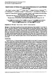
1.1. Geologic Setting The Yellowstone volcanic system is one of the largest and most active silicic volcanic systems in the world. The Yellowstone Plateau is the youngest in a 16 Ma series of progressively older volcanic centers defined by a hotspot track extending 800-km southwest along the eastern Snake River Plain to the Oregon-Nevada border (Figure 1.1) (Christiansen 2001; Waite et al. 2005). More than 140 giant silicic eruptions have been identified associated with the hotspot’s eastward track (Perkins and Nash 2002). Three cataclysmic eruptions at 2.05, 1.3, and 0.64 Ma formed the presently active 40-km by 70-km caldera and Yellowstone Plateau volcanic field (Christiansen 2001). The most recent eruption at 70 ka is one of more than 50 rhyolite flows occurring since the caldera formation (Christiansen 2001; Christiansen et al. 2007). Geodetic data reveal that Yellowstone deformation is dominated by the lithospheric extension of the Basin and Range province and the superposition of caldera subsidence and uplift (Smith et al. 2009). Gripp and Gordon (2002) observed the North American Plate at Yellowstone to be moving at an azimuth of 241°, and Smith et al. (2009) 8
Figure 1.1 Map of the Yellowstone and Eastern Snake River Plain volcanic system. State boundaries are solid black lines. Earthquake epicenters are plotted as black circles. Eruptive centers are white dashed ellipsoids with age in Ma. Apparent plate notion (APM) of 241° from Gripp and Gordon (2002) is indicated by the white arrow. The area of study is indicated by the red box. There is a topographic and seismic activity high in a parabolic pattern around the Easter Snake River Plain with its apex at Yellowstone. Waite GP, Smith RB, Allen RM. 2006. VP and VS structure of the Yellowstone hot spot from teleseismic tomography: Evidence for an upper mantle plume. Journal of Geophysical Research, 111( B04303), 2006. Copyright 2006 American Geophysical Union. Reproduced/modified by permission of American Geophysical Union.
determined a southwest extension at the rate of 2-3 mm/yr across the Yellowstone Plateau. This rate of extension is approximately one-fourth of the total Basin and Range opening-rate (Smith et al. 2009). Crystallizing magma at shallow depths is responsible for the unusually high heat flow in Yellowstone estimated at ~2000mW/m2 (combined conductive and convective heat), 3040 times the average continental heat flow (Blackwell 1969; Fournier 1989). 9
1.2. Yellowstone Seismicity Yellowstone is the most seismically active area of the 1,300-km long Intermountain Seismic Belt (ISB) extending from Montana to Arizona (Smith and Arabasz 1991). The seismicity in Yellowstone is the result of the interactions between the extending lithosphere of the Basin and Range Province and the Yellowstone volcanic system which can perturb stresses up to 50-km from the hotspot track (Husen and Smith 2004; White et al. 2009). The earthquake activity in Yellowstone is characterized by a low level of background seismicity (< 100 earthquakes/per week) interrupted by infrequent spatially and temporally constrained swarms of small shallow earthquakes (Farrell et al. 2009; Farrell et al. 2010). More than 80 swarms have been identified between since 1995 (Farrell et al. 2009). The largest recorded earthquake swarm in Yellowstone occurred on the northwest rim of the caldera in late 1985 and spanned more than three months with more than 3,000 events of M