CHANGES IN FOREST COMPOSITION AND POTENTIAL FEEDING TREE AVAILABILITY ON A SMALL LAND-BRIDGE ISLAND IN LAGO GURI, VENEZUELA Marilyn A. Norconk and Brian W. Grafton* 1. INTRODUCTION Fragmentation of tropical forests affects the viability of primate populations worldwide. A recent assessment of habitat loss in Latin America has estimated that 9.7% of extant forest was lost between 1980 and 1995 (Chapman and Peres, 2001). Forest fragmentation has many causes (e.g., human encroachment for settlements, agricultural practices, logging, and flooding, Alvarez et al., 1986; Cosson et al., 1999; Chapman and Peres, 2001), but these causes share a common phenomenon. Disruption of contiguous forest creates disjunct patches of forest separated by different types of land use, vegetation, or water, in the case of flooding (Alvarez et al., 1986; Saunders et al., 1991; Terborgh et al., 1997; Cosson et al., 1999). Forest remnants are both smaller, when compared to contiguous forest, and isolated from other forest patches (Saunders et al., 1991). The nature of the surrounding modified habitats—or matrix—imposes a variety of novel (and often detrimental) effects on the plant and animal species still residing within a given fragment (Cosson et al., 1999). In the case of land-bridge islands, water as a barrier has a powerful effect, both in terms of limiting dispersal of resident species and providing an unusable habitat for those species (Turner, 1996; Terborgh et al., 1997; Cosson et al., 1999). Whatever the barrier, fragmentation causes an ‘ecological disruption’ because of a combination of edge effects, and fragment size, shape, and location (Saunders et al., 1991). Interactions between the forest interior and the adjacent habitat along the edge include abiotic effects (changes in such environmental conditions as air temperature, humidity, light intensity), direct biological effects (changes in species distribution and abundance due to the modifications of environmental conditions), and indirect biological
*
Marilyn A. Norconk and Brian W. Grafton at the Department of Anthropology and Biological Anthropology Program, School of Biomedical Sciences, Kent State University, Kent, Ohio, 44242. Correspondence to M. A. Norconk (email:
[email protected]).
2
NORCONK AND GRAFTON
effects (higher-order changes resulting from alterations in species interactions) (Murcia, 1995; Turton and Freiburger, 1997; Sizer and Tanner, 1999). Studies of forest fragments have resulted in the discovery of a variety of problems associated with microhabitat changes. For example, increases in windthrow and ambient temperature, as well as reduced humidity near fragment boundaries, result in a sharp increase in tree mortality, tree damage, and the formation of canopy gaps. Such changes can bring about an increase in plant species adapted to gap and disturbed habitats, resulting in an associated decrease in old-growth canopy trees (Lovejoy et al., 1986; Kapos, 1989; Leigh et al., 1993; Kapos et al., 1997; Laurance et al., 1998a; Mesquita et al., 1999). Turner (1996) found that alterations in microclimate may limit the usefulness of the forest to residents, further reducing the size of the useable area and causing both an increase in forest plant mortality rates and a reduction in their recruitment near the edge. The fact that a species is present in a forest fragment immediately after its isolation does not ensure that it will continue to persist; successful reproduction and recruitment are required (Saunders et al., 1991). A lack of required pollinators and seed dispersers for some plant species can seriously affect the future reproduction of those species and can have far-reaching effects for the future integrity of a given forest fragment (Howe, 1984; Powell and Powell, 1987; Pannel, 1989; Turner, 1996).
2. PRIMATES IN FOREST FRAGMENTS How do primates respond to habitat fragmentation? Two major characteristics of primates—home range size and the degree of frugivory in the diet of a species— influence the ability of different species to live in forest fragments (Tutin and White, 1999; Onderdonk and Chapman, 2000; Estrada and Coates-Estrada, 1996; Lovejoy et al., 1986). The interaction between fragment size, home range size, and diet type is complex; the limited area resulting from fragmentation reduces the diversity of plant species and the number of food plants available to consumers (Tutin and White, 1999). Fruit as a resource is highly heterogeneous in terms of its spatial and temporal distribution, and larger frugivorous primates usually require large tracts of forest to provide enough resources to support viable populations (Johns and Skorupa, 1987; Turner, 1996; Onderdonk and Chapman, 2000). Fragmentation of contiguous habitat can 1) exclude a primate species from residence in a given forest fragment, effectively causing localized extinctions (Lovejoy et al., 1986), 2) alter the group sizes and population densities of species still able to inhabit the fragmented landscape (Milton, 1982; Estrada and Coates-Estrada, 1988, 1996; Terborgh et al., 1997; Tutin and White, 1999; Tutin, 1999), 3) alter the dietary strategies of species able to reside in fragments (Johns and Skorupa, 1987; Tutin, 1999), and 4) affect gene flow among resident populations (Estrada and Coates-Estrada, 1996; Pope, 1996; Cosson et al., 1999; Gravitol et al., 2001). The ability of primates to deal with the challenges of living in a fragmented habitat is obviously variable and clear patterns that can characterize this response have yet to be found (Onderdonk and Chapman, 2000). The purpose of this paper is to examine changes in the vegetation of a 15 ha island in Lago Guri, Venezuela, using data collected in 198889 (Parolin, 1992, 1993; Peetz and Parolin, unpublished) and 2001-02. Since changes in the diversity of plant species and in the numbers of individuals of plant species used as food sources can negatively affect the viability of primates in fragments, we will also
CHANGES IN FOREST COMPOSITION
3
examine the frequency of white-faced saki (Pithecia pithecia) feeding trees occurring in the sample plots. White-faced sakis (Pithecia spp.) are the smallest (c. 1.4 to 3.1 kg: Hershkovitz, 1987a) members of the Pitheciini that includes bearded sakis (Chiropotes spp.: 2.5 to 3.2 kg: Hershkovitz, 1985) and uacaris (Cacajao spp.: 2.7 to 3.4 kg: Hershkovitz, 1987b). Hershkovitz (1987a) recognized two groups of Pithecia sakis, the smaller-bodied, strongly sexually dichromatic Guianan group (P. pithecia, 2 ssp.:Figure 1a and b) and the larger-bodied and more subtly dichromatic Amazonian group (P. monachus, P. irrorata, P. aequatorialis, and P. albicans). The larger bearded sakis/uacaris are allopatric, but Pithecia spp. overlap much of the range of Cacajao (primarily west of the Rio Branco in Brazil and tributaries of the left bank of the Rio Amazonas) and Chiropotes (primarily east of the Rio Branco and Rio Madeira, both north and south of the Rio Amazonas) (Hershkovitz, 1985). All of the saki/uacaris share dental adaptations for opening hard fruit–robust, laterally flaring canines, procumbant incisors, crenulated molars of low cusp relief, and robust jaws (Kinzey, 1992). While they ingest a variety of food types including leaves, pith, flowers, and insects, they are primarily seed predators with a preference for large, multiseeded fruit of the Chrysobalanaceae, Lecythidaceae, Sapotaceae, and Bignoniaceae plant families (van Roosmalen et al., 1988; Norconk, 1996; Stevenson, 2001).
3. METHODS 3.1. Study Site This report is part of a primate behavioral ecology study conducted in Lago Guri, Bolívar State, Venezuela, from 1987 to 2002. The Embalse de Guri or Lago Guri (Figure 2) is the catchment basin (3,919 km²: CVG-EDELCA, 1997) for the Raúl Leoni hydroelectric plant constructed in the company town of Guri (7º 45' N, 56º 10' W). The site is 90 km upriver of the confluence of the Caroní and Orinoco Rivers at Puerto Ordaz. Hydroelectric plant construction and maintenance is under the auspices of the company EDELCA (Electrificación del Caroní), a subsidiary of CVG (Corporación Venezolana de Guayana). Planning and construction of the Raúl Leoni/Guri dam began in 1968 (Roo, 1987). Dam building and flooding of the sparsely populated, mildly hilly terrain between Guri and Puerto Ordaz continues with ground-breaking for the fourth dam (Tacoma) in 1999. This region of Venezuela was considered to be potentially valuable for the production of hydroelectric energy as early as 1912 (Roo, 1987). Vegetation on this northernmost rim of the Guianan Shield consists of tropical savannah and gallery forest, but perhaps most important, the Rio Caroní is a black-water river. The low level of suspended organic material in black-water rivers minimizes turbine damage and equipment maintenance required. Of the four hydroelectric plants on the Caroní River, the Guri plant is the most productive, providing energy to major cities in Venezuela, as well as to portions of Columbia and Brazil bordering southern Venezuela.
4
NORCONK AND GRAFTON
4 NORCONK AND GRAFTON
Figure 1. Adult female white-faced saki (left) and adult male white-faced saki (right). Photos by Ken Glander.
CHANGES IN FOREST COMPOSITION
5
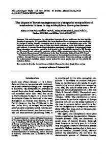
Figure 2. The “Embalse de Guri,” or Caroní River basin was formed by inundation behind the Guri dam at the site of the Raúl Leoni hydroelectric plant. The location of the dam and hydroelectric plant are indicated by the narrow portion of the lake in the extreme northwest. The study island (Isla Redonda) was located in the portion of the lake referred to as “Las Carolinas.” Only a few of the more then 200 islands are represented in this figure. Map by Gerardo Aymard.
Two rivers, the Caroní and the Caura, are the largest in eastern Venezuela. Both are black-water rivers draining the precambrian deposits of the Guianan Shield. The Caroní is by far the better known from the perspective of tourism and accessibility. This region is well known for its mineral deposits and stunning geological formations, the characteristic table-top mountains or tepuis. There are four primate species in this region of Venezuela. We surveyed islands for the presence of howler monkeys (Alouatta seniculus) in 1988 and found individuals on almost every island that supported a patch of forest (Kinzey et al., 1989). We characterized the capuchins (Cebus nigrivittatus) as “widely distributed” in the lake from north to south, but less abundant than howlers. The two sakis species, Pithecia pithecia and Chiropotes satanas, are not sympatric in Venezuela. Before flooding, saki distributions were separated by the Caroní River with white-faced sakis on the right bank and bearded sakis on the left bank. We have limited and anecdotal evidence of primate “migrations” between islands. In the early years of the study when rising and falling water levels were still fresh in the minds of our Venezuelan colleagues, we were repeatedly told stories of howlers drowning during high water periods, still hanging by their tails as water levels receded. Recently, dispersal of howlers between islands or between island and mainland, has occurred and was attributed to low water levels exposing land masses that were previously separated by water (Terborgh,
6
NORCONK AND GRAFTON
personal communication). Nevertheless, it is not a common occurrence for howlers and we have no evidence that sakis have moved among water-bound islands. Research for this study was conducted on a 12.8-hectare island (medium-sized, following Terborgh et al., 1997) called Isla Redonda (Figure 3). The island is a remnant hilltop that has been isolated from the nearby mainland since at least 1981 (CVGEDELCA map, 1981) after the first stage of flooding (1963-1978) (CVG-EDELCA, 1997). The second stage of flooding began in 1978 and was completed in 1986. Parolin collected her first vegetation samples in 1988, approximately 10 years post isolation. Ghost forest (sensu Terborgh et al., 1997) surrounds the present day island, but does not connect the island to other islands or to the mainland even when the lake level is extremely low (personal observation, 2001). Vegetation in the northern portion of the Caroní basin was characterized as low to medium deciduous non-flooded forests (5 to 25 m in height) and shrub savannas by Huber (1986). This description fits well with more detailed work on the island by Aymard et al. (1997). They described the vegetation of Isla Redonda as a dry tropical forest with trees of medium height (maximum height 23 m), consisting of predominantly small stems, growing on rocky quartzite and clayey ferruginous soils. Parolin (1992) characterized distinct regions of high, low, or mixed forest on the island, and Brush (2000) used the terms high or low forest with variable degrees of rockiness, canopy cover, and undergrowth density. Parolin’s 1988-89 samples found the Leguminosae to be
N
A Exposed
B
Protected
Intermediate
1988-89 and 2001-02 plots 1988-89 and 2001-02 strip censuses 2001-02 strip censuses High forest Low forest Trail system 0
50
100
150 Meters
Figure 3. Trail and vegetation map of Isla Redonda. Three plots were measured in 1988-89 and replicated in 2001-02, labeled “protected,” “intermediate,” and “exposed.” The protected and exposed plots measured 25 m2 . The intermediate plot measured 100 m long and 4 m wide. .
CHANGES IN FOREST COMPOSITION
7
the best represented family with three genera of Caesalpinioideae and one genus of Mimosoideae in the top 10 most abundant genera (Parolin, 1992). Annual rainfall averages 1,100 mm (CVG-EDELCA, unpublished). 3.2. Sampling Methods Parolin measured and identified every stem $5.0 cm DBH (diameter at breast height) in 16, 25-m squared plots placed randomly around the island (Parolin, 1992). She and A. Peetz (unpublished) also conducted a strip sample 100 m long and 4 m wide on the south side of the island. In 2001-02, we replicated the measurements she took on two plots on the south side of the island and the strip sample (see Figure 3). In addition, we assigned each stem a leaf phenology score of 0 to 4, where 0 = no leaves, stem presumed dead, to 4 = fully leafed. In addition, we added two new strip samples in 2001 (100 m long and 4 m wide) in the vicinity of the two established plots (see Figure 3). All stems $0.5 cm maximum diameter (trees, lianas, saplings, and understory shrubs) were measured in contiguous 2 m2 blocks along three trails for a total of 250 blocks. Stems smaller than a maximum diameter of 0.5 cm were counted and identified to species when possible. We refer to these data below as evidence for recruitment. We characterized the plots and strip samples as “protected,” “exposed,” or “intermediate” using both windthrow data and distance from the windward (southeastern) edge of the island. The exposed plot was within 50 m of the south edge and approximately 140 m from the southeastern edge of the island. The protected plot was within 100 m of the edge and approximately one-third up the slope to the crest of the island and 250 m from the southeastern end of the island. The intermediate strip sample was approximately 25 m and only about 4 m in elevation from the southern edge and also approximately 250 m from the southeastern end of the island (see Figure 3). Windthrow and temperature were estimated in 2001 using a Kestrel® 2000 Pocket Thermo Wind Meter. Average and maximum wind speed (in knots) were collected at two points on the island, observation point A–on the northwestern corner of the exposed plot—and observation point B–the western end of the strip sample, approximately the mid-point on the southeast side of the island (see Figure 3). The wind meter was hand held 2 m above the ground and pointed toward the direction of maximum wind speed as indicated on the read-out. Maximum wind speed (measured as 3-second gusts) as well as average wind speeds and temperature readings were recorded 60 seconds after the meter was activated. Paired samples from points A and B were taken approximately 15 minutes apart. Data on primate feeding trees were collected in 1991-92 during a 12-month study of the group of nine white-faced sakis (Pithecia pithecia) (see methods in Norconk, 1996). Feeding trees totaling 3,570 stems were identified, labeled, and measured (DBH, height, canopy breadth) and ranked by total feeding minutes. We use feeding tree rank as a reflection of dietary preference of the sakis, with the caveat that feeding tree preferences do fluctuate with annual variation in fruit availability (Norconk, unpublished). 3.3. Analysis We estimated within year (1988-89 and 2001-02) structural variation among vegetation plots using the non-parametric analysis of variance, Kruskal-Wallis test
8
NORCONK AND GRAFTON
(SPSS, v. 7.0). The DBH distributions were truncated at 5 cm as the minimum DBH thus the distributions were not normal. DBH differences in each plot were compared between time samples using Mann-Whitney tests for independent samples. Feeding tree species were ranked by total feeding minutes over a 12-month study in 1991-1992 and we used those ranks to correlate feeding trees with stem abundance in the sample plots using Pearson’s R correlation. We set " values at 0.05 and all tests were two-tailed.
4. RESULTS 4.1. Wind Data Northwesterly winds affect predominantly the southeastern portion of the island. Windthrow speed averaged 2.3 knots (N = 15) with gusts to 6.6 knots at the southeast end of the island (observation point A). Wind speed was lower at observation point B—1.8 knots (N = 15) with gusts to 3.9 knots. Paired samples demonstrated that the windier the conditions, the larger the difference between the two observation points. When maximum wind speed was $4.0 knots, the difference between the two points averaged 2.4 knots compared with a difference of 0.5 knots when maximum wind readings were 20 cm
50
40
30
20
10
0 Exposed
Intermediate
Protected
Plot type
Figure 6. Percentage of dead trees by size category for each of the 2001-02 plots.
The finding that small trees are suffering high losses in the exposed plot was supported by the additional data we collected from the strip samples of 2001. For this sample, we added the category of stems #0.5 cm (greatest diameter). We tallied these very small stems for each 2 m2 block of the sample strips. Small stems averaged 1.31 and 3.46 stems/2 m2 on the exposed and intermediate samples, respectively, and 11.71/2 m2 in the protected area. 4.3. Plant Species Diversity and Impact on Primate Feeding We found a total of 31 species in the three 2001-02 plots. Of these, 51.6% (16 species) were found only in one plot, 25.8% (8 species) were found in two plots, and 22.6% (7 species) were found in all three plots. Since these three plots are within a radius of 150 m, more than half the species found only in one plot could be considered to be rare. Of the more common species (i.e., 16 species that were found in at least two plots), the species representation in the intermediate plot was positively correlated with both exposed (r = 0.868, p < 0.001) and protected plots (r = 0.573, p