Invest Agrar: Sist Recur For (2006) 15(2), 160-170
Changes on landscape heterogeneity and spatial patterning of native forests in Patagonia, Argentina F. Carabelli1*, R. Scoz2, H. Claverie3, M. Jaramillo4 and M. Gómez5 1
National Council of Scientific and Technical Research - Patagonian Andes Forest Research and Extension Center. P. O. Box 14 (9200). Esquel. Province Chubut, Argentina 2 Department of Forest Biometrie, Albert-Ludwig University. Tennenbacher Straße 4 (79085) Freiburg im Breisgau. Germany 3 Forests and Parks General Direction, Sarmiento y 25 de mayo (9200). Esquel. Province Chubut. Argentina 4 Fundación Vida Silvestre Argentina. Av. Córdoba 464 (N3370COR) Puerto Iguazú - Province Misiones. Argentina 5 Patagonian Andes Forest Research and Extension Center. P. O. Box 14 (9200). Esquel. Province Chubut. Argentina
Abstract Native forests in Patagonia have been influenced by human activities since the beginning of the past century. Nevertheless, the availability of aerial photographs to conduct analysis of changes at a landscape level due to anthropic factors is generally restricted to the last decades. Therefore this study was aimed to detect changes of the forest landscape heterogeneity during the last thirty years in the northwest region of Chubut, the middle-located Patagonian province, and to study spatial patterning of forest landscapes. For the first goal, we focused on a 2,000 ha landscape unit with prevailing Austrocedrus chilensis forests. In 466 ha covered by these forests, 41% of this area was negatively affected by forest fires, timber logging followed by livestock grazing and substitution with pine plantations. In contrast, growth of young Austrocedrus forests was verified in 9% of the forest area. Spatial patterns were studied on an area of 10,000 ha showing a high heterogeneity of the distinctive landscape configurations. Key words: Austrocedrus chilensis, fragmentation, landscape patterning.
Resumen Cambios en la heterogeneidad del paisaje y organización espacial de bosques nativos en Patagonia, Argentina Los bosques nativos en Patagonia han estado influidos por la acción del hombre desde principios del siglo pasado. Sin embargo, la disponibilidad de fotografías aéreas para efectuar análisis de cambios debidos a factores antrópicos a escala de paisaje está generalmente restringida a las últimas décadas. En consecuencia, este estudio estuvo orientado a detectar y analizar los cambios de la heterogeneidad del paisaje forestal durante los últimos treinta años en la región noroeste de Chubut, la provincia central de Patagonia en Argentina, y a estudiar la organización espacial de paisajes forestales. Para el primer objetivo, nos concentramos en una unidad de paisaje de 2.000 ha con predominancia de bosques de Austrocedrus chilensis. En 466 ha cubiertas con estos bosques, 41% de esta área fue negativamente afectado por incendios forestales, extracciones forestales seguidas de pastoreo y reemplazo de bosques nativos por plantaciones de pinos. En contraste, el crecimiento de bosques jóvenes de Austrocedrus se verificó en el 9% del área forestal. Los patrones espaciales se estudiaron en un área de 10.000 ha y mostraron una alta heterogeneidad de las configuraciones distintivas del paisaje. Palabras clave: Austrocedrus chilensis, fragmentación, patrón de paisaje
* Corresponding author:
[email protected] Received: 30-05-05; Accepted: 15-03-06.
Changes and patterning of forest landscapes in Patagonia
Introduction Forest landscapes have natural levels of spatial and temporal heterogeneity. Human- induced disturbances tend to alter the «natural» heterogeneity and spatial patterning of these landscapes. The result is that most forest landscapes exist in various states of structural modifications (Loyn and McAlpine, 2001). Several studies assessing human-induced changes of spatial and temporal heterogeneity regarding tree species in forest landscapes have been developed worldwide (Lida and Nakashizuka, 1995; Rescia et al., 1997; Silbernagel et al., 1997, Grez et al., 1998; Roth, 1999; Ripple et al., 2000; Jenkins and Parker, 2000; Puric-Mladenovic et al., 2000; Hessburg et al., 2000; Löfman and Kouki, 2001; Fukamachi et al., 2001, Lawes et al., 2004; Tucker et al., 2005), and even at a global scale (Riitters et al., 2000; Wade et al., 2003). However, such studies are still uncommon in the «south of the south», where Patagonia is placed. Particularly in the Patagonian Andes region of Argentina, strengthening of certain human activities during the last decades is concerned with changes on landscape heterogeneity of native forests. This process has an increasing influence on the degradation of environments and biodiversity reduction. Thus, quantitative evaluation of this phenomenon has become essential to support a decision-making process leading to a more efficient utilization and protection of these ecosystems. On such a context, we considered the native tree species Austrocedrus chilensis (D. Don. Pic. Serm. et Bizzarri), generally allocated in places of favorable microclimatic characteristics and accessible locations that made possible a most unplanned development of human settlements and land uses. Austrocedrus is a forest endemic species of the cold temperate forests of the Patagonian Andes region in Argentina and Chile. In Argentina it forms relatively dense pure stands in a precipitation gradient between 1600-1700 mm/year in the west and 500 mm/year in the east, being the coniferous with the largest geographical distribution, from 37° 08¢ up to the 43° 43¢ L.S. (Bran et al., 2002). It is preferably located at altitudes between 300 and 1000 m according to the latitude, in a belt of up to 60-80 km width. Austrocedrus represents the forest limit with the Patagonian steppe to the east and with the humid forests of Nothofagus to the west (Dezzotti and
161
Sancholuz, 1991), where it usually develops dense mixed forests with the evergreen Nothofagus dombeyi. At present the pure Austrocedrus forests and the mixed Austrocedrus-Nothofagus areas occupy an area of 135,400 ha (Bran et al., 2002). This area is the smallest one between those of all native tree species traditionally used by local people. Forest fires historically represented a great problem in Austrocedrus forests. Between 1890 and 1940 a close correspondence of the European colonization and the installation of sawmills with the increase of fires in Austrocedrus forests was verified (Bondel and Almeida, 1996). Previously, these accidents were attributed to aboriginals that used them as a hunting strategy of Lama guanicoe (Muster, 1971; Fonck, 1900). Many of the present Austrocedrus forests have developed on areas that were affected by big fires (Rothkugel, 1916; Veblen and Lorenz, 1987), emphasizing that still at present fire is the most important disturbance affecting these forests in northwest Patagonia (Veblen et al., 1992). In addition, it has been registered a population increase of up to 40% between 1990 and 2000 in several areas mainly covered with Austrocedrus forests (Bondel, 2000). The non-planned use of Austrocedrus forest areas for sheep and cattle grazing represents other threat for the management and conservation of these forests. This matter prevents natural tree regeneration favoring a transition from close forest to park-like distribution and finally towards open grazing areas (Seibert, 1982). A major evidence of the disturbance regimes and the resulting landscape-scale vegetation patterns on Austrocedrus forests due to overgrazing has been supplied by Veblen and Lorenz (1987, 1988), Veblen et al. (1992) and Kitzberger and Veblen (1997). Timber quality makes these forests greatly appreciated as an important economic resource for the region. In province Chubut, this tree is the second most important native timber species following Nothofagus pumilio (Dirección General de Bosques y Parques, 2004). However logging is currently only allowed where trees had been affected by a disease called «mal del ciprés». The dispersal and increase of the disease is so important in some stands that this logging is somehow operating as a cause of fragmentation of these forests. Furthermore, reforestation with exotic species in pure Austrocedrus forests has also contributed to the reduction of the original area (Loguercio, 1999).
162
F. Carabelli et al. / Invest Agrar: Sist Recur For (2006) 15(2), 160-170
In such a context, we addressed two research topics to carry out this study. Our major interest was focused on the detection and analysis of human-caused changes in landscape heterogeneity for a 30-years period from 1970 to 2001 on Austrocedrus forests at a landscape level. At the same time, we tried to link the more relevant human-caused alterations with «positive» and «negative» changes on landscape heterogeneity. Landscape patterning of forest areas based on a categorical map pattern approach leading to an integrated analysis of the forest landscape structure was the second objective of our study.
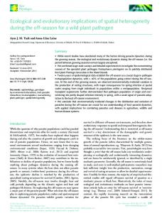
Materials and Methods The study was conducted in the northwest sector of Chubut –42° 38¢ S, 71° 22¢ W- (Figure 1). Climate is temperate with an annual average temperature of 10°C. Precipitations oscillate between 1200 mm/year and 600 mm/year in a West-East gradient of only 30 km.
Polygonization of Austrocedrus forests on the aerial photos and the master satellite image Over an assembled photomosaic from 44 infrared aerial photographs of 1970 we defined patches enclosing Austrocedrus structures. According to Rembold et al. (2000) to ensure consistency of
interpretation we restricted categorisation to a very simple scheme within which the direct readability of the data by the interpreter assured reasonable accuracy. On such a context three classes of tree density —dense, semidense and sparse— were previously identified. Each density class was defined as follows: · Class 1 dense Austrocedrus structures: with an average distance on the field among mature trees less than 5 meters. On aerial photographs they could be seen with a relatively homogeneous dark grey tone and medium (between fine and rough) texture. · Class 2 semidense Austrocedrus structures: with an average distance on the field among mature trees longer than 5 meters and less than 10 meters. On aerial photographs they were seen with a heterogeneous average grey tone and rough texture. · Class 3 sparse Austrocedrus structures: with an average distance on the field among mature trees longer than 10 meters. On aerial photographs they were seen with a heterogeneous clear grey tone and rough texture. Following Baker (2000), we defined a Minimum Mapping Unit (MMU) of 5 ´ 5 pixels, each of 10 meters side resulting in a minimum polygonization area of 2500 square meters. On the previously orthorectified 2001 SPOT PAN-XS master image of 4 bands and 10 ´ 10 meters resolution of the study area, sectors with Austrocedrus structures were polygonized in two phases:
Landscape unit “LagunaBrycham” "
R oads Landscape unit “Lago Baggilt”
N 0
Figure 1.
Los Alerces National Park
Study area 10Km
Study area in province Chubut, Patagonia, Argentina (Detail of the study area on the left side of the picture).
Changes and patterning of forest landscapes in Patagonia
163
1) On a macro-patch level at a landscape scale, four main sectors of the study area with Austrocedrus stands were polygonized. Every patch edge was roughly delineated to achieve a first visualization of quantity, form and distribution of patches in every sector. 2) On a medium and micro-patch level at a stand scale all sectors with Austrocedrus forests with equal or larger size than the MMU on each main sector were polygonized. Through this more precise polygonization, every patch edge was delineated in the most reliable reachable way. Ground controls were performed to: a) identify the herbaceous, shrubby and/or tree vegetation, inside or adjacent to every Austrocedrus patch, b) fix the limits of the patches through perimeter GPS records, c) corroborate or rectify the classifications of density carried out through visual interpretation and d) identify the topographic position and the average height of the Austrocedrus structures.
landscape configurations and spatial heterogeneity. We supported this polygonization by an exhaustive field control where at least 50 GPS points for every landscape element type were checked. Further on, three transects, each of 12 km long, were segmented in 200 equal sections of 64 meters long. On every segment the intersected length of each landscape element type was determined. The absolute and relative frequencies of landscape elements were then calculated. Using the criteria of relative area and connectivity (Forman and Godron, 1986) we set up the type/s of element/s constituting the matrix and then an integrated analysis of the landscape structure was conducted.
Analysis of changes on landscape heterogeneity
On this 2,000 ha landscape unit we identified several qualitative changes of the landscape heterogeneity (Figures 2a-b). These changes are mainly harmful due to forest fires, timber cutting followed by grazing and substitution of Austrocedrus forests with pine plantations (table 1). On the other hand, the growth of young Austrocedrus forests probably not present or indiscernible in 1970 was considered a positive change of the heterogeneity (table 1). During the field surveys Austrocedrus structures that had been previously classified into density class 3 (sparse) on the SPOT master image resulted in complex structures that were not so easy to include in this density class. The following cases were noticed:
On a selected landscape unit of about 2,000 ha named «Laguna Brycham» we practiced an intensive boundary definition of the Austrocedrus patches on the 2001 SPOT XS-PAN master image and the aerial photographs of 1970 to compare the changes of the landscape heterogeneity. During the field work, 170 GPS control points located on the SPOT image and the aerial photos were checked attempting the identification of real changes concerning the presence or absence of Austrocedrus patches, variations on tree density and possible causes of such changes. We considered total (class) area, number of patches, patch density, mean patch size and median patch size into the set of metrics to analyze patch density and size using the software Patch Analyst 3.1 (Rempel and Carr, 2003). In addition we calculated the proportion of forest in landscape for each density class in percentage (Zerda, 1998; Ripple et al., 2000).
Analysis of landscape structure All the different types of elements comprising the landscape were polygonized in a 10,000 ha landscape unit named «Lago Baggilt» to analyse distinctive
Results Changes between 1970 and 2001 of forest landscape heterogeneity at landscape unit «Laguna Brycham»
1. Very separated Austrocedrus trees (distance >30m) immerse in a matrix of N. antarctica or M. boaria, both in density class 2 or 3. 2. Austrocedrus trees not so separated but intimately mixed with the above mentioned tree species, where no predominance of one of them but rather a balanced participation was manifested. 3. Austrocedrus trees quite isolated, with an understory of dense, semidense or opened (without getting to be sparse) regeneration. This situation had been pre-classified not only as density class 3 but also as other non-Austrocedrus forest.
164
F. Carabelli et al. / Invest Agrar: Sist Recur For (2006) 15(2), 160-170
Figure 2a. Distribution of Austrocedrus patches in landscape unit «Laguna Brycham» in 1970. Figure 2b. Distribution of Austrocedrus patches in landscape unit «Laguna Brycham» in 2001.
Assuming that it was impossible to register all different topographic situations and species mixtures regarding these difficulties, we intentionally conducted the analysis of changes on landscape heterogeneity calculating landscape metrics with and without density class 3. The purpose was to show separately both situations and to prevent misunderstandings (i.e. different pixel resolutions and a great heterogeneity of
Table 1.
possible situations involving sparse Austrocedrus patches and other structures recommended extreme care). Considering this situation, we introduced a particularity on the calculation of the proportion of forest in landscape that was computed as a cumulative progression of each tree density class related to the involved class area/s and the matrix area. In this way we could distinguish the proportion of landscape of
Changes of the landscape heterogeneity in the landscape unit «Laguna Brycham»
Causes of changes on heterogeneity
N.º GPS points
Area (ha)
% of total Austrocedrus area (ha)
Forest fires (N) Timber cutting and grazing (N) Substitution of Austrocedrus forests with pine plantations (N) Growth of young Austrocedrus forests not present or indiscernible in 1970 (P)
39 26
107 70
23 15
5
14
3
15
42
9
Total
85
233
50
N: negative change; P: positive change. The indicated 85 GPS points from a total of 170 GPS control points were effectively linked to landscape changes.
Changes and patterning of forest landscapes in Patagonia 30
PFL (%)
25 20 15 10 5
1970
2000
0 C1
C1 + C2
C1 + C2 + C3
165
percentage (41%) concentrated in patches smaller than 1 ha, whereas that percentage was 52% in 2001 (table 4). In the following patch category, between 1 and 5 ha, the percentage of patches in 1970 was 35% and 27% in 2001. In both years a percentage near to 80% (76% in 1970; 79% in 2001) of the patches had areas smaller than 5 ha, thus showing no substantial changes of the landscape heterogeneity concerning patch size and quantity.
Classes
Figure 3. Proportion of forest in the landscape (PFL in %) considered for a cumulative progression of all tree density classes (C1: dense, C2: semidense, C3: sparse).
Landscape structure in the landscape unit «Lago Baggilt»
each forest class for every year (1970 and 2001), hence it was possible to discriminate the contribution of each one (Figure 3). Comparing the landscape metrics between 1970 and 2001 areas of density classes 1 and 3 became smaller (table 2). However, this situation did not correspond with an increase of the number of patches but with a decrease in both cases. A similar behavior was verified for density class 2, whose area increased and also the number of patches. CV patch size was very high in the three classes according to the great variation among maximum (MaxPS) and minimum (MinPS) patch areas in every class (table 3). As it can be observed, 14% of the 488 ha of Austrocedrus forests in 1970 corresponded to the area of the 3 patches of larger size in every class. Meanwhile, the 3 patches of larger size in 2001 represent 24% of the 466 ha of Austrocedrus forests. A patch distribution ranged in five different sizes of area allowed determining that in 1970, the greatest
A total amount of 2100 patches were involved in the discrimination of 16 element types constituting the landscape (figure 4). The calculated relative and absolute frequencies of each identified landscape element type are represented in table 5 (absolute frequency is the number of segments in which a particular landscape element type was identified; relative frequency is the percentage of segments containing the type of landscape element. The sum of relative frequencies exceeds 100% because several element types often coexist in a segment). On transect 1, the first and second more frequent elements totalized 84% (when the total sum of all relative frequencies was 140%), that is, 60% of the total. As in both cases they were prairies —perennial and seasonal—, it can be assumed that they constituted a unit as a specific landscape element type. Considering that the second more common element type, the three density classes of Austrocedrus forests, represented only 24% of the sum of relative frequencies, prairies constituted the matrix in this landscape portion (figure 5).
Table 2.
Landscape metrics at the class level for 1970 and 2001 in the landscape unit «Laguna Brycham»
Density class
Dense
Semidense
Sparse
Landscape metrics
1970
2001
1970
2001
1970
2001
Class area (ha) Number of patches Patch density (100 ha) Mean patch size (ha) Median patch size (ha) CV patch size (%) SD patch size (ha)
61 13 0.7 4.7 1.3 134 6.5
30 11 0.6 2.7 1.4 96 2.8
223 58 3.0 3.8 1.9 165 5.7
303 70 3.7 4.2 0.7 239 9.8
204 61 3.2 3.3 1.3 145 3.9
133 40 1.9 3.5 1.3 239 7.8
166
F. Carabelli et al. / Invest Agrar: Sist Recur For (2006) 15(2), 160-170
Table 3. Maximum and minimum patch sizes (in ha) per density class in 1970 and 2001 Year
1970
Classes
2001
MaxPS
MinPS
MaxPS
MinPS
Class 1 Class 2 Class 3
21,45 28,94 18,84
0,25 0,26 0,25
7,52 58,89 45,86
0,32 0,20 0,27
Total
69,23
0,76
112,27
0,80
On transect 3, the three density classes of Austrocedrus forests comprised the most repeated specific landscape element type (42% of the total sum of all relative frequencies —168%—). The second more frequent landscape element type were prairies, with a relative frequency of 23% of the total. As the difference between relative areas of the first and second more frequent landscape element types was not so considerable, we applied the criterion of connectivity. Following the approach suggested by Forman and Godron (1986) we would raise an imaginary paintbrush 12 times along the 12 km transect if considering the more frequent landscape element type, due to the
Comparison on patch distribution arranged in size intervals
Table 4.
Patch size intervals (ha) Classes
Total 0,25 - 0,50
0,50 - 1,0
1,0 - 5,0
5,0 - 10
> 10
1970 2001
3 3
2 2
5 2
1 4
2 0
13 11
1970 2001
13 25
9 16
24 17
6 6
6 6
58 70
1970 2001
11 8
16 10
18 14
14 4
2 4
61 40
41% (1970) 52% (2001)
35% (1970) 27% (2001)
23% (1970) 20% (2001)
Class 1 Class 2 Class 3
Percentage
N
0
6
Legend Dense ciprés forests Semidense ciprés forests Sparse ciprés forests Maitén-perennial grasslands Ñire forests Lenga forests Perennial grasslands-Wetlands Sensonal grasslands Bare soil Shrublands Water Sauce on riparian places Plantations Burnt ñire forests Burnt ciprés forests Burnt lenga fotests
Figure 4: Landscape element types resulting from the polygonization in sector «Lago Baggilt».
Changes and patterning of forest landscapes in Patagonia Table 5.
167
Frequency of landscape elements in landscape unit «Lago Baggilt» Frequency Transect 1
Frequency Transect 3
Frequency Transect 4
Absolute
Relative
Absolute
Relative
Absolute
Relative
24 10 34 0 10 0 91 76 9 20 0 2 2 0 0 0
12 5 17 0 5 0 46 38 5 10 0 1 1 0 0 0
71 23 46 35 25 13 37 60 2 0 0 2 4 12 0 0
36 12 23 18 13 7 19 30 1 0 0 1 2 6 0 0
15 21 19 0 92 7 8 27 19 0 0 0 0 64 0 0
8 11 10 0 46 4 4 14 10 0 0 0 0 32 0 0
Landscape elements
1. 2. 3. 4. 5. 6. 7. 8. 9. 10. 11. 12. 13. 14. 15. 16.
Dense Austrocedrus forests Semidense Austrocedrus forests Sparse Austrocedrus forests M. boaria - perennial grasslands N. antarctica forests N. pumilio forests Perennial grasslands - Wetlands Seasonal grasslands Bare soil Shrublands Water Willows on riparian places Plantations Burnt N. antarctica forests Burnt Austrocedrus forests Burnt N. pumilio forests
presence of other element types. Meanwhile, for the less connected second element type, prairies, we would raise the brush 17 times. This higher degree of connectivity of Austrocedrus forests, and its major relative area, made this element type the matrix in this landscape portion.
On transect 4, N. antarctica forests (burnt and not burnt) represented 56% of the more frequent landscape elements types (from a total value of all relative frequencies of 139%). Since all density classes of Austrocedrus forests as the second more reiterated specific landscape element type only represented 21%
Figure 5: Distribution of the different landscape element types on Line 1 of Sector «Lago Baggilt». The y axis shows the covering degree on each segment of every landscape element in % and the x axis the number of segments on the transect. Each landscape element type is described in Table 5. This figure represents the proportion, expresed as an area percentage, of each landscape element type on the 12 km long transect segmented in 200 equal sections of 64 meters long.
168
F. Carabelli et al. / Invest Agrar: Sist Recur For (2006) 15(2), 160-170
(from a total value of all relative frequencies of 139%), N. antarctica forests constituted the matrix in this landscape portion.
Discussion The prevailing negative changes of the forest heterogeneity in the landscape unit «Laguna Brycham» were worrisome, considering that 41% of the area currently covered by Austrocedrus forests was affected by different human-caused activities. This degree of alteration is demonstrative of the situation affecting Austrocedrus forests in the whole study area (Carabelli and Claverie, 2005). Thus, it means that at least about 3,100 ha of these forests from a total Austrocedrus area of 7,500 ha (where 2,000 ha belong to density class 1, 3,000 ha to density class 2 and 2,500 ha to density class 3) could be at risk. This is an even more extreme situation considering that our study area has a low level of human impact, whereas sectors with Austrocedrus forests in other places of province Chubut have been strongly affected by forest fires or substituted by coniferous plantations (Carabelli, 2004). Regarding to other studies that analyzed forest fragmentation mainly due to logging (Löfman and Kouki, 2001; Ripple et al., 1991, 2000; Grez et al., 1998), these results are regrettable, because they are not only concealed in different land uses but also some of them are traditionally incorporated in the practices of the local people; hence it is very difficult to promote changes in the customs that were nearer to assessing the enormous fragility and crucial environmental relevance of these ecosystems (Carabelli et al., 2000). Supporting Turner et al. (2001), we must address this issue when considering that given the extensive influence of human land use on landscape structure and function, it is folly to consider the future of any landscape separated from the humans that inhabit or manage it. Spatial distribution of patches referred to the different Austrocedrus density classes was more indicative of the evolution of certain processes that negatively influenced the changes of the landscape heterogeneity. Patches in density class 1 were separated by an average distance of 469 m in 1970 and 527 m in 2001. This situation can be related to the species reaction to frequent forest fires occurred during the first decades of the twenty century (Veblen and Lorenz, 1987, Veblen et al., 1992). The few patches (13) of
dense forest in 1970 corresponded to protected places where aspect, slope and good moisture conditions favored the survival, whereas fewer and more isolated patches (11) in 2001 were mostly influenced by recent forest fires during the analysed period. Low patch density was related to the high dispersion in the patch distribution in the three tree density classes. Characteristics of this dispersion must be analysed considering fire recurrence, different causes of anthropic influence, topographical factors (aspect, slope and altitude), environmental factors (precipitation frequency and distribution, wind and snow effects, temperature influence), soil factors (soil type, effective depth, structure) and competence with other species. On such a context, quantity of Austrocedrus seedlings, seed trees, abundance of exotic and native shrub and herbaceous species, conditions for Austrocedrus regeneration, number of trees affected by the «mal del ciprés» disease, gaps originated by fallen trees, soil characteristics and degree of coverage of adult trees are being recorded with a present complementary research focused on edge sectors of previously selected patches. Analysis of Austrocedrus forest landscape patterns in the study area was based on categorical (or thematic) map patterns, showing data in which the system property of interest is represented as a mosaic of discrete patches. We were concerned with characterization of the composition and spatial configuration of the patch mosaic, which it is the goal of categorical map pattern analysis (McGarigal, 2002). This analysis revealed a high heterogeneity in the distinctive configurations of this landscape sector, concerning the different specific landscape element type constituting the matrix on each transect and the relationships among relative areas of the more frequent landscape element types that also varied noticeably among the different transects. The consideration of the altitudinal gradient, from the sector of valleys towards the hilly area, allowed an approach to an integrated analysis of the structure of this landscape. This way it was observed that the matrix was constituted by prairies in the low and flattest areas, by Austrocedrus forests in the middle sectors of the gradient with irregular (hilly) topography and by N. antarctica forests in the more elevated sectors, where the topography alternated hilly areas with plateaus. A final consideration of our study is that it becomes necessary to support more and detailed research work
Changes and patterning of forest landscapes in Patagonia
about changes on forest landscape heterogeneity not only for Austrocedrus forests but also for other native tree species of the Patagonian region actually and increasingly exposed to the human influence. The population increase and the coupled unplanned development of new land uses besides the strengthening of the traditional ones represent a complex threat for the maintenance of native forests as we know them today. The strong subdivision of rural land associated with new roads, wire fences and buildings is probably one of the most outstanding causes of actual and future forest fragmentation in the Patagonian Andes of Argentina.
Acknowledgments Our research was supported by the German Volkswagen Foundation and the National Council for Scientific and Technical Research of Argentina. We are deeply grateful to Prof. M. Calderón of the Patagonia National University for facilitating the use of the software Erdas Imagine 8.4 and to the Forests and Parks General Direction of Chubut for the use of the software Arcview 3.2a. Two anonymous reviewers suggested many useful comments on the manuscript.
References BAKER W.L., 2000. Measuring and Analyzing Forest Fragmentation in the Rocky Mountains and Western United States, pp. 55-94. In: KNIGHT R.L., SMITH F.W., BUSKIRK S.W., ROMME W.H., BAKER W.L. (Ed.). Forest Fragmentation in the Southern Rocky Mountains. University Press of Colorado. BONDEL C.S., DE ALMEIDA A., 1996. El Bolsón en la cuenca del lago Puelo. Descripción inicial de la relación hombre - medioambiente. Anales de la Sociedad Argentina de Estudios Geográficos. Tomo 20. 69 pp. BONDEL C.S., 2000. Uso del territorio y la explicación geográfica de situaciones territoriales comprometidas. La comarca de El Bolsón en la Patagonia Andina. 50 Congreso Internacional de Americanistas, Warszawa. BRAN D., PÉREZ A., BARRIOS D., PASTORINO M., AYESA J., 2002. Eco-región valdiviana: distribución actual de los bosques de «ciprés de la cordillera» (Austrocedrus chilensis) - escala 1:250.000. Informe Preliminar. INTA-APN-FVSA. 12 pp. CARABELLI F., CLAVERIE H., 2005. Análisis de cambios en los paisajes de bosques de ciprés de la cordillera en el noroeste de la Provincia de Chubut. In: Libro de Actas de
169
la I Reunión sobre ecología, conservación y uso de los bosques de ciprés de la cordillera, Esquel, Chubut, Argentina, 61-66. CARABELLI F.A., 2004. Quantitative analysis of forest fragmentation in Patagonia, Argentina. In: Proceedings of the IUFRO 2004 International Workshop on Landscape Ecology: Conservation and Management of Fragmented Forest Landscapes, Tsukuba, Ibaraki, Japan, 83-87. CARABELLI F., ANTEQUERA S., MARTIN G., GÓMEZ M., 2000. Análisis Ambiental y Social de las Cuencas Hidrográficas Cordilleranas de la Provincia del Chubut. Technical Series N.º 5. CIEFAP-GTZ-DGByP. 60 pp. DEZZOTTI A., SANCHOLUZ L., 1991. Los bosques de Austrocedrus chilensis en Argentina: Ubicación, estructura y crecimiento. Bosque 12, 2, pp. 43-52. DIRECCIÓN GENERAL DE BOSQUES Y PARQUES, 2004. Estadísticas de extracciones forestales. Informe Técnico. 15 pp. FONCK F., 1900. Viajes de Fray Francisco Menéndez a Nahuel Huapi. Valparaíso: C. F. Niemeyer. FORMAN R.T.T., GODRON M., 1986. Landscape Ecology. John Wiley & Sons. FUKAMACHI K., OKU H., NAKASHIZUKA T., 2001. The change of a satoyama landscape and its causality in Kamiseya, Kyoto Prefecture, Japan between 1970 and 1995. Landscape Ecology, 16, pp. 703-717. GREZ A.A., BUSTAMANTE R.O., SIMONETTI J.A., FAHRIG L., 1998. Landscape ecology, deforestation and forest fragmentation: The case of the Ruil Forest in Chile. In: HESSBURG P.F., SMITH B.G., SALTER R.B., OTTMAR R.D., ALVARADO E., 2000. Recent changes (1930s-1990s) in spatial patterns of interior northwest forests, USA. Forest Ecology and Management, 136, pp. 53-83. JENKINS M.A., PARKER G.P., 2000. Changes in the Forest Landscape of the Charles C. Deam Wilderness, Southern Indiana, 1939-1990. Natural Areas Journal, 20, pp. 46-55. KITZBERGER T., VEBLEN T.T., 1997. Influences of humans and ENSO on fire history of Austrocedrus chilensis woodlands in northern Patagonia, Argentina. Écoscience, 4, 4, pp. 508-520. LAWES M.J., MACFARLANE D.M., EELEY H.A.C., 2004. Forest landscape pattern in the KwaZulu-Natal midlands, South Africa: 50 years of change or stasis? Austral Ecology, 29, 6, pp. 613-623. LIDA S., NAKASHIZUKA T., 1995. Forest fragmentation and its effect on species diversity in sub-urban coppice forests in Japan. Forest Ecology and Management, 73, pp. 197-210. LOGUERCIO G., BURSCHEL P., REY M., 1999. El Bosque de Ciprés de la Cordillera: su conservación y uso. Guía Práctica. Folleto de Divulgación N.º 14. CIEFAP. 21 pp. LÖFMAN S., KOUKI J., 2001. Fifty years of Landscape Transformation in Managed Forests of Southern Finland. Scand. J. For. Res., 16, pp. 44-53. LOYN R.H., MCALPINE C., 2001. Spatial Patterns and Fragmentation: Indicators for Conserving Biodiversity in Forest Landscapes. In: RAISON R.J., BROWN A.G.,
170
F. Carabelli et al. / Invest Agrar: Sist Recur For (2006) 15(2), 160-170
FLINN D.N. (Ed.). Criteria and Indicators for Sustainable Forest Management. CAB International. Chapter 19, 391-422. MCGARIGAL K., 2002. Landscape pattern metrics. In: El-Shaarawi A. H. & W. W. Piegorsch (Ed.). Encyclopedia of Environmentrics. Volume 2, pp. 1135-1142. John Wiley & Sons, Sussex, England. MUSTER G.C., 1971. At home with the Patagoniens: A years wanderings over untrodden ground from the straits of Magellan to the Río Negro. London: John Murray. PURIC-MLADENOVIC D., KENNEY W.A., CSILLAG F., 2000. Land Development Pressure on peri-urban forests: A Case Study in the Regional Municipality of York. The Forestry Chronicle, 76, pp. 247-250. REMBOLD F., CARNICELLI S., NORI M., FERRARI G.A., 2000. Use of aerial photographs, Landsat TM imagery and multidisciplinary field survey for land-cover change analysis in the lakes region (Ethiopia). International Journal of Applied Earth Observation and Geoinformation. Volume 2, Sigue 3/4, pp. 181-189. REMPEL R.S., CARR A.P., 2003. Patch Analyst Extension for ArcView: version 3. [en línea]. Disponible en: http://flash.lakeheadu.ca/~rrempel/patch/index.html. RESCIA A.J., SCHMITZ M.F., MARTÍN de AGAR P., de PABLO C.L., PINEDA F.D., 1997. A fragmented landscape in northern Spain analyzed at different spatial scales: Implications for management. Journal of Vegetation Science, 8, 343-352. RIPPLE W.J., BRADSHAW G.A., SPIES T.A., 1991. Measuring Forest Landscape Patterns in the Cascade Range of Oregon, USA. Biological Conservation, 57, pp. 73-88. RIPPLE W.J., HERSHEY K.T., ANTHONY R.G., 2000. Historical forest patterns of Oregon's central Coast Range. Biological Conservation, 93, pp. 127-133. RIITTERS K., WICKHAM J., O'NEILL R., JONES B., SMITH E., 2000. Global-scale patterns of forest fragmentation. Conservation Ecology, 4, 2: 3. (online) URL: http://www.consecol.org/vol4/iss2/art3 ROTH L.C., 1999. Anthropogenic change in subtropical dry forest during a century of settlement in Jaiqui Picado,
santiago Province, Dominican Republic. Journal of Biogeography, 26, 739-759. ROTHKUGEL M., 1916. Los bosques patagónicos. Oficina de Bosques y Yerbales. Dirección de Agricultura y Defensa Agrícola. Boletín N.º 3. Buenos Aires. SEIBERT P., 1982. Carta de vegetación de la región de El Bolsón y su aplicación a la planificación del uso de la tierra. Documenta Phytosociologica 2, 120 pp. SILBERNAGEL J., CHEN J., GALE M.R., PREGITZER K.S., PROBST J., 1997. An Interpretation of Landscape Structure fron Historic and Present Land Cover data in the Eastern Upper Peninsula of Michigan. United States Department of Agriculture, Forest Service, North Central Forest Experiment Station, General Technical Report, NC, 192, 30 pp. TUCKER C.M., MUNROE D.K., NAGENDRA H., SOUTHWORTH J., 2005. Comparative spatial analyses of forest conservation and change in Honduras and Guatemala. Conservation and Society, 3, 1, pp. 174-200. TURNER M.G., GARDNER R.H., O'NEILL R.V., 2001. Landscape Ecology in Theory and Practice. Pattern and Process. Springer-Verlag, New York, Berlin, Heidelberg. VEBLEN T.T., LORENZ D., 1987. Post-fire stand development of Austrocedrus-Nothofagus forests in northern Patagonia. Vegetatio, 71, pp. 113-126. VEBLEN T.T., LORENZ D., 1988. Recent Vegetation Changes along the Forest/Steppe Ecotone of Northern Patagonia. Annals of the Association of American Geographers, 78, 1, pp. 93-111. VEBLEN T.T., KITZBERGER T., LARA A., 1992. Disturbance and forest dynamics along a transect from Andean rain forest to Patagonian shrubland. Journal of Vegetation Science, 3, pp. 1-14. WADE T.G., RIITTERS K.H., WICKHAM J.D., JONES K. B., 2003. Distribution and causes of global forest fragmentation. Conservation Ecology 7(2): 7. [online] URL: http://www.consecol.org/vol7/iss2/art7/ ZERDA H.R., 1998. Monitoring der Vegetations- und Landnutzungsveränderungen durch Brandrodung und Übernutzung im Trocken-Chaco Argentiniens mit Satellitenfernerkundung und GIS. Dissertation. Cuvillier Verlag, Goettingen, Germany, 175 pp.