Article under Review for the International Journal of Spatial Data Infrastructures Research, submitted 2012-12-13
Comparing Approaches and Strategies for NSDI Implementation Between the Developed and Developing World Mohammed O. Idrees1, Vahideh Saeidi2, Yusuf Ahmad Yusuf3, Abdul Rashid M. Shariff4
123
Faculty of Engineering, Department of Civil Engineering, Universiti Putra Malaysia, 43400 UPM, Serdang, Selangor Darul-Ehsam, Malaysia;
[email protected];
[email protected];
[email protected]
4
Geospatial Research Center Universiti Putra Malaysia, 43400 UPM, Serdang, Selangor Darul-Ehsam, Malaysia;
[email protected];
[email protected]
Abstract
This paper reviews Spatial Data Infrastructure (SDI) approaches and implementation strategies of the developed and developing nations with particular focus on Canada, Switzerland, Nigeria and Malaysia. The objective of the study is to explore strategies being planned like the institutional set-up, policy, infrastructure, system functionality and components of SDI for each country in order to make a justified comparison, and as well to uncover the margin between the two categories. The study shows that the social system of a nation has its implications for the successful and sustained implementation of SDI. SDI success also depends on the political will of the leaders as well as accountability and transparency in policy making. In order to gain support of the wider communities of data providers and users, government must provide a harmonized regulatory environment, develop user-oriented SDI and institutionalize responsible governance. The study also shows that devising a promising quantitative assessment model will bring along the much anticipated breakthrough in
This work is licensed under the Creative Commons Attribution-Non commercial Works 3.0 License. To view a copy of this license, visit http://creativecommons.org/licenses/by-nc-nd/3.0/ or send a th letter to Creative Commons, 543 Howard Street, 5 Floor, San Francisco, California, 94105, USA.
1
Article under Review for the International Journal of Spatial Data Infrastructures Research, submitted 2012-12-13
evaluating the performance of a nation’s SDI so as to provide direction for improvement. Finally, it is recommended that developing nations should provide a bedrock that would sustain SDI development and proper implementation.
Keywords: SDI, geospatial data, implementation, performance indicators, sustainable development
1. INTRODUCTION The world we live in, as we know it, had been in continual changes. Parallel to this, also, is the social, economic and environmental processes worldwide experiencing dynamic and fundamental structural modifications. The entrance of geospatial information into the mainstream of commercial activities and the spontaneous advances in information and communication technology (ICT) (Budhathoki, Bruce, & Nedovic-Budic, 2008) has made the idea of global village an unbelievable reality (Groot, 1997). To better enhance, explore and survive in the global competitiveness, nations realized the economic benefits derivable from better management of their spatially varied resources (data assets). This perspective engendered the need for collaboration and cooperation for the enhancement of structural network of data infrastructure amongst all the levels of national governments and the private sectors to facilitate the exchange and sharing of spatial information for accelerated socioeconomic development and improve public service delivery. According to the United Nations Initiative on Global Geospatial Information Management (UN-GGIM, 2012), countries across the globe are building a strong foundation for their geospatial infrastructure and regulatory framework in response to the growing needs for timely and accurate geospatial information for national development. Though a highly challenging task, the need for collaboration and cooperation among the producers and the consumers for enhanced structural network of data infrastructure will facilitate exploiting the full potential of geospatial information and associated technology. Not only that, it will guarantee accessibility to and effective use of geospatial information by the growing community of users for accelerated and sustainable socioeconomic and environmental development (Craig, 2009). Traditionally, it was the mandate of many national surveying and mapping agencies at different levels to collect and maintain specific geospatial data type (Lo & W., 2006; Groot, 1997). As more demand for digital geospatial data increased for knowledge-based decision making by various government and
2
Article under Review for the International Journal of Spatial Data Infrastructures Research, submitted 2012-12-13
commercial users, it became clear that limited access to data is a hindrance. Aside access to data, high cost and time of data production, duplication of efforts, inconsistency of data format, non-availability digital data (Akinyede & Agbaje, 2003; Armenakis, 2008; Bishop, Escobar, Karuppannan, Williamson, & Yates, 2000; Groot, 1997; Mohammadi, Rajabifard, & Williamson, 2010; Nedovic-Budic, Crompvoets, & Georgiadou, 2011; Oyugi & Kayode, 2012) are other difficulties faced by data users. Tackling these drawbacks drive the initiatives for the establishment of spatial data infrastructure (SDI). While all theses problems still persist today, other factors inspire the need for further strengthening of the development and implementation of SDIs. These include budgetary crunch, wide use of the internet and World Wide Web (www), advancement in the development of spatially-enabled technologies, applications and related services, “democratization” of geospatial information, transboundary of geo-related issues, and the evolution of GeoScience (Armenakis, 2008). For the last two decades, significant initiatives have been made to establish SDI at various levels; local, state,national, regional and global levels (Bishop et al., 2000; Budhathoki et al., 2008; Groot, 1997; Grus et al., 2011; Najar, Rajabifard, Williamson, & Giger, 2006; Nwilo & Osanwuta, 2004). Najar, Rajabifard, Williamson, & Giger, (2006); Nedovic-Budic, Crompvoets, & Georgiadou, (2011) highlight the main objectives of SDI initiatives include, among other things, to save time, effort and money in data access and use, promoting economic development, stimulate better cooperation between government and the people as well as nations to foster sustainable environment. Despite the widespread campaign and efforts, the development and implementation of SDI remain imbalanced across the globe (Najar et al., 2006). SDI implementation, hitherto, progresses at varying developmental continuum. This unevenness brings approaches of SDI development and implementation strategies globally into question. In addition to this, most of the SDIs are still faced with the hurdles of implementation, hence less attention is given to performance evaluation. For these reasons, this paper seeks to find answers to the following questions: (a) Does the social system of a nation strongly influence the approach to the development and implementation of SDI initiatives? (b) How can SDI development gain support from a wider community of government and private data users and providers? (c) Are there established performance indicator to evaluate the success of a nation’s SDI? We therefore presume that the development of SDI is dependent on the national economic state of a country. The rest of the paper is organized as follows. Section 2 discusses the concepts of SDI, explaining the components and implementation principles. Brief description of NSDI’s of Canada, Switzerlands, Nigeria and Malaysia are presented in section 3, while section 4 deals with discussion of findings. Finally, section 5 draws the curtain with the conclusion.
3
Article under Review for the International Journal of Spatial Data Infrastructures Research, submitted 2012-12-13
2. CONCEPTS AND PRINCIPLES OF SDI Presidential Executive Order #12906 (1994) defines spatial data infrastructure (SDI) as “the technology, policies, standards, and human resources necessary to acquire, process, store, distribute, and improve utilization of geospatial data”. Several other definitions are given to SDI by (Rajabifard & Williamson, 2000). However, the basic idea is that SDI describes the framework in which geospatial science, data, information and related services and applications are made available to the community of users on the internet to for the discovery, sharing, use and applications of geospatial data to enhance the socio-economic developments and to support accurate and timely decision making. All SDIs consists of the following basic components: spatial data, access, policy, technology, and standards. Figure1 describes the components and principles of SDI. Further information on SDI components can be found in (Armenakis, 2008; Hall, 2011; Masser, Rajabifard, & Williamson, 2008; Masser, 2002; Najar et al., 2006; Nedovic-Budic et al., 2011; Oyugi & Kayode, 2012). 2.1
Components of SDI
The framework data: This consists of the fundamental or core data and nonfundamental datasets (Armenakis, 2008). The fundamental data are georeferenced base data layers such as geodetic controls, road networks, hydrographic data, topographic data, cadastral information, administrative boundaries, etc. upon which other non-fundamental thematic data layers like vegetation cover, geological map, population map etc. are aligned. According to Mohammadi et al., (2010) integrating multi-source non-homogeneous data set is one of the main challenges faced by geospatial data users. Data accuracy, updating, and consistency are other issues of major concern looking at the values and vital role of spatial data in SDI. Access network for data and services is a key feature of spatial data infrastructures. Access network provides the ability to locate geospatial information. It is the “marketplace” where users and data providers meet. Access to data requires service and application development to explore the content of SDI with added capability to process and analyze the geospatial data without the need for the user to understand the complexity behind the technology. To be effective, the need for user to access and discover the information they require and to distribute such information efficiently must be organized in a manner that will facilitate the easy internet search. Technology include the tools and facilities that enable the operations of SDI. The internet and the development of open standard platforms for data exchange
4
Article under Review for the International Journal of Spatial Data Infrastructures Research, submitted 2012-12-13
and sharing, computer and information/communication technology, data storage (geometric and attribute) encoding, data capturing, processing and the geographic information system (GIS) software development facilitates the technological environment upon which the entire SDI revolves. Policy: Sound implementation of SDI relies on enabling laws, regulations and policies cutting across the operational spheres of geospatial life cycle and associated elements. The process of data access, sharing, custodianship, partnership, pricing, implementation principles and approaches, and responsibility must be backed by policy statement and enabling laws. Standards are based on information technology, and constitute the link and "glue" to all national spatial data infrastructure components (CGDI 2005). Open Standards provide a common procedure for interoperability and sharing of data across the SDI. Organizations such as the Technical Committee 211 and the Geographic Information/Geomatics of the International Organization of Standards (ISO/TC211), Open Geo-spatial Consortium (OGC) and World Wide Web Consortium (W3C) have developed various standards for data, technology, processing, etc. Likewise each nation develop their own standards but in most cases in compliance with the international standards. Figure 1: SDI building elements and implementation principles
Source: Amenakis, 2008 2.2
SDI and Performance Assessment
The design, implementation and maintenance of SDI is multi-dimensional and complex in nature, content and development across the globe. This factor makes it more difficult to have a uniform assessment approach that can be used to adequately evaluate the level of performance of SDI implementation. However, extensive body of literatures has proposed approaches for this purpose. The
5
Article under Review for the International Journal of Spatial Data Infrastructures Research, submitted 2012-12-13
works of Grus et al., (2011); INSPIRE, (2011); Kok & van Loenen, (2005); Najar et al., (2006); (Yawson, Armah, & Pappoe, 2009) and (Oyugi & Kayode, 2012) are some of the prominent efforts put forward by researchers in SDI domain to compare, define and device scientific means of evaluating SDI performance of different nations. Despite the research efforts, up till this present moment, SDI performance evaluation approaches are still evolving as a matter of academic exercise and experimentation rather than practical application. On this note, one may be tempted to agree with the argument put forward by Chan (2001), as reported by Kok & Van Loenen (2005) that it will, invariably, be impossible to specify the ideal SDI due to the dynamic changes in SDI development functions and composition. Table 1: Classification of evaluation models
Source: Grus et al., 2011
From the typology of SDI evaluation models in Table 1 above, it is obvious that each of the models has addressed a particular aspect and not the entire components. Kok & Van Loenen, (2005) proposed a model based on organizational indicators. The model, named “organizational maturity matrix”, considers leadership, a vision, communication channels and the ability of self organization as critical indicators. In the authors’ opinion, organizational variable is part of SDI, nonetheless, a part cannot make a whole. The absolute neglect of technical and institutional variables renders the model impotent as an effective tool to assess SDI performance. Similarly, Grus et al., (2011) favours SDI goal-oriented assessment view model. For this model, performance is assessed based on pre-determined goals. According to the proposed model, goals are divided into four: assessment purpose, assessment approach, application and evaluation, each having some
6
Article under Review for the International Journal of Spatial Data Infrastructures Research, submitted 2012-12-13
nodal indicators. A point of observation with adopting this model is that, SDI development is not static. The content and functions continually vary, as observed by Chan (2001), it thus means that, having predefined goals without consideration for functional changes may not yield a reliable assessment outcome. Again, both Goal-oriented and organizational maturity matrix is limited to qualitative assessment, not exhaustive, and can be subjective. As evidence of the foregoing, the economic, technical, social and environmental dimensionality of SDI requires devising quantitative assessment criteria that will be holistic and verifiable. On this basis, INSPIRE (2011) and Najar et al., (2006) proposed approach for monitoring and reporting SDI performance using metadata elements: spatial data set, spatial data services, and network services. The advantages of the method is that, performance indicators consider broad integrating channels of SDI, quantitative, and allows computation of conformance test. Appendix 1 is part of the template designed by the monitoring and reporting team of INSPIRE (downloaded from http://inspire.jrc.ec.europa.eu/ index.cfm/pageid/5022). Though exhaustive in coverage than the other models, some challenges hindering the full implementation are yet to be tackled. Issues about the list of data sets (who will and when to establish the list, agreement on relevant data sets, defining the extent of the data set, whether or not to include derived data set in the list), services (how to establish the list of spatial data services and network services), and other trans-boundary issues need to be resolved. 3 3.1
CASE STUDY The Canadian Geospatatial Data Infrastructure (CGDI)
CGDI is an open information technology infrastructure that is based upon publicly available standards and specification (Habbane, 2009). CGDI objective is to provide Canadians with on-demand access to geospatial information through an interoperable, standard based network built on a host of data, services and technology suppliers. CGDI goal which is to improve Canadians’ quality of life by enhancing decision making location-based information and technologies accessible and sustainable started in 1992 and developed on a continuous product and community models to what it is today. Development of CGDI has taken the form of a host of different initiatives, projects, partnerships, and co-operative activities (Guide to CGDI) - all working collectively towards a national infrastructure for access to geospatial information in Canada. Like other national spatial data infrastructures, the Canadian Geospatial Data Infrastructure formalizes the structure and process for organizing, using and sharing geospatial data and services common to a broad spectrum of
7
Article under Review for the International Journal of Spatial Data Infrastructures Research, submitted 2012-12-13
applications and users within a country. Access to data and services, data policy, the framework data, technology and standards are five major components common to any spatial data infrastructure. To achieve critical mass accessible data, services and compatible applications, Canada strategically implements cooperative partnership without a centralized administration (Kottman, 2002) through GeoConnection. GeoConnection is a national partnership program led by Natural Resources Canada (NRC) that collaborates and partners with all levels of government, private sectors, NGO’s and international organizations in order to build and evolve the CGDI. GeoConnection is the lead agency saddled with the responsibility of coordinating with other auxiliary bodies for efficient implementation. CGDI is composed of framework data, access network to data and services, policies, technology, and standards The Management Board consists of senior government officials from the federal agencies represented on the Inter Agency Committee for Geomatics, and provincial and territorial representatives from the Canadian Council on Geomatics, as well as representatives from academia and industry. It is chaired by the Assistant Deputy Minister of the Earth Resources Sector of Natural Resources Canada. A Policy Advisory Network also supports the work of GeoConnections. Partners in GeoConnection include (Kottman, 2002; Masser, 2002) 3.2
15 Federal Agencies 12 Prov./Terr. Agencies 9 Organizations and Groups 6 Academic Groups 2 Gov't/Industry Associations 21 CCOG Members 12 IACG Members Switzerland Geospatial Data Infrastructure
In 2000 the Swiss Federal Council created an interdepartmental Coordination Group on GIS-matters (GCG). The first task of the GCG was to provide recommendations for strategies concerning GIS, based on users’ needs that it was the basis for a NSDI. The NSDI joins a broad base of stakeholders, the federal administrations with the collaboration and coordination with the private sectors. Launching e-geo.ch program (to coordinate the implementation of NSDI) in 2003, provide a great political support for NSDI and implementation strategy (Hall, 2011).
8
Article under Review for the International Journal of Spatial Data Infrastructures Research, submitted 2012-12-13
In 2003, the Federal Council of Ministers approved the implementation plan for the geoinformation strategy developed by the Federal Coordination Center for Geographical Information and GIS (COGIS). The objective of the implementation plan was to establish a national spatial data infrastructure, easy access to geographic data and to make it available to users at low cost. This led to a radical change in the mapping agency (Swisstopo) from the old business focused on maximization of profits to the optimization of benefits for national economic development at the center stage. The e-geo.ch “contact network” initiative was launched in order to bring together the partners who would be needed to establish sustainable NSDI (http://www.swisstopo.admin.ch). Swisstopo holds the responsibility to make geodata available to the public as stated by the Geoinformation Act (Swisstopo promotes, 2011). The commercial use of official survey and geological data requires a license (Geoinformation Act, SR 510.62) thus, Swiss NSDI is also a business model oriented. On the technical side, a key component in the evolution of the Swiss NSDI was the creation of the INTERLIS data description language which is implemented throughout Switzerland. There is a national geoportal (www.geocat.ch) that allows data access, exploration and discovery (www.geocat.ch). Swiss NSDI consists of coordination and organizational issues, Legal framework and funding, fundamental data, Metadata, Network services Environmental themes and activities, Standards (Hall, 2011). The e-geo.ch is the coordinating body established to implement Swiss NSDI. A steering committee, consisting of 15 representatives from the confederation (COGIS), the cantons (CCGEO), cities and municipalities as well as the Swiss Organization for Geo-Information (SOGI) determines the general direction and the strategies of the program. The national SDI is integrating all public SDIs as well as all other (e.g. private, research) SDI activities. All public and many private institutions, producers and users of spatial data are participating in the SDI (Hall, 2011). 3.3
The National Geospatial Data Infrastructure (NGDI) of Nigeria
In September, 2003, the final draft of the Nigerian Geoinformation Policy was formulated by the Federal Ministry of Science and Technology (Nwilo & Osanwuta, 2004; Oyugi & Kayode, 2012). The vision of the GI Policy is to enhance the optimal use of Geospatial Information as a critical resource in all phases of sustainable national development for the alleviation of poverty and improvement of quality of life of Nigerians by establishing and maintaining an NGDI. The mission of the NGDI, among others, is to generate and disseminate geospatial information, which are vital to the socioeconomic development at the National, State and Local levels, by facilitating cooperation and collaboration among Geospatial Information stakeholders (Onabajo, Akerele, & Babatope,
9
Article under Review for the International Journal of Spatial Data Infrastructures Research, submitted 2012-12-13
2005; Oyugi & Kayode, 2012). To achieve these objectives, the National GI Policy has provided for the establishment of the NGDI Council, Committee and Subcommittee. Like every other nations of the world, increasing awareness of the use of GI for decision-making, coupled with the availability of primary datasets from the Nigerian Satellite missions, the country has realized the need to adopt policies to promote greater awareness and public access to standard and coordinated geospatial data production, management and dissemination by all sectoral institutions/agencies through the establishment of a Geospatial Data Clearinghouse at various levels in the country (local, state and federal) and linkages with the private sectors. The components of NGDI are the fundamental datasets, access network, policy, standards and technology. See (Akinyede & Agbaje, 2003; Onah, 2009) for more information. The NGDI Project in Nigeria has an administrative/organizational framework that is multidisciplinary, inter-agency and inter-sectoral network of institutions coordinated by the lead Agency, the National Space Research and Development Agency (NASRDA) with the mandate to work in close collaboration with the relevant National, State and Local Government Legislative Committees and Geospatial data producers. GI Policy has provided for the establishment of NGDI Council, the NGDI Committee and the NGDI SubCommittee. This arrangement is aimed at removing the institutional barriers that have in the past inhibited geospatial data sharing among the producers and users. The policy provides the coordinating Agency the powers to enforce rules and standards. Agbaje (2005) detailed the organizational structure for NGDI management as follows:
NGDI Council (V. President as chairman and Federal Ministry of Science & Technology as secretariat NGDI committee comprising 27 members drawn across all stakeholders and interest groups 6 other sub-committees
3.4 The Malaysia Geospatial Data Infrastructure (MyGDI) MyGDI is an initiative of the government to develop the National Geospatial Data Infrastructure (NSDI) for Malaysia to provide accurate geospatial data that promotes a sustainable living environment, economic growth and social progress for all Malaysians. Like every other SDI, MyGDI was established in response to enhancing the awareness about data availability, improve access to geospatial information by facilitating data sharing among participating agencies, encourage wider use of geospatial data at all levels and contributing towards strengthening national development. It provides a basis for spatial data exploration, evaluation and applications for users and data providers within all levels of government,
10
Article under Review for the International Journal of Spatial Data Infrastructures Research, submitted 2012-12-13
commercial and non-profit sectors, academia and the public (Hanifah, 2007; MyGDI, 2011). Strategically, MyGDI initiatives are a business-oriented service model that was brought into force in 1997 with Public Administration Development Circular 1, providing Guideline for The Establishment of The National Infrastructure for Land Information System (NaLIS). Its development plan is continuing in nature and designed in phases to encompass foundational geospatial database (2000); data driven (2005); application driven (2010) and service driven (2015) (MyGDI, 2011). MyGDIExplorer application provides a base for geospatial data exploration, evaluation, and applications for users and data providers. It facilitates online access to data and avoid duplication efforts in spatial data collection. The components of MyGDI include geospatial information, access mechanism, policy/legal framework, resources, standards, research and development. The initiatives started from the national level and designed to filter down to the state and local levels under the management of MaCGDI (Malaysia center for geospatial data infrastructure) and the various committees. MaCGDI was formed in 2002 is a center under the Ministry of Natural Resources and Environment (NRE) to facilitate, coordinate and manage geospatial data infrastructure through the development of policies, standards, research and development and skilled human resources by providing customer-focused, cost effective and timely delivery of geospatial data. See (Awang, Ariff, & Nordin, 2009; Hanifah, 2007; MyGDI, 2011). The MyGDI Management structure consists of the National Council:
MyGDI National Coordinating Committee (MNCC), MyGDI Framework Technical Committee (MFTC), MyGDI Standard Technical Committee (MSTC), MyGDI Clearinghouse Technical Committee (MCTC), MyGDI State Coordinating Committee (MSCC) and MyGDI State Technical Committee (MSTC).
4
DISCUSSION
In the previous section, some fundamental concepts and terms within the field of SDI have been defined. The status of Canada, Switzerland (developed countries), Nigeria and Malaysia (developing countries) was reviewed. Table 2 summarizes each of this respective NSDI with a view to comparing the driving force, implementation and development strategy behind the initiatives.
11
Article under Review for the International Journal of Spatial Data Infrastructures Research, submitted 2012-12-13
Table 2: Comparison of Countries NSDI implementation components
COMPONENTS
Description
Data
VARIABLES
CANADA
SWITZERLAND
NIGERIA
MALAYSIA
Year initiated
1992
2000
2003
2002
Model
Business
Business
Business
Business
Strategy
Cooperative partnership without centralized administration
Decentralized
Centralized
Partnership with centralized admin
GM03 CoreModel available
Defined
Available
Analogue
Defined
No
Up to date
NASRDA
MaCGDI
Core datasets
Available
Data Format
Digital
a
Updating
Up to date
Digital, INTERLIS
Maintenance
GeoConnect
Up to date
DXF,
Swisstopo Access
Metadata
Well defined
Well defined
Not well defined
Well defined
Network
Access Mechanism
Web services
Web service
Internet (proposed)
Web-based
Network Architecture
Decentralized
geocat.ch
Clearinghouse Data Transfer Standards
Centralized Centralized
Server services
/web
GEOSTAT
Mygeoportal Server
KML, georss, cityGML
INTERLIS, language
XML
ISO, OGC
ISO standard 1910019118
Data Standard Interoperability Yes
Not defined SON, Standards
ISO
ISO compliance
No
Yes
Not implementation
Well implemented
Yes Implementation Policy
Well implementation
Well implementation Swisstopo
Coordinating Body
12
Article under Review for the International Journal of Spatial Data Infrastructures Research, submitted 2012-12-13
SDI Directive Data Access Pricing
and
GeoConnect
NASRDA
MaCGDI
Product & community based model
No
User driven
Regulated
Yes
Implemented
Yes
Mostly Government
Mostly Government
Regulated
Funding
Mostly Government Institutional
Coordinating Body
Arrangements
Participating Agencies
Mostly Government
Fed Min. of Sc. & Tech Govt. Agencies & Private sector
e-geo.ch Govt. Agencies Private sector
&
NRC
NRE
Govt. Agencies & Private sector No
Govt. Agencies private
&
Well coordinated
Working Groups Well coordinated
Analysis of the definition of SDI by the respective countries under study is similar, likewise, their respective components. However, some implementation issues are at odds. The driving force behind the initiatives differs between developed and developing countries. While promoting data sharing, avoiding duplication, public safety, and prompt and appropriate response to victims of disaster (Batuk, Şengezer, & Emem, 2008; Habbane, 2009) are the fundamental concern in the developed world, the developing countries like Malaysia and Nigeria are still at the level of promoting awareness in the use of geospatial information to address national issues and governance (MyGDI, 2011; Oyugi & Kayode, 2012). Access network is well developed in Canada (Habbane, 2009) and Switzerland (Hall, 2011; Najar et al., 2006). In Malaysia, basic information about data are displayed on MyGeoportal website, though, non-compliance with standards, inadequate metadata and lack of collaboration (MyGDI, 2011) is hindering access to data. There is absolutely no access to data by data users in Nigeria due to bureaucracy and lack of commitment on the part of the government. Canada is an active body in issues related to data standards globally, so also Switzerland in Europe. Thus, standards for data and metadata are well positioned in comparison with the developing countries where power struggle, cultural and political dichotomy, poor spatial information infrastructure and undefined policy are still impedances (Bishop et al., 2000) to reaching agreement on issues of standards and data sharing.
13
Well coordinated
Article under Review for the International Journal of Spatial Data Infrastructures Research, submitted 2012-12-13
4.1
SDI development and social system
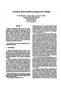
The impact of the social system on the environment popularized the concept of “sustainable development” by the World Commission on Environment and Development (WCED) in its 1987 report entitled “Our Common Future” (WCED, 1987). Barrow, (2006) defined sustainable development as “development that meets the needs of the present without compromising the ability of future generations to meet their own needs”. In the WCED report, social development, economic development and environmental protection were identified as the three fundamental pillars that must be entrenched to ensure sustainability. The jingle, accordingly, creates an awareness among the geoinformation community for urgent need to develop and apply the most practical tools to tackle the challenges of boosting the life support system components. With this, many nations around the world outlined responsive initiatives and develop agendas that could address/redress the dwindling elements of sustainable socioeconomic and environmental indices by establishing a framework of data infrastructure – SDI. Unfortunately, grave disparity in the social system definition has certain impact when a new idea is implemented by different communities. Incidentally, the development and implementation of NSDI for the benefit of the present and future generations entails cordial understanding of an informed society in collaboration with visionary leadership. Visible key factors observed with the developing countries hindering speedy implementation of policies, NSDI inclusive, are political and ethnic polarity (Bishop et al., 2000; Oyugi & Kayode, 2012). Policy makers in multi-ethnic societies, or those with different political ideologies are usually tempted to initial policies with prejudice which at the end will be ineffective for meaningful developmental agenda. For example, the growth of cities in developing countries is more inclined to the market forces rather than sustainable urban planning. The same goes to the rural areas too, where development are absolutely not coordinated. In contrary, urban planning and management are guided by laws and guidelines in the developed world due to the availability of efficient policies on spatial data infrastructure. Power struggles and sense of insecurity hinders cooperation among agencies to share data for the collective benefit of the society (Hanifah, 2007) On education, UNESCO 2012 Report on National Adult Literacy Rate report that Canada and Switzerland have 99% literacy level, Malaysia and Nigeria respectively have 93.1% and 61.3% of their population literate. Though it may be argued that being literate does not make one spatially informed as described in Figure 2 by Masser et al. (2008). Table 2 corroborates similar trend in SDI implementation development, looking at the literacy figure of the respective countries. From the foregoing, it can be inferred that much still need to be done in promoting spatial awareness, even among the educated populace in developing countries, through implementation of policies that will encourage the use of
14
Article under Review for the International Journal of Spatial Data Infrastructures Research, submitted 2012-12-13
spatial information in public and private sectors and other applications that have direct social and economic impact on the people. Bishop et al. (2000) noted that the ability to adopt spatial information technologies in daily routine operations is a distinguishing characteristic of the developed and developing countries. For the developing nations, meanwhile, lack of correlation between population growth and sustainable planning, poor spatial infrastructure, lack of commitment on the part of the leaders, inadequate manpower development account for the differences. Figure 2: Level of spatial-data users and expertise in society
Source: Masser et al.,2008
4.2
Gaining support for NSDI development
Craig (2009), noted that NSDI development is less faced with technical problems than organizational issues. Its development and implementation success is dependent on enabling policies and regulations that will promote wider use of geospatial information in every sphere of a nation’s service delivery. So, for NDSI initiatives to work effectively, radical, cooperative and accountable governance has to be in place. Not that alone, trust must be established between government and the people. Support for NSDI development in countries like Malaysia and Nigeria can be encouraged by strategically implementing technology promotions to decision makers, academia, students, and the general public on the need and potentials of spatial information. A typical example is the 911 spatially-enabled emergency calls in the United States see . Today, wide use of GPS car navigation systems, location-based services (LBS) and location embedded mobile phone for security and intelligence applications, disaster prediction and warning systems, etc. ( see NZGO, (2011) for details on how organizations use SDI) that have a direct impact on the safety of lives and properties, promoting economic development and safeguarding the environment
15
Article under Review for the International Journal of Spatial Data Infrastructures Research, submitted 2012-12-13
broadens the understanding of the inhabitants of developed countries on how important spatial information is. Applications of this type, definitely, will arose the consciousness, understanding and the interest of the populace significantly in developing world to support and cooperate, willingly, with the government on the development of NSDI. To be more enticing Nedovic-Budic et al., (2011) suggests that such technology should be physically accessible, financially affordable and intellectually comprehensible. In the authors’ opinion, other factors that could promote the understanding and cooperation among the various stakeholders include investing in innovation, human capacity and technology development. This will hasten the promotion of the use of spatial information and consequently engender sustained support for NSDI development across the board. Again, understanding the future direction of NSDI, by policy makers at all levels of a nation’s political structure, as a veritable tool for spatially-enabling government (Borzacchiello & Craglia, 2012; I. Masser et al., 2008) will further strengthen their commitment to its success. Social and economic objectives of the government such as improved public service delivery, transparent democratic processes (Groot, 1997), environmental protection and disaster management (Batuk, Şengezer, & Emem, 2008; Mansourian, Rajabifard, Zoej, & Williamson, 2004) and national competitiveness can be tackled effectively. 5. CONCLUSION The objective of this paper was to review the development and implementation strategies of SDI in developed and developing countries using four countries selected from different continents as a case study. The methodology was based on literature sources focusing on revealing factors that are responsible for the imbalance in the approaches of SDI development and implementation across the globe. As mentioned earlier, the dynamic nature of SDI makes the design, development, implementation and maintenance a challenging task. One can see that SDI principles remain the same in concept, however, the technical, organizational and institutional complexity affect the way and manner in which it is developed and sustained across the countries. Our findings show that the social system of a country has implications on the success of SDI initiatives. Successful and sustained implementation will largely depend on the political will of the leaders. Not that alone, accountability and transparency in policy will affect the way participating agencies, the private sectors and the general public will accept and assess its integrity. As reported by Oyugi & Kayode, (2012) citing the success of Kenya and South Africa compared to Nigerian SDI, it is clear that the economic state of a nation cannot be used as a yardstick for measuring the success of SDI, but rather, the vision and focused direction of the government. This fact, therefore, refutes the earlier presumption
16
Article under Review for the International Journal of Spatial Data Infrastructures Research, submitted 2012-12-13
put forward that the success of SDI development is dependent on the economic state of a nation. In response to the second question raised on gaining support for SDI development across a wider community of government/private data users and producers, trust is a key element. To prepare the ground for gaining support, first, the government must provide harmony of regulatory environment where the implementation components run parallel at all tiers of national political structure that will convey the message of commitment to the people, thus fostering cooperation. Second, providing users orientated SDI will attract interest in the use of applications and technology that will facilitate structured and expanding system. Third, to achieve the objectives of the SDI initiative (Najar et al., 2006; NedovicBudic et al., 2011) for the common good of the people, increased governance is necessary. The body of literature reveals that there are, obviously, some research efforts to come out with appropriate model for assessing the performance of SDI implementation. Nonetheless, achieving a comprehensive model that is suitable for all SDI is till far from being reached. This is probably due to the complexity of SDI and the variation in scope, views, functions and content from one country to the other. Most of the models proposed are qualitative. Meanwhile, promising quantitative assessment models such as the one proposed by INSPIRE (2011) is evolving that will provide a breakthrough when fully developed. Though the model is not used to assess the performance of the countries’ SDI in this study, future research will experiment with the INSPIRE model in order to quantitatively evaluate and compare their performance. Conclusively, there is no doubt the developing world still have a lot of challenges in order to meet up with the standard and level of achievements observed, based on the wide use of geospatial applications and technology, in the developed nations’ SDI. We therefore recommend that developing nations leverage on the experience of the “matured” SDI’s to provide a foundation that will facilitate sustained SDI development and implementation. REFERENCES Akinyede, J. O., & Agbaje, G. I. (2003). NIGERIA’S SATELLITE DATA UTILISATION FOR SUSTAINABLE DEVELOPMENT. Armenakis, C. (2008). Spatial data infrastructures and clearinghouses. (C. & Li & Baltsavias, Eds.) (pp. 325–333). London: 2008 ISPRS Congress Book Taylor & Francis Group.
17
Article under Review for the International Journal of Spatial Data Infrastructures Research, submitted 2012-12-13
Awang, A., Ariff, S. M., & Nordin, A. F. (2009). ECONOMIC AND SOCIAL COUNCIL Geo-Spatial Data Accuracy and its Legal Implications in the Malaysian Context *, 7. Barrow, C. J. (2006). Environmental management for Sustainable Development (2nd ed., p. 12). New York: Routledge Taylor & Francis Group. Batuk, F., Şengezer, B., & Emem, O. (2008). RELATIONS BETWEEN DISASTER MANAGEMENT , URBAN PLANNING AND NSDI, 441–444. Bishop, I. D., Escobar, F. J., Karuppannan, S., Williamson, I. P., & Yates, P. M. (2000). Spatial data infrastructures for cities in developing countries Lessons from the Bangkok experience, 17(2), 85–96. Borzacchiello, M. T., & Craglia, M. (2012). Estimating benefits of Spatial Data Infrastructures: A case study on e-Cadastres. Computers, Environment and Urban Systems. doi:10.1016/j.compenvurbsys.2012.05.004 Budhathoki, N. R., Bruce, B. (Chip), & Nedovic-Budic, Z. (2008). Reconceptualizing the role of the user of spatial data infrastructure. GeoJournal, 72(3-4), 149–160. doi:10.1007/s10708-008-9189-x Craig, W. (2009). Governance of NSDI. Retrieved November 23, 2012, from http://www.esri.com/news/arcnews/fall09articles/governance-of-nsdi.html Groot, R. (1997). Spatial data infrastructure ( SDI ) for sustainable land management. Grus, Ł., Castelein, W., Crompvoets, J., Overduin, T., Loenen, B. Van, Groenestijn, A. Van, Rajabifard, A., et al. (2011). An assessment view to evaluate whether Spatial Data Infrastructures meet their goals. Computers, Environment and Urban Systems, 35(3), 217–229. doi:10.1016/j.compenvurbsys.2010.09.004 Habbane, M. (2009). Canadian Geospatial Data Infrastructure Standards for the Public Safety & Security Community. Quebec, November 4, 2009. Hall, M. (2011). Spatial Data Infrastructures in Switzerland : State of play 2011. SPATIAL APPLICATIONS DIVISION K.U.LEUVEN RESEARCH & DEVELOPMENT, (rcr11CH123). Hanifah, F. A. (2007). Implementing National Spatial Data Infrastructure in Malaysia. Malaysia. INSPIRE. (2011). INSPIRE Monitoring and Reporting Drafting Team Monitoring Indicators – Guidelines Document. Kok, B., & Van Loenen, B. (2005). How to assess the success of National Spatial Data Infrastructures? Computers, Environment and Urban Systems, 29(6), 699–717. doi:10.1016/j.compenvurbsys.2004.02.001
18
Article under Review for the International Journal of Spatial Data Infrastructures Research, submitted 2012-12-13
Kottman, C. (2002). Canadian Spatial Data Infrastructure. Lo, C. P., & W., Y. A. K. (2006). Concepts and Techniques of Geographic Information System. New Delh: Prentice-Hall of India private Limited. Mansourian, A., Rajabifard, A., Zoej, M. J. V., & Williamson, I. (2004). Facilitating Disaster Management Using SDI, 1–16. Masser, I., Rajabifard, a., & Williamson, I. (2008). Spatially enabling governments through SDI implementation. International Journal of Geographical Information Science, 22(1), 5–20. doi:10.1080/13658810601177751 Masser, Ian. (2002). A comparative analysis of NSDI ’ s in Australia , Canada and the United States, (October). Mohammadi, H., Rajabifard, A., & Williamson, I. P. (2010). Development of an interoperable tool to facilitate spatial data integration in the context of SDI. International Journal of Geographical Information Science, 24(4), 487–505. doi:10.1080/13658810902881903 MyGDI. (2011). NATIONAL REPORT: NATIONAL SPATIAL DATA INFRASTRUCTURE - MALAYSIA. Permanent Committee on GIS Infrastructure for Asia & the Pacific. Ulaanbaatar, Mongolia. Najar, C., Rajabifard, A., Williamson, I., & Giger, C. (2006). A Framework for Comparing Spatial Data Infrastructures, (November), 6–10. Nedovic-Budic, Z., Crompvoets, J., & Georgiadou, Y. (2011). Spatial Data Infrastructures in Context: North and South. United States: CRC Press, Taylor & Francis Group. Nwilo, P. C., & Osanwuta, D. A. (2004). National Spatial Data Infrastructure for Nigeria – Issues to Be Considered. FIG Working Week, Athens, Greece, May 22-27, 2004 (pp. 1–10). Athens, Greece: FIG International. NZGO. (2011). SPATIAL DATA INFRASTRUCTURE COOKBOOK. Land Information, New Zealand. Onabajo, O. S., Akerele, O. O., & Babatope, S. (2005). Development and Implementation of Metadata Structure in Nigeria – A Case Study of Federal Survey Department Development and Implementation of Metadata Structure in Nigeria – A Case Study of Federal Survey Department. From Pharaohs to Geoinformatics: FIG Working Week 2005 and GSDI-8 (pp. 1–10). Cairo, Egypt.
19
Article under Review for the International Journal of Spatial Data Infrastructures Research, submitted 2012-12-13
Onah, C. C. (2009). SPATIAL DATA INFRASTRUCTURES MODEL FOR DEVELOPING COUNTRIES A case study of Nigeria. Universitat Jaume. Oyugi, M. O., & Kayode, A. A. (2012). Comparative Analysis of the Status of National Spatial Data Infrastructure in Nigeria and Kenya ∗ . Rajabifard, A., & Williamson, I. P. (2000). SPATIAL DATA INFRASTRUCTURES : CONCEPT , SDI HIERARCHY AND FUTURE DIRECTIONS, 1–10. Swisstopo promotes. (2011). swisstopo promotes ! Annual Report 2011. Wabern. UN-GGIM. (2012). UN Initiatives on Global Geospatial Information management. Retrieved November 20, 2012, from http://ggim.un.org/ Yawson, D. O., Armah, F. a., & Pappoe, A. N. M. (2009). Enabling Sustainability: Hierarchical Need-Based Framework for Promoting Sustainable Data Infrastructure in Developing Countries. Sustainability, 1(4), 946–959. doi:10.3390/su1040946
20
Article under Review for the International Journal of Spatial Data Infrastructures Research, submitted 2012-12-13
APPENDIX 1: INSPIRE (2011) - MONITORING AND REPORTING TEMPLATE
21