sensors Article
Data-Gathering Scheme Using AUVs in Large-Scale Underwater Sensor Networks: A Multihop Approach Jawaad Ullah Khan and Ho-Shin Cho * School of Electronics Engineering, Kyungpook National University, Daegu 702-701, Korea;
[email protected] * Correspondence:
[email protected]; Tel.: +82-53-950-7577; Fax +82-53-950-5505 Academic Editor: Leonhard Reindl Received: 31 May 2016; Accepted: 21 September 2016; Published: 30 September 2016
Abstract: In this paper, we propose a data-gathering scheme for hierarchical underwater sensor networks, where multiple Autonomous Underwater Vehicles (AUVs) are deployed over large-scale coverage areas. The deployed AUVs constitute an intermittently connected multihop network through inter-AUV synchronization (in this paper, synchronization means an interconnection between nodes for communication) for forwarding data to the designated sink. In such a scenario, the performance of the multihop communication depends upon the synchronization among the vehicles. The mobility parameters of the vehicles vary continuously because of the constantly changing underwater currents. The variations in the AUV mobility parameters reduce the inter-AUV synchronization frequency contributing to delays in the multihop communication. The proposed scheme improves the AUV synchronization frequency by permitting neighboring AUVs to share their status information via a pre-selected node called an agent-node at the static layer of the network. We evaluate the proposed scheme in terms of the AUV synchronization frequency, vertical delay (node→AUV), horizontal delay (AUV→AUV), end-to-end delay, and the packet loss ratio. Simulation results show that the proposed scheme significantly reduces the aforementioned delays without the synchronization time-out process employed in conventional works. Keywords: Underwater Sensor Networks; Autonomous Underwater Vehicle; Voronoi region; tour-point; data-gathering
1. Introduction and Motivation With the consistent growth in human population, the demand for the exploration of new venues, where abundant resources required for human existence can be found, has increased proportionally over the last few decades. The vast expanses of the oceans constitute such unexplored venues and are considered as reservoirs of energy and food resources. For this purpose, researchers need to continuously collect oceanographic data for the exploration of the immense varieties of minerals and fuel over vast surveying areas and for monitoring the changes that affect the marine ecosystem for observing the evolution of the food resources. For such data collection, sensors are usually deployed over a large field and the collected data is periodically retrieved by visiting each sensor in the field. This conventional approach of offshore exploration and ecosystem monitoring becomes expensive and time-consuming when the surveying area increases. Therefore, most researchers are striving for the development of new exploration techniques and technologies to reduce the operational cost and time for such offshore exploration and monitoring. One of the most promising solutions is the usage of real-time communication between the sensors and the control center [1]. The real-time communications between the sensors and the control center constitute an underwater sensor network (UWSN) that meets the cost effectiveness and time efficiency requirements of the marine applications. In most of these networks, reliable two-way links between the nodes are formed using acoustic technology to Sensors 2016, 16, 1626; doi:10.3390/s16101626
www.mdpi.com/journal/sensors
Sensors 2016, 16, 1626
2 of 20
overcome severe fading conditions and achieve a long-range communication. Most of the installed nodes are battery powered; hence, they have very limited energy resources. Therefore, the nodes are forced to transmit at short ranges to avoid a high power consumption and unnecessary interference with the ongoing communication over the network that may result in unnecessary retransmissions for the nodes. In a networking scenario where large numbers of nodes are deployed, some of the nodes deployed at a distance from the destination have to employ the services of other nodes for efficiently forwarding the data resulting in multihop transmissions over the network. This may increase the rate of utilization of the energy resources for the nodes located close the destination. This unequal rate of energy consumption results in an energy-hole problem for the network [2]. Therefore, various data forwarding schemes that enable the multihop transmissions over the sensor field for delivering the data to the destination and for overcoming uneven energy consumption by controlling certain transmission parameters and forwarding paths [3–5] have been presented. However, these protocols perform poorly in large-scale networks, where the usage of additional bandwidth and energy resources are required for the end-to-end route maintenance in long-term applications. In [6–10], several schemes have been proposed, wherein a mobile node such as an AUV acts as a relay node to collect data from the normal sensors. In these schemes, the mobile node uses a specific trajectory called the “tour-path” to traverse the network. It stops at a specific location called the “tour-point” to retrieve the gathered data from the static normal nodes in a neighborhood. Even though the proposed schemes are able to mitigate the unequal energy consumption, they become ineffective for large-scale networks, where the mobile node trajectories are relatively large; accordingly, considerable data-gathering latency and expensive operational costs are incurred. Further, owing to the constraints of the on-board energy resources, the operational time of a mobile node is limited, consequently reducing the coverage area. The operational problems faced by a mobile node can be addressed if multiple mobile nodes are employed, where each mobile traverses the network on a distinct trajectory [11–16]. Then, these mobile nodes may coordinate with each other to remain in constant interconnection, enabling multihop communications over the coverage area. However, the constantly changing underwater conditions and AUVs’ mobility make it impossible to achieve continuous interconnection among the neighboring AUVs. Under such an imperfect communication scenario, it is assumed that a certain configuration of mobile nodes leads to better coordination. This results in an “on/off” communication model, where multiple AUVs are assumed to be not in constant interconnection owing to the topological changes caused by the varying medium and the AUVs’ mobility [15]. In such scenarios, the AUVs behave like an intermittently connected network (ICN). In [16], authors presented a multiple AUV scheme using the concept of AUVs’ synchronization at agreed locations called rendezvous points (RPs) to achieve multihop communication. Here, two nodes are said to be synchronized when they are connected to each other for communication. The coverage area is divided into a number of regions called lanes wherein an AUV travels on a tour-path and stops at predefined RPs to synchronize with the neighboring AUVs. At the RP, an AUV waits for a neighboring AUV for a fixed period called the “time-out interval”. However, with the fixed time-out interval, it is highly probable that an AUV may miss the opportunity for synchronization with its neighbor owing to the variations in their mobility profiles. This results in the reduction of synchronization frequency that is the number of times an AUV synchronizes with its neighbors in a specific interval. This waiting increases not only the horizontal delay associated with the AUV→AUV communication but also the vertical delay associated with the node→AUV communication at the next tour-point. Even though the time-out interval is extended to be sufficiently long so that the synchronization with the neighboring AUV is not missed, the increase in the horizontal and vertical delay is unavoidable at the following tour-points. In addition, there may be an additional delay caused by an AUV waiting at the RP in case the neighbor has no data to forward. The aforementioned delays are inherent in a multiple AUV data-gathering scheme. Thus, the method of delivering time-critical data in a large-scale network employing multiple AUVs becomes significant.
Sensors 2016, 16, 1626
3 of 20
In this paper, a data-gathering scheme using multiple AUVs is proposed to reduce the data-gathering latency over the large-scale hierarchical UWSN described in [8]. In the proposed scheme, all the AUVs share their status information via a selected node named the “agent-node”, to create a schedule for inter-AUV communication, minimizing both the vertical and horizontal delays. The AUV’s status information includes its mobility profile, operating mode (explained later), cumulative age of the packets in the buffer, and information regarding the neighboring AUV’s schedule. Unlike previous works where the AUV waits at a tour-point for the inter-AUV communication until a neighboring AUV arrives at its own tour-point, in the proposed scheme, the AUV may move forward to another stopping point named the dynamic rendezvous point (DRP) that is calculated in such a way that its arrival time at the DRP coincides with the arrival of the neighboring AUV at its own tour-point. Thus, removing the wasteful waiting time at the tour-point leads to a reduction in both the horizontal and vertical delays. In addition, to avoid a delay in the AUV synchronization, the proposed scheme does not require a time-out interval and speed control in contrast to the fixed-RP [16] and movement-scheduling [17], respectively. The proposed scheme is evaluated in terms of the data transfer delays on the links of node-to-AUV (vertical), AUV-AUV (horizontal), and node-to-sink (end-to-end), AUV synchronization frequency, AUV tour-time, and the packet loss ratio comparing the following schemes: 1. 2.
Fixed-RP scheme [16]: With a time-out interval, an AUV waits for its neighboring AUV at a tour-point that is a fixed RP. Global Relay AUV (GR-AUV) scheme [17]: An additional AUV not belonging to any specific region is employed only for collecting data from the local AUVs. The additional AUV visits each region and acts as a global relay.
The preliminary version of this work was presented in a conference paper [18]. This article is an extension of the conference version with additional details on the system description along with the network design and operation. The detail includes criteria for agent-node selection, AUV operating mode and DRP design. Similarly, additional results related to the vertical and horizontal delays, end-to-end delay, AUV synchronization frequency, AUV tour-time, and the packet loss ratio are included in the performance evaluation section of the paper. The rest of the paper is organized as follows: In Section 2, a summary on the related work is given. In Section 3, the system description is outlined. In Section 4, the operation of the proposed scheme is presented. The performance evaluation is presented in Section 5. Finally, Section 6 concludes this article. 2. Related Work The networking of sensor nodes using multiple mobile nodes is extensively studied to improve the network lifetime and sensing coverage [19–23]. In these studies, it is assumed that the mobile nodes constitute a constantly connected network and acquisition of topology information is not an issue. Thus, a network can be reconfigured to provide full coverage. However, the implementation of these studies may be practically unrealistic to the adverse underwater environment where medium mobility greatly affects the inter-node communication and to overcome the effects may result in large control overhead. For surveying and environment sampling, the authors [11–14] have explored the swarm and flocking algorithms for achieving coordination among multiple mobile nodes over the network. These algorithms also require a constant interconnection of a mobile node with its neighboring mobile nodes for an effective implementation. However, a constantly varying underwater channel leads to drastic changes in the communication probabilities over the network, rendering the constant interconnection of these mobile nodes unrealistic. Therefore, a direct application of these algorithms for the desired coordination, necessary for multihop communication among neighboring mobile nodes, may be difficult to achieve.
Sensors 2016, 16, 1626
4 of 20
In [24,25], the authors have proposed data-gathering schemes using multiple mobile nodes, where first a set of data gathering locations called polling points are generated using spanning tree covering algorithm, then, a spanning tree is generated on the polling points. After that, the spanning tree is decomposed into several subtrees and a mobile node is assigned a subtree. Finally, the mobile node finds the shortest trajectory of polling points of subtree and starts data-gathering. After completion of data-gathering, the mobile node forwards the data to nearby mobile node so that the data can be offloaded to a mobile node that will visit the sink. In these schemes, it is also assumed that the mobile nodes are continuously connected and have the topological information on the neighboring mobile nodes. However, such assumption may not be valid in underwater environment where communication probabilities changes continuously owing to the topological changes and mobility of medium. Therefore, these schemes may not be operable in severe underwater conditions. In addition, the schemes also rely on precise movement control of mobile nodes for effective inter mobile node communication. Therefore, not anyone of the schemes may be a good candidate for implementation in underwater environment where variations in the underwater currents severely affect the mobile node mobility. In [17] the authors have investigated the usage of multiple mobile nodes for data-gathering over a hierarchical network architecture, where mobile nodes are scheduled to meet each other at the synchronization points during certain time intervals. The proposed movement-scheduling scheme is vastly dependent on the mobility of the mobile nodes; therefore, it may be severely affected by the highly dynamic underwater environment. Similarly, the stringent requirement of movement control over the tour-path requires feedback information from the neighboring nodes that may not be readily available. Thus, the movement-scheduling approach may be difficult to implement. To deliver time-critical data, authors in [26] proposed a scheme where multiple AUVs are deployed for data-gathering over the network. In this scheme, the trajectories for AUVs are planned using the value of information on the sensor nodes. The value of information is assigned to each packet and it decays with the passage of time. Every AUV visits a subset of sensor nodes on the assigned trajectory and then resurfaces to forward data to the base station. The proposed scheme maximizes the quality of data collection and balance the task of data collection among the AUVs. However, the global knowledge on the value of information on individual sensor node may be difficult to obtain in highly random underwater environment. Thus, such scheme may cause loss of critical information in real scenario. For reporting the time-critical data, a data forwarding protocol is presented in [27], where the movement of AUVs deployed at the same trajectory is scheduled in such a way that the resurfacing and diving of AUVs can be controlled. The protocol assumes that the AUVs have the same speed, whether they are moving, surfacing or diving, for the trajectories scheduling of the AUVs. Even though, the proposed trajectory scheduling strategies reduce the data forwarding delay and control the frequency of diving and resurfacing, the constraint of same speed of AUVs make it impractical for real time underwater scenario. In this paper, we have developed a mechanism for sharing the topological information among the deployed AUVs that reduces the delay in the multihop data forwarding among the AUVs. It reduces the delay by eliminating the time-out interval and unnecessary waiting at the tour-point that might result in missed synchronizations as in the case of [16]. In addition, unlike [17,24,25], the proposed scheme does not require any movement control of mobile nodes that is necessary for scheduling the neighboring mobile node to achieve effective multihop data forwarding. 3. System Description 3.1. Basic Assumptions It is assumed that a numbers of acoustic sensor nodes are submerged at a certain depth in a given oceanic region for the purpose of data collection, monitoring, and surveying, as described
Sensors 2016, 16, 1626
5 of 20
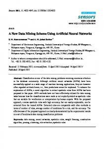
in [28–30]. These sensor nodes are equipped with communication, data processing, and storage modules. The operational capacities of these modules are limited and they can only be operated for aSensors specific 2016,duration 16, 1626 owing to the limited onboard power resources. For a specific event sampling, 5these of 20 sensors nodes are also equipped with the relevant sensing module. The onboard communication module is capable of a discrete discrete power power control. control. Therefore, the sensor nodes can easily adjust their communication node is assigned a unique address for its identification. The relevant communicationrange. range.Each Eachsensor sensor node is assigned a unique address for its identification. The information on the geographical location islocation provided each sensor node at thenode time of relevant information on the geographical is to provided to each sensor at its theinstallation time of its in the network. installation in the network. It is also assumed that several battery-powered AUVs are available in the network and that they work as data mules. These vehicles are equipped with inertial inertial and acoustic acoustic navigational navigational tools tools [31]. [31]. An AUV error correction algorithms to AUV utilizes utilizesthe theonboard onboardnavigational navigationaltools toolsand andspecifically specificallydesigned designed error correction algorithms adjust its location in the Thus,Thus, everyevery AUVAUV transmits a periodic beaconbeacon message [32] to inform to adjust its location in network. the network. transmits a periodic message [32] to the network of its location. By adjusting its buoyancy, an AUVancan control its depth a given inform the network of its location. By adjusting its buoyancy, AUV can control itsin depth in aregion. given The AUV also have sufficient data storage, highly receivingreceiving and processing modules region. The AUV also have sufficient data and storage, andsensitive highly sensitive and processing to handleto the incoming data traffic more efficiently than the sensor nodes in the network. modules handle the incoming data traffic more efficiently than the sensor nodes in the Similarly, network. each AUV each has a AUV transmitting unit that is capable of establishing a reliable long-range forwarding link Similarly, has a transmitting unit that is capable of establishing a reliable long-range more accurately. forwarding link more accurately. 3.2. Network Architecture Architecture 3.2. Network The [8,33] is is considered; considered; it it consists consists of of three three layers, layers, The hierarchical hierarchical underwater underwater network network described described in in [8,33] sensor-layer, AUV-layer, and surface-layer, as shown in Figure 1. The sensor-layer, where N sensor sensor-layer, AUV-layer, and surface-layer, as shown in Figure 1. The sensor-layer, where N sensor 3 nodes nodes are are distributed distributed uniformly, uniformly, is is at at aa depth, depth, D, D, in in aa plane, plane, A, A, of of aagiven givenregion, region, RR3.. These These sensor sensor nodes are anchored firmly to the ocean bottom and are assumed static. The AUV-layer is located nodes are anchored firmly to the ocean bottom and are assumed static. The AUV-layer is located in in another Dand andconsists consistsof of Nv AUVs. AUVs. The The surface-layer surface-layer consists consists of sink that another plane plane at at aa depth, depth, D DAUV AUV