DESIGNING A WEB PLATFORM PARADIGM FOR SATELLITE IMAGES BASED ON USER PREFERENCES Avid Roman-Gonzalez, Natalia Vargas-Cuentas
To cite this version: Avid Roman-Gonzalez, Natalia Vargas-Cuentas. DESIGNING A WEB PLATFORM PARADIGM FOR SATELLITE IMAGES BASED ON USER PREFERENCES. 67th International Astronautical Congress - IAC 2016, Sep 2016, Guadalajara, Mexico. 2016.
HAL Id: hal-01403823 https://hal.archives-ouvertes.fr/hal-01403823 Submitted on 27 Nov 2016
HAL is a multi-disciplinary open access archive for the deposit and dissemination of scientific research documents, whether they are published or not. The documents may come from teaching and research institutions in France or abroad, or from public or private research centers.
L’archive ouverte pluridisciplinaire HAL, est destinée au dépôt et à la diffusion de documents scientifiques de niveau recherche, publiés ou non, émanant des établissements d’enseignement et de recherche français ou étrangers, des laboratoires publics ou privés.
IAC-16, B1, 4,4,x34444 DESIGNING A WEB PLATFORM PARADIGM FOR SATELLITE IMAGES BASED ON USER PREFERENCES Avid Roman-Gonzalez Universidad de Ciencias y Humanidades – UCH, Perú,
[email protected] Natalia I. Vargas-Cuentas Universidad de Ciencias y Humanidades - UCH, Perú,
[email protected] The current satellite imagery management platforms are useful tools, but they assign labels with fix priorities to each patch of a satellite image based on the contents of the image. These tags with fixed priorities do not respond to all needs since each user is different and the uses given to the satellite images depend on the work carried out. Faced with this, we propose a new paradigm in which the priorities of the labels change according to the user who makes the request for the satellite image. For this purpose, we use machine learning and artificial intelligence techniques. With this proposal, one could have a platform that will give a better result at the time of search and manage satellite imagery.
I. INTRODUCTION Satellite images give a very helpful, useful, relevant, and complete information in different fields such as environmental monitoring, disaster management, security and defense, mapping, marine monitoring, agriculture, cartography, and many other applications. Currently, several platforms are providing the service to search, share, analyze, and manage satellite images. Typically, satellite images on these platforms are divided into patches, and each patch has different labels representing their content, these labels could be: 'water', 'forest', 'urban', 'field', among others. Each of these labels has a particular priority according to their predominance in the patch of the satellite image that they represent. With the described above paradigm, users are subject to these labels and must use the priority order of labels established in the database. However, each user is different, and everyone seeks and applies satellite images according to their needs, so the priorities are different from one to other users. That is why in this paper we propose a new paradigm for an adaptive platform on which labels of the satellite images patches may be changing their priorities according to each user and application in which the satellite image will serve. The priority of the labels will be adapted in a personalized way depending on the activity and history search for each user. In that sense, a patch labels will have different priorities depending on the user requirements. To implement this paradigm platform one must apply machine learning and artificial intelligence techniques. One proposes this work motivated by the fact that the Space Agency of Peru (CONIDA) has made the
purchase of a remote sensing satellite that was put in orbit last September 15th. On April 24th, 2014, Peru signed the contract for the acquisition of an Earth observation satellite system. This agreement was signed with the French company Airbus Defence & Space. It should be emphasized that Peru was not only acquiring a satellite, but Peru bought all satellite system that includes: · · · ·
Ground segment (ground station). Space Segment (satellite itself). Access to the constellation of French submetric, metric, and radar satellites. It also includes technology transfer for Peruvian engineers.
This acquisition is a significant step for Peru in its foray into the space age. It has acquired technology with a sub-metric resolution satellite. With this technology, Peru becomes the first Latin American country to have a satellite with a capacity to detect objects smaller than one meter. Among the many applications (both civilian and national security), we can mention: · · · · · · · ·
Biodiversity and the environment monitoring Mining and Geology Agriculture and Water Resources Fishing Monitoring of cultural heritage Land use planning, land and road infrastructure. Management and emergency caused by natural disasters. Protection of our Amazon.
·
National Security (Unlawful Activities: illegal logging, deforestation, smuggling, illicit crops, illegal mining, drug trafficking, terrorism, etc.)
The beneficiaries of these services are public entities of government as well as regional and local governments, contributing to the socio-economic development, poverty reduction, and social inclusion; in addition to promoting scientific and technological research in the country. The PeruSat-1 was launched on September 15th from French Guyana at 8:43 pm (Peruvian time). It is possible to see in Figure 1 an image of the launch. By the above reasons, the acquisition of this satellite system is a significant contribution to the development of the country, and we must be prepared to take advantage of all the information we can provide our images.
Fig. 1 Launch of the first peruvian remote sensing satellite PeruSat-1 viewed from the CNOIS (Centro Nacional de Operaciones de Imagenes Satelitales – National Center of Satellite Images Operation) in Pucasana – Peru via a big screen.
The continuation of this article is organized as follows: Section II shows the state of the art about platform paradigms related to satellite images. In Section III, the description of our proposal is presented. Finally, in Section IV the discussion and our conclusions will be mentioned.
II. STATE OF THE ART This section describes the background of this study. The different management systems of satellite images across different platforms is presented.
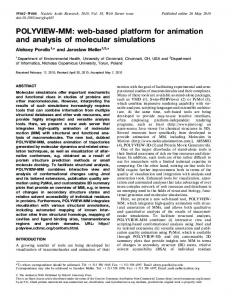
The authors of [1] demonstrate a concept of a knowledge-driven content-based information mining system produced to manage and explore large volumes of remote sensing image data. The concept consists of an offline part and an online interface. The offline part aims the feature extraction, compression, generation of an unsupervised image content-index, and the ingestion of the catalog entry in the database management system. In [2], a novel advanced remote sensing data processing system knowledge-driven information mining (KIM) is proposed. KIM system uses humancentered concepts (HCCs). HCC implements new features and functions (semantic level, collected knowledge, interactive knowledge discovery, and new user interfaces) for improving feature extraction. In [3], the authors present the SARA/Digital Puglia (Synthetic Aperture Radar Atlas). SARA is a remote sensing environment that uses grid technologies and high-performance computing for building a dynamic Earth observation systems for management data coming from space missions. SARA/Digital Puglia was developed in a joint research project with CACR/Caltech, ISI/USC, and the Italian Space Agency. The authors of the work [4] show a content-based image retrieval (CBIR) to effectively and efficiently use information from satellite image repositories. CBIR helps users retrieve relevant images based on their contents. The research presented in [5] shows an end-to-end process for collecting and distributing Earth observation (EO) data to suppliers and consumers worldwide. This process is prepared for the Global Earth Observation System of Systems (GEOSS). The authors explore the possibility of using modular ontologies for formulating smaller interconnected ontologies. In [6] the author present a user requirements analysis for an Earth Observation Based Landslide Information Web Service. The idea is to have a fast and efficient provision landslide information products. The classical approach for designing a management platform for satellite images is to use a feature extraction technique for automatic labeling of the satellite image patches. Each satellite image patch can have many labels, each label with a different priority according to the picture content as the result of the feature extraction and classification process. In Figure 2, one can observe a diagram block for a classical web platform paradigm.
Fig. 2 Clasical aproach for a satellite image management platform
This classical approach assigns labels to satellite image patch, but these labels have static priorities.
III. PROPOSED PLATFORM This work proposes a new paradigm to develop a new adaptative web platform. The idea is to include an artificial intelligence or machine learning block, could be: · Neural network. · Fuzzy logic. · Deep learning. · Among others. An example of the use in remote sensing application could be presented in [7]. Using this artificial intelligence/ machine learning block, try to change the priorities of the satellite image patch according to the preferences of each user. Each user is different, and the application for which he will use the satellite image also is different. The label of a satellite image patch changes depending on the application. Would be necessary to have a database and a control of the access to the system
for each user. Using this historical database, the system must learn which label is most important for the user. In that sense, a patch labels will have different priorities depending on the user requirements. In Figure 3 one can see the block diagram of our proposal including all the strategic block and steps to develop the platform.
IV. DISCUSSION Y CONCLUSIONS Satellite images have many application, both, civil and military applications. PeruSat-1 will provide around 300 images per day, so, a platform to manage this pictures, would be necessary. Each satellite image user is different, and the application for which he needs the image also is different. So, the label priorities depend on the application. Using an adaptative platform that changes de priority of the labels regarding the user, would increase the user satisfaction.
Fig. 3 Diagram block for the proposed paltfarm
[1]
[2]
[3]
V. REFERENCES Datcu, Mihai, et al. "Information mining in remote sensing image archives: system concepts." IEEE Transactions on Geoscience and Remote Sensing 41.12 (2003): 2923-2936. Datcu, Mihai, and Klaus Seidel. "Humancentered concepts for exploration and understanding of earth observation images." IEEE Transactions on Geoscience and Remote Sensing 43.3 (2005): 601-609. Aloisio, Giovanni, and Massimo Cafaro. "A dynamic earth observation system." Parallel
[4]
[5]
[6]
Computing 29.10 (2003): 1357-1362. Gudivada, Venkat N., and Vijay V. Raghavan. "Content based image retrieval systems." Computer 28.9 (1995): 18-22. Durbha, Surya S., Roger L. King, and Nicolas H. Younan. "An information semantics approach for knowledge management and interoperability for the global earth observation system of systems." IEEE Systems Journal 2.3 (2008): 358-365. Albrecht, F., et al. "User requirements for an Earth Observation (EO)-based landslide
[7]
information web service." Landslides and Engineered Slopes. Experience, Theory and Practice: Proceedings of the 12th International Symposium on Landslides (Napoli, Italy, 1219 June 2016). CRC Press, 2016. Camps-Valls, Gustau, Jose Bioucas-Dias, and Melba Crawford. "A Special Issue on Advances in Machine Learning for Remote Sensing and Geosciences [From the Guest Editors]." IEEE Geoscience and Remote Sensing Magazine 4.2 (2016): 5-7.