Enhancing Flood Forecasting and Warning System (EFWS) S.H.M. Fakhruddin Team Leader- Hydrology
[email protected]
1. Background Flood disasters have been increasing over the last 30 years, numbered 173 incidents in 2000-2009, and grew to 182 incidents worldwide in 2010 (EM-DAT database, 2010). By geographical area, Asia and Africa have suffered the most accounting for 60% of all recent disasters. Flooding in these region are caused by either trans-boundary river water flow or river over flow due to prolonged rainfall that result in overflowing rivers and inundated lowland plains. Climate variability and climate change are, in future, expected to increase the frequency and intensity of floods compared to past years. Floods do not respect boundaries, be they national, regional or institutional. Therefore, river basin/ trans-boundary flood forecasting and warning systems or risk management processes are imperative. It involves both all stakeholders working together to enhance and end to end early warning system for flood risk management. It has long been recognized that when communities have advance information on flood forecasts; the adverse effects associated with it are often minimized. Flood warnings provide a well established way to help reduce risks to life and property during flood events. Hydrological forecasts are often used as a component of flood warning systems, and can improve the accuracy of warnings and the lead time available, giving more time to protect property and evacuate areas at risk. Prevalence of traditional forecast practices in various parts of the world reflects the demand for long range forecasts and appropriate interpretation of the probabilistic long lead forecasts to manage uncertainties associated with climate variability. On the other hand, floods are natural phenomena that can also bring benefits to 1
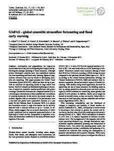
Observation/ monitoring
Data analysis
Prediction
Risk assessment
Potential impact assessment
Warning formulation
Preparation of response options
Dissemination to at-risk communities
Community response
Emergency response plans Public education/ awareness
Mitigation programs
DRAFT
Figure 1: End to End Early Warning System
the communities while seasonal floodplain inundation is essential to maintaining healthy rivers, creating new habitats, depositing silts and fertile organic material, and sustaining wetlands. Thus we cannot simply eliminate floods through structural measures but instead, have to learn ways of coping and managing flood occurrences. Vulnerability to floods depends mainly on human activities, existence of early warning systems, emergency planning, and in putting in to place appropriate legal and institutional frameworks, etc. RIMES has evolved an end-to-end early warning system to enhance the flood forecasting and warning system integrating risk communication tools to enhance flood response at community level. In collaboration with CFAN under Georgia Tech University, USA, RIMES has developed a long lead flood forecasts (1-15 days) system and demonstrated the system successfully since 2004. The demonstrated technology in Bangladesh (Box1) has proven potential opportunity to enhance the flood forecasting capacity in the region. A long lead flood forecast incorporating a decision support system tool empowers individuals and communities to respond appropriately to a threat in order to reduce risk of death, injury, property loss and damage. Using an integrated DSS tool, the forecast information should inform what is happening, what it means to a person, and what decision s/he can then make on action. It should be communicated inclear, simple language and delivered with enough lead-time for the recipient to take anticipatory/ preparatory action. The forecasts system is top down to bottom up scaling, linking hazard detection with warning communication, preparedness, mitigation, and response. It also includes a feedback mechanism that allows postevent assessment to provide guidance to warning system managers and operators. The newly innovated RIMES flood forecasting technology, other water hazard forecasts information and community application could be functional for both reducing the impacts of multiple hazards and to build community resilience among RIMES member states.
BOX-1: Long Lead Flood Forecasts Technology in Bangladesh
The
flood
forecast
technology
for
disaster
preparedness has developed a series of schemes to increase
the
lead
time
of
flood
forecasts
in
Bangladesh. A strong institutional network exists to facilitate the development and application of the flood forecast model. It comprises a National Steering Committee, local working groups, Union Disaster Management Committees and partner NGOs. The flood forecast provides information on onset of flood, and duration and dates of flood recession. It offers enough lead time to interpret and translate forecast information
through
established
communication
channels such as a flag network, SMS bulletins and flood pillars. Evaluation of the benefits of the program has revealed that an estimated average of Tk. 18,637 has been saved per household by receiving early warning in the pilot areas. According to the World Bank (2009), for every US dollar invested, a return of USD 40.85 in benefits over a ten-year period may be realized through the experiment.
2. Rational Early warning is highlighted as a major component of disaster risk reduction in the Hyogo Framework for Action 2005-2015: Building the Resilience of Nations and Communities to Disasters. The framework 2
DRAFT
emphasizes that early warning systems must be centered on the needs of people which means that warnings must be timely and understandable to those at risk. The livelihood of the majority of the people of this region is threatened by water hazards. With the escalating disaster situations flood forecasting has become an urgent survival need of people and economies. As mentioned earlier floods do not maintain any boundary and trans-boundary cooperation on flood forecasting and warning is essential to flood risk Figure 2: Flood effects in last 10 years (EM-DAT database, 2010) management. Early warning by upstream countries can save lives and reduce economic losses. Moreover, cooperation helps to strengthen the knowledge and information base and enlarge the set of available strategies. Widening the geographical area considered in river basin planning enables the identification of effective and more cost-effective solutions. Finally, disaster risk reduction is highly dependent on early warning information and requires data and forecasts from the whole river basin. Though numerous challenges hamper effective data sharing on a real time basis for flood forecasting within the same river basin, RIMES expects to facilitates these issues through bilateral or multilateral process and provide timely and accurate forecasts for the region. At the same time, countries in the region do not have the same level of capacity in flood forecasting and warning system capacity and community preparedness for response. Based on the successfully demonstrated program (i.e. Bangladesh), RIMES is confident in enhancing the flood forecasting and warning system for any river basin by integrating an end to end early warning system (figure 1). This will contribute to disaster mitigation and prevention as well to economic development for the member countries. Over the past decade, there have been significant efforts contributed in this topic by many international communities. RIMES highly acknowledged these initiatives and the supports providing by WMO, through the Associated Program on Flood Management (APFM) and the newly created Helpdesk for Integrated Flood Management1, which provides vital support tools for countries for implementing an integrated approach to flood risk management. In addition, EU tools such as the European Flood Alert System provided by the European Exchange Circle on Flood Forecasting (EXCIFF)2 and European Exchange Circle on Flood Mapping (EXCIMAP) could be replicated in Asian and African countries. Despite this attention, human, economic and social consequences of floods remain high and increasing (Figure 2). This obviously indicates some major gaps in the overall system which need to be identified 1 2
www.floodmanagement.info http://exciff.jrc.ec.europa.eu
3
DRAFT
through extensive early warning audits in each country based on their context. On the other hand, many challenges remain on legislative, financial, institutional, technical and operational aspects at national and local levels may remains and need to be address immediately.
3. Current Status of Flood Forecasting and Warning Services The capacity of early warning and risk management systems are not uniform in all countries. Each country has differential strengths and weakness based on varying conditions. To differentiate flood forecasting and warning system capacities of National Metrological & Hydrological Services (NHMS), RIMES has been categorized the capacity of end to end flood risk management into 6 levels. These categories may able to help NHMS to better understand overall capacities. Level 0: No flood forecasting system, warning dissemination and community level response exits. Level 1: No lead time forecast available. Flood forecasting and warning services are limited or not operational. Significant upgrading and strengthening of the basic data collection and transmission networks is required. Insufficient network coverage and data exchange for hydrological forecasting. Very poor coordination among warning providers and users. Warning dissemination infrastructure is very weak. Level 2: Upgrading and strengthening of the basic data collection and transmission networks is required. Network coverage and data exchange for hydrological forecasting need to be upgraded. Experimental or very limited lead time forecasts exist. Flood forecasting and warning services need to upgraded for operational purposes. Coordination among warning providers and users need to be upgraded. Risk communication system needs to be upgraded. Level 3: 1-2 days lead time available for flood forecast. Basic infrastructures for flood forecasting and warning services are in place. However, upgraded data management procedures (telemetric stations) and improved methodologies and models for flood forecasting are required. Regression or other simple models are generally used to forecast the peak of the water level and approximate time of transit. Some coordination exists but community level understanding and interpretation is poor. Level 4: Observation and telemetric stations are available for all river basins. Long lead forecasts available experimentally. Established flood forecasting and warning services with quality product development in place. Opportunities exist for further improvement through the use of new and innovative technology. Some hydrological tools and methods are used to produce the flood forecasts and warnings (Rainfall routing model, MIKE-11, etc). Coordination among national level users and providers exits. Community level interpretation exists on pilot basis. Level 5 – Well established observation and real time data communication system with backup services. Long lead forecasts available and operational. Well established flood forecasting and warning services with high quality products and opportunities for further improvement through the use of new technology. The systems normally combine products and information from both meteorological and hydrological 4
DRAFT
services. Different tools and methods are used to produce the flood forecasts and warnings (e.g. NWP, QPF, radar, satellite images, hydrological and statistical models and other approaches). Strong coordination among service providers and users established. Risk communication tools exist at the community level. Community interpretation of forecasts and response system applied for flood risk management. A draft initial assessment through expert judgment has been summarized in table-1. Table-1: Current status of flood forecasting and warning capacities3 Country
Observ ations Networ k
Data Transm ission
Hydrological Integration Modeling of NWP Capacity products &