Integration of location-based services for Field support in CRM J. A. Bañares1, P. Álvarez, O. Cantán, P. Fernández, M. Casanovas, P. R. Muro-Medrano Department of Computer Science and System Engineering University of Zaragoza María de Luna 3, 50015 Zaragoza (Spain) Phone: 34 976 762358. Fax: 34 976 761914 1
[email protected] http://iaaa.cps.unizar.es
Abstract This paper shows the infrastructure to provide location-based services for supporting field technicians and service order managers in customer relationship management solutions. Customer relationship management systems may be improved integrating location-based services in enterprise applications, including the Web environment. This integration in different contexts requires component-based and Internet-enabled tools that may be easily customized. 1. Introduction Customer relationship management solutions (CRM) are software applications that allow companies to find, grow and retain customers. For companies using a CRM system, the business strategy is to enhance customer satisfaction and profitability, and therefore the main use of their information systems is oriented to this purpose. Information about location of the customer and the company support services is basic in order to provide a personal service. In fact, location links information about customers with the real world, providing information about its preferences regarding location (where the client lives, what are the nearest resources of the company, etc.) (Sonnen et al. 2000, Gunn 2000, Flower 2000). CRM applications can include tools to support call centers (these range from the simple maintenance of outbound and inbound calls to the use of a knowledge base for troubleshooting problems (Haley 1999)), sales tracking (the tracking of the relationship with a customer over time, including functionality as the classification of customers by various metrics such as site activity or buying activity (http://www.arsdigita.com/doc/crm.html)) and transactions (the scheduling and supporting of personal and resources to conducting business transactions). Traditionally, CRM systems use location information within sales and marketing activities, doing analytical processes of customer information in order to locate and prioritize opportunities that may have been missed if geographic information is not considered. The use of Geographical Information System (GIS) functionality to manipulate spatial data is necessary to derive this added value. Nowadays, wireless communications and location devices (GPS (Kaplan 1996, Krakiwsky 1993)) offer the possibility to associate location with each customer service and to track mobile resources of the company in real time. In a broaden sense, services or application that extends spatial information processing, or GIS capabilities to end users via the Internet and/ or wireless communications are called Location-Based Services (LBS) (ESRI, 2000). The integration of LBS becomes an interesting opportunity to add value to all aspects of business 501
beyond off-line analysis (OpenGIS Consortium 2000, Niedzwiadek, H. 2000). As a result of this, CRM applications may operate over new sources of location information in order to provide better services, and it is in the area of field support where we will find more promising applications. Vantive System, from the PeopleSoft company (http://www.peoplesoft.com), is a CRM client-server solution that automates and integrates sales, marketing, call center, help desk, inventory, procurement, quality assurance, and field service. Vantive Field Service (Vantive 1998 b) is a key software module of the Vantive CRM system that schedules for the technicians who perform services at customer sites, managing field service orders and technician assignments (installation or maintenance teams, or third party providers). Additionally, Vantive Web Field Service (Vantive 1999) gives support for contact field service technicians through mobile communications (with a laptop computer and a standard Web browser, a field technician is always be reachable no matter where travel takes them) and allows technicians track and log actions with minimal data entry. This work presents, from a technological point of view, the integration of different GIS and location based components to provide location-based services opportunities within the Vantive CRM system. As has been presented, in a broaden sense, it is possible to find several cases of application of location-based service in CRM systems. This paper only deals with the opportunities that have been found in the integration of LBS with the Field Service module. Firstly, basic ideas of the Vantive architecture and the technological strategy to incorporate LBS are illustrated. In section 3, the basic components that provide the basic functionality are explained. Finally, in section 4 the conclusions and the future work are presented. 2. Strategy to incorporate LBS in Field Service for different users The Vantive architecture employs a partitioned application client/server model to manage concurrent access to application data form multiple client computers, supporting up to 20.000 user concurrent accesses. Vantive supports tethered and Web clients (Vantive, 1998). A tethered client is physically connected to the corporate network and communicates with the Vantive application Server (iwserver) via Remote Procedure Call (RPC). Each application is stored in the Vantive database, and therefore all tethered clients use the same client program for all Vantive applications. The system also works with the most popular Internet Browser. The user connects to the Vantive system via the Web Server where Java Server Pages (JSP) are stored. JSP pages use JavaBeans that communicate with the Application Server through the VAN Java API. The use of the Field Service application as template allows the developers customization of tethered clients with the Vantive Object Studio tool set. The Object Studio tool set allows developers to customize forms (forms represent the interface of the Vantive applications using standard window and dialog boxes). Vantive utilizes Visual Basic for Applications (VBA) programming to modify attributes and behaviors of the Vantive user interface. The use of VBA is appropriate as an event Handler that allows developers for a fast customization of Vantive forms. However, location-based services require a GIS infrastructure in order to visualize and manage location information. To solve integration issues, a key part of Vantive’s component strategy is to provide developers with a fast, seamless method to integrate Vantive applications into the enterprise infrastructure (PeopleSoft, 2000). The VanAPI is an application program interface that allows developers to access the Vantive services from the major software development environments including Java trough language wrappers. From the
502
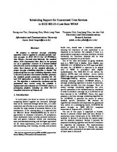
Vantive forms, it is possible to launch our GIS Java components, which provides the framework for all the major location-based services using the field support information trough the Java VanAPI. In the same way, the use of the Web Field Service application as template allows the developers customization of Web clients by modifying JSP to add or remove the available fields associated with a given page. Design considerations such as the use of the OO approach, platform independence, and reuse for Internet in our previous work on GIS software projects, led us to make the decision of using the Java programming language in the construction of the GIS software, and the adoption of a component based layered architecture. In this way, these components may be easily reused to configure a Java GIS framework that access the Vantive database and gives LBS functionality to the predefined forms, or may be easily incorporate in JSP. We have identified two different potential kinds of users in order to provide location-based services around the Field Service module (figure 1 shows typical scenarios): - Service managers who receive service orders via telephone or mail and complete the data of the service agreement and provide resources (field personal) in order to complete it. The service manager is connected as a tethered client. The more interesting added func tionality for services manager are the visualization of the location of all resources (provid ers, field technicians, stores, etc.) and service order addresses. Field service allows the scheduling of service orders according with different criteria such as the skills, or the workload and availability of technicians. However, a visualization of the real-time loca tion of field technicians may improve the scheduling. Through our Java GIS framework it is possible to visualize in a digital map the state and location of each service order and the location of field service technicians and their workloads. GIS visualization functionality allows service manager to visualize planned routes and assign the nearest field service personal. - Field service personal who delivers services. Field technicians use standard web browsers to monitor, update and close assigned service orders using Internet. Service orders may be visualized on a digital map in order to localize client addresses and choose the best route to accomplish the workload. Field technician vehicles or mobile phones may incorporate a GPS device, providing locations in real time to the service manager. It is also possible to notify state changes and consult the Vantive database through Wap.
503
Figure 1. Clients of LBS in the Field Service application. It is easy to provide information to customer about the state of the transaction, or information about providers depending on its location. Customers who ask for a service (via mail, call center or Web) may be provided of a service identifier and might visualize the state of his request. Although, this functionality may be interesting, really customers are not authorized users of the Field service module. Therefore, we do not consider this potential location-based service in this paper. 3. Java Component Based Architecture In general terms, CRM systems are developed using a set of business objects, libraries and tools given by the system provider, and which must be further customized to satisfy the needs of specific clients. The combination of the flexibility offered by the Vantive Java API, the Java Technology Edition and the Java Server Pages enables this customization of the application to meet specific business requirements.
Figure 2. Infrastructure that supports LBS integration in the Field Service application. Template forms and Active Server Pages provided by the Field application may be easily 504
customized, and it is also possible to interact with external applications through the Vantive Java API for building sophisticated custom applications. Therefore, as have been illustrated in the previous section, providing Field Service with location-based service requires component-based and Internet-enabled tools. In the following section, the functionality of components required to provide LBS are briefly explained. Figure 2 illustrates these components. 3.1 Geocoding Geocoding (OpenGIS Consortium., 2000) is the process of transforming a textual term or code, such as an address, place name, o telephone number, into a location. This component supposes some process of cleaning and standardization of the textual representations of address and place names. This component allows obtaining the location of a textual term, or finding layers containing the term. In order to find spatial references of a political unit, such as a village, the component uses the knowledge of political subdivisions such as the subdivision of a country in regions, a region in villages, etc. Data at the level of village may be not available, but data referred to superior levels, which include the village, may be sufficient to answer the question. Our Geocoder component provides the normalization of names, and provides the spatial information of any political unit (address, city, etc.) that has been found in the database. In order to visualize addresses of service orders in a digital map this component provides their coordinates. 3.2 Visualization Our Web Map Server (Fernández 2000) is made in Java and uses the geographical data management rendering capabilities of our GIS kernel to generate and display maps. It adds the functionality needed to fulfill the OpenGIS interfaces. The map server does not receive the requests to show a map directly as an HTTP request, needing thus an intermediate servlet. In this way, we can separate the functionality offered by our Web Map Server and the OpenGIS Interfaces. Therefore, the map server may be accessed through its RMI interface by any other Java program. We have developed three different client applications that may satisfy all potential user Field Server application: - An HTML page is the simplest client. It’s a light page that access to the map server. It has a small download time and it is simple enough to allows home clients of the company, that may visualize the location of the company services, and contact field service technicians, or third party providers to see some useful map with the location of client request. The available layers are fixed in the HTML page. Here, each kind of user (client, field service technicians, or third provider) has restricted the kind of information to visualize by access ing restrictions of Web pages. - A Java applet that accesses the map server. It implements the same map tools that the HTML page, like zoom or pan, and adds other, like the display of coordinates of the mouse over the map, the possibility of changing the scale of the map, or a distance measure. The applet has also a selectable list of layers, styles available in the map server. The advantages of the Java applet are the increase of functionality and the flexibility in the access to the data because all of the parameters are obtained dynamically, as for example the layers to visualize. This client may be more appropriate for call-centre staff to locate and prioritize task. 505
- A visualization tool called JGISview. This visualization application may be installed in a user’s computer to access to the web map server, in the same way as the applet. Local deployment carries improvements in the functionality, overall addressed to specialized users. Now, the user can access to several OpenGIS web map servers, as well as to local files. This third client may be useful for sales and marketing individuals in order to locate and to prioritize opportunities, using thematic mapping, layer control and online analytical processing. The first two clients are more appropriate to Web clients, while the third one is more appropriate to tethered clients such as service managers and to the customization of particular requirements. 3.3 Catalog The OpenGIS Consortium uses the term “Catalog” to describe the set of service interfaces, which supports organization, discovery, and access of geospatial information (Zarazaga, Lopez et al. 2000). Catalog services help users or application software to find information that exists anywhere in a distributed computing environment. A Catalog can be thought of as a specialized database of information about geospatial resources available to a group or community of users. This component allows different branches of an enterprise to share geospatial information, which may be accessed and visualized by authorized staff. Geospatial information is an expensive resource; therefore the catalog is a necessary resource to share this information in a distributed environment. The catalog component helps the Geocoder to find available geodata and provides maps to the MapServer. 3.4 Tracking Services As we have said before, Field Service gives support for contact field service technicians through mobile communications (with a laptop computer and a standard Web browser) and allows technicians track and log actions with minimal data entry. Field service technicians may also access the Vantive server through a simple WAP device and update the state of a service or consult new requests. The tracking of service orders may be improved using location information (Zarazaga, Álvarez et al. 2000). Field technicians tracking assists service manager with the scheduling task. It is possible to track vehicles and field service technicians by means of mobile communications and GPS devices. A mobile device may be a simple GPS device that provides GPS data to the information system via wireless communications (trunking, GSM (see http:// www.benefon.com/)), or more sophisticated vehicle computers with GPS, that may provide accumulated data. Fleet tracking infrastructure (Muro-Medrano et al. 1999) may directly provide mobile locations to the Vantive system and then the Web Map server may build maps that include a dynamic layer showing the location of mobile devices. An HTML client may ask periodically for a new map that includes the new locations, or an applet client may periodically update the layer of mobile devices. 4. Conclusions and future work The integration of LBS with field support components allow field technicians and service managers to improve their works. This paper has presented the first steps to integrate location-based services as a set of Java components in field support applications. One of the most 506
relevant problems we have found is to provide LBS functionality to enterprise applications and Web users. The integration of location-based service in different context requires component-based and Internet-enabled tools. Our decision of using the Java programming language in the construction of the GIS software, and the adoption of a component based layered architecture has made easier the incorporation of LBS functionality. The process to provide LBS has began developing JavaBeans to be included in JSP of Web Field Service in order to visualize maps that shows service order addresses, and building the GIS framework that allows service managers to visualize resources and track field technicians. In the future, we will consider the incorporation of LBS functionality to the rest of Vantive CRM modules. The developed functionality may be easily customized to different client requisites such as the Vantive CRM system. Acknowledgements This work was partially supported by the Comisión Interministerial de Ciencia y Tecnología (CICYT) of Spain through the project TIC2000-1568-C03-01 and the project PROFIT FIT0700002000B270827. The work of Oscar Cantán has been partially supported by the Gobierno de Aragón and the Fondo Social Europeo through a grant. The work of Pedro Fernandez has been partially supported by the Gobierno de Aragón and the Fondo Social Europeo through the grant B109/99. References ESRI, 2000. What Are Location Services? The GIS Perspective. An Esri White Paper. December 2000. Available in http://www.geojava.com . Fernández, P,. Béjar, R., . Latre, M.A , Valiño, J., Bañares, J.A., Muro-Medrano, P.R., 2000. “Web mapping interoperability in practice, a Java approach guided by the OpenGis Web Map Server Interface Specification”. Procd. EC-GIS, may 2000. Flower, D.., 2000. “Mobile e-CRM. The Internet in Our Pocket”. MapWorld Magazine. V. 5, N 2, pp. 5-6. Available in http://www.mapinfo.com/. Gunn, M., 2000. “MapInfo’s Fit in the CRM Market”. MapWorld Magazine. V. 5, N 2, pp. 3-4. Available in http://www.mapinfo.com/. Haley, 1999. CPR via HTTP using XML. A white paper of the Haley Enterprise, Inc. available in http:// www.haley.com. Kaplan, E.D., 1996 Understanding GPS Principles and Applications. Artech House Publishers. Krakiwsky, E.J., 1993. “Tracking the Worldwide Development of IVHS Navigation Systems”. GPS World, V 4, N 10, pp. 40-47. October. Muro-Medrano, P. R, Infante, D., Guillo, J., Zarazaga, J., Bañares, J.A., 1999 “A CORBA Infraestructure to Provide Distributed GPS Data in Real Time to GIS Applications”. Computers, Environment and Urban Systems. V. 23 pp. 271-285. Niedzwiadek, H. 2000. Sun MicroSystems. “All Bussinesses are in pursuit of Java Location Services”. Available in http://www.geojava.com . Open Gis Consortium, Inc., 2000. “A request for technology. In Support of an Open Location Services (OpenLS) Testbed”. Issue Date: 27-October-2000.
507
PeopleSoft, Inc., 2000. “Managing eCustomer Relationships. Extending Customer Relationship Management to the Internet”. PeopleSoft White Paper Series. Available in http://www.peopesoft.com. Sonnen, D., ISSI, and Morris, H., 2000. An IDC White Paper “Location in CRM: Linking Virtual Information to the Real World)”. Available in http://www.mapinfo.com/crm/. Vantive, 1998. Vantive Object Studio, User’s Guide Version 8. Vantive 1998 b. Vantive FieldService with Inventory and Procurement. User’s Guide (Version 8.1). Vantive, 1999. Web Field Service Application. User’s Guide (Version 8.2.1). Zarazaga, F.J., López, R., Nogueras, J., Cantán, O., Álvarez, P., Muro-Medrano P.R. 2000. “Cataloguing and recovering distributed geospatial data, a Java approach to build the OpenGIS Catalog Services” Proceedings of the 6th European Commission GI and GIS Workshop. Lyon, France, 28 – 30 Jun, 2000. Zarazaga, F.J, Álvarez, P., Guillo, J., López, R., Valiño, J., Muro-Medrano, P.R.. 2000. “Use Cases of vehicle location systems based on distributed real-time GPS data”. Telegeo ‘2000. Second International Symposium on Telegeoprocessing. Sophia Antipolis, pp. 53-62. France, 10 –12 May 2000.
508