LADM Implementation Prototype for 3D Cadastre Information System of Multi-Level Apartment in Indonesia Yanto BUDISUSANTO, Trias ADITYA and Rochmad MURYAMTO, Indonesia
Key words: LADM, 3D Casdastre, UML CASE Tools, Information System
SUMMARY Limitations of land supply for infrastructure developments in urban areas led to the development of multi-level and vertical buildings. Massive developments and uses of high rise buildings and constructions such as muti-level apartments and overpass structures in big cities in Indonesia indicated that the demand for space above the ground surface is rapidly increasing in recent years. Regardless the existence of policy and standards of services on land and property registrations, the trend will potentially cause ineffective space management as there is no dedicated information system to efficiently and effectively register and manage information related to boundary of property objects and spaces above the ground and their corresponding rights of ownerships and uses. This paper is dealt with a development of an information system prototype that deals with the registration and management of objects and spaces related to cadastre system (3D cadastre) . Currently the registration system does not store geometry and attributes of ownerships of spaces of property objects in a single system whereas there is a potential opportunity to adopt Land Administration Domain Model (LADM) basic classes in enhancing registration and visualization of land and property spaces. For that reason, a prototype was built based on a simple implementation of LADM basic classes by conforming to the national law on strata title for multi-level appartment and regulation of national land office related to land registration systems. This research uses 3D spatial data stored in CAD format of commercial units in multi-level building in city of Semarang. Enterprise Architect UML CASE Tools 9.3 is used to create a spatial database schema concerning the implementation of LADM basic classes suited to strata title registration system. PostgreSQL with PostGIS spatial extensions were applied to store geometries and attribute data. Delphi programming language with its GLScene components are chosen as the framework to build the prototype that enables 3D spatial data visualization. This research successfully created a desktop-based 3D cadastral information system prototype called SIK3D. SIK3D complies the terms of land administration system which mandates that the system should facilitate data input, processing, and visualization of land parcels and related spaces with their corresponding uses and ownership rights. Through the system, LADM basic classes can be adapted to the appartment’s space ownership registration system that currently is regulated in Indonesia according to the Law. No. 20/2011 on Strata Title for Appartment and Executive Order of Land Office No. 1/2010 on land registration systems.
465 Yanto Budisusanto, Trias Aditya and Rochmad Muryamto LADM Implementation Prototype of 3D Cadastre Information System for Multi-Level Appartment in Indonesia 5th Land Administration Domain Model Workshop 24-25 September 2013, Kuala Lumpur, Malaysia
LADM Implementation Prototype for 3D Cadastre Information System of Multi-Level Apartment in Indonesia Yanto BUDISUSANTO, Trias ADITYA and Rochmad MURYAMTO Indonesia
1. INTRODUCTION Population growth and infrastructure developments in urban areas have extended the utilization of spaces. The space uses are not merely on top of the land parcels anymore, but towards the space above and below the earth's surface. Limitations of land supply for housing and infrastructure developments in urban areas led to the development of multi-level and vertical buildings. Massive developments and uses of high rise buildings and constructions such as muti-level apartments and overpass structures in big cities in Indonesia indicated that the demand for space above the ground surface is rapidly increasing in recent years. Regardless the existence of policy and standards of services on land and property registrations, the trend will potentially cause ineffective space management as there is no dedicated information system to efficiently and effectively register and manage information related to boundary of property objects and spaces above the ground and their corresponding rights of ownerships and uses. The key for successful management of uses and ownerships of property objects and spaces above the ground and their corresponding uses and ownerships rights is the availability of reliable information system. Such information system is expected to be able to handle information related to 2D and 3D geometries and their corresponding attributes that reflect complexities of rights, restrictions and responsibilities of 3D objects. Land Administration Domain Model (LADM) is an international standard that provides basic classes including 2D Spatial Unit and 3D Spatial Unit as well as RRR which are applicable to facilitate 3D property objects registration and visualization for land and space registration (Lemmen et al., 2010). LADM offers a conceptual scheme of the land administration system that covers a parcel (2D) and space (3D). Basic classes of LADM components are used as conceptual references for enhancing good land governance principles in 3D cadastre system prevailing in Indonesia. For this purposes, Law on Multi-level Appartments and Strata Title (Act No. 20/2011) (Anonim, 2011) and standard services on land registration systems (Land Office Executive Order No. 1/2010) are used as technical references (Anonim, 2010). Law on (multi-level) appartment regulates the opportunity to build, manage, and use of appartment buildings. It defines that an appartment building consists of: common objects, common room and appartment room that can be owned by individuals or parties. It regulates the principles on the acquisition and registration of ownership rights of appartment rooms. Meanwhile land office standards on land registration services provides guidelines on technical implementation on a standardised set of services in every land offices in Indonesia in providing survey, right registration, right transfer, etc. In this context, the research was looked only at services related to strata title services, which are: 466 Yanto Budisusanto, Trias Aditya and Rochmad Muryamto LADM Implementation Prototype of 3D Cadastre Information System for Multi-Level Appartment in Indonesia 5th Land Administration Domain Model Workshop 24-25 September 2013, Kuala Lumpur, Malaysia
1. 2. 3. 4.
multi-level apartment property space/property identification; ownerships right registration; ownership right transfer; (temporal) right extension.
Based on the description above, this paper deals with the development of a prototype of 3D cadastre information system that is capable to facilitate the registration of multi-level property spaces using LADM principles and according to national law and services standards. The property objects used in this study were commercial units located in a Plaza in the center of Semarang City called Simpanglima Plasa. The units in this multi-level building are entitled to strata title ownerships. The paper will explore the use of LADM basic units and use of Delphi, PostGIS to manage spatial data and attributes for supporting registration and visualization of multi-level appartment by implementing the principles depicted in the current law and executive order related to strata title registration of property objects. In the context of LADM validation for Indonesia context, previous work has been developed a prototype to assess cadastre implementation according to LADM classes (Sucaya, 2009). However the work has not been looking at 3D space ownership. Meanwhile in the context of 3D cadastre prototype evaluation, the previous work (Aditya et al., 2011) is only focused on visualization aspect and not utilising on the existence of national regulation and international standards. Section 2 will elaborate materials and steps used in order to develop the prototype. Here principles in system modeling according to LADM classes and corresponding steps to utilise Delphi and PostGIS in order to realize the prototype will be discussed. Section 3 will provides steps on the development of the prototype and it will discuss the result. Section 4 will conclude the study.
2. METHODS 2.1 Research materials The data used in this study consist of spatial data of 3D geometries of Simpanglima Plasa Building, Semarang in digital format. The data was produced from field survey and design plan validation resulted from joint study between the Department of Geodetic Engineering at Universitas Gadjah Mada (UGM) and National Land Office in 2011. Subsequently, the attribute data regarding individual space utilization in the building of Simpanglima Plasa were obtained from the management unit of the Building. 2.2 Research tools The tools used in this research include the hardware and software. The software used include AutoCAD Map 3D 2011 for editing and making a 3D object and also Google Earth Extension for AutoCAD to convert 3D spatial data dwg to kml format. Autodesk 3DS Max 2009 was used to change the spatial data format from CAD format into 3DS format. FWTools was used to convert data from KML format (Keyhole Markup Language) into spatial geometries stored in PostgreSQL PostGIS. Enterprise Architect version 9.3 is used as a UML CASE tool to create conceptual and logical models in the form of class diagrams, then generated into a PostgreSQL DBMS applications in DDL format. PostgreSQL with PostGIS spatial extensions 467 Yanto Budisusanto, Trias Aditya and Rochmad Muryamto LADM Implementation Prototype of 3D Cadastre Information System for Multi-Level Appartment in Indonesia 5th Land Administration Domain Model Workshop 24-25 September 2013, Kuala Lumpur, Malaysia
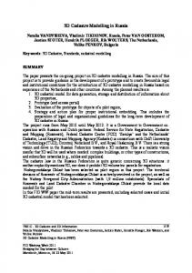
used to manage geometry and attribute tables. Delphi 7 is used to create an application user interface with the support of GLScene as a library for visualizing 3D object. 2.3 Prototype development processes 2.3.1. Data Collection As mentioned earlier, the data were produced from field survey and drawing plan validation activities done by National Land Office and UGM. The data was available in CADformat whereas the attribute data was available in papers. 2.3.2. Data Processing The main data processing activities involve the development of solid model out of CAD survey data previously gained. For ths purpose, firstly the CAD files (export file) were converted as KMLformat using GoogleEarth Extension for AutoCAD. Secondly, CAD data were converted into 3DS using 3DSMax 2009. Data Modeling The model development phase includes the identification on the compliance of LADM basic classes with the Law on Appartment. Further, a conceptual model that describes classes of 3D object ownership registration system and their linkages was drawn. The conversion from comceptual into logical model was done using the Enterprise Architect version 9.3 software as a UML CASE Tools. The schema was then implemented and populated using PostgreSQL with PostGIS extension. DDL is executed on the SQL editor in the DBMS software into a physical data model of spatial database for 3D cadastre information system.The classes that exist in the conceptual model were then realized in the form of geometry and attribute tables. PostGIS stored geometry data of this study as multipolygon Z type. System Design The system was intended to facilitate four standard of services in appartment/flats units (strata title) as mandated in The Executive Order of Chif of Land Office No. 1/2010, as mentioned in Section 1. The system was also intended to be used easily by typical land office operators when dealing with the typical of four types of registration services. User interface design was created using Delphi 7. Figure 1 shows the structure of the interface design of the designated 3D cadastre information system. In general the user interface facilitate registered users to do : 1. deed/certificate checking (exploring the survey and attributes data); 2. ownership right processing (first registration and transfer); 3. ownership right transfer. Guests could use the application but it will be limited to search and view only capabilities.
468 Yanto Budisusanto, Trias Aditya and Rochmad Muryamto LADM Implementation Prototype of 3D Cadastre Information System for Multi-Level Appartment in Indonesia 5th Land Administration Domain Model Workshop 24-25 September 2013, Kuala Lumpur, Malaysia
User Data Application Data User Name : Admin Password : admin
User Data and Authority Application Administrative Area Data
Right and Basic Registration Data Measurement Drawing Data
User Name : Certificate Check Password : cek
3D Cadastre Information System
Registration Map Data Personal Data
Measurement Document Data
Corporation Data
Parcel Data
Government Data User Name : First Services Counter Password : awal
Notary Data Notarial Deed Data
Verification Page (Login)
Separation Deed Data Livable Permissions Data
Level Data
User Name : Services Process Password : proses
User Name : Final Services Counter Password : akhir
User Name : Guest Password : guest
Sketch Drawing Data
Room Data Certificate Data
Other Room Data
Ownership Data
SIK3D Versi 1.0
Figure 1.Structure of interface design of 3D Cadastre Information System
3. RESULTS AND DISCUSSION 3.1 Data models The data used in this study consist of spatial data of 3D geometries of Simpanglima Plasa Building, Semarang in digital format. The data was produced from field survey and design plan validation resulted from joint study between the Department of Geodetic Engineering at Universitas Gadjah Mada (UGM) and National Land Office in 2011. Subsequently, the attribute data regarding individual space utilization in the building of Simpanglima Plasa were obtained from the management unit of the Building. The basic classes of LADM development model to the Law No 20/2011 on Appartment is presented in Figure 2. Figure 3 depicts the classess but it is organised in accordnace with Executive Order of Land Office No. 1/2010 on service standards in land registration. From the logical modeling activity, it produces tables and the linkages between the tables utilised in the system, i.e. 3D cadastral information system (see Table 1).
469 Yanto Budisusanto, Trias Aditya and Rochmad Muryamto LADM Implementation Prototype of 3D Cadastre Information System for Multi-Level Appartment in Indonesia 5th Land Administration Domain Model Workshop 24-25 September 2013, Kuala Lumpur, Malaysia
Strata title
Building certificate
Freehold Title Common equipment
Building Rights Right parcel
Right to rent
Common facility
Right to Use Parcel Rights
Space rights
State Land
person
Parcel Registration
legal entity
Space Registration
2D Spatial Unit
government Land rights
General Appartment
Special Appartment
state land 3D Spatial Unit
customary land
State-owned Appartment
Commercial Appartment
Figure 2. Basic classess of LADM development diagram
From assessing the Law and its conformance to LADM, here is a related description of the figure: a. LA_Party is the ownership classs that can be in forms of person, legal entity or government; b. LA_RRR is developed towards parcel rights and space rights. Further, rights on parcels can be freehold and leasehold. Space rights can be in forms of strata title, building certificate, common facility and common equipment; c. LA_BAUnita is registration system for 2D (parcel) and 3D (space); 470 Yanto Budisusanto, Trias Aditya and Rochmad Muryamto LADM Implementation Prototype of 3D Cadastre Information System for Multi-Level Appartment in Indonesia 5th Land Administration Domain Model Workshop 24-25 September 2013, Kuala Lumpur, Malaysia
d. LA_SpatialUnit refers to objects to which the system register. located on 3D Spatial Unit: Strata Title 1,1
Strata title
located on 1,1
Common facility
3D spatial Unit: Space/Building
3D Spatial Unit : common equipment
located on 1,1
Common equipment
2D spatial Unit: Parcels
Admin. Unit: 2D parcels
3D Spatial Unit: Common facility
located on 1,1
Administratif Unit
Admin. Unit: 3D spaces
related to Spatial Unit
person related to
legal entity
government
association 0...n
Figure3. Conceptual model of spatial database for 3D Cadastre Information System
Figure. 3 is considered as a conceptual spatial databases system conforming to the 3D cadastre information system designated. Enterprise rules for the schema is briefly given as follow: - each parcel consist of one or many spaces; - each space is located on a parcel; - each right holder could have one or more spaces; - each space is owned by a particular right holder; - each right holder is connected to regulation and law concerning rights restriction and responsibilities attached to the objects; - mortgage restrict right holder ownership rights. The following is Table 1 that shows the high-level design of the spatial database that will be used in the system.
471 Yanto Budisusanto, Trias Aditya and Rochmad Muryamto LADM Implementation Prototype of 3D Cadastre Information System for Multi-Level Appartment in Indonesia 5th Land Administration Domain Model Workshop 24-25 September 2013, Kuala Lumpur, Malaysia
Table 1. SIK3D spatial database table design No Class Object Personal Data 1 LA_Party Corporation Data Government Data Parcel Data Right and Basic Registration Data Measurement Drawing Data Measurement Document Data LA_SpatialUnit Data petapendaftaran 2 2D Administrative Area Data : DesadanKelurahan Kecamatan Daerah tingkat II Daerah tingkat I 3D Spatial data geometry LA_SpatialUnit Room Data 3 3D Floor Data Room Sketch Data Separation Deed Data Livable Permision Data 4 LA_RRR Certificate Data Ownership Data Notarial Deed Data 5 Legal_Aspect Notary Data
Table Name tb_perorangan tb_badan_hukum tb_instansi_pemerintah tb_bidang tb_asalhak_dasarpendaftaran tb_gambar_ukur tb_surat_ukur tb_peta_pendaftaran tb_desa_kelurahan tb_kecamatan tb_kab_kodya tb_propinsi tb_geometri_ruang tb_ruang tb_tingkat tb_gambar_denah tb_akta_pemisahan tb_ijin_layak_huni tb_sertifikat tb_kepemilikan tb_akta_notaris tb_notaris
3.2. Prototype of the 3D Cadastre Information System Prototype of the 3D Cadastre Information System is called SIK3D version 1.0. The prototype has functions that mainly to support registration and visualization regarding appartment objects and their corresponding ownership rights. LADM basic classes were implemented as the database tables that are used by the prototype. SIK3D has the functions as follow: 1. to faciliate users to check certificate which in action the prototype is utilising database tables on land certificates; 2. to facilitate users to use “FrontOfficeService” or "LoketLayananAwal" by identifying and uploading relevant legal documents attached to strata title (based on legal guidelines specified in the Law and Executive Order); 3. to facilitate users to process services by filling in the data in the tables related to the rights to the property objects or spaces in the apartment units; 4. to facilitate users to utilise “EndProductServices” that has main goal to link between the subjects (refer to LA_Party that can be person or legal entity o government) and the property objects (corresponding boundary of object geometries and its related parcel). The application has been successfully fulfill the requirements specified in the Executive Order on Service Standards. Thus, in reality the application is ready to be used by land office staff for registration and management of appartment ownership rights. In fact, targeted users (i.e. land office staff) mus log in fiest to be able to tun all aforementioned services. Without login into the application, any user can utilise the system in view-only mode. That means, users can not add, modify and delete data, but they can only do data discovery and visualization. 472 Yanto Budisusanto, Trias Aditya and Rochmad Muryamto LADM Implementation Prototype of 3D Cadastre Information System for Multi-Level Appartment in Indonesia 5th Land Administration Domain Model Workshop 24-25 September 2013, Kuala Lumpur, Malaysia
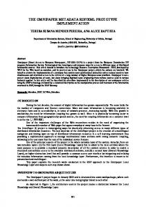
With reegard to data visualizzation, the SIK3D prrototype made m use off GLscene for 3D visualizzation. 3D visualizatio v n of buildinngs and ind dividual spaces are rep epresented on o UTM (Univerrsal Transfeer Mercator)) coordinatees. The objeects can be scaled up aand down, shift, and rotated on the dispplay windo ow accordinng to users interaction n. Informatiion window w is also availablle on requesst displaying g attrbutes oof selected geometries (figure 4). FFigure 4 sh hows that SIK3D applicationn is divided into two m main parts, namely n the visual and textual info ormation section. However, north n directtion and scaale informattion are not yet availabble at the mo oment.
Figure 4.. A screen cap pture of the SIK3D S as thee LADM impllementation prototype p
n done invollving four persons p who are: Landd Office staaff at the Usabilitty evaluatioon has been city of S Semarang, two t persons from the m managemen nt unit of Building of PPlaza Simpaanglima, one posstgraduate student. s Usability evalluation wass done through structuured interview after participants were asked a to testt the applicaation. The questions q in interview w was about : (i) level of easinness on thhe use of prorotype, (ii) effectiiveness of the protottype in faccilitating appartm ment spaces’’ managemeent includinng managem ment of own nership infoormation, (iii) about how thee prototypee gives cluees and indiccation of errrors in guiding the ussers compleeting the task, annd (iv) abouut satisfactio on to the useer interfacees. The responses were ranked from 1 to 5 that corr rresponds too very bad to o very goodd. The resullts of the tesst confirm thhat: the parrticipants response positivelyy (above 3,5 5) to all toppics of inqu uiries given except for point (iii) that was 3,20. Thhe results of o usability testing conffirm the useefulness of the prototyype.The parrticipants also enccouraged that the appliccation shouuld be impro oved furtherr.
473 Yanto Buudisusanto, Trrias Aditya and d Rochmad M Muryamto LADM Im mplementationn Prototype of 3D Cadastree Information System for Multi-Level M Apppartment in Indonesia I 5th Land A Administratioon Domain Mo odel Workshoop 24-25 Sepptember 2013, Kuala Lump pur, Malaysia
4. CONCLUSION From the development of a LADM implementation prototype for 3D Cadastre information system of multi-level appartment, it can be concluded that: 1. the basic classes of LADM (Land Administration Domain Model) can be accommodated for a rights registration system of the space (3D cadastre) applicable in accordance to the Law. No. 20 year 2011 on Appartment and Executive Order of Chief of National Land Office No. 1 Th. 2010 on service standards on land registration. LA_Party class comprises of Individual person, Legal Entity and Government Agencies as a right holder. LA_RRR Class is implemented as a type of space rights referring to the deed and related documents specifying the status of the rights of ownership. LA_BAUnit class refers to the procedures and rights registration system. LA_SpatialUnit class refers to a 3-dimensional object (apartment/ flats units); 2. this study successfuly implement a prototype of a desktop-based 3D cadastral information system by using the Delphi 7 Programming utilising PostGIS spatial databases that are created based on adoption of LADM basic classes; 3. The prototype, called SIK3D, has met the terms of service standards for strata title registration processing and visualization as well as to effectively link between the subjects and the property objects .
REFERENCES Anonim (2010) Head of National land Office’s Executive Order Number 1/2010 on Services Standards on Land Registration. Badan Pertanahan Nasional Republik Indonesia (BPN-RI). Anonim (2011) Law Number 20/2011 on Appartment . Aditya, T., Iswanto, F., Wirawan, A. & Laksono, D. P. (2011) 3D Cadastre Web: Prospects and Developments. In: Fendel, E., Oosterom P. van, Ploeger, H., Stoter, J., Streilein, A. & Tijssen, T. (Eds.) 2nd International Workshop on 3D Cadastres. Delft, FIG & TU Delft. Lemmen, C., Oosterom, P. van, Thompson, R., Hespanha, J. P. & Uitermark, H. (2010) The modelling of Spatial Units (parcels) in the Land Administration Domain Model (LADM). XXIV International FIG Congress. Sydney, FIG. Sucaya, I. K. G. A. (2009) Application and Validation the Land Administration Domain Model in a Real Life Situation (A Case Study in Indonesia). Geo-Information Management and Land Administration. Enschede, ITC.
474 Yanto Budisusanto, Trias Aditya and Rochmad Muryamto LADM Implementation Prototype of 3D Cadastre Information System for Multi-Level Appartment in Indonesia 5th Land Administration Domain Model Workshop 24-25 September 2013, Kuala Lumpur, Malaysia
BIOGRAPICHAL NOTES Yanto Budisusanto is currently a researcher in Cadastre and Land Policy Laboratory in Department of Geomatic Engineering, Civil Engineering and Planning Faculty, Sepuluh Nopember Institute of Technology (ITS), Surabaya, East Java, Indonesia. He completed his M.Eng degree in Geomatic Program Study from Gadjah Mada University (UGM), Indonesia. His research interest is in cadastre, spatial database and LIS/GIS. Trias Aditya is an Associate Professor at: the Department of Geodetic Engineering, Universitas Gadjah Mada (UGM), Indonesia. He completed his MSc and PhD degrees in Geoinformatics from ITC, the Netherlands. His research interests include interoperable LIS/GIS and Geovisualization and his latest research projects are 3D Cadastre, CollaborativeSpatial Data Infrastructure and Public Participation in Urban Disaster Risk Reduction. Rochmad Muryamto is currently an Assistant Professor in the Department of Geodetic Engineering, Faculty of Engineering, Gadjah Mada University (UGM), Indonesia. His research interest are in databases, spatial databases and GIS/LIS.
CONTACTS Yanto Budisusanto Department of Geomatics Engineering, Institut Teknologi Sepuluh November (ITS) Kampus ITS Sukolilo Surabaya INDONESIA Phone: +62-31-592486 Fax: +62-31-5929487 E-mail:
[email protected] Trias Aditya Department of Geodetic Engineering, Universitas Gadjah Mada (UGM) Yogyakarta INDONESIA Phone: +62-274-520226 Fax: +62-274-520226 E-mail:
[email protected] Rochmad Muryamto Department of Geodetic Engineering, Universitas Gadjah Mada (UGM) Yogyakarta INDONESIA Phone: +62-274-520226 Fax: +62-274-520226 E-mail:
[email protected] 475 Yanto Budisusanto, Trias Aditya and Rochmad Muryamto LADM Implementation Prototype of 3D Cadastre Information System for Multi-Level Appartment in Indonesia 5th Land Administration Domain Model Workshop 24-25 September 2013, Kuala Lumpur, Malaysia
5th Land Administration Domain Model Workshop 24-25 September 2013, Kuala Lumpur, Malaysia