Research Paper
GEOSPHERE GEOSPHERE; v. 13, no. 4
THEMED ISSUE: PLUTONS: Investigating the Relationship between Pluton Growth and Volcanism in the Central Andes
Thermomechanical modeling of the Altiplano-Puna deformation anomaly: Multiparameter insights into magma mush reorganization J. Gottsmann1,2, J. Blundy1,2, S. Henderson3, M.E. Pritchard1,4, and R.S.J. Sparks1,2 School of Earth Sciences, University of Bristol, Wills Memorial Building, Queens Road, Bristol BS8 1RJ, UK Cabot Institute and School of Earth Sciences, University of Bristol, Royal Fort House, Bristol BS8 1RJ, UK 3 Departamento de Geociencias, Universidad de los Andes, Cr 1 #18A-12, Edificio M1 Piso 3, Bogotá, Colombia 4 Department of Earth and Atmospheric Sciences, Cornell University, 2122 Snee Hall, 112 Hollister Drive, Ithaca, New York 14853, USA 1
doi:10.1130/GES01420.1
2
21 figures; 4 tables CORRESPONDENCE:
[email protected];
[email protected] CITATION: Gottsmann, J., Blundy, J., Henderson, S., Pritchard, M.E., and Sparks, R.S.J., 2017, Thermomechanical modeling of the Altiplano-Puna deformation anomaly: Multiparameter insights into magma mush reorganization: Geosphere, v. 13, no. 4, p. 1–24, doi:10.1130/GES01420.1. Received 20 August 2016 Revision received 24 February 2017 Accepted 11 April 2017
OL D G
ABSTRACT A 150-km-wide ground deformation anomaly in the Altiplano-Puna volcanic complex (APVC) of the Central Andes, with uplift centered on Uturuncu volcano and peripheral subsidence, alludes to complex subsurface stress changes. In particular, the role of a large, geophysically anomalous and partially molten reservoir (the Altiplano-Puna magma body, APMB), located ~20 km beneath the deforming surface, is still poorly understood. To explain the observed spatiotemporal ground deformation pattern, we integrate geophysical and petrological data and develop a numerical model that accounts for a mechanically heterogeneous and viscoelastic crust. Best-fit models imply subsurface stress changes due to the episodic reorganization of an interconnected vertically extended mid-crustal plumbing system composed of the APMB and a domed bulge and column structure. Measured gravity-height gradient data point toward low-density fluid migration as the dominant process behind these stress changes. We calculate a mean annual flux of ~2 × 10⁷ m3 of water-rich andesitic melt and/or magmatic water from the APMB into the bulge and column structure accompanied by modest pressure changes of 100 yr) residual deformation at Uturuncu. Episodic mush reorganization may be a ubiquitous characteristic of the magmatic evolution of the APVC.
OPEN ACCESS
INTRODUCTION
This paper is published under the terms of the CC-BY license.
The structural and chemical evolution of continental crust is intimately linked to igneous differentiation processes (e.g., Hawkesworth and Kemp, 2006). Both extensive recycling of material by crustal melting and new additions from the mantle contribute to crustal growth (e.g., Patchett et al., 1982).
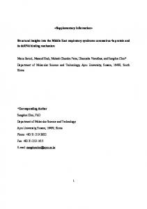
The Central Andes is a region where crustal thickening has occurred, leading to the formation of ~70-km-thick crust to the east of the Western Cordillera in the Altiplano-Puna region of southern Bolivia and northern Argentina (lat 18°S to 22°S; e.g., Zandt et al., 1994). Satellite remote sensing studies identified a large (>70 km wide) near circular area of surface deformation (Pritchard and Simons, 2002) centered on Cerro Uturuncu (22.270˚S, 67.180˚W), a 6008-m-high Pleistocene dacitic volcano (e.g., Sparks et al., 2008) in the Altiplano-Puna volcanic complex (APVC; de Silva, 1989). The mean maximum deformation rate of ~1 cm/yr has been ongoing from 1992 to 2011 (Fialko and Pearse, 2012; Henderson and Pritchard, 2013). As part of the central volcanic zone of the Andes, the APVC is interpreted as the volcanic expression of a crustal magmatic system that between 10 and 1 Ma fed episodic and cyclic silicic ignimbrite flare-ups (e.g., Salisbury et al., 2011). The explosive eruption of ~15,000 km3 of magma across the APVC formed numerous large collapse calderas (de Silva and Gosnold, 2007). Several geophysical methods have detected anomalies under the APVC that are interpreted as the Altiplano-Puna magma body (APMB) (see Table 1 for summary and references). The deformation anomaly covers a substantial part of the APVC and, although centered on Uturuncu (located ~100 km to the east of the active Holocene volcanic arc), it also includes several other Pleistocene and older volcanic edifices within an area of ~31,500 km2 (Fig. 1). Several explanations have been proposed for the deformation anomaly, including the pressurization of subsurface cavities (as a proxy for magma reservoirs) located at various crustal depths above, within, and below the APMB, and complex interactions between multiple magmatic systems located at upper to lower crustal levels (Pritchard and Simons, 2002; Sparks et al., 2008; Hickey et al., 2013). Alternatively, Fialko and Pearse (2012) proposed the ascent of a magmatic diapir from the APMB to explain a broad moat of relative ground subsidence surrounding a central area of ground uplift (Figs. 1–3). Here we integrate and interpret recent results from new geophysical, geodetic, geomorphic, and petrological studies conducted on and around Uturuncu including part of the PLUTONS project (probing Lazufre and Uturuncu together; http://plutons.science.oregonstate.edu/about; a collaboration core-funded by the U.S. National Science Foundation and the U.K. Natural
© 2017 The Authors
GEOSPHERE
|
Volume 13
|
Number 4
Gottsmann et al.
|
Mush reorganization at Uturuncu
1
Research Paper TABLE 1. COMPILATION OF RECENT STUDIES AND AVAILABLE DATA TO INFORM THE NUMERICAL MODEL Technique
Key findings
Available data for model input
Reference
Magnetotellurics
Low electrical resistivity anomaly at ~15 km depth below sea level with upper surface of 8–13-km-wide vertical anomaly shallowest beneath Uturuncu
Size and geometry of anomalous structures
Schilling et al. (2006); Comeau et al. (2015, 2016)
Gravimetry
Approximately 12–24 km wide, vertically elongated (8–12 km high), low-density structures rooted at the top of the APMB at ~15 km below sea level
Size and geometry of anomalous structures
del Potro et al. (2013b)
Seismology
Low seismic velocity zone at depths of between 4 and 25 km below sea level; seismic brittle-ductile transition at around sea level
Three-dimensional crustal shear wave velocity; depth of brittle-ductile transition
Ward et al. (2014); Jay et al. (2012); Chmielowski et al. (1999); Zandt et al. (2003)
Petrology
Preeruptive dacite storage pressures at Uturuncu to 100 ± 50 MPa at 870 °C
Crustal temperature profile in mush column and APMB
Muir et al. (2014b)
Geodesy
Approximately 150-km-wide displacement field with central Surface velocity and spatiotemporal InSAR line of sight velocities of ~1 cm/yr between May 1992 evolution of deformation and January 2011; moat of subsidence surrounding central area of uplift; leveling data indicates uplift since 1960s; global positioning system data indicate slower uplift rate between 2010 and 2015
Fialko and Pearse (2012); Henderson and Pritchard (2013); del Potro et al. (2013a); Blewitt et al. (2016)
Geomorphology
Absence of sustained residual long-term deformation
Perkins et al. (2016)
Null result for residual ground deformation at time, t > 100 yr
Note: See text for details on numerical model. APMB—Altiplano-Puna magma body.
Environment Research Council. We present a numerical deformation model to explain the observed ground deformation in the context of the multiparameter studies of the project.
BACKGROUND AND MULTIPARAMETER CONSTRAINTS Many novel findings on the subsurface architecture and petrology of the APMB as well as Uturuncu volcano are presented in this themed Geosphere issue (and elsewhere) as a result of the PLUTONS project. Table 1 summarizes the key results that are employed to inform the numerical models developed here.
Geophysics Geophysical imaging techniques (seismic, gravimetric, and magnetotelluric) coupled with three-dimensional (3D) data inversion identify a broad region of low seismic velocity, low density, and low electrical resistivity at mid-crustal levels (≤20 km depth; Comeau et al., 2015; del Potro et al., 2013a; Ward et al., 2014). The joint inversion of surface wave dispersion and receiver functions (Ward et al., 2014) depict a voluminous, 11-km-thick low seismic velocity zone with a diameter of ~200 km and a top at depths of between ~9 and 30 km beneath the ground surface (4–25 km below mean sea level). Inverse models
GEOSPHERE
|
Volume 13
|
Number 4
Gottsmann et al.
|
of static potential field data image a topographically heterogeneous upper surface to this large body. Beneath Uturuncu a vertically elongated (column like) structure with a radius of between 6 and 12 km extends a further 8–10 km above the mean depth of the APMB (Comeau et al., 2015; del Potro et al., 2013a). Several vertically elongated low-density and high-conductivity structures connect the low velocity zone with near-surface crustal levels below composite volcanic edifices of the APVC.
Petrology The piecemeal assembly and eruption of chemically distinct batches of dacite magma from a chemically heterogeneous magma system beneath Uturuncu dominated the eruptive history during its protracted activity from 1050 to 250 ka (Muir et al., 2015, 2014a). Experiments determined the preeruptive dacite storage pressures at Uturuncu to be 100 ± 50 MPa (Muir et al., 2014b) at ~870 °C (1143 K). Isotopic data from the Uturuncu dacites indicate a mixture of crustal-derived and differentiated mantle–derived melts (Michelfelder et al., 2014). Andesitic and basaltic andesitic enclaves in Uturuncu lavas and in silicic ignimbrites of the APVC (Michelfelder et al., 2014) are interpreted as aliquots of the least evolved resident magmas in the APMB entrained into the volumetrically dominant, silica-rich dacite magmas (Sparks et al., 2008). The mafic magmas have less radiogenic strontium and more radiogenic neodymium isotopes than associated dacites (Michelfelder et al., 2014) and are thought to be
Mush reorganization at Uturuncu
2
Research Paper 69°W
68°
67°
66°
21°S
21°
22°
22°
23°
23°
24°
24°
69°
68°
67°
66°
Figure 1. Map view of study region in the Altiplano-Puna region of southern Bolivia. Red star marks center of vertical uplift (lat 22.270°S; long 67.233°W) on the western slope of Uturuncu volcano; red solid circle marks extent of uplifting region (radius of ~40 km); and red dashed circle marks extent of peripheral subsidence (radius of ~75 km) determined from InSAR (interferometric synthetic aperture radar) profiles in Figure 2. The dashed black line outlines the spatial extent of the Altiplano-Puna volcanic complex (APVC). The spatial extent of the 2.5 km/s velocity contour of the S wave velocity model at 20 km below sea level presented in Ward et al. (2014) is similar to the footprint of the InSAR anomaly, as shown by the solid white ellipse. Black solid lines mark international borders, yellow triangles mark Holocene volcanic centers along the active volcanic front, and green triangles mark older volcanic centers of the APVC. Elevations in the digital elevation model are given in m above sea level.
the heat source for crustal anatexis (Muir et al., 2015). These observations and interpretations are consistent with the hot zone concept of Annen et al. (2006), whereby repeated incursions of hot mantle-derive magmas into the lower or mid-crust drive differentiation by a combination of crystallization and anatexis. Recent high-pressure electrical conductivity and petrological experiments (Laumonier et al., 2017) provide further insights into magma chemistry in the APMB. They show that the high electrical conductivity (~1 S m–1) of the APMB, while maintaining the low melt fractions defined seismically (Ward et al., 2014), can be matched by andesitic melts with high water contents (7–10 wt%). Note that an alternative scenario, wherein the APMB contains dacite melt containing the observed dissolved water content of ≤4 wt%, cannot explain the high electrical conductivity of the APMB as imaged by Comeau et al. (2015). To do so, a substantially higher (by at least a factor of 1.5) melt fraction compared to
GEOSPHERE
|
Volume 13
|
Number 4
Gottsmann et al.
|
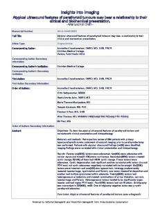
Figure 2. Azimuthally averaged profiles for several InSAR (interferometric synthetic aperture radar) data sets. LOS—line of sight. For a map view of averaged region see Figure 3. Blue line is representative profile of combined stack of ERS and Envisat satellite data track 282 spanning 1995–2011 (Henderson and Pritchard, 2013). The green profile is a stack of only Envisat data from the same track spanning 2003–2010. The cyan profile is a stack of Envisat ascending track 89, and for comparison the purple profile (ENV_T89) is a stack spanning 2003–2010 from the independent analysis of Fialko and Pearse (2012).
the seismically constrained fraction would be needed (Ward et al., 2014). Phase equilibrium experiments on andesite enclaves from Uturuncu show that the observed phenocrysts assemblage and characteristic calcic plagioclase composition require pressures in the range 500–700 MPa, magmatic temperatures of 970 °C (1243 K) and dissolved H2O contents of 8–10 wt%, consistent with the conductivity studies (Laumonier et al., 2017). Together, the geophysical and petrological data support an APMB composed of 8–30 vol% water-rich andesite melt dispersed in a solid matrix. Mixing of these andesitic melts with crustal melts atop the APMB gave rise to the hybrid dacites at Uturuncu and elsewhere in the APVC (Fig. 4).
Thermal The extensive magmatism and volcanism over the past 15 m.y. in the Altiplano region is proposed to have left a thermal fingerprint in the upper crust beneath the APVC (de Silva and Gosnold, 2007). The bottom of the present-day seismogenic zone, inferred to be the brittle-ductile transition zone (BDTZ), around Uturuncu volcano is located at depths of 4.5–10 km beneath the ground
Mush reorganization at Uturuncu
3
Research Paper mum of 1.05 ± 0.1 cm/yr between May 1992 and January 2011, whereas LOS subsidence occurred at a maximum of 0.22 cm/yr (Henderson and Pritchard, 2013). The axis-symmetric uplift has a radius of 35–40 km, and peripheral subsidence extends out to 70–75 km. Reoccupation of a nearby leveling line using the global positioning system (GPS) shows that the ground deformation has been active since at least 1965 at rates comparable to the satellite-derived deformation (del Potro et al., 2013b), but continuous GPS data collected near the center of deformation that span 2010–2015 (Appendix Fig. A1 in Appendix 1) indicate that uplift has slowed to a rate of ~0.24 ± 0.19 cm/yr (Blewitt et al., 2016).
Geomorphology Geomorphological investigations of shorelines and river terraces reveal an absence of sustained residual long-term and long-wavelength deformation at the geodetically observed rates (Perkins et al., 2016), and identify the onset of Uturuncu’s present deformation phase as no more than 100 yr ago. These observations indicate that the recent deformation is a transient pulse.
MODELING RATIONALE AND MODEL PARAMETERIZATION
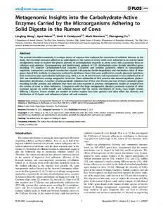
Figure 3. InSAR (interferometric synthetic aperture radar) stacks with locations of profiles shown in Figure 2. LOS—line of sight. Wedges show the location of profiles from Figure 10. Azimuthally averaged profiles in Figure 2 combine the four wedges to the west and four to the east of the center of deformation. The horizontal black lines show the location of the east-west swath profile used to determine vertical and radial components of deformation. Dotted lines mark international borders.
surface and is shallowest directly beneath Uturuncu (Sparks et al., 2008; Jay et al., 2012; Keyson and West, 2013). Pleistocene eruptions of Uturuncu produced dacites having depths of last equilibration before eruption (see following) that coincide with the present-day BDTZ (Muir et al., 2014b). An estimate of the current temperature distribution between the APBM and the BTDZ, constrained by petrological, experimental, and geophysical data, is summarized in Figure 4.
Satellite and Ground-Based Geodesy Figure 1–3 show the deformation field around Uturuncu volcano from InSAR (interferometric synthetic aperture radar) observations between 1992 and 2011. A broad moat of ground subsidence is discernible around uplift centered on Uturuncu. Velocities of line of sight (LOS) uplift have been calculated at a maxi-
GEOSPHERE
|
Volume 13
|
Number 4
Gottsmann et al.
|
The geophysical and petrological data imply a mechanically heterogeneous crust, including hot and partially molten regions that will modulate subsurface stresses and strains. This inference has major implications for geodetic modeling. Conventional analytical deformation models that assume crustal elasticity and mechanical isotropy are not suited to explain the observed ground deformation over multiple decades. Here we develop a coupled thermal and geomechanical finite-element model that accounts for inelastic crustal behavior using multiphysics capabilities of the commercial finite-element code COMSOL Multiphysics v 5.1 (https://www.comsol.com/release/5.1). Our modeling approach is guided by a number of hypotheses and assumptions constrained by the following observations. 1. The observed ground deformation can be explained by dynamics within the geophysically imaged anomalous structures in the middle and upper crust beneath Uturuncu. 2. The APMB mechanically decouples the upper and middle crust (≤30 km depth from surface) from the lower crust. Processes in the lower crust do not contribute directly to the deformation signature of the APVC. 3. Petrological, experimental, and geophysical data constrain the current temperature distribution between the APMB and the BDTZ (Fig. 4). 4. The APMB is composed of water-rich andesite melt dispersed in a solid matrix. 5. Time-dependent inelastic behavior of a hot upper crust modulates subsurface strain. 6. The net deformation over time scales of centuries is zero.
Mush reorganization at Uturuncu
4
Research Paper Figure 4. Summary of geophysical, geochemical, and petrological constraints used to construct the thermal structure of the numerical model. Depth (z) is given in kilometers beneath the summit of Uturuncu volcano (z = 0 km). The lithostatic pressure is given in MPa and derived from Equation 6 using ρc × g × z (g = gravitational acceleration). Temperature is given in both K (bottom) and °C (top). Magnetotelluric (MT) and petrological studies envisage the Altiplano-Puna magma body (APMB) to be composed of as much as 25 vol% andesitic melt with ~9 wt% dissolved H2 O dispersed in a solid crystal matrix at a temperature of 1243 K (Comeau et al., 2015; Laumonier et al., 2017). The depth range of the APMB as imaged by MT data is highlighted in the gray box and marked C2015 (i.e., Comeau et al., 2015). Here we follow the hypothesis that the dacites erupted at Uturuncu are sourced by mixing of the andesitic melts with anatectic crustal melts on top of the APMB. The depth range of the seismic image of the APMB presented in Ward et al. (2014) and marked W2014 in the gray box likely corresponds to these waterundersaturated hybrid dacite melts overlying the MT APMB. Petrological experiments constrain dissolved water contents in the dacite melts at ≤4 wt%. The solidus temperature of water-saturated dacite is ~933K at 330 MPa; therefore, no melt is present at lower pressures. The seismic brittle-ductile transition zone (BDTZ) is currently located between 4 km below sea level and sea level (i.e., at z = –6 km) (Jay et al., 202), at which depth we invoke a temperature of ~660 K. The youngest dacites of Uturuncu volcano erupted 250 ka ago, last equilibrated at pressures of 100 ± 50 MPa and a temperature of 1143 K (Muir et al., 2014a, 2014b, 2015), and were likely sourced by adiabatic ascent from the top of the APMB. The BDTZ has likely migrated downward since the last known eruptions of Uturuncu. In our numerical model the geotherm beneath Uturuncu volcano (blue broken line) is a combination of (1) a geotherm through Uturuncu’s plumbing system (for –6 km > z > –19.5 km) constrained by a linear fit through the temperature fields of the BDTZ, the water-saturated dacite solidus, the hybrid water-undersaturated dacite on top of the MT APMB and the andesite melts of the APMB; (2) an isothermal APMB at 1243 K; and (3) a nonlinear geotherm above the BDTZ where the temperature distribution is modulated by the presence a reference geotherm (shown by broken black line; see text for details). C3 marks the depth and likely temperature field of electrical conductor #3 identified in Comeau et al. (2016). This field is intersected by the vapor and liquid (V + L; coex.—coexisting) solvus of the H2 O-NaCl system (Driesner and Heinrich, 2007). The two surfaces shown correspond to either lithostatic (lithostat.) or hydrostatic (hydrostat.) stress conditions and mark the maximum pressures under which vapor and liquid can separate from a supercritical fluid. In this context conductor C3 is interpreted as rocks above the BDTZ containing a brine and vapor mixture.
Initial and boundary conditions that are informed by the available multiparametric constraints on the subsurface architecture of the APVC are described in the following and illustrated in Figures 5–7. Model parameters are summarized in Table 2.
Solid Mechanics: Initial and Boundary Conditions We solve for stresses and strains by invoking a 2D axisymmetric model with radial distance 0 km ≤ r ≤ 125 km and depth 0 km ≥ z ≥ –35 km and solving for ~200,000 degrees of freedom using ~24,000 mesh elements with element size between 1.6 and 2670 m (Fig. 5). The top of the modeling domain, at z = 0 m, represents the summit of Uturuncu volcano (at 6008 m above sea level). Thus to convert to height and depth values relative to mean sea level, a value of 6 km needs to be added to the z values. The lateral extent of the modeling domain is constrained by the size of the seismically imaged APMB and the available spatial InSAR coverage and by computational cost. The 250 km width of the axisymmetric model captures the primary features imaged by the static and dynamic geophysical observations while allowing for rapid convergence of the simulation toward a single solution.
GEOSPHERE
|
Volume 13
|
Number 4
Gottsmann et al.
|
The lower boundary of the modeling domain is at z = –35 km (29 km below sea level). We chose this model dimension in line with assumptions 1 and 2. A 2D axisymmetric model is representative of the primary geophysical observations. Although there are some 3D variations, they are of secondary importance. The upper model boundary is free of displacement constraints, while the lower and right boundaries have roller conditions that allow free lateral, but no vertical, displacement. The left boundary (r = 0) is the symmetry axis. Four different model domains with different mechanical and thermal properties are initially invoked, i.e., volcanic edifice, crust, column, and APMB (Fig. 5). Pressure changes are prescribed to the column and APMB domains by applying arcuate boundary loads, which induce a differential stress field from equilibrium conditions. Mechanical and thermal properties for all domains are given in Table 2.
Volcanic Edifice The volcanic edifice of Uturuncu is approximated by a trapezoidal shape, with a 120-m-wide top at z = 0 km and a basal width of 9 km at z = –1.5 km. This geometry simulates a prominence of the edifice of 1.5 km above the mean ele-
Mush reorganization at Uturuncu
5
Research Paper
Figure 5. Illustration of the initial twodimensional axisymmetric finite element model composed of four domains: (1) the Uturuncu edifice (summit at z = 0 km), (2) the crust (–1.5 km < z < –35 km), (3) the column, and (4) the Altiplano-Puna magma body (APMB). Imposed boundary conditions are (1) the upper surface is free to deform and (2) roller boundaries are applied to the bottom and right. The base of the model has an inward boundary heat flux Q. A fixed temperature TAPMB is imposed on the APMB boundaries. The vertical column has a depth-dependent temperature profile (see Fig. 4). Boundary pressure (dP) loads are applied on the column and APMB. Model parameters are given in Table 2. InSAR—interferometric synthetic aperture radar; r—symmetry axis.
vation of the Altiplano at 4500 m above sea level (i.e., sea level is at z = –6 km). Uturuncu’s edifice is made up of dacitic lava flows and we characterize it by a Young’s modulus of 20 GPa and density of 2350 kg/m3.
The fit represents a reasonable approximation to the findings by Lucassen et al. (2001) and Kösters (1999) as well as the 1s upper bound of the data from Equation 3. We obtain the Young’s modulus (E) via
Crust
E (Pa) = vp2rc (1 + n)(1 – 2n)/(1 – n),
We invoke mechanical heterogeneity of the crust by using 3D shear wave velocities (vs ), mineralogical data, and density data to derive elastic constants for subsolidus regions of the model. First we convert the vs data presented in Ward et al. (2014) to p wave velocity data (vp ) following Brocher (2005): vp (km/s) = 0.9409 + 2.0947vs – 0.8206vs2 + 0.2683vs3 – 0.0251vs4.
(1)
Next we calculate Poisson’s ratio (n) and density (r) via: n = 0.5[(vp /vs )2 – 2]/[(vp /vs )2 – 1],
(2)
r (kg/m3) = 1661.2vp – 472.1vp2 + 67.1vp3 – 4.3vp4 + 0.106vp5.
(3)
and
In order to convert the 3D mechanical data for parameterization of the solid mechanics to the 2D axisymmetric models, we use a third-order polynomial fit to the density data calculated in Equation 3, the mineralogically derived densities presented in Lucassen et al. (2001), and the density model reported in Kösters (1999). The resultant fit (Fig. 6A) is rc (kg/m3) = 2425 – 0.04 × z – 1.9 × 10⁻⁶ z 2 – 3.1 × 10⁻¹¹ z 3.
GEOSPHERE
|
Volume 13
|
Number 4
Gottsmann et al.
|
(4)
(5)
where vp is in meters/second, and use a third-order fit to the data to parameterize the crustal Young’s modulus (Ec) as a function of depth via: Ec (Pa) = 3.6 × 10¹⁰ – 6.5 × 10⁶ × z – 322 × z 2 – 0.005 × z 3.
(6)
In the absence of relationships between static (on time scales and amplitudes of observed geodetic ground deformation spanning years to millennia) and dynamic (on time scales and amplitudes of seismic deformation) mechanical properties for the Andean crust, we employ the seismically derived dynamic values. The static Young’s modulus may be a factor of a few lower than the dynamic modulus (Gudmundsson, 1983). Use of dynamic properties will therefore yield conservative values for pressure transients toward the upper bound of what may be required to explain the data. APMB. The laterally extensive main body of the APMB has its top at z = –19.5 km (based on magnetotelluric data; Comeau et al., 2016), a radius of 100 km (based on seismic images; Ward et al., 2014), and a thickness of 10– 20 km (Ward et al. 2014; Comeau et al., 2016). The density of the APMB at 1243 K and 500 MPa is calculated as 2630 kg/m3, accounting for 25 vol% (Ward et al., 2014) of andesitic melt containing 9 wt% of water (density = 2110 kg/m3) within a solid crystal matrix of density 2800 kg/m3. The density of hydrous melts at these conditions is calculated using the parameterization of Ochs and Lange (1999); the solid matrix density corresponds to a quartz gabbro calculated after
Mush reorganization at Uturuncu
6
Research Paper
A sea level
BDTZ z (km)
Figure 6. (A) Crustal density derived from data presented in Ward et al. (2014). (B) Young’s modulus derived from data presented in Ward et al. (2014). Broken lines represent mean average values and shaded areas bracket upper and lower 1σ error bounds. The dotted lines in A mark the calculated densities for the grand mean Andean crustal composition by Lucassen et al. (2001). LC1 is based on an initial 1 K/MPa geotherm between 0.4 and 0.7 GPa followed by a geotherm of 0.16 K/MPa; LC2 is based on a 0.5 K/MPa between 0.8 and 1 GPa. Mineralogy employed to calculate the density data: quartz 31.6 vol%; plagioclase 35.6 vol%; sanidine 17.6 vol%; garnet 3.1 vol%; see Lucassen et al. (2001) for details. The broken lines labeled KR and KC correspond to two sections through the subsurface density model beneath the Altiplano as reported in Kösters (1999). Red bold lines in A and B are third-order fits used for the parameterization of the mechanical properties of the crust. See text for details and fit parameters and Figure 5 for identification of the crustal domains in the finite element model. The brittle-ductile transition zone (BDTZ) beneath Uturuncu (Jay et al., 2012; Keyson and West, 2013) is shown for reference. Depth, z, is given in kilometers below the summit of Uturuncu.
B
z (km)
sea level
Hacker and Abers (2004). The mechanical properties of the APMB domain are summarized in Table 2. Column. The initial shape and size of the vertical column are determined by the gravity and magnetotelluric data (del Potro et al., 2013a; Comeau et al., 2015). As initial conditions (Figs. 5 and 7) we invoke a cylindrical column with a 6 km radius (a value consistent with the crustal resistivity and density contrast images) that is rooted in the APMB and extends to a depth of z = –6 km (i.e.,
GEOSPHERE
|
Volume 13
|
Number 4
Gottsmann et al.
|
sea level). The top of the column matches the upper bound of reported seismic brittle-ductile transition depth of between 4.5 and 10 km below the Altiplano (Jay et al., 2012; Keyson and West, 2013; see Fig. 6 and following discussion of thermal boundary conditions). The final shape, orientation, and size of the column and APMB are explored in an iterative forward-modeling approach to fit the observed ground deformation data. We attribute a density of 2580 kg/m3 to the column based on an average density contrast of –120 kg/m3 (del
Mush reorganization at Uturuncu
7
Research Paper
A
B
Figure 7. (A) Plumbing system geometry (Altiplano-Puna magma body, bulge, column; see Fig. 5 for explanation) and resultant temperature distribution (in K) of one of the best-fit models; z is depth beneath summit of Uturuncu. (B) Temperature-dependent viscosity and relaxation (relax.) time relationship of the viscoelastic crustal model.
Potro et al., 2013a) with the crustal density according to Equation 5 between z = –6 and z = –19.5 km. As we show herein, due to thermal constraints and geophysical observations the column is unlikely to contain partial melt except in its deepest part, where the temperature is thought to be above the watersaturated dacite solidus (~933 K). Comeau et al. (2016) invoked the presence of saline magmatic fluids in the upper parts of the column at depths of approximately sea level to explain its electrical resistivity of 3–7 Ω·m (Fig. 4). Various
GEOSPHERE
|
Volume 13
|
Number 4
Gottsmann et al.
|
volumetric combinations of country rock, magma, fluids, and pore space are consistent with the resistivity and bulk density observations (for further discussion see Comeau et al., 2016; del Potro et al., 2013a). Only the deduced bulk density of the column significantly influences model results via the calculation of lithostatic stresses and resultant stress differentials. The combination of different material fractions for given bulk density has little influence on the model outputs.
Mush reorganization at Uturuncu
8
Research Paper TABLE 2. MODEL PARAMETERS Parameter
Description
Value
Unit
Ad
Dorn parameter
109
Pa s
120,000
J/mol
H
activation energy
µ0 = µ1
constants
R
gas constant
8.314
J/(mol K)
g
gravitational acceleration
9.81
m/s2
υc
Poisson’s ratio of host rock
0.237
υm
Poisson’s ratio of APMB and magmatic column
Ec
crustal Young’s modulus
Equation 6 (see text)
Pa
ρc
crustal density
Equation 4 (see text)
kg/m3
Ee
Edifice Young’s modulus
2∙1010
Pa
ρe
edifice density
2350
kg/m3
0.5
0.07
Ginst
instantaneous crustal shear modulus
E/[2(1 + υc)]
Pa
ρAMPB
APMB density
2630
kg/m3
ρmagcup
magmatic column density
2580
kg/m3
k
thermal conductivity
3.0
W/(m K)
Kh
hybrid column bulk modulus
2.5∙109
Pa
Ka
APMB and magmatic column bulk modulus
Kc,
crustal bulk modulus
2∙1010
Pa
Ec /3(1 – 2υc)
Pa
cp
heat capacity
1000
J/K
dT/dz
thermal gradient
0.03
K/m
Tc
column temperature
–0.043∙z + 400
K
TAPMB
APMB temperature
1243
K
Q
lower domain boundary heat flux
0.09 W/m2
W/m2
Note: APMB—Altiplano-Puna magma body.
Body Load The models account for lithostatic stresses and gravitational loading, which is invoked by a body load applied to all model domains. In order to balance the gravitational forces, we invoke initial stress conditions on all modeling domains using the cyclic stress loading–compensation sequence (Gottsmann and Odbert, 2014). All domains are consequently free of any significant residual stresses and strains prior to applying the boundary conditions. The residual deformations in all domains at the end of this sequence are negligible and ~10–10 m.
Heat Transfer Initial and Boundary Conditions The following thermal boundary conditions are invoked. The surface is set to 275 K and the lower boundary at z = –35 km has an inward heat flux of 0.09 W/m2. Ignoring radiogenic heat production and assuming constant thermal
GEOSPHERE
|
Volume 13
|
Number 4
Gottsmann et al.
|
conductivity, a reference geotherm of 30 K/km is thus obtained (Jaupart and Mareschal, 2009). This reference geotherm is maintained in the model only along the right-side boundary, because the temperature distribution in most of the modeling domain it is strongly influenced by the magmatic plumbing system (APMB and column). We invoke a temperature of 1243 K for the APMB, corresponding to the liquidus temperature of andesite inclusions at Uturuncu as determined by petrological observations and experiments (Sparks et al., 2008; Laumonier et al., 2017). This temperature is consistent with the supposition that the APMB comprises wet andesite melt in a solid matrix, overlain by a partially molten layer containing dacite melt (see Fig. 4). While other deeper storage regions from which andesite has been sourced may exist beneath Uturuncu, our assumption is consistent with the available petrological, geochemical, and geophysical constraints (Michelfelder et al., 2014; Muir et al., 2015; Laumonier et al., 2017). The top of the column at z = –6 km marks the upper bound of the BDTZ, for which we set a temperature of T = 387 °C (660 K) (Priestley et al., 2008). This depth corresponds to the upper bound of experimentally determined confining pressures of 100 ± 50 MPa of pre-eruptive
Mush reorganization at Uturuncu
9
Research Paper magma storage conditions for Uturuncu dacites (Muir et al., 2014b). However, the temperature is considerably lower than the pre-eruptive storage temperature of the last erupted dacites of Uturuncu at 870 °C (1143 K; Muir et al., 2014a) due to secular cooling of the shallow magmatic reservoir over the past 250 k.y. (Fig. 4). To prescribe thermal boundary conditions to the entire subvolcanic plumbing system at Uturuncu, we reconcile the petrological temperature and pressure data shown in Figure 4 by a linear geotherm of 43 K/km between sea level and the top of the APMB. The resultant temperature distribution across all modeling domains is shown in Figure 7A.
Viscoelasticity The deduced thermal structure beneath the APVC implies that the mechanical response of the middle and upper crust at low strain rates is time dependent. Here we adopt viscoelastic mechanical behavior using a generalized Maxwell model (for details see Del Negro et al., 2009; Hickey and Gottsmann, 2014). This parameterization consists of one elastic branch, where the mechanical response of the medium is governed by its shear modulus, G = G0 × m0,
(7)
and one viscoelastic branch with a characteristic relaxation time t0 = h/(G0m1).
(8)
G0 is E/2(1 + n), h is the viscosity and m1 = m0 = 0.5 are fractional components of the shear modulus; h is parameterized by the Arrhenius approximation h = Ae(H/RT),
DEFORMATION DATA InSAR Tracks and Representative Profiles of Deformation Independent analyses of all available stripmap C-band InSAR data for Uturuncu from the ERS-1/2 and Envisat satellites, spanning May 1992 to January 2011, were presented in Fialko and Pearse (2012) and Henderson and Pritchard (2013). However, there are differences in the data analyzed. Both papers analyzed tracks 282, 10 (both beam 2 for Envisat), and 89 (beam 6 from Envisat only), but Fialko and Pearse (2012) included ScanSAR (scanning synthetic aperture radar) mode Envisat data for track 89, giving additional observations, and Henderson and Pritchard (2013) also included track 3 (beam 2 for Envisat). Models here are compared against stacked InSAR data from these two studies using all four tracks: two ascending tracks (89 and 3), and two descending tracks (282 and 10). This data set provides maps of average sur-
|
Volume 13
|
Number 4
U LOS = a × Uz + b × Ur × cosb + c × Ur × sinb,
(10)
where the coefficients a, b, and c map vertical, east-west, and north-south displacement components, respectively, into the radar LOS (e.g., Wright et al., 2004). Because of the north-south orbits of InSAR satellites, north-south motions are not well mapped to LOS: for example,