Proc. Fla. State Hort. Soc. 119:107-119. 2006.
REAL-TIME INTERNET-PDA-BASED SURVEY AND MODELING SYSTEMS FOR AGRICULTURAL INSECTS AND DISEASES: INTEGRATED FRUIT FLY, CITRUS CANKER AND GREENING SURVEYS STEVEN ROGERS1*, HERBERT N. NIGG2, ISOBEL CLARK3, DANIEL S. HART4, REZA EHSANI2**, DAVE L. BROCK5, AND EDWARD W. SCHUSTER5 1 Ecostat, Inc. P.O. Box 237 Highland City, FL 33846 2University of Florida, IFAS Entomology and Nematology Department Citrus Research and Education Center 700 Experiment Station Road Lake Alfred, FL 33850 3
Geostokos, Limited, Alloa Whins Road Alloa FK10 35A, Central Scotland 4Serveon, Inc. 1401 Silverside Road, Suite C Wilmington, DE 19810 5
The Data Center at MIT Massachusetts Institute of Technology Building 35, Room 234 Cambridge, MA 02139 Additional index words. Ceratitis capitata, Eriobotrya japonica, Liberobacter asiaticum, Persea americana, Psidium spp., Xanthomonas axonopodis, Ag Certification Network, Caribbean Fruit Fly Free Protocol, citrus variegated chlorosis, computerassisted sampling, expert system, geostatistics, guava, GPS, handheld PDA, huanglongbing, logistic growth, loquat, Mediterranean fruit fly, M Language, pest risk assessment, trade barriers, Universal Scouting Model Abstract. This paper introduces an Internet-PDA-based spatiotemporal survey and modeling service called, the “Ag Certification Network”. This service was originally intended for the Caribbean Fruit Fly (Anastrepha suspensa Loew) Free Protocol certification program. Due to certain urgencies in tracking pest prevalence in Florida, the service was amplified to accommodate all important citrus insects and diseases, including citrus canker and greening diseases. One challenge was how this information can automatically be related to data from distributed global information networks, including other agricultural pest data acquisition systems. Our solution makes use of a universal algorithm for acquiring, aligning, and analyzing information from any agricultural crop-pest domain. Its foundaThis project was supported in part by a grant from the United States Department of Agriculture Foreign Agricultural Service, Technical Assistance for Specialty Crops, TASC Agreement #04010 through the sponsorship of the Indian River Citrus League. Cooperative assistance was provided by the Indian River Citrus League, the Florida Department of Agriculture and Consumer Services and George Jenkins High School. *Corresponding author; e-mail:
[email protected] **Agricultural and Biological Engineering Department
Proc. Fla. State Hort. Soc. 119: 2006.
tion is a centralized data representation allowing relationships from input sources separated by structure or distance to be explored in real-time through mapping, mathematical modeling, and OLAP cube reporting. These features are valuable to growers because retrospective analyses against financial data become easier, and insects and diseases can be tracked in realtime to facilitate better management decisions. They are also useful to regulators who certify crops for sale to foreign or domestic markets. The features can also help researchers who wish to produce statistical analyses in real-time rather than wait until the end of an experiment to generate their results. We present our system architecture and show how observational information is acquired by centrally-located servers using handheld PDA computers. First-year mathematical and geostatistical modeling results suggest Caribbean Fruit Fly populations can be described by a logistic function and occur with an approximate 30-mile range of influence. This study utilizes a new computer language in development at MIT (the “M” Language) that provides an interoperable data organization and modeling environment. The application of M supports automatic alignment and modeling of information from different agricultural, ecological, environmental, and financial domains. A commercial-level Ag Certification Network Pilot Trial scheduled to begin 1 September 2006 was recently ratified by the Indian River Citrus League. Information of the type collected in this trial could be useful in any surveillance program, including sentinel plot monitoring, grower self-surveys, pre-harvest inspections, laboratory-based passive tracking programs (e.g., the National Plant Diagnostic Network (NPDN), team-based research projects where data sharing is critical, and coordinated international insect and disease traceability programs.
Six years ago, Rogers (2000) described an integrated Internet-PDA-based system to collect and analyze fruit fly and canker surveillance information. Using this approach, canker inspections could be “piggybacked” onto fruit fly certification programs, reducing the need for multiple forms and survey protocols. Rogers’ integrated survey system was based on a prior architecture he developed in the 1990s for the centralized Internet-based analysis of survey data from any agricultural crop-pest domain (Rogers, 1995). In 1992, Rogers described an artificial intelligence-based platform, ECOSTAT IV, to process real-time pest survey data in modeling and expert decision support systems (Rogers, 1992), such as those used for collecting citrus rust mite population data (Rogers et al., 1993). Though these precedents were established in the literature for universal Internet-based citrus pest surveying and modeling, it was not until spring 2006 that this technology became a focus of industry-wide discussion. This was due to the urgent need for accurate and timely information to use in pest risk assessment and global marketing programs. Citrus Pest Inspection and Certification Programs in Florida. Florida citrus growers face important phytosanitary issues in shipping fruit to domestic and foreign markets. Important trade barrier pests include Mediterranean fruit fly (Ceratitis capitata Wiedemann), Caribbean fruit fly (Anastrepha suspensa Loew), citrus canker (caused by Xanthomonas axanopodis pv. citri (Graham, 2001), and greening (also called, huanglong107
bing, caused by the phloem-restricted bacterium, Liberobacter asiaticum) (EPPO/CABI, 2006). Mediterranean fruit fly is continuously monitored in Florida and a sterile insect release program is used to suppress population development (Hendrichs, 1996; Rhode et al., 1971). If found in commercial citrus areas, quarantine zones are established and aggressive Malathion bait spray treatment programs are conducted (De Woskin, 1981; Rogers, 1998). With citrus greening, regulations for the production of citrus nursery trees under screen structures are being incorporated into the Proposed Citrus Nursery Stock Certification Program (Florida Department of Agriculture and Consumer Services, 2006b). For Caribbean fruit fly, fruit must be certified as being free of the fly before Japanese authorities will permit Florida grapefruit to enter their country (Riherd, 1993). The Japanese market is thus protected by this Caribbean Fruit Fly Free Protocol (CFFP), which is an information-intensive process to document compliance with the protocol that includes monitoring and documenting fly populations, removing alternate hosts, and treating when appropriate (Nigg et al., 2004). Canker certification currently involves issuing a “Citrus Canker Phytosanitary Certificate” that accompanies fruit shipments to the European Union (Florida Department of Agriculture and Consumer Services, 2006a). Citrus canker certification is based on preharvest grove survey inspections. Growers contact officials about 30 d prior to expected shipment, who cross-reference their prior survey information and issue growers their phytosanitary certificates. It is noteworthy that the USDA recently declared a statewide quarantine on shipment of Florida citrus to other citrus-producing states (Bouffard, 2006). Although certain aspects of these certification programs are accomplished using computers and mapping, the workflows, nevertheless, are primarily paper-based systems that have separate data documentation requirements. The programs work, but regulatory officials have expressed that they would like to improve the speed and efficiency with which they are able to retrieve important information needed for certification, shipment, and traceability purposes. Interoperable and immediately accessible digital information regarding pest prevalence will be critical in the future if “pest-free” and “pest-endemic” areas are to be rapidly calculated to circumvent technical trade issues such as those described in Thornsbury (1998). Digital traceability has advantages over paper and it enables more advanced and profitable global management, marketing, certification, and shipping decisions (Rogers, 1996). For example, pest-prevalence geometries under digital surveillance do not have to be delineated in rectangular fashion as is often done today. Using digital traceability, these geometries could be amorphous and even change from season to season. Because of the importance of certification programs in maintaining open market channels, there is unprecedented urgency in addressing the status of pest surveillance and compliance technologies in Florida. Project Objectives and Deliverables. Any technology advanced as a state-of-the-art approach to agricultural pest inspection and certification must simultaneously and interactively serve the needs of five citrus industry stakeholders: growers, researchers, regulators, marketers, and consumers. In other words, all five groups must have security-approved interactive access to retrieve and mine real-time pest survey information. This paper describes such a system called, the “Ag Certification Network” (ACN). ACN is a proactive and forward-thinking system that factors scientific, regulatory, commercial and 108
logistic considerations into its design. In practice, the ACN involves collecting field observations on a unique handheld PDA platform, synchronizing those data to an Internet-based server, then generating mission-critical maps and certification reports. The ACN is compatible with survey protocols for all important citrus pests and diseases (Table 1), but the CFFP was selected as the model profile since the CFFP has a longestablished record of certifying crops for export. This paper documents the ACN process and serves as a comprehensive report on our progress for the Indian River Citrus League, the United States Department of Agriculture, and the Florida citrus industry. We provide ACN visuals, show how ACN can be used in a multitude of insect and disease survey scenarios, and describe how decision support capabilities will be enabled using a new interoperable modeling technology developed at MIT, called the “M” Language. We also provide examples of how the system can be administrated under the regulatory authority of the Florida Department of Agriculture and Consumer Services. Materials and Methods
The ACN project consisted of two separate development tracks: scientific and technological. 1) The scientific track involved sampling and spatiotemporal analysis of two data sets: historical (1A) and real-time (1B) Caribbean fruit fly census data. Data from 1A and 1B were used to develop heuristic and mathematical models describing Caribbean fruit fly development. These models will serve as templates for developing broader modeling applications using the “M” Language. 2) The technology track consisted of loading historical Caribbean fruit fly data into an ArcIMS server and configuring the SABI-Scout infrastructure for synchronizing PDA-collected citrus pest data directly through the Internet to a central data repository. This synchronization platform will serve as the data acquisition technology for future scientific, regulatory, and grower applications. Track 1: Scientific Development Data set 1A: Historical data. Data for the historical analysis originated with the Florida Department of Agriculture and Consumer Services (FDACS) “City Line” trapping program for Caribbean fruit fly. This trapping program has been ongoing for more than 30 years (C. Jenkins, personal communication). The data complement used in this analysis ranged from 1993 to 2004. The year 1995 was excluded from the statistical analyses because a different counting method was used. Caribbean fruit flies were monitored regularly over this time period from a series of stationary traps positioned around urban areas on the east coast of Florida. Approximately 144 traps were referenced in this survey set, although all 144 may not have been sampled at a given time interval. Traps for the City Line data set were distributed over an area of approximately 971 square km (375 square miles) in Indian River, Martin, and St. Lucie counties. Distance between traps ranged from 457 m (1500 ft) to over 6.4 km (4 miles), with an average of 3.78 km (2.35 miles). Some traps were closer, while others were more isolated. Flies populating the City Line data set were trapped using a glass single-unit McPhail trap (vended by the Department of Agriculture of California, Lemon Grove, Calif.) containing pelletized torula yeast bait (Burditt, 1982; Cunningham, Proc. Fla. State Hort. Soc. 119: 2006.
Table 1. Crop-pest profiles in Florida citrus validated by pilot test or simulation to the universal pest scouting model. This list is not all-inclusive of every pest species in Florida citrus, but it should comprise most of what growers might encounter and consider important on a regular basis (Browning, 1995). Two rust mite species 1. Citrus rust mite 2. Pink citrus rust mite Five spider mite species 1. Citrus red mite 2. Six spotted mite 3. Texas citrus mite 4. Broad mite 5. Flat mites
One sharpshooter 1. Glassy-wing Three plant bug species 1. Leaf footed bug 2. Citron bug 3. Southern green stinkbug One leafminer species 1. Citrus leafminer
Nineteen scale insects 1. Florida red scale 2. Purple scale 3. Glover scale 4. Citrus snow scale 5. Lessor snow scale 6. Fern scale 7. Yellow scale 8. Chaff scale 9. Black parlatoria scale 10. Brown soft scale 11. Green scale 12. Black scale 13. Hemispherical scale 14. Pyriform scale 15. Florida wax scale 16. Barnacle scale 17. Red wax scale 18. Stellate scale 19. Cottony cushion scale
One cockroach species 1. Asian cockroach
One mealybug species 1. Citrus mealybug
One ant species 1. Red imported fire ant
Five whitefly species 1. Citrus whitefly 2. Cloudy winged whitefly 3. Woolly whitefly 4. Nesting whitefly 5. Bayberry whitefly
One termite species
One blackfly species 1. Citrus blackfly Three aphid species 1. Melon aphid 2. Spirea aphid 3. Green aphid
One orangedog species 1. Orangedog Six root weevil species 1. Diaprepes root weevil 2. Little leaf notcher 3. Citrus root weevil 4. Blue green weevil 5. Northern root weevil 6. Fullers rose beetle One katydid species 1. Broadwinged katydid Two grasshopper species 1. Eastern lubber 2. American grasshopper
Four vine species 1. Balsam Apple 2. Cats Claw 3. Maypop 4. Milkweed Three insect fungal pathogens 1. Hirsutella spp. 2. Aschersonia spp. 3. Beauvaria spp. Six nematode species 1. Citrus nematode Tylenchulus 2. Slow decline 3. Burrowing nematode Radolpholis 4. Spreading decline 5. Coffee lesion nematode 6. Pratylenchus Four decline problems 1. Quick decline Citrus tristeza virus 2. Slow decline Citrus nematode 3. Spreading decline Burrowing nematode 4. Water damage decline Blight Two viral diseases 1. Tristeza 2. Psorosis complex Two viroid diseases 1. Exocortis 2. Cachexia
One subterranean termite species Xyloporosis Two fruit fly species 1. Caribbean fruit fly 2. Mediterranean fruit fly Biological control species 1. Aphytis armored scales 2. Encarsia parasites 3. Ladybird beetles Coccinellid spp. 4. Lacewings Neuropteran spp. 5. Predaceous mites Phytoseiid spp.
1989; McPhail, 1939; Thomas et al., 2001). The yeast slurry consisted of four 5-gm yeast pellets (2% borax, Cargille Tabpro Corporation, Cedar Knolls, N.J.) in 400 mL water. The slurry was recharged when the traps were serviced. Data were recorded onto field survey sheets and transferred to a series of Microsoft Word and Microsoft Excel files (Microsoft Corporation, Redmond, Wash.) by FDACS personnel. Data were subdivided into annual groupings based on the Julian calendar. Trap locations were separately recorded by address and by using a handheld GPS device, and this information was maintained in separate MS Word or Excel files. A cross-referenced host list for each trap location was also maintained. The above trapping and documentation efforts occurred before this project began. Once ACN development started, a request was issued to FDACS in Gainesville to obtain the MS Word and Excel files containing the historical City Line data. Approximately 30 MS Word and Excel files subdivided into the annual Julian groupings were delivered to the ACN team. Proc. Fla. State Hort. Soc. 119: 2006.
Citrus bacterial spot Xanthomonas axonopodis pv. citrumelo One algal disease 1. Algal spot and dieback Twenty-four weed species, including: Seven grass species 1. Bahiagrass Paspalum notatum 2. Bermudagrass Cynodon dactylon 3. Goosegrass Eleusine indica 4. Natalgrass Rynchelytrum repens 5. Papragrass Panicum purpurascens 6. Vaseygrass Paspalum urvillei 7. Torpedograss Panicum repens Sixteen broadleaf species 1. Arrowleaf Sida 2. Teaweed or Mexican Tea Sia rhomifolia 3. Brazilian Pusley Richardia brasiliensis 4. Citron Melon Citrullus vulgaris 5. Cudweed Gnaphalium pennsylvanicum 6. Florida Pusley Richardia sabra 7. Goatweed Scoparia dulcis 8. Jerusalem Oak Chenopodium ambrosiodes 9. Lambsquarter Chenopodium album 10. Lantana Lantana camara 11. Morningglory Ipomea spp. 12. Pigweed Amaranthus spp. 13. Purslane Portulaca oleracea 14. Ragweed Ambrosia artemisiifolia 15. Spurge Euphorbia spp. 16. Virginia Pepperweed Lepidium virginicum 17. Wandering Jew Tradescantia albiflora
Genetic problems Genetic dieback Two bacterial diseases 1. Citrus canker Xanthomonas axonopodis pv. citri 2. Citrus greening
These files were manually collated into a single large MS Excel spreadsheet to compose what we called the historical “raw” data. Trap positions from the GPS data and the crossreferenced host listings were co-mingled into the raw data set to produce our historical “aggregate” data set. The aggregate data were then manually scrubbed to remove obviously erroneous information, duplicates, and missing data points. Corrections to the data points were made where possible. However, approximately 400 data points contained information that could not be explained, including inconsistent date, host, and count designations. The final result was a single MS Excel spreadsheet master containing approximately 31,000 records and 400,000 cells of information describing the temporal and spatial ecology of Caribbean fruit fly ecology over an 11-year period. This final corrected data is what we referred to as the historical “scrubbed” data. Data set 1B: Real-time data. A separate fly trapping experiment was conducted to acquire fly population trend informa109
tion in real-time and on a smaller scale than that represented in the FDACS City Line data set. In this new project, approximately 10 students in the 2005-2006 Horticulture and Agritechnology classes at George Jenkins High School (Lakeland, Fla.) conducted weekly fly surveys on approximately 27 host plants growing on a 0.3 h (¾ ac) residential site south of Lakeland, Florida (Table 2). A Multi Lure plastic trap (Better World Manufacturing, Fresno, Calif.) similar in overall structure to the McPhail trap was used by the students to trap their flies. The Multi Lure trap consisted of a two-piece construction with a transparent upper half separable from a yellow lower half. The top inserted into the bottom half in this trap, similar to the traps used by Thomas et al. (2001). The yeast slurry consisted of four 5-gm yeast pellets (2% borax, ERA International, Baldwin, N.Y.) dissolved in 350 mL water. The slurry was recharged weekly when the traps were serviced. Traps were numbered and placed singly on steel hangers about 1.2 m (4 ft) high adjacent to one of the 27 host plants. Once per week from March to June, the dedicated students collected the traps and counted flies by straining the trap contents, then expressing the remaining biological material onto a plain table surface. Individuals were segregated and counted using large forceps and males were distinguished from females. Off-type species counts were noted, and all observations were recorded onto a preprinted field data sheet. A custom web form was developed (Quask FormArtist, Quask UK Table 2. Host range of plants monitored in the real-time Caribbean fruit fly experiment at a residential site near Lakeland, FL. Total Count = the total number of flies captured during the duration of the experiment thus far ranked in descending order of total trapped over the duration of the experiment in 2005 to 2006. Trap ID 77 78 88 73 86 71 72 70 79 85 82 75 91 90 69 84 66 76 74 83 58 80 67 81 60 62 87 59 89 61 68
110
Host
Total Count
Loquat Guava Valencia Mulberry G-Fruit Valencia Valencia Valencia Calamondin Kumquat Orange Plum Sour Org Papaya Key Lime Navel Valencia Plum Banana Tangerine Peach Tangerine Peach Lemon Guava Grape Peach Nectarine Sand Pear Avocado Mango
930 924 435 417 407 399 312 286 179 175 157 151 139 126 106 106 91 80 62 60 43 31 23 21 19 9 3 2 2 1 Removed
Ltd., Oxforshire, UK) for the students to upload their data to a centralized server for archiving. An automated e-mail notification was issued to the project principles when new information was uploaded. An MS Excel data processing script allowed researchers to export and download the student’s server data to a local desktop computer for temporal curve-fit and geostatistical analysis. The local download data were referred to as the real-time “raw” data. These raw data were manually inspected for accuracy, and corrections were made where appropriate to produce the real-time “scrubbed” data set. Statistics, Modeling and Curve-Fit Analyses Temporal analyses. Historical and real-time scrubbed data were sorted and averaged to visualize points, averages, and trends over time. MS Excel and StatView 4.5 (SAS Institute, Cary, N.C.) were used for organizing and sorting local data. Preliminary data mining operations were performed using the Pivot Table feature found in MS Excel. Statistics and preliminary graphs were developed using Systat 11.0 (Systat Software, Inc., Point Richmond, Calif.). Sine curves were fit using GraphPad Prism (GraphPad Software, San Diego, Calif.). High-resolution charts were produced using (OriginPro 7.5 (OriginLab, North Hampton, Mass.) because of its advanced curve-fitting capabilities and its ability to export images directly to Adobe Photoshop PSD format. Additional curve fitting was performed using MathCad 13.0 (Mathsoft Engineering and Education, Cambridge, Mass.). Final processing of all images for publication was with Adobe Photoshop CS2. Geostatistical and spatial analyses. Geostatistical and spatial analyses on the historical “scrubbed” data were performed using Surfer 8.0 (Golden Software, Golden, Colo.) and Geostokos Toolkit (Geostokos (Ecosse) Limited, Alloa, Central Scotland). Time was represented as a date parameter. The date was converted into two forms: 1) Day_in_year (the number of days in that year where January 1 of each year was taken as day 1); and 2) Day coordinate (total number of days from 1993 to 2004, with 1 Jan. 1993 represented as day 1. Day_in_year allowed examination of seasonal changes by coordinating a particular Julian day to align with any other year for which the data were collected. Spatial coordinates were provided as latitude and longitude to five significant figures. A custom algorithm was coded to convert latitude and longitude to X (easting) and Y (northing) in feet. These values were then converted into miles since the data encompassed a large part of the east coast of Florida. English units were used for spatial analysis since they represented the intuitive units of measure used by FDACS staff. Further processing removed ambiguities in the spatial information to produce a data set composed of 22,564 observations from 144 trap positions in Indian River, Martin, and St. Lucie counties. Geostatistical analyses of data must be based on the same “support”. Support is where data points in a set are technically equivalent and measured over a consistent interval of space and time. Samples were composited into 28-d intervals to produce a new data file containing the average measurement for each site over this interval. This reduced the size of the file to 7,925 points and the maximum observation to 801. Of the 7,925 composites, 5,006 averaged to a non-zero value. The final result of these temporal and spatial formatting procedures was a three-dimensional data set with easting and Proc. Fla. State Hort. Soc. 119: 2006.
northing as the spatial coordinates and time as the third dimension. The mathematics of geostatistics accommodate the analysis of three-dimensional data with time as the third coordinate. Spatial dependence in the historical scrubbed data was studied using semivariogram modeling. Here, the semivariance was calculated for different lag distance intervals in feet (Clark and Harper, 2000; Cressie, 1991). The semivariance was computed as the average squared difference between all data pairs: 1 γ ( h ) = --------------2N ( h )
N(h)
∑
[ z ( ua ) – z ( ua + h ) ]
2
Eq. 1
a=1
where z is the measured variable at location ua, h = lag distance in feet and a = 1, 2,…etc. N(h) is the number of data pairs within a given class of distance and direction (Zerva, 2004). The shape of the plotted points represented in the experimental semivariogram described the degree of autocorrelation. A semivariogram model was fit over the experimental data. Ideally, the semivariance increases with distance between sample locations, rising to a value called, the “sill,” that occurs at some given distance referred to as the “range of influence” (ROI). Sample distances closer than the ROI are considered spatially dependent. The sill is approximately equal to the sample variance. Track 2: Technology Development ACN technology is composed of three components: 1) Web Profile Portal and Central Reporting Services; 2) handheld GPS-PDA system; and 3) ArcIMS mapping server. All three components were built using the SABI-Scout development environment (Serveon Ag Business Innovation, Serveon, Inc., Wilmington, Del.). OLAP cubing (Online Analytical Processing) is scheduled for deployment later this year. OLAP cube reporting is essentially a web-based version of the Pivot Table feature in MS Excel. Component 1: Web Portal specifications. The ACN web service uses the Windows.Net framework (Microsoft Corporation, Redmond, Wash.). Coding is in Microsoft.Net C# 2.0. The database is maintained on a separate Compaq Proliant dual-processor server (hosted in Wilmington, Del.) running Microsoft SQL 2005 and Reporting Services architecture. The hardware infrastructure is located in a coded-entry, raised-floor, black OPS center with 50,000 Kw of battery backup and airconditioning along with 50 Kw of diesel redundancy. Bandwidth circuits are a backplane 3XT1 that can utilize a full 6.5 mps if necessary. The infrastructure is maintained behind an aggressive hardware firewall and can only be accessed by approved users through secure web access. Component 2: Handheld PDA specifications. The SABI-Scout handheld system operates on a Windows CE 5.0 device. The HP IPAQ 2490XX series of PDA hardware is used in this project. The units operate using a 312 MHz processor, but this is not a minimum specification. Several CF Type I cardinsert GPS units may be used, including the Holux CF271 and CF270 (Holux Technology, Taipei, Taiwan) and the GlobalSat BC337 (GlobalSat Technology Corporation, Taipei, Taiwan). Both GPS devices use the standard NEMA output protocol v. 2.2 architecture. The GPS cards track 20 parallel satellites and are accurate within NEMA specifications (< 2.2 Proc. Fla. State Hort. Soc. 119: 2006.
m horizontal, < 5-m vertical when WAAS enabled). Also, a 256 MB SDIO card was used for map data storage. This 256 MB card easily stores a 15-mile radius of both 4-meter and 16meter resolution aerial and topographical maps on the PDA device. Map storage capabilities are limited only by the storage capacity of the SDIO cards. Windows SQL CE, a true relational database designed for handheld devices, is used by SABI-Scout for data storage and processing on the PDA. It uses XML web services to synchronize information over public HTTP port 80 to the SABI servers in Wilmington, Delaware. Synchronization can occur with or without desktop connectivity, meaning that data uploads can be managed using wireless capabilities if there are a large number of inspectors working out of the same office. For security reasons, users must be logged into the PDA to synchronize data into the server. All data transfer events are logged with user date, time user ID numbers, and IP address. Component 3: ArcIMS map server. The mapping server uses ESRI ArcIMS 9.1 with the .NET connector. The server was modified for SABI-Scout to support layers, calculations, and real-time data access. Search-and-navigate features for county, city, address, and Section-Township-Range were coded to provide real-time drill-down data mining capabilities. However, different divisions within FDACS use different spatial designations for recording their data. For example, the CFFP uses an arbitrary unit called, “Designated Area,” while canker uses Multi-Blocks and/or variations of Section-TownshipRange. Therefore, a multipurpose spatial translator was created to enable seamless translation of data between the different spatial notations used within the Division of Plant Industry. For regulatory officials, another important aspect of the ArcIMS system is a point-and-click feature to calculate and print “on-the-fly” circular warning/buffer rings that are overlaid on the aerials. This feature can be used to establish fly treatment zones or to easily calculate disease inspection, quarantine, or eradication arcs. The “M” Modeling Language and NOAA Weather The “M” Language, in development by a consortium at the MIT Data Center (Cambridge, Mass.), is designed to enable interoperability between global information networks. In simplest terms, M serves as a transfer and exchange point between discrete data sources separated by structure or distance. In our project, M is used to align fruit fly population and NOAA weather information. In the future, we expect M will be used as the means by which we will process real-time modeling algorithms. Every term in the M Language has a single definition (Brock et al., 2006b), so there can never be ambiguities about the context of the word. Using this “keyed word” method, exact meanings are specified so that they are understandable by machines across different networks. This represents a significant advance in computer science and is very suited for cross-platform modeling purposes. Users contribute language mappings for each of the keyed terms in the dictionary using an open “wiki” process. Here, keyed entries for M are freely added and edited using a web browser. This process of language construction will continue over a period of time. Eventually, the language construction process will be suspended and the resulting dictionary will be reviewed. Once approved, the dictionary will be released as the recommended M vocabulary. For this project, a graduate student is in the process of language-map111
ping the M terms that can be used to align spatiotemporal insect and disease data with historical or real-time NOAA weather information (E. Schuster, personal communication). Protocols used in the M Dictionary include Simple Object Access Protocol (SOAP) and the much simpler Representation State Transfer (REST) methodology (Fielding, 2000). Both of these methods may be implemented using Asynchronous Javascript and XML or standalone client-side applications. M Language documents are viewed and manipulated using a special web browser code named “Fusion.” This browser uses the rules of the M Language to perform intelligent searches, data validations and to apply modeling algorithms. Fusion can access one or more M documents or data sources over a network using standard Internet protocols (D. L. Brock, personal communication). All terms in the data sources are extracted by the browser and sent to a local or remote M Dictionary server to identify and align the information associated between them. In the case of weather, data can be recovered automatically from the NOAA database or any other suitable source from which weather information can be harvested, then that information can be aligned with corresponding insect or disease data from any historical or realtime space or time coordinate. From this point, modeling algorithms can be applied to process information for use in decision support applications. Fusion then passes this aligned information back to the originating data system for its final representation in the user’s home environment. Results and Discussion
Information accessibility will increasingly influence food shipment decisions in the future. Due to the convergence of technology and market needs, it was clear to us that insect, pest, and disease databases in Florida would have to be consolidated (Rogers, 2000). In this paper, we describe the application of a universal information architecture to accommodate pest surveillance and data management and certification needs for all important citrus insects and diseases (Table 1). Track 1: Scientific Development It is important that a universal pest surveillance system be designed to interface with heuristic, mathematical, and artificial-intelligence-based decision support systems (see Rogers, 1992). This is especially important if subsystems are to be developed to accommodate researchers accessing pest or other information for real-time modeling purposes (Brock et al., 2006a). Our scientific track was an essential complement to our technology track and ensured that requirements for modeling citrus pests were adequately addressed during design and development. Data set 1A: Historical data. Total flies captured per day in individual traps ranged from 0 to approximately 1120 on a given date. Females outnumbered males by an overall average of about 2.1 to 1. There were many dates in which females were found, but no males in the same trap. There were far fewer days in which males were found in the absence of females in the same trap. Total counts per day for all traps plotted over the entire 12-year period from 1993 to 2004 shows that increased fly counts occur with a predictable mathematical periodicity (Fig. 1). This periodicity is well-described by a sine function (inset) with values for amplitude and frequency approximately equal to 600 and 125, respectively. Except for 112
Fig. 1. Total daily Caribbean fruit fly counts over a 12-year period from Indian River, Martin, and St. Lucie counties along the east coast of Florida. Data are from the Historical City Line set beginning in 1993 and running through 2004. Each peak represents a single season. Each point is total fly count obtained for a single date. The absence of data in 1995 is due to a different sampling protocol being used that year. A standard sine function is shown in the upper left inset.
2002, increased fly counts for all years fell generally within the peaks described by the sine function. Increasing counts generally began approximately 25 to 75 d into the year (Fig. 2), although specific increase periods and peak heights were different for the different years. Population declines were more difficult to generalize, but started as early as day 140 for Year 2000 to as late as day 215 for Years 1996 and 1999. Except for Years 1996 and 2002, off-season counts per trap generally averaged below seven flies. Peak fly counts occurred between day 125 and day 225 for all years, indicating that the peak fly season is approximately 100-d long. However, mean fly counts for 2001 never appeared to drop below five flies per trap and actually began to increase toward the end of the year. This could help explain the earlier-thannormal increase in fly counts observed in 2002. Visually, the overall fly growth season (as compared to the peak season) appears to be about 200-d long. If total fly count data from Fig. 1 are averaged to mean flies trapped per day, the data are smoothed and trend effects become apparent (Fig. 3). The constraint of fly development within the boundaries of the sine function is reinforced. However, mean counts in some years deviated from that represented by the sine function. For example, the increase in trap counts for Year 2002 is shifted to the left from that expected. The reason for this is not clear, but recall that counts for Year 2001 increased toward the end of the year. We are in the process of configuring ACN to acquire detailed environmental information for that time period to discern what might be possible causal factors for the behavior of the 2002 data. There was also a slight “hump” in the fly growth curves in most years. This hump usually occurred after the primary peak earlier in the season, but the fact that the hump regularly recurs indicates that it is more significant than simple experimental or analytical artifact. Proc. Fla. State Hort. Soc. 119: 2006.
Fig. 2. Temporal changes in Caribbean fruit fly populations over a 12-year period from Indian River, Martin, and St. Lucie counties along the east coast of Florida. Data begin in 1993 and run through 2004 with each line representing a single season. Data are from the Historical City Line set.
Annual fly growth trends are generally described as beginning at some relatively low level, then increasing starting around day 50 or so. Numbers soon begin to increase more rapidly (Fig. 4), with very fast growth occurring about day 100 or so. This is a classic example of exponential-type growth. Data from all years was subjected to curve-fit procedures and modeled well in most cases to several mathematical formulas, including the Gaussian, Lorentzian, and logistic functions. The year 1996 is provided as an example in Fig. 4. Of the sev-
Fig. 3. Daily mean Caribbean fruit fly populations over a 12-year period from Indian River, Martin, and St. Lucie counties along the east coast of Florida. Data begin in 1993 and run through 2004. The absence of data in 1995 is due to a different sampling protocol being used that year. Data are from the Historical City Line set. Seemingly low counts obtained in 2003 and 2004 are due to zero counts not being included in counts during the previous years, resulting in overall mean calculations for 2003 and 2004 being lower even though those total counts were similar to previous years (compare Fig. 1).
Proc. Fla. State Hort. Soc. 119: 2006.
Fig. 4. Daily mean Caribbean fruit fly counts during the 1996 uptrend period from the Historical City Line data set. This graph shows the representative fit of a logistic curve to the data suggested for mathematically describing changes in fruit fly numbers over time. See text for statistical description. Gaussian and Lorentzian curves also fit well to the data, but the logistic resulted in overall better fits.
eral fits attempted, the logistic model provided optimum fit when balancing complexity of the model and quality of fit. For 1996, an R2 = 0.97 (P < 0.0001) was obtained when fitting the logistic curve to the increase portion of the fly growth curve. It should also be noted that the smoothed fly trap data for all years fit well to any of several symmetrical curves that described both exponential population growth and decline. We hypothesized that temperature was a main driving factor in contributing to fly development. This could, of course, be an indirect effect due to the effects of temperature in driving development of fruits on trees. Nevertheless, fly population data were grouped into biweekly means to help reduce the noise inherent in daily fly count data. The biweekly trapping means were plotted against biweekly mean temperatures and a linear relationship was found (Fig. 5). Fly numbers decreased after mean biweekly temperatures exceeded about 85°C. The fit of the biweekly fly count data to mean temperature for the same period resulted in an R-value of 0.98 (0.0001), indicating a strong correlation between the two factors. As we are not satisfied that temperature should be considered the sole or even primary factor driving fly development, this relationship of temperature to Caribbean fruit fly development is under further investigation. Data set 1B: Real-time data. General fruit fly population trends over time in the real-time experiment reflected those observed in the larger scale historical City Line data (Fig. 6). Early in the year, populations were relatively low and then began to increase around day 80. Populations continued to increase for the next 70 to 80 d until they reached a peak around day 160. From that point, populations began a decline that continued for the next 80 d or so until they reached a low level again around day 240. Populations remained below seven total flies from September until the end of March in the next season. There was a great deal of variation in trap counts obtained in the real-time experiment. Some of the host plant traps 113
Fig. 5. Relationship of total biweekly Caribbean fruit fly counts to mean biweekly temperature for the same periods during 2005. Data are from the small-scale real-time experiment near Lakeland, Florida.
maintained low counts all season, while some traps fluctuated dramatically, showing clear population growth trends over the year. When mean counts were taken, the larger-count traps had the effect of smoothing over the smaller-count traps, resulting in average curves that could be modeled reasonable well. It is assumed that if all traps had been established on the same host plant type that intrahost vs. interhost variation would be much lower, indicating that multiple hosts are not recommended for use in any structured sampling program used for forecast or modeling purposes. In any event, individual trap counts ranged from a low of 1 on Trap #61 (avocado, Persea americana) to a high of 930 obtained from Trap #77 (loquat, Eriobotrya japonica) across the duration of the experiment (Table 2). One cannot assume that guava (Psidium
spp.) will always have the highest numbers of flies trapped, as seen in Trap #60 in which only 19 flies were caught over the duration of the experiment. There are additional horticultural (e.g., fruiting patterns) and microclimate considerations (sun vs. shade) that affect total flies trapped in a given plant compared to its neighbors. It does appear that guava sustains “high” populations (not necessarily the “highest” populations) over a longer period of time (Fig. 6), however, contributing to its impression as a preferred host. It does not appear that Caribbean fruit flies venture very far from their host plants (unless food sources become limiting) or the degree of variation would have appeared to be less across the site. Fly development for 2006 so far is similar to 2005, with seasonal increases beginning within 7 d of each other (about day 85 and day 83 for 2005 and 2006, respectively). However, total fly counts reached about 400 by about day 117 in 2006 compared to the same number not being seen in 2005 until about day 170. Therefore, fly populations developed much earlier in 2006 compared to 2005. This could be due to the effects of the hurricanes the previous season. After accounting for noise in the data, real-time fly population counts modeled similarly to the large-scale historical trapping data. Symmetrical curves, such as the Lorentzian (Murray, 2001), Gaussian and logistic, fit well to the increases and decreases in fly counts obtained in 2005. The experiment from 2006 is still in progress, but it does appear that 2006 will model similarly to the 2005 data. The same mathematical model for describing trends in both the large-scale historical data and the small-scale realtime data can be used, suggesting that it may be possible to derive predictive equations for the growth and decline of Caribbean fruit fly populations over time. When taking into consideration both model complexity and goodness of fit to the data, the logistic model provides the best results, with fits that generally exceeded R2 > 0.90 (P usually < 0.0001). There are different variations of the logistic model, but it is often described by three parameters (Murray, 2001), shown here in simpler integral form (Horn, 1988): K N ( t ) = --------------------------– rt 1+b×e
Fig. 6. Total Caribbean fruit fly counts obtained from guava, orange, and grapefruit in the small-scale real-time experiment in 2005 near Lakeland, Florida.
114
Eq. 2
where N(t) = trapped count at time, t, K = carrying capacity, b = (K-i)/i, i = initial count on the date of a given survey, t = time and r = growth rate. It is important to understand not only what might be the possible ranges for these parameters, but also to understand the actual mechanism governing the growth phenomenon (Murray, 2001). Further experiments will be directed toward confirming, then characterizing the effects of these parameters on quantitative Caribbean fruit fly development. Geostatistical and spatial analyses. A semivariogram constructed on the presence or absence of Caribbean fruit fly using all traps over time indicates a periodic cycle (figure not shown). However, the cycle is not a 360-d cycle as we might expect. Instead, the periodic cycle as represented by a presence/absence semivariogram is 410 d. This could be related to the breeding or life cycle of the fly. Study of the predictability of (A) the presence of CaribFly, and (B) the number of CaribFly in space produces clearly different semivariogram shapes. Fig. 7 shows the semivariogram for Caribbean fruit fly presence/absence in space, indicating a stable spherical structure. Given this first pass approximate modelling exerProc. Fla. State Hort. Soc. 119: 2006.
Fig. 7. Semivariogram for Caribbean fruit fly presence in space, indicating a stable spherical structure. The nugget value occurs at about 0.12.
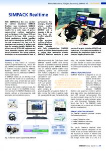
Fig. 8. System architecture supporting the ACN service. See text for description of data flow processes.
cise, it appears that the presence of Caribbean fruit fly might be predicted up to about 30 miles between observed traps. Predicting the actual number of Caribbean fruit flies when they are present appears to be more difficult, however. The semivariogram structure for fly counts in space is much less well defined than that shown in Fig. 7. In this instance, it seems that the abundance of Caribbean fruit flies may only be predictable up to 4 miles from any other observed trap data. Nevertheless, the above analysis suggests there may be promising applications for mapping the presence of Caribbean fruit fly and their occurrence through time.
components, while circles represent user and usability components. The arrows represent the direction of information flow. The center of the image contains the Data Repository, since that represents a central exchange point through which all information flows. This is a repository structured so that spatial and temporal information regarding pest species and abundance can be easily archived and accessed. We adopted the SABI-Scout universal algorithm to accommodate collection of population census data for any geographical crop-pest domain. This universal architecture means that surveillance tasks for any critical citrus insect or disease can be accomplished using the same visual interface. By employing the principles of universal design, we can address essential aspects of both the regulatory paper-based system and the information needs of a real-time science-based analysis of Caribbean fruit fly or any other citrus insect or disease. Data from three primary sources can flow into the Data Repository: 1) field data; 2) harvested data; and 3) marketing information. Field data enters the system from one of several sources, including PDA observations, precision agriculture inputs or grower-centric information such as yields, if available. Harvested data represent data those that reside on the web or other digitally accessible location and which are automatically harvested into the system through the M Language. Market-based information represents that information supporting the marketing and sales of crops. Examples include Certification Reports and other reports required to maintain open access to domestic and international markets. The simplest user aspect of the system is the ability to generate summary reports for making field, treatment, or market decisions. Summary reports may be simple statistical reports, spatial maps, tables, charts, and graphs that describe areas of concern or some other aspect of fruit fly development. This information is then used to take some type of action that either controls the presence of the pest or that is used for marketing or tracing a crop that has been certified in an official program. Forms workflow analysis. The Caribbean fruit fly regulatory staff presented a collection of forms to the ACN development team. Included were a series of about eight forms used to identify data collection points, monitor trap counts, and issue
Track 2: Technology Development Five technological criteria guided ACN development: 1) digital accuracy and precision; 2) interoperability; 3) immediacy; 4) commercial sustainability; and 5) cost. Digital accuracy and precision (1) is important in reducing manual labor associated with duplication of effort and filing paper forms. This improves the reliability of information initially going into the system and reduces the need for human intervention in manual validation efforts. An interoperable system architecture, (2) is needed so ACN can interface with other global data sources and harvest, align, and process external information along with pest survey information (e.g., NOAA weather with citrus canker). Real-time data access, or immediacy, (3) is required since time-sensitive market, weather, and other factors can affect crop quality and the ability to ship citrus to domestic and foreign markets. The ACN service must also be commercially sustainable, (4) so it was constructed using a preexisting commercial pest surveillance architecture with a proven track record. Commercial sustainability ensures that ample resources can be directed toward the continued improvement of state-of-the-art system features. Finally, equipment costs have to be reasonable, (5) so that hardware can be affordably provided to a large number of inspectors. Component 1: Web Portal Overall ACN system architecture. A simplified architectural diagram describing ACN’s universal system structure is presented in Fig. 8. The square boxes represent data or input Proc. Fla. State Hort. Soc. 119: 2006.
115
Certification Reports. The purpose of the Certification Report is to document the status of fly detections, which are then used to issue certifications to the appropriate operations. Currently, these forms are administrated using a manual paper-based system of lookups and filing, along with hand writing or typing of the information on each form. Communications related to the forms are via faxes, phone calls, and manual e-mails. We parsed these forms to create a schema representing all data entered at every step in the information management process. There emerged a pattern in which much of the information entered on the forms was duplicated on the other forms. We eventually derived a data structure that collects and validates six to eight primary keys, and from these, any other information component needed in the certification program could be derived. This data structure was entirely consistent with our universal model for pest data organization. Our workflow analysis indicated that an approximately 50% gain in document efficiency could be obtained if this paper-based system could be digitized and automated notification systems were adopted. Component 2: Handheld PDA. The personal observations of farmers and scouts in their fields represent the greatest untapped resource of information about agricultural developments. Historically, however, this information is not well documented. We believe this is primarily due to the lack of tools and technology to facilitate the collection and archiving of observational information. Using the results of our Forms Workflow Analysis, we adapted the SABI-Scout handheld PDA system to collect and archive information from any citrus pest inspection protocol. Simulation testing against a multitude of citrus insects and diseases (Table 1) indicated that this approach should be useful for any citrus-pest domain. The only difference between the current paper-based system and the designed digital system is that the new one works via handheld computer and web server synchronization. This new system does not require that software be installed on the desktop. Instead, a user-specific profile is customized on the Web Portal (Fig. 9) based on the user’s specific census requirements, and this profile is automatically downloaded and installed on the user’s PDA device during a synchronization event (Fig. 10). Synchronization can be performed wirelessly, which is useful if there are a large number of field inspectors working out of the same office. Multipurpose spatial translator. The CFFP is based on a unit of measurement called, “Designated Area.” Designated Areas are arbitrary notations given to citrus groves participating in the CFFP. These notations are used for traceability purposes between fruit fly counts, citrus groves and their associated certifications. Generally, one Designated Area unit corresponds to one-half of a Section-Township-Range. Designated Areas may be split vertically or horizontally across their host Section-Township-Range. In contrast, citrus canker inspection programs use a different notation that involves Multi-Blocks. In other words, different inspection programs use different methods of recording spatial position for traceability purposes. Ideally, all pest inspection programs should use the same method of spatial notation, but this may not be appropriate for historical reasons. Therefore, we created a Multipurpose spatial translator, which is essentially a lookup table containing the latitude and longitude coordinates aligned with its corresponding Designated Area or Multi-Block notation. This enables the reporting of pest survey information from any 116
certification program (e.g., CFFP) to be automatically aligned with that of any other program (e.g., canker). Section-Township-Range and zip code lookups are also provided. This algorithm can be amplified to accommodate other methods of spatial notation, such as those that might be used in statistical sampling programs for citrus canker and greening diseases. Although there may be political or economic reasons why a single spatial notation model is not currently applied to pest traceability in Florida, consistency in spatial definition will be required in the future so that information from different pest domains can be overlaid and aligned with data from other subsystems, such as market, weather, horticultural or edaphic information. Automated certification reports. Industry updates and communications regarding the CFFP are administrated using a “Certification and Trapping Report.” This report describes the areas in which Caribbean fruit fly was trapped, which finds were suspect and which finds were confirmed through laboratory verification. This certification report is collated manually using a series of MS Word and Excel files and involves a dedicated, yet considerable effort each week to assemble and distribute. One of the features of the ACN system is the ability to generate automated certification reports. Since data are uploaded directly to the servers through handheld PDA data collection efforts, essential reports can be designed and automatically triggered when certain criteria are met. These automated reports can then be distributed via email, web link, or automated fax to those persons requiring critical certification, market, and shipping information. Data export capabilities. One of the most valuable features of ACN to researchers is the ability to select and directly download raw data into CSV or Microsoft Excel data formats for analysis on researcher’s local computers. This type of service is not common among similar systems, and it is one feature of the technology that makes ACN unique. The interface is easy to use and report data ranges may be selected either visually or by inputting parameters into the ACN search and extract query protocols. ACN supports heuristic and mathematical modeling to assist in decision support. Researcher-specific data export capabilities ensure scientists can download and locally run their models in real-time in the event critical pest pressure issues must be rapidly resolved. Warning buffer calculation. One important task in the Caribbean fruit fly regulatory program is the establishment of warning buffers when positive fly finds are encountered. Currently, these determinations are labor-intensive and involve correlating data on paper with manually looked-up aerials. From there, a protractor is used to draw a circle around a general location of a positive fly trap. These are time-consuming to draw and subject to inaccuracies. To provide a useful technology to the regulatory team, we customized an “on-the-fly” point-and-click feature to calculate and draw warning arcs that can be printed out and distributed using an easy-to-use on-line interface. The feature provides an automated search feature that allows users to navigate to and display a desired Section-Township-Range. The user then selects the desired buffer distance and left-clicks on an area of the map to set the center of the arc. The map then plots, updates, and displays the warning buffer on-screen, allowing the user to print and distribute the image as needed for management, quarantine or eradication purposes. A variation of this technology is being developed for growers to use in “Precision Tree Replant Proc. Fla. State Hort. Soc. 119: 2006.
Fig. 9. Example of the ACN Web Portal. Participants register and configure their personal profiles on the web. The profiles are later downloaded to their handheld PDAs when they synchronize their PDAs to the system. See text for more detailed descriptions of how this process works.
Programs” to assist in the field management of citrus greening disease. M language support. Other advanced features of ACN include the interaction of M with the ACN Data Repository. The M Language is like a translator of information between data structures. For example, ACN users may collect their information on handheld PDA devices that are then synchronized into the Data Repository. The M Language will be able query those data, then go out and search the web for other information germane to its queried ACN information. One obvious example is NOAA weather information, such as temperature, wind, etc., and this work is currently in progress at MIT. Other types of data alignment could involve pricing or market data to identify the most profitable growing regions located in the CFFP zone. M will collect, or “harvest” data from various networks and align it with ACN information that is coordinated in time and space. The resulting amplified data set may be forwarded to an M modeling component or can be sent back to the ACN Data Repository where it is archived until it is needed by the users. The harvesting of information in this fashion is limited not by the technology but only by the availability of data on the Internet. One advanced application Proc. Fla. State Hort. Soc. 119: 2006.
might be along the lines of geostatistical analysis using neural networks (Misaghi et al., 2004). Commercial Implementation Process Commercial application of ACN technology is rapid and completely customizable. It is suitable for a number of applications in the Florida citrus industry that relate to pest risk assessment (Table 3). The application model is similar to that of any enterprise-level data management platform, such as Oracle or Microsoft SQL. Once users acquire access to the SABI-Scout development platform, they follow a three-step process to configure the system for their purposes using their own rules of business intelligence: Step 1. Customization (design maps, reports, and data export subroutines and create user profiles), Step 2. Create definitions for temporal, spatial, observation, and measurement units; and, Step 3. Technology transfer and training. 117
Fig. 10. Example of the ACN PDA handheld interface. Personal profiles configured by the participants on the Web Portal are presented on their PDA devices and used in the field to guide their data collection efforts.
Step 1. Customization. The first step to imposing ACN into an organization’s workflow is to establish what are the client’s specific mapping, reporting, and data expert needs. For example, regulatory officials certifying a crop for export shipment are going to have different reporting needs than a grower tracking pests for management decisions or a reTable 3. Representative application scenarios in which ACN technology could be applied. Possibilities extend beyond this simple listing. Caribbean fruit fly certification Mediterranean fruit fly surveillance Citrus canker surveys and certification Citrus greening surveys and certification Team-based research projects Irrigation scheduling Traceability processes Decontamination compliance Storm damage assessments Real-time crop estimates Freeze damage assessments Harvest optimization Statistical data collection for research Budwood certification
118
searcher collecting statistical information for an experiment he is conducting. Microsoft’s Reporting Services architecture permits a wide variety of reports to be developed from the same underlying data structure. Thus, even though regulatory officials and growers are acquiring information into the same ACN server, their specific reporting needs can easily be configured and enabled for their own custom applications. The researcher might want a simple Excel export functionality to provide data in a particular format for this desktop statistical software, while the regulatory officials might want to produce a PDF version of a Certification and Traceability Report with automated notification services for growers and exporters. All of these client needs are met by querying data from the same underlying data structure. Step 2. Create definitions for temporal, spatial, observation, and measurement units. Once the specific reporting needs are identified, the next step to is to establish definitions for temporal and spatial coordinates, and to define client-specific observation and measurement units. Depending on client needs, the primary time measurement might be date. Some notation about Farm, Field, and Block, or Section-Township and Range, could serve as the spatial indicator. If, on the other hand, researchers were using the system for a pesticide efficacy trial, the spatial indicators could just as well be Replication, Treatment, and Block. The main observational unit in most cases might be “host plant” and the measured variable is probably some interesting insect, disease, disorder, or unknown symptom. Finally, the particular rating system is configured, and this can be any type of alphanumeric or numeric system with any number of divisions and codes, all completely customizable by the user. The specific time/space/observation/measurement configuration established by a particular user is called a “profile.” The final configuration is completely customizable based on the user’s intended application. Using the SABI-Scout Web Portal, user profiles can be created or changed at any time. New observation and measurement units can be quickly added by the users in the field. This means that an entire pest surveillance platform system can be reconfigured in matter of minutes if a new exotic disease (e.g., citrus variegated chlorosis (CVC)) is identified in the state, and sampling programs must be rapidly ramped up for a new insect-disease sampling program. Since a Multi-Purpose Spatial Translator is used to associate spatial coordinate between different pest sampling protocols used by FDACS, the specific method of pest visualization (e.g., county, Section-Township-Range, Designated Area, etc.) can be decided at a later date. Due to the universality of the underlying data structure, all of these factors reside in the same architecture, so relationships within and between different species and their environments can easily be investigated by researchers. Step 3. Technology transfer and training. Once client definitions are established, user training is conducted. Preliminary tests have shown that user training is rapid and intuitive. We estimate that a new user can be trained on how to use ACN for field pest surveillance in less than 30 min. Conclusion
The problem solved and need addressed by this project is how to consolidate survey and modeling information from a broad spectrum of important citrus pests and diseases into the same architecture by using the principles of universal design. Prior to ACN, there was no feasible means to accomplish Proc. Fla. State Hort. Soc. 119: 2006.
universal data aggregation for all important citrus insects and diseases into an interactive format simultaneously usable to five industry stakeholder groups: growers, researchers, regulators, marketers, and consumers. Based on a preexisting architecture, ACN was amplified using business intelligence rules from a Caribbean fruit fly-only system to one that can serve all important citrus insect and disease surveillance needs. ACN architecture is designed to be compatible with and support bilateral communication of information from other agricultural pest data acquisition platforms. It is also important to note that ACN data capture is not limited to insects and diseases. The ACN provides capture functions for any other abiotic, beneficial, or edaphic measurement agricultural producers believe might be important, such as yield monitoring, etc. Thus, we believe ACN is the most broadly tested citrus survey data acquisition platform to date (Table 1). ACN can also be retrofitted to preexisting databases to tap into the value of unused or combined information sources. The technological system driving ACN is formulated as a global agricultural pest surveillance model that can be adapted to other states or national certification programs with reasonable configuration changes. The Davis Productivity Awards Program (2003) recognized the cost benefits of using handheld computer technologies for collecting citrus pest information. It is ironic that we speak of integrated pest management, and yet our surveys are not. This paper represents a call to action to move from primarily paper-based methods of pest traceability to consolidated digital methods that provide greater immediacy and accessibility of temporal and spatial pest data. We believe the citrus industry and its pest risk management efforts can substantially benefit by reexamining the use of these technologies, engaging qualified and experienced expertise for both scientific and commercial development and rapidly deploying digital systems to support global certification and marketing programs (Florida Department of Citrus, 2006; Hobbs and Kerr, 2006). Acknowledgments
We would like to acknowledge the assistance of Doug Bournique and Karen Smith at the Indian River Citrus League in coordinating project meetings and venues. Calie Jenkins, Laird Weaver, Carol McKenzie, and Denise Marshall and the rest of the CFFP staff provided excellent assistance in helping us understand their certification procedures. The 2005-2006 Horticulture and Agritechnology classes at George Jenkins High School, Jim Sweeney instructor, provided valuable assistance in collecting field data near Lakeland, Florida. The efforts of Ed Burns, Ken Hibbard, and Don Harris at the Division of Plant Industry in Gainesville, Florida, in helping us acquire the City Line Caribbean fruit fly data are gratefully appreciated. Doug Bournique at the Indian River Citrus League assisted in assembling information for the section on Certification Program Economics. Literature Cited Bouffard, K. 2006. Quarantine hits citrus shipments. The Lakeland Ledger, June 7, 2006. Brock, D., E. Schuster, and T. Kutz, Sr. 2006a. An overview of the M Language. MIT-DATACENTER-WH-OO9. MIT Data Center, Cambridge, MA, http://www.mitdatacenter.org/MIT-DATACENTER-WH-009.pdf Brock, D., E. Schuster, and C. Thumrattranapruk. 2006b. Multi-lingual display of business documents. MIT Data Center, Cambridge, MA, http:// www.mitdatacenter.org/MIT-DATACENTER-WH-010.pdf
Proc. Fla. State Hort. Soc. 119: 2006.
Browning, H. W., R. McGovern, L. Jackson, D. Calvert and W. Wardowski. 1995. Florida Citrus Diagnostic Guide. Florida Science Source, Lake Alfred, FL. Burditt, A. 1982. Anastrepha suspensa (Loew) (Diptera: Tephritidae), McPhail traps for survey and detection. Fla. Entomol. 65:367-373. Capoor, S. P., D. B. Rao, and S. M. Viswanath. 1967. Diaphorina citri, a vector of the greening disease of citrus in India. Indian J. Agr. Sci. 37:572-576. Clark, I. and W. V. Harper. 2000. Practical Geostatistics 2000. Ecosse North America, Columbus, OH. ISBN: 0-9703317-0-3, 442 p. Cressie, N. 1991. Statistics for spatial data. John Wiley & Sons, New York. Cunningham, R. 1989. Population detection, pp. 169-173. In: A. S. Robinson and G. Hooper (eds.). World Crop Pests 3B. Fruit Flies: their biology, natural enemies and control. Elsevier, Amsterdam. Davis Productivity Awards Foundation. 2003. Davis Productivity Awards Program, December 8, 2002. Florida TaxWatch, Tallahassee. p. xxvii. De Woskin, R. 1981. Medfly training manual. Joint cooperative Mediterranean fruit fly eradication project. USDA, Calif. Dept. Food and Agr., Santa Clara County Agr. Commissioner, Alameda County Dept. Agr., 215 p. EPPO/CABI. 2006. Data sheets for quarantine pests: Citrus greening bacterium. http://spdn.ifas.ufl.edu/EPPO_data_sheet.pdf. Fielding, R. 2000. Architectural styles and the design of network-based software architectures. PhD Thesis, Univ. of Calif., Irvine. Florida Department of Agriculture and Consumer Services. 2006a. Highlights of citrus grower responsibilities for the 2005-2006 harvesting season. Division of Plant Industry, Bureau of Pest Eradication and Control, Citrus Canker Eradication Program, Lake Alfred, FL, 1 p. Florida Department of Agriculture and Consumer Services. 2006b. Notice of proposed rule development: Citrus Nursery Stock Certification Program. DPI, Draft, May 16, 2006. Gainesville, FL. Florida Department of Citrus. 2006. Florida Citrus and Economic Indicators. http://www.floridajuice.com/user_upload/files/ei-0106_43d53329e10ce.pdf. Graham, J. H. 2001. Varietal susceptibility to citrus canker: Observations from southern Brazil. Citrus Ind. 82:15-17. Hendrichs, J. 1996. Action programs against fruit flies of economic importance: Session overview, pp. 513-520. In: B. A. McPheron and G. J. Steck (eds.). Fruit fly pests, a world assessment of their biology and management. St. Lucie Press, Delray Beach, FL. Hobbs, J. and W. Kerr. 2006. Consumer information, labeling and international trade in agri-food products. Food Policy 31(1):78-79. Horn, D. 1988. Ecological approach to pest management. Guilford Press, New York. McPhail, M. 1939. Protein lures for fruit flies. J. Econ. Entomol. 32:758-761. Misaghi, F., S. Dayyanidardashti, K. Mohammadi, and M. R. Ehsani. 2004. Application of artificial neural network and geostatistical methods in analyzing strawberry yield data. ASAE Paper No. 041147. ASAE, St. Joseph, MI. Murray, J. 2001. Mathematical biology: I: An introduction. 3rd ed. Springer Science+Business Media, Inc., New York. Nigg, H. N., S. E. Simpson, and J. L. Knapp. 2004. The Caribbean fruit fly flyfree zone program in Florida, USA, pp. 179-182. In: B. N. Barnes (ed.). Proc. 6th Intl. Fruitfly Symp. on Fruit Flies of Economic Importance, Stellenbosch, South Africa, May 6-10, 2002. Rhode R. H., J. Simon, A. Perdomo, J. Gutierrez, C. F. Dowling, Jr., and D. A. Linquist. 1971. Application of the sterile-insect-release technique in Mediterranean fruit fly suppression. J. Econ. Entomol. 64:708-713. Riherd, C. 1993. Citrus production areas maintained free of Caribbean fruit fly for export certification, pp. 407-413. In: Proc. Intl. Fruit Fly Symp. Antiqua, Guatemala, October 1990. Rogers, J. 1992. Estimating citrus rust mite population densities with the HB system. Citrus Ind. 73(1):60-62. Rogers, J., C. McCoy, and M. Manners. 1993. Standardized comparison keys improve accuracy in rapid estimations of citrus rust mite populations. Citrus Ind. 74(10):30-35. Rogers, S. 1995. Farmers on the Internet: A vital resource for sustaining our future food supply. Citrus Ind. 76(9):36-40. Rogers, S. 1996. The plant pathologist in private practice. Plant Dis. 80(1):5-13. Rogers, S. 1998. Medflies, malathion and public speaking. Citrus Ind. 79(1):21. Rogers, S. 2000. Citrus canker: Science policy and new technologies for management. Citrus Ind. 81(7):10-12,51-54. Thomas, D., T. Holler, R. Heath, E. Salinas, and A. Moses. 2001. Trap-lure combinations for surveillance of Anastrepha fruit flies (Diptera: Tephritidae). Fla. Entomol. 84(3):344-351. Thornsbury, S. 1998. Technical regulations as barriers to agricultural trade. PhD Dissertation to Virginia Polytechnic Institute and State University. Blacksburg, Va., 192 pp. Zerva, A. 2004. Effects of afforestation and forest management on soil carbon dynamics and trace gas emissions in An Sitka Spruce (Picea sitchensis (Bong (Carr.)) Forest. PhD Thesis, Univ. of Edinburgh, Institute of Atmospheric and Environmental Sciences, Edinburgh, Scotland.
119