Evaluation of GIS-Based Design Tool to Support Decision Making within Collaborative Spatial Planning Wies Vullings, Arend Ligtenberg, Jandirk Bulens Centre for Geo-Information, Wageningen-UR Wageningen, The Netherlands
[email protected],
[email protected],
[email protected]
SUMMARY Spatial planning processes are becoming more complex and stakeholders are becoming more interested in taking part in spatial planning processes that affect the environment they live in. This trend of increasing participation rate within the spatial planning process demands a different approach. In 2003 a new instrument that facilitates increased collaboration of stakeholders was developed by Centre for GeoInformation and Wageningen Software Labs of Wageningen–UR. This GIS-based instrument operates in a group decision room setting and has a limited set of functionalities. The new instrument, has been tested in two case-studies: a strategic and an operational workshop. After the workshops participants were asked to give their opinion about its working. In general it was said to accelerate the planning process considerably and it was said to have the same advantages as other group decision software. Points of improvement were sometimes of technical nature others involved the preparation of a session. In Conclusion can be said that MapTalk can be a valuable instrument to support decision making within collaborative spatial planning processes, but that positioning of the instrument within the process needs further research.
KEYWORDS: collaborative spatial planning, GIS, decision support, group decision room INTRODUCTION Spatial planning problems are becoming increasingly more complex. They require the competency of experts from different fields, involve stakeholders with diverging interests, and may affect a large number of people (Voss et al, 2003). In general stakeholders are becoming more assertive and are not longer satisfied by only being informed. They like to actively participate in processes like spatial planning processes that affect them and the environment they live in. This trend of increasing participation rate in the spatial planning from informing and consulting towards co-producing and co-deciding, demands a different approach. At Wageningen-UR work has been done by Centre for Geo-Information and Wageningen Software Labs (W!SL)58 on the development of an application that facilitates increased collaboration of stakeholders. This application has been developed in the past two years from an idea into a multi-functional software application. Although the application seemed to fulfil the requirements that were set at the start of the development crucial questions such as in what type of planning process can it be used, in which phase of a planning process, are non-experts able to perceive the functionalities, etc. still needed to be answered. In order to find answers for those questions concerning the usability of the application within the participatory spatial planning process the application was tested in two case studies. The objective of this paper is to review the possibilities of the instrument MapTalk in terms of points of improvements and added value within collaborative spatial planning processes. 58
Contact person: Jan-Erik Wien, Wageningen Software Labs,
[email protected]
“7th AGILE Conference on Geographic Information Science” 29 April-1May 2004, Heraklion, Greece Parallel Session 8.2- “Decision Support Systems” 717
This paper starts with a description of the characteristics of a collaborative spatial planning process. Next it describes how current techniques like found in group decision rooms enhance the meeting and decisionmaking process and also identifies it shortcomings to facilitate spatial planning processes. The third section describes the MapTalk application in terms of functionalities and organisatorial aspects of a MapTalk session. The fourth section describes the spatial planning cases carried out with MapTalk and discusses the outcome of those sessions. Finally we end with some concluding remarks.
COLLABORATIVE SPATIAL PLANNING PROCESS Spatial planning processes are becoming more collaborative. The participatory rate of spatial planning processes is developing from an informative or consultancy process into a co-production or even a codecision process. In co-production and co-deciding processes actors actively participate in the planning process. This will result in support of the actors for the developed plans, since they have been an active partner in the production of the plans or the decisions about the plans (Twist et al, 1998). A Collaborative spatial planning process has often an iterative character and can be defined by a general set of phases (Friend and Hickling, 1987): • Orientation: getting to know the participants, the area and the problems and selecting relevant themes for the session • Problem scanning: Aim of this phase is to get a complete picture of the problems in the area with help of many different stakeholders. • Shaping: During this phase the problems are defined and in a structured way an analyses of direction in which solutions can be found is made. This phase results in a legend to be used during the designing phase. • Designing :The aim of this phase is to create new designs. • Comparing: This phase aims to compare the different designs with each other and to define arguments in favour to or against designs • Choosing : A selection is made amongst the designs for the most potential design(s) • Doing : Finally a plan is made to implement the selected design(s). • Evaluating
Within spatial planning processes a distinction can be made between a strategic and operational level. Strategic planning evolves on a more abstract level and generally results in a vision for a certain region. Strategic planning is generally done at national or regional level. Operational planning concerns in general projects on regional and local level and results in concrete plans for a certain region or location. The increasing participartory rate of spatial planning processes also sets new requirements for instruments that can be or are used. At least three characteristics of the participatory planning process influence the suitability of its supporting instruments: the diversity of participants involved; the increased interaction between participants and between participants and the supporting systems; and the characteristics of the planning method, planning process and policy content (Geertman and Stillwell, 2003). An important issue that is clearly linked with the diversity of participants involved (the rate of affinity with IT/GIS) and the participant and userinterface is GIS en IT understandability, which is addressed by Kingston et al. (2003). They state that the lack of familiarity with the technology could be an obstacle to participation. They advise to overcome this problem by structuring information, following standard usability guidelines, testing with a broad range of users and not overload users. Transparency is also seen as an important prerequisite for support instruments and the way they are handled (Geertman and Stillwell, 2003).
GROUP DESICION ROOM A Group decision room is an electronic meeting system consisting of a network of a number of computers. A group decision room has a number of specific characteristics. A GDR session is anonymous, which lowers the threshold to give one’s own opinion. All participants have an equal chance
718
in giving their opinion, matters of hierarchy or ‘the loudest voice’ have no influence in this system. During a GDR session participants can react simultaneously to a question or proposition, which results in more input in less time and creates possibilities for a broader and more active participation of the participants. A third characteristic is that the system has a group memory, which means that all information and all opinions are digitally reported, resulting in a considerable time profit while making the final report. A fourth characteristic is that a GDR session offers a framework and a process structure for meetings. (Miller et al, 1999 ; Jankowski en Kloppenburg, 1997).
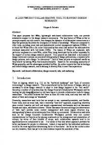
MAPTALK Group decision rooms have proven their advantages within group processes. However the spatial component of spatial planning processes is very hard to perceive by existing groupware, which are basically text oriented. MapTalk is a newly developed instrument that combines the advantages of a group decision room setting with GIS functionality (figure 1). Maptalk enables participants to visualize their own ideas in a spatial design by drawing it on the screen. The basic concept of MapTalk entails that participants work alternately individual and plenary. During the individual part the participants can draw their individual ideas on to a map and add an explanation. During the plenary part the MapTalk server collects, combines and presents all ideas on a big screen by a beamer. Conflicts and consensus areas become clear straight away. Participants can explain their ideas referring to their design and the chairman has the facilities to edit the individual design to a design on which all participants agree.
Figure 1: Maptalk in GDR setting
719
Functionalities
Maptalk has a preparation and session mode. The preparation mode in which a session can be prepared entails the definition of legend units and the entering of map layers. The preparation of a session can be done on forehand by the facilitator or it can be implemented as part of the participatory process. The session mode offers a range of basic drawing tools in a simple GIS environment. Objects can be drawn as a point, line or polygon feature, and can be edited, moved and erased. Objects can be labelled and text can be added to a label (e.g. clarification of object). Besides a basic background map, MapTalks offers the opportunity to include a library of maps, so different maps can be displayed and used as input or background for a design. The different maps can be easily added during the preparation mode, by importing them from standard GIS packages. A voting tool within the application offers the possibility to let participants vote for a specific design. MapTalk offers functionality to carry out spatial overlays on an object level. The advantage of using MapTalk in a planning session over a GIS system is that MapTalk has a limited set of functionalities. The functionalities are selected upon their use within the planning process. Obviously not all functionalities are needed in every process depending on the kind of process (e.g. voting is not always necessary) or the level of GIS-knowledge of the participants (modifying objects might be to advanced). For this reason the interface can be customised by the facilitator in the preparation phase to select the needed functionalities for a certain session. MapTalk can be easily installed. At Wageningen-UR MapTalk is installed on a mobile Group Decision Room which consists of 10 laptops and additional tools such as printers, a smartboard and a beamer. It is possible to use MapTalk within a bigger group than 10 persons by sharing the laptops or have other participants vote for the best design. On the Group Decision Room laptops other text-oriented groupware is installed, which makes switching between MapTalk and other software possible (Ligtenberg et al., 2004). Organisation of MapTalk session
A session consists of an individual part in which individual participants create their design using the drawing tools described above. In the plenary part the participants send their designs to the facilitator, who is operating the server. The facilitator is able to display the designs in different ways. The designs can be displayed per design or per legend item. In this phase the screens of the computers turns blank, except for the server, which is projected onto a big screen. This effectuates that everybody focuses on the big screen and thus facilitating the discussion. The chairman can assign the control over the mouse to a participant, so each participant can clarify their own design and point out issues with use of the mouse. Only the facilitator can edit the designs during this phase. At the end of this phase the chairman can send back the original designs or the edited version. At this point an individual phase starts again.
CASE STUDY 1: NEDERWEERT Setting In 2002 Limburg, a province in the South of the Netherlands, was involved in a spatial planning process that aimed at the reconstruction of the intensive agriculture sector, alongside with more general regional aims of economic vitality, nature conservation and spatial quality. During this process workshops were organised to share knowledge, make knowledge generally accepted, and create new knowledge. People from different backgrounds (policymakers, farmers) worked on designs for future development of areas within their province. During this process they were supported by process facilitators and landscape designers. In 2003 one of the workshops was selected to be replayed with slightly different objectives, a few new participants and with the support of MapTalk. Although the reconstruction process was in a more concluding phase at the moment people were willing to replay the workshop and try out MapTalk (Steekelenburg, 2003).
720
Programme During this workshop not a complete set of general phases of the collaborative spatial planning process were followed, but a selected set of the orientation phase, the design phase and the comparing phase. The workshop consisted of four parts. First a brief introduction was given about the objectives of the session and a short explanation of Maptalk was given. After that an orientation session was done to get acquainted with the area and the participants. In the second session participants were asked to develop an overall story for the area by means of creating three objects. One of the objects had to be a nature reserve, the second an area meant for intensive agriculture and the third object could be chosen freely. During the discussion the objective of the third and last session of the workshop was defined. In this session the group was divided in three groups and each group worked on their vision and ideas for the agricultural sector. At the end of this session every group presented their design. Objectives The main objective was to improve spatial quality in Nederweert and create space for agriculture and nature. The second objective was to try out MapTalk in a strategic participatory spatial planning process on a regional level. Evaluation At the end of the workshop the participants were asked to give their opinion about MapTalk. Participants were asked to describe their opinion in terms of ideas for improvement, added value and applicability. The general impression was that MapTalk had accelerated the planning process considerably. The discussion was a lot easier since everybody knew exactly which area was spoken about. As a point of improvement the readability of the maps was mentioned: when all nine participants had created three or four new objects and had written some text in the labels the overall picture became unreadable. Another point of concern was the novelty of the techniques of drawing with the computer and GIS functionalities. Not all participants felt comfortable with the techniques and needed some time to get use to it. A suggestion was done to send participants on forehand a trial version of MapTalk so they can do some exercises at home.
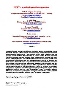
CASE STUDY 2: FRIESLAND Setting The second case study MapTalk was used in the second brainstorm session of an allocation study that dealt with creating extra surface water retention capacity in Friesland, one of the northern provinces of the Netherlands. The province of Friesland had assigned the ministry of Agriculture to carry out this study. The study aimed at finding locations that had the best chance to be developed into surface water. During the brainstorm session that was supported by MapTalk the participants were asked to investigate with use of other maps (provincial plans, elevation map, topology) the feasibility of ideas that were generated in a previous session. Programme The programme of this workshop did not follow the complete set of general phases of the collaborative spatial planning process since this workshop was the second workshop in this project. During this workshop the comparing and voting phase were carried out. The workshop consisted of four parts. First a brief introduction was given about the objectives of the session and a short explanation about Maptalk was given. After that an orientation session was done to similar to the one of the first case study. The participants of this workshop were not the same as during the first workshop, since this workshop focussed on estimating the social, political and economical support. For that reason people with a more political background were invited to participate. After the orientation session four parts followed in which different sets of ideas were presented to the participants to be investigated. In every part participants were asked to vote for the idea with the highest potential. After voting the participants were asked to explain their choices (figure 2). At the end of the afternoon a map was created with a top 4 most potential sites for creating extra water retention capacity in Friesland.
721
Figure 2: result map Objectives The main objective of this meeting was to select potential areas for an extension of water retention capacity in Friesland. A second objective was to try out MapTalk in an operational participatory spatial planning process on a regional level. Evaluation At the end of the session an evaluation with similar questions as during the previous case study was held. Many the same remarks were made, but also some new items were brought up. On the issue of added value of use of MapTalk was said that every reaction was equal and communication happened in a very relaxed way. Everybody stayed involved and the process was very transparent. On the issue of points of improvements was said that it is important to make a good choice concerning the maps that are needed during preparation. Furthermore the technical and process facilitators need to work together more closely in order to give a smooth performance.
CONCLUDING REMARKS MapTalk as an instrument
The evaluations of the two case studies provided insight in opinions of participants about MapTalk. The characteristics of a GDR session were mentioned as being important advantages for MapTalk as well. Having an equal chance in giving a reaction with no influence of hierarchy and intimidation were often mentioned as great advantages. A highly appreciated aspect of working with MapTalk was the instantaneously reporting of the results. After a MapTalk session the all participants received a report
722
containing the maps created during the various stages of the meeting including a summary of the discussions. An important reaction was that although MapTalk has a limited number of functionalities some participants needed more time than was given to get used to the application. Extra time to practise on forehand was regarded as needed. Another major point for improvement was the issue of preparation. An intensive preparation is regarded as essential to enable a smooth running programme. Decisions have to be made on which maps are necessary, since too many maps make the system slower and make participants lose track. A number of reactions concerned technical matters like the readability of the maps, when too many labels are displayed. These reactions of technical nature will be taking care of during further development of the instrument. Furthermore, using MapTalk demands a technical facilitator who knows exactly how to operate MapTalk and how to use its functionalities to the advantage of the process. Cooperation between the process facilitator and technical facilitator is essential. MapTalk as support for decision collaborative spatial planning process MapTalk facilitates participatory spatial planning by making problem and consensus areas visually explicit and by creating a spatially oriented discussion. The general opinion of the participants was that MapTalk accelerates the discussion and that it enables a better focus to discuss through the visual support of maps. Both case studies focussed on regional scale, for that matter no conclusions on the use of MapTalk in different scale levels can be made. The two cases differ in their levels of abstractness, the first one was a strategic planning process, the second an operational planning process. In both cases the use of MapTalk showed clearly an added value, although a certain degree of concreteness is necessary to benefit maximally of the use of MapTalk. With that we mean that the process should be in the stage that the question focus on issues like’ where are we going to do what?’ If the first case study had been the first workshop of the strategic planning process, it would probably not have been concrete enough for MapTalk to be used successfully.
With the two case studies not all general phases of the collaborative spatial planning process have been dealt with. Further research is necessary to look at the usability of MapTalk in the other phases of the process. As a final conclusion it can be said that MapTalk is a valuable instrument to support decision making within collaborative spatial planning processes, but that positioning of the instrument within the process needs further research.
BIBLIOGRAPHY Friend, J., Hickling, A. 1987 Planning under pressure: strategic choice approach. Oxford Pergamon press. Geertman, S., Stillwell, J., 2003. Interactive Support Systems for Participatory Planning. In Planning Support Systems in Practice: Advances in Spatial Science. S. Geertman, J. Stillwell (eds). P. 2544. Springer, Germany. Kingston, R., Evans A., Carver, S., 2003. Public Particiaptory via On-Line Democracy. In Planning Support Systems in Practice: Advances in Spatial Science. S. Geertman, J. Stillwell (eds). P. 4564. Springer, Germany. Jankowski, N.W., Kloppenburg, A.J. 1997 Verkenning GDSS. http://www.xsaall.nl/~roesderz/zakelijk/beslissoftware/voorw.htm Ligtenberg, A., Vullings, L.A.E., Bulens, J.D.MapTalk: de Group Decision Room voor Ruimtelijke Planning. In Agro Informatica 17 nr.1, 4 pp Miller, P., Rosa, M., Stearns. F., Wilson, M. 1999. Group supports systems. IS 512 Project 11. http://research.refco.com/gss/index.html Steekelenburg, M. 2003.The use of digital map drawing tools in participatory spatial planning processes. In From Tacit to explicit knowledge. G. Tress, B. Tress, M. Bloemmen (eds.). Alterra, Delta Series 3, Wageningen
723
Twist, M.J.W., Ten Heuvelhof, E.F., Edelenbos, J. 1998, Ontwikkelingen in wetenschap en technologie. ICT: mogelijkheden voor sturing en ontwerp in landelijke gebieden. NRLO-rapport nr 98/12, Den Haag Voss, A. Voss, A., Gatalsky, P., Oppor, L. 2003. Prototype and further requirements of a real participatory GIS in Proceedings of the 6th Agile conference, p. 613-622. Lyon.
724