RESEARCH ARTICLE
Exploration of the spatial patterns and determinants of asthma prevalence and health services use in Ontario using a Bayesian approach Alexandra M. Oue´draogo ID1*, Eric J. Crighton1,2, Michael Sawada2, Teresa To1,3,4, Kevin Brand5, Eric Lavigne6,7
a1111111111 a1111111111 a1111111111 a1111111111 a1111111111
1 Institute for Clinical Evaluative Sciences, Toronto, Ontario, Canada, 2 Department of Geography, Environment and Geomatics, University of Ottawa, Ottawa, Ontario, Canada, 3 The Hospital for Sick Children, Toronto, Ontario, Canada, 4 Dalla Lana School of Public Health, University of Toronto, Toronto, Ontario, Canada, 5 Telfer School of Management, University of Ottawa, Ottawa, Ontario, Canada, 6 Air Health Science Division, Health Canada, Ottawa, Ontario, Canada, 7 School of Epidemiology and Public Health, University of Ottawa, Ottawa, Ontario, Canada *
[email protected]
Abstract OPEN ACCESS Citation: Oue´draogo AM, Crighton EJ, Sawada M, To T, Brand K, Lavigne E (2018) Exploration of the spatial patterns and determinants of asthma prevalence and health services use in Ontario using a Bayesian approach. PLoS ONE 13(12): e0208205. https://doi.org/10.1371/journal. pone.0208205 Editor: Tayyab Ikram Shah, Western University, CANADA Received: July 29, 2018 Accepted: November 13, 2018 Published: December 10, 2018 Copyright: © 2018 Oue´draogo et al. This is an open access article distributed under the terms of the Creative Commons Attribution License, which permits unrestricted use, distribution, and reproduction in any medium, provided the original author and source are credited. Data Availability Statement: The dataset from this study is held securely in coded form at ICES. While data sharing agreements prohibit ICES from making the dataset publicly available, access may be granted to those who meet pre-specified criteria for confidential access, available at www.ices.on. ca/DAS. The full dataset creation plan and underlying analytic code are available within the paper and its Supporting Information files.
The purpose of this study was to examine the spatial variability of asthma outcomes in Ontario, Canada and broad environmental factors that contribute to this variability. Age-/ sex-standardized asthma prevalence and health services use rates (2003–2013) were obtained from a provincial cohort of asthma patients. Employing an ecological-level study design, descriptive and Bayesian spatial regression analyses were used to examine patterns of asthma outcomes and their relationship to physical environment, socioeconomic environment and healthcare factors. Significant spatial variation in asthma outcomes was found between southern urban/suburban areas and northern/rural areas. Rurality was found to have a substantial effect on all asthma outcomes, except hospitalizations. For example, the most rural areas were associated with lower asthma prevalence and physician visits [RR = 0.708, 95% credible interval (CI): 0.636–0.795 and RR = 0.630, 95% CI: 0.504–0.758, respectively], and with higher ED visits (RR = 1.818, 95% CI: 1.194–2.858), when compared to urban areas. Strong associations were also found between material deprivation and ED visits (RR = 1.559, 95% CI: 1.358–1.737) and hospitalizations (RR = 1.259, 95% CI: 1.143– 1.374). Associations between asthma outcomes and environmental variables such as air pollution and temperature were also found. Findings can be expected to inform the development of improved public health strategies, which take into account local environmental, socioeconomic and healthcare characteristics.
PLOS ONE | https://doi.org/10.1371/journal.pone.0208205 December 10, 2018
1 / 16
Spatial patterns and determinants of asthma in Ontario
Funding: The authors received no specific funding for this work. Competing interests: The authors have declared that no competing interests exist.
Introduction Asthma is the most common chronic respiratory disease, affecting an estimated 334 million people globally [1]. Asthma places a considerable burden on affected individuals, the health care system and society as a whole in terms of lost productivity. However, the asthma burden is not spatially homogenous. In fact, in the context of Ontario, Canada, it has been shown that there is a 5-fold variation in asthma prevalence rates across the province [2]. And while risk factors such as genetic predisposition, atopy, infections, diet and second-hand smoke are commonly identified as important individual asthma risk factors [3–5], they do not adequately explain the considerable spatial heterogeneity that has been identified previously [6,7]. Looking beyond individual risk factors, this study uses an ecological level study design and Bayesian spatial analysis approach to examine the potential effect of environmental, socioeconomic and healthcare factors on asthma prevalence and health services use in the context of Ontario, Canada. There is a vast international body of research on the association between asthma development and exacerbations and individual level risk factors. Studies have shown, for example, strong relationships between asthma outcomes and genetic predisposition [4], exposure to allergens and infections [3,8] and modifiable behavioural factors such as cigarette smoking and diet [5]. Less well understood but increasingly recognized as important, is the role of socioeconomic factors in determining asthma and asthma outcomes [6,9,10]. For example, Gwynn (2004) found higher asthma prevalence among US adults with low socioeconomic status (SES), defined as low education or income, when compared to adults with higher SES. In northern Sweden, Hedlund et al. (2006) found increased risk of developing asthma and respiratory symptoms in manual workers when compared to executives and civil servants, which was mainly attributed to differences in occupational exposures and smoking habits. To better understand the spatial epidemiology of the illness, many area-level studies have used exploratory analyses based on the simple visualization of standardized mortality/morbidity rates (SMRs) [2,11,12] or non-spatial regression analyses to explore associations with potential covariates [13,14]. The analysis of SMRs is limited by the fact that estimates may be unstable due to overdispersion in disease counts. For example, extreme values may be observed in areas with low or sparse populations. This method also does not account for similarities of disease risk in neighbouring areas (i.e. spatial correlation), which may be due to shared socioeconomic characteristics or environmental exposures [15,16]. In addition, while non-spatial regression analyses can account for potential covariates, they do not account for residual spatial correlation, which can be due to unmeasured confounders or shared characteristics between neighbouring areas. For these reasons, there is an increasing interest in using Bayesian spatial methods to account for overdispersion, unmeasured confounding, and spatial correlation, and thus, to better understand the geographic patterns of health outcomes [17,18]. A number of recent studies have used these methods to describe the spatial and/or temporal trends of asthma and identify at-risk areas [19–23]. For example, Boulieri et al. (2016) found that risk of chronic respiratory diseases was highest in urban northeastern parts of England and suggested this may be due to higher deprivation, air pollution or smoking prevalence in these areas. This study builds on a previous Ontario study that examined the geographic patterns of asthma prevalence across the province [11]. While findings showed clusters of high rates in many urban and industrial areas and clusters of low rates in suburban and most rural areas, the research did not examine other health care use outcomes or the factors that determine these patterns. This research addresses this gap by examining the spatial patterns of multiple outcomes, including asthma prevalence, physician visits, emergency department (ED) visits
PLOS ONE | https://doi.org/10.1371/journal.pone.0208205 December 10, 2018
2 / 16
Spatial patterns and determinants of asthma in Ontario
and hospitalizations, and by investigating the role of ecological level environmental, socioeconomic and health care factors using a Bayesian spatial approach. Findings can be expected to inform the development of improved public health strategies, which take into account local environmental, socioeconomic and health care characteristics.
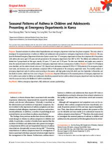
Materials and methods We conducted a population-based, ecological-level study to examine the spatial variation of asthma outcomes in the province of Ontario, Canada, and factors that may explain this variation over an 11-year period (2003 to 2013). The geographic unit of analysis used here is the secondary sub-Local Health Integration Network (sub-LHIN). Ontario is divided into 14 LHINs which are subdivided into sub-LHINs (n = 141) for more refined local planning (average population = 12,901) (Fig 1). Ontario is the most populated province in Canada with approximately 14 million residents [24]. The population’s distribution varies from sparsely populated rural areas in the North to densely populated urban areas located mostly in the South. For residents of Ontario, access to health care services is universal through the Ontario Health Insurance Program (OHIP), although northern and rural residents must frequently travel significantly longer distances to access health services as compared to urban residents [25,26].
Asthma outcomes A total of four asthma outcome variables were examined in this research: prevalence, asthmaspecific physician visits, ED visits and hospitalizations. This data was obtained through the Ontario Asthma Surveillance Information System Database (OASIS). OASIS is a validated registry of all Ontario residents with asthma (International Classification of Diseases ICD-10 codes: J45, J46), housed at the Institute for Clinical Evaluative Sciences (ICES), an independent, not-for-profit research institute. The registry was generated using: (1) Ontario Health Insurance Plan (OHIP) database, which contains information on billings for physician services; (2) Canadian Institute for Health Information Discharge Abstract Database (CIHI-DAD), which contains information on hospitalizations; (3) National Ambulatory Care Reporting System (NACRS), which contains data on emergency room visits; and (4) Registered Persons Database (RPDB), which contains personal information of individuals registered for OHIP such as age, gender, health card number, and postal code (which determines the residential location per sub-LHIN). These datasets were linked using unique encoded identifiers and analyzed at ICES. Prevalent asthma cases are defined as anyone with at least two asthmarelated physician visits within two consecutive years and/or at least one asthma hospitalization since April 1, 1991. This definition, described in detail elsewhere [27,28], yielded 89% sensitivity and 72% specificity in children (ages under 18) and 84% sensitivity and 76% specificity in adults (18 years and over). Due to the evidence that asthma may remit but not resolve, identified individuals with diagnosed asthma remain in the registry until they die or relocate outside of the province. Average prevalence and health services rates were calculated over the 11-year study period. This method was used to minimize variations due to random fluctuations of small numerators relative their denominators from year to year. Population estimates for all sub-LHINs were not available from any one source, therefore sub-LHIN prevalence rates were calculated using 2009 weighted population data from the RPDB, 2006 population data at a primary sub-LHIN level from the Ministry of Health and Long-term Care, and 2003-to-2013 intercensal and postcensal population estimates at the LHIN level from Statistics Canada. Prevalence rates were calculated by dividing the number of individuals meeting the asthma case definitions by the
PLOS ONE | https://doi.org/10.1371/journal.pone.0208205 December 10, 2018
3 / 16
Spatial patterns and determinants of asthma in Ontario
Fig 1. Study area, Ontario sub-Local Health Integration Network (sub-LHINs) (version 9). https://doi.org/10.1371/journal.pone.0208205.g001
sub-LHIN population whereas health service use rates were calculated by dividing the number of individuals who used the particular health service (asthma-specific) by the prevalent population. Using the 2009 Ontario population, rates were age and sex standardized (indirect method) and standardized morbidity ratios (SMRs) were then calculated.
Explanatory variables The choice of explanatory variables was informed by a population health framework [29] and by the determinants of asthma literature [6,7,9]. Explanatory variables included in the analysis are grouped into three categories: physical environment, socioeconomic environment, and health care access (Table 1). Environmental data was obtained from three different sources and includes pollen concentrations, air pollution concentrations and climate normals. Ontario pollen counts from mid-March to mid-October and covering a five-year period (2006–2011) were obtained from Aerobiology Research Laboratories Inc., Canada. Average total pollen concentration maps for the period 2006–2011, at a 10km resolution, were produced using an inverse distance weighting technique. This data is based on seven pollen-sampling stations across Ontario, primarily located in the southern region, which collect daily concentrations from various types of pollen including grasses, trees and weeds. Due to the limited number of
PLOS ONE | https://doi.org/10.1371/journal.pone.0208205 December 10, 2018
4 / 16
Spatial patterns and determinants of asthma in Ontario
Table 1. Description of explanatory variables. Variables
Description
Data sources
Pollen
Total pollen concentration for the period 2006–2011 (p/m3)
Aerobiology Inc.
PM2.5
Average concentration of fine particulate matter air pollution between 1998–2006 (ug/m3)
Health Canada
NO2
Average 2006 Nitrogen dioxide (NO2) concentration (ppb)
Precipitation
Mean annual precipitation over 30 years (mm)
Maximum temperature
Extreme maximum temperature over 30 years (˚C)
Relative humidity
Mean annual relative humidity over 30 years (%)
Physical environment
AdaptWest
Socioeconomic environment Material deprivation % no high school graduation, lone parent families, government transfers, unemployment, low income, homes needing major repairs (standardized scores: e.g. lowest scores = least deprived; highest scores = most deprived) Residential instability
% people living alone, youth, persons per dwelling, apartments, married, owner-occupied house, residential mobility in past 5 years (standardized scores)
Ethnic concentration
% recent immigrants and visible minorities (standardized scores)
Dependency
% seniors, ratio of population ages 0–14 and 65+ to population ages 15–64, labour force participation (standardized scores)
ON-Marga
Health care access Physicians
Number of family physicians and general practitioners per 10,000 persons
IPDBb
Rurality
Degree of rurality, ranging from 1 (urban/least rural) to 6 (most rural)
AOHCc
a
ON-Marg: Ontario Marginalization index.
b
IPDB: ICES Physician database.
c
AOHC: Association of Health Centre.
https://doi.org/10.1371/journal.pone.0208205.t001
stations, pollen concentration values are considered crude estimates. Postal code-level pollution variables were obtained from Health Canada. These included satellite-derived long-term estimates of air pollution, specifically annual concentration of fine particulate matter with diameter of 2.5 μm or less (PM2.5) for the period of 1998–2006, as well as average 2006 nitrogen dioxide land-use regression (NO2-LUR) model estimates [30,31]. The 2006 NO2-LUR variable was chosen because it was found to produce the most reliable estimates on within-city variability [31]. Finally, climate normals estimates over 30 years for mean annual precipitation, relative humidity (RH) and extreme maximum temperature at 1 km resolution, were obtained from AdaptWest’s spatial database for North America conservation planning in [32]. Environmental exposure variables were created using ArcGIS tools (version 10.2) to average values from variables with higher spatial resolution into sub-LHIN areas based on location. Socioeconomic variables were drawn from the 2006 census-based and geographically derived, Ontario Marginalization Index (ON-Marg), which measures the level of marginalization in each geographic unit [33,34]. This index was created using principal factor component analysis and contains four dimensions of marginalization, specifically material deprivation, residential instability, ethnic concentration and dependency. Each dimension is expressed in standardized factor scores for each area. A higher factor score represents a higher degree of marginalization. This index has been found to be stable, and associated with various health outcomes [34]. Health care accessibility was approximated using two variables. First, an indicator of physician supply was obtained from ICES Physician database (IPDB), which represent the number of family physicians and general practitioners actively practicing in Ontario per 10,000 persons in 2008, the study period’s mid-point. Second, a measure of the degree of rurality and underserviced areas was obtained from a publicly available report from the Association
PLOS ONE | https://doi.org/10.1371/journal.pone.0208205 December 10, 2018
5 / 16
Spatial patterns and determinants of asthma in Ontario
Table 2. Summary of selected explanatory variables, at the Ontario sub-LHIN level (n = 141). Minimum
25th percentile
Median
75th percentile
Maximum
-1.15
-0.47
-0.2
0.05
1.46
1
1
2
3
6
Relative humidity (%)
56.02
63.84
66.07
67.67
69.56
Maximum temperature (degrees C.)
34.62
36.07
36.69
37.23
37.93
0
6.34
8.62
11.4
51.08
Deprivation index (scores) Rurality (1–6)
FP/GPs (per 10,000 persons) NO2 level (ppb) Total pollen (p/m3)
3.64
6.3
8.71
13.02
24.84
118.14
134.99
140.42
141.56
161.27
https://doi.org/10.1371/journal.pone.0208205.t002
of Ontario Health Centre (AOHC) [35]. This measure was derived from the percentage of people living in rural areas and the Rurality Index for Ontario, which is a composite measure that takes into account population density and travel time to the nearest health care referral center [36]. It categorizes sub-LHINs into six area types ranging from 1 (urban/least rural) to 6 (most remote and rural). Initial variable screening involved calculating correlation coefficients and checking for linearity between explanatory and outcome variables. Variance Inflation Factor (VIF) analysis using a step-wise deletion process was then employed to assess the level of multicollinearity and remove variables with the highest VIF value. There were seven remaining explanatory variables included in the models: the physician variable, material deprivation index, maximum temperature, rurality index, NO2, RH and total pollen concentration (see Table 2). Continuous explanatory variables went through a deviation from the mean transformation for easier interpretation.
Analysis Exploratory analysis was first conducted to visualize asthma SMRs and determine the degree of spatial autocorrelation in the asthma outcome variables using Moran’s I. Significant positive spatial autocorrelation indicates that nearby asthma SMRs tend to be similar in magnitude within neighbouring sub-LHINs, whereas significant negative spatial autocorrelation would indicate that neighbouring values are systematically different in magnitude. Because the spatial processes driving asthma SMR are unknown, neighbour relationships were defined using the k = 8 nearest neighbours method, which produced similar but more robust results when compared to other methods. Local Indicator of Spatial Autocorrelation (LISA) analysis was then conducted using Local Moran’s I to assess the degree of local clustering [37]. LISA analysis allows for both the decomposition of the global indicator into the contribution of each individual observation and also indicates clustering of similarly high or low asthma SMR values as well as spatially outlying asthma SMR values that are high in magnitude surrounded by low values and vice-versa. To test for significant departures from the null hypothesis of no spatial autocorrelation, Monte Carlo simulations with 999 permutations at α