Lunar and Planetary Science XXIX
1210.pdf
Extraction of Planetary Surfaces Physical Parameters Using Radar Remote Sensing. Ph. Paillou1,2, Ph. Masson2, V. Ansan2, Th. Souriot3, I. Elizavetin4 1Institut
de Geodynamique, Université de Bordeaux III, 33405 Talence Cedex, France (e-mail:
[email protected]). de Géologie Dynamique de la Terre et des Planètes (EP CNRS 1748), Université de Paris-Sud, 91405 Orsay,
2Laboratoire
France. 3Géosciences-Rennes 4NPO
(UPR CNRS 4661), Campus de Beaulieu, 35042 Rennes Cedex, France. Mashinostroyenia, ALMAZ Center, Reutov, Moscow, Russia.
We present the results of a project that aims at retrieving Venus surface characteristics from Magellan synthetic aperture radar images. A comparative study was initiated two years ago between a terrestrial site - Asal rift in East Africa - and a venusian rift zone - Atla and Beta Regio. A critical issue in remote sensing applications is the retrieval of some imaged surface physical parameters. This study addresses the problem of quantitative information extraction. As relief and surface temperature for instance are within the scope of visible and infrared remote sensing, radar data can in principle give access to geometrical (relief), structural (roughness) and electrical (dielectric constant) characteristics of the studied surface. The main problem in a quantitative approach is to deconvolve each individual surface characteristic contributing to the global system response. A classical approach to overcome that problem is to select a test site for which relevant surface characteristics are well known and then to study the corresponding radar images. This allows to test and calibrate theoretical models describing the image formation process for inversion purposes. Our test site - the Asal rift - is located in the Republic of Djibouti. It is the so-called Afar triangle region in East Africa, corresponding to the merging of three plates: the African plate to the west, the Somalian plate and the Aysha block to the south, and the Danakil block connected to both African and Arabian plates to the northeast. The Afar region presents a unique continental rift that is extensively studied and can be compared to Venus surface: it is a desert area, dry and with very scarce vegetation cover. In addition, it exibits extensive outcrops of volcanic and sedimentary rocks. Our test site presents strong relief structures (graben), numerous faults and active volcanics. The relevant characteristics of the site surface that will influence the backscattered radar signal are the local slope, the roughness and the dielectric constant of rocks. Good values for these parameters were obtained from existing data (geological and topographic maps, field work data) allowing to develop and calibrate a geometric and radiometric model for the SAR image formation process. The Asal site was imaged using several synthetic aperture radar platforms: ALMAZ-1, SIR-C/X-SAR, JERS-1, ERS-2 and RADARSAT. These data provide a wide range of wavelengths (X, C, S and L bands), incidence angles (23 to 49 degres) and polarisations (HH and VV) that are needed for model validation.
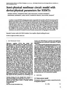
The model obtained for the radiometric and the geometric image formation process allowed the generation of synthetic SAR images of the test site that are very similar to the corresponding real images. This model was then inverted for both relief reconstruction and surface roughness characterisation applied to Venus. We developed a new method for relief reconstruction from SAR stereo imaging based on the use of gradient amplitude images. Our method relies on pre-processing the initial SAR stereo pair using an optimal gradient filter which was derived from the radar image formation model. This pre-processing allows to reduce speckle noise in SAR images and to enhance the images structures that are then used in the matching process. Experimental results show that our gradient based method produces better results than using original non-enhanced SAR images. As the improvement depends only on the pre-processing stage, the proposed method can be applied to any matching technique. Application of this gradient method to opposite-side stereo imaging is currently under study. It allowed us to generate some very accurate DEMs for rift zones (Beta Regio), craters and coronae (see Fig. 1). The surface roughness problem was also addressed using the so-called Integral Equation Model together with experimental data for Asal site. We obtained curves showing experimental relationships between the backscattered power and the local incidence angle for L, S, C and Xbands, for several geological formation of the Asal rift. Analysis of these results shows that, besides the strongest relief effect, roughness and dielectric properties of the surface influence first the power level and second the dropping angle of these curves, and that some information can be derived from the mutual arrangement of the multi-frequency data. The presented curves show in particular that the higher level of backscattering corresponds to the shorter wavelength band for all types of surfaces. As expected, considering data from individual bands allows to separate a limited number of geological formations, whereas taking into account two or more bands allows to separate nearly all considered materials. We are currently developing an inversion process combining multi-incidence radar images that could be applied to venusian lava flows for roughness characterisation.
Lunar and Planetary Science XXIX
1210.pdf
Extraction of Planetary Surfaces Physical Parameters using Radar Remote Sensing Ph. Paillou, Ph. Masson, V. Ansan, Th. Souriot, I. Elizavetin
Fig. 1. : Perspective view of Atseestan coronae (Ovda Regio, 8.5N92E) combining Magellan SAR image and stereo generated DEM.
References
I. Elizavetin, Ph. Paillou, "Experimental Study of an Arid Volcanic Region using S-band Radar Image Simulation", Earth Research from Space, Russian Academy of Science, 1997, accepted. I. Elizavetin, Ph. Paillou, "Study of surface scattering properties in S-band using radar image simulation", International Radar Conference RADAR-97, Edinburgh, Scotland, october 1997. Ph. Paillou, I. Elizavetin, "Surface characterization in arid volcanic regions using radar remote sensing", Seventh International ISPRS Symposium - Physical Measurements and Signatures in Remote Sensing, Courchevel, France, april 1997. Ph. Paillou, Ph. Masson, T. Souriot, "A comparative study of terrestrial rifts (Djibouti) and venusian rifts (Atla Regio) using radar remote sensing", Symposium INSUISERT-Université d'Addis Abeba "Volcanism, rifting and paleoclimates in the Ethiopian rift and Afar depression", Addis Abeba, Ethiopie, february 1997.
Ph. Paillou, "Dectecting Step Edges in Noisy SAR Images: A New Linear Operator", IEEE Transactions on Geoscience and Remote Sensing, 35(1), pp. 191-196, 1997. V. Ansan, P. Vergely, Ph. Masson, "Formation of Ishtar Terra, Venus", Planetary and Space Sciences, 44, 8, pp. 817-831, 1996. J. Shen, Ph. Paillou, "Trinocular Stereovision by Generalized Hough Transform", Pattern Recognition, 29(10), pp. 1661-1672, 1996. Ph. Paillou, "A Comparative Study of Venus Surface using Radar Remote Sensing", IEEE/CNES Int. Symposium on Retrieval of Bio-and Geophysical Parameters from SAR Data for Land Applications, Toulouse, France, october 1995. V. Ansan., P. Vergely, Ph. Masson, "Tectonic interpretations of Central Ishtar Terra (Venus) fromVenera 15/16 and Magellan full-resolution radar images", Planetary and Space Sciences, 42, 3, pp. 239-261, 1994.