In recent years, remote sensing (RS) has taken a significant technological leap forward. ...... Astrup, R., Bollandsås, O.M., Næsset, E. & Weydahl, D. J. 2010a.
Dissertationes Forestales 144
Forest mapping and monitoring using active 3D remote sensing
Mikko Vastaranta Department of Forest Sciences Faculty of Agriculture and Forestry University of Helsinki
Academic dissertation To be presented with the permission of the Faculty of Agriculture and Forestry, University of Helsinki, for public criticism in the Lecture Hall B6, Building of Forest Sciences, Latokartanonkaari 7, Helsinki on June 8th, 2012 at 12 o’clock noon.
2 Title of dissertation: Forest mapping and monitoring using active 3D remote sensing
Author: Mikko Vastaranta
Dissertationes Forestales 144
Thesis supervisors: Prof. Markus Holopainen Department of Forest Sciences, University of Helsinki, Finland Prof. Juha Hyyppä Finnish Geodetic Institute, Finland Adjunct Prof. Hannu Hyyppä Research Institute of Measuring and Modelling for the Built Environment, Aalto University, Finland Dr. Mika Karjalainen Finnish Geodetic Institute, Finland
Pre-examiners: Prof. Barbara Koch Department of Remote Sensing and Landscape Information Systems, University of Freiburg, Germany Prof. Håkan Olsson Department of Forest Resource Management, Swedish University of Agricultural Sciences
Opponent: Prof. Timo Tokola School of Forest Sciences, University of Eastern Finland
ISSN 1795-7389 ISBN 978-951-651-378-5
(2012)
Publishers: Finnish Society of Forest Science Finnish Forest Research Institute Faculty of Agriculture and Forestry of the University of Helsinki School of Forest Sciences of the University of Eastern Finland
Editorial Office: The Finnish Society of Forest Science P.O. Box 18, FI-01301 Vantaa, Finland http://www.metla.fi/dissertationes
3 Vastaranta, M. 2012. Forest mapping and monitoring using active 3D remote sensing. Dissertationes Forestales 144. 45p. Available at http:/www.metla.fi/dissertationes/df144.htm.
ABSTRACT The main aim in forest mapping and monitoring is to produce accurate information for forest managers with the use of efficient methodologies. For example, it is important to locate harvesting sites and stands where forest operations should be carried out as well as to provide updates regarding forest growth, among other changes in forest structure. In recent years, remote sensing (RS) has taken a significant technological leap forward. It has become possible to acquire three-dimensional (3D), spatially accurate information from forest resources using active RS methods. In practical applications, mainly 3D information produced by airborne laser scanning (ALS) has opened up groundbreaking potential in natural resource mapping and monitoring. In addition to ALS, new satellite radars are also capable of acquiring spatially accurate 3D information. The main objectives of the present study were to develop 3D RS methodologies for large-area forest mapping and monitoring applications. In substudy I, we aim to map harvesting sites, while in substudy II, we monitor changes in the forest canopy structure. In studies III-V, efficient mapping and monitoring applications were developed and tested. In substudy I, we predicted plot-level thinning maturity within the next 10-year planning period. Stands requiring immediate thinning were located with an overall accuracy of 83%-86% depending on the prediction method applied. The respective prediction accuracy for stands reaching thinning maturity within the next 10 years was 70%-79%. Substudy II addressed natural disturbance monitoring that could be linked to forest management planning when an ALS time series is available. The accuracy of the damaged canopy cover area estimate varied between -16.4% to 5.4%. Substudy II showed that changes in the forest canopy structure can be monitored with a rather straightforward method by contrasting bi-temporal canopy height models. In substudy III, we developed a RS-based forest inventory method where single-tree RS is used to acquire modelling data needed in area-based predictions. The method uses ALS data and is capable of producing accurate stand variable estimates even at the sub-compartment level. The developed method could be applied in areas with sparse road networks or when the costs of fieldwork must be minimized. The method is especially suitable for largearea biomass or stem volume mapping. Based on substudy IV, the use of stereo synthetic aperture radar (SAR) satellite data in the prediction of plotlevel forest variables appears to be promising for large-area applications. In the best case, the plot-level stem volume (VOL) was predicted with a relative error (RMSE%) of 34.9%. Typically, such a high level of prediction accuracy cannot be obtained using spaceborne RS data. Then, in substudy V, we compared the aboveground biomass and VOL estimates derived by radargrammetry to the ALS estimates. The difference between the estimation accuracy of ALS–based and TerraSAR X–based features was smaller than in any previous study in which ALS and different kinds of SAR materials have been compared. In this thesis, forest mapping and monitoring applications using active 3D RS were developed. Spatially accurate 3D RS enables the mapping of harvesting sites, the monitoring of changes in the canopy structure and even the making of a fully RS-based forest inventory. ALS is carried out at relatively low altitudes, which makes it relatively expensive per area unit, and other RS materials are still needed. Spaceborne stereo radargrammetry proved to be a promising technique to acquire additional 3D RS data efficiently as long as an accurate digital terrain model is available as a ground-surface reference.
Keywords: Forest inventory, forest management, laser scanning, LiDAR, synthetic aperture radar, radargrammetry
4
ACKNOWLEDGEMENTS
First of all, I want to thank my supervisors, Markus, Juha, Hannu, and Mika, for all of their support and encouragement. I have been extremely fortunate to have supervisors that prefer the “carrot” instead of the “stick”. My funding was always secured by your Finnish Academy projects (“Improving the Forest Supply Chain by Means of Advanced Laser Measurements” and “Science and Technology towards Precision Forestry”), which allowed me to concentrate on my thesis. Competent co-authors, of which I have had many, are needed to guide a doctoral student. I warmly thank my co-authors for their valuable collaboration; without your help, the thesis would not have been possible or, at least, would have taken much longer. The work was carried out at the University of Helsinki, Department of Forest Sciences, but in tight and fruitful cooperation with the Finnish Geodetic Institute and Aalto University. This has been an excellent research environment. Professor Barbara Koch at the Albert-Ludwigs University of Freiburg and Professor Håkan Olsson at the Swedish University of Agricultural Sciences (SLU) have reviewed the thesis. I thank them for their valuable comments and suggestions. I want to also thank all of my colleagues, friends, and parents for their support during the thesis. And I would like to add a special thanks to Noora, who had the patience to listen to all of my thesis-related highs and lows.
Viikki, May 2012
Mikko Vastaranta
5
LIST OF ORIGINAL ARTICLES This thesis consists of an introductory review followed by 5 research articles. Articles I-IV are reprinted with kind permission of the publishers, while article V is the author’s version of the submitted manuscript. I
Vastaranta, M., Holopainen, M., Yu, X., Hyyppä, J., Hyyppä, H. and Viitala, R. 2011. Predicting stand-thinning maturity from airborne laser scanning data. Scandinavian Journal of Forest Research 26 (2):187 196. DOI: 10.1080/02827581.2010.547870.
II
Vastaranta, M., Korpela, I., Uotila, A., Hovi, A. and Holopainen, M. 2012. Mapping of snowdamaged trees in bi-temporal airborne LiDAR data. European Journal of Forest Research 131 (4): 1217 1228. DOI: 10.1007/s10342-011-0593-2.
III
Vastaranta, M., Kankare, V., Holopainen, M., Yu, X., Hyyppä, J. and Hyyppä, H. 2012. Combination of individual tree detection and area-based approach in imputation of forest variables using airborne laser data. ISPRS Journal of Photogrammetry and Remote Sensing 67: 73 79. DOI: 10.1016/j.isprsjprs.2011.10.006.
IV
Karjalainen, M., Kankare, V., Vastaranta, M., Holopainen, M. and Hyyppä, J. 2012. Prediction of plot-level forest variables using TerraSAR-X stereo SAR data. Remote Sensing of Environment 117: 338 347. DOI: 10.1016/j.rse.2011.10.008.
V
Vastaranta, M., Holopainen, M., Karjalainen, M., Kankare, V., Hyyppä, J. and Kaasalainen, S. 2012. TerraSAR-X stereo radargrammetry and airborne scanning LiDAR height metrics in the imputation of forest above-ground biomass and stem volume. Manuscript.
Authors’ contributions Mikko Vastaranta was the main author of articles I, II, and V. In article III, Mikko Vastaranta was the main author, along with Ville Kankare. In article IV, Mikko Vastaranta was responsible for the data collection, analyses and writing, along with Mika Karjalainen and Ville Kankare. All the articles were improved by the contributions of the co-authors at various stages of the analysis and writing process.
6
TABLE OF CONTENTS ABSTRACT................................................................................................................................................................... 3 ACKNOWLEDGMENTS............................................................................................................................................. 4 LIST OF ORIGINAL ARTICLES................................................................................................................................. 5 ABBREVIATIONS................................................................................................................................................ 7 INTRODUCTION ................................................................................................................................................. 9 BACKGROUND ................................................................................................................................................... 9 OBJECTIVES OF THE STUDY .............................................................................................................................. 10 LASER SCANNING ............................................................................................................................................ 11 Laser scanning in measuring forests .......................................................................................................... 11 Estimation of stand variables using an area-based approach...................................................................... 12 Estimation of stand and tree variables with individual tree detection .......................................................... 13 Estimation of stand variables using a tree cluster approach ....................................................................... 14 Predicting forest growth and site type ........................................................................................................ 14 Mapping and monitoring of forest management operations ........................................................................ 15 Forest biomass and disturbance monitoring ............................................................................................... 16 Large-area inventories .............................................................................................................................. 17 Acquisition of tree-wise field data using laser scanning.............................................................................. 17 SATELLITE SAR IMAGING ................................................................................................................................ 19 Overview of relevant satellite SAR imaging techniques............................................................................... 19 SAR in forest mapping and monitoring....................................................................................................... 20 MATERIALS ...................................................................................................................................................... 22 FIELD DATA..................................................................................................................................................... 22 Evo ........................................................................................................................................................... 22 Hyytiälä .................................................................................................................................................... 22 Espoonlahti ............................................................................................................................................... 23 REMOTE SENSING DATA ................................................................................................................................... 23 Airborne laser scanning............................................................................................................................. 23 Synthetic aperture radar ............................................................................................................................ 24 THEORETICAL OVERVIEW OF THE METHODOLOGIES USED................................................................... 25 THE PROCESSING OF AIRBORNE LASER SCANNING DATA .................................................................................... 25 Creation of terrain, surface, and canopy height models .............................................................................. 25 Feature extraction unit .............................................................................................................................. 25 Geometric features .................................................................................................................................... 26 Vertical point height distributions .............................................................................................................. 26 THE RADARGRAMMETRIC PROCESSING OF SAR DATA ....................................................................................... 26 Extraction of point clouds from SAR stereo data ........................................................................................ 26 Obtaining above-ground elevations and predictor features from 3D points measured with radargrammetry 26 AREA-BASED APPROACH .................................................................................................................................. 27 INDIVIDUAL TREE DETECTION .......................................................................................................................... 28 MULTITEMPORAL ACTIVE 3D REMOTE SENSING DATA ....................................................................................... 29 EVALUATION OF RESULTS ................................................................................................................................ 30 RESULTS AND DISCUSSION OF THE SEPARATE STUDIES......................................................................... 31 PREDICTING STAND-THINNING MATURITY FROM AIRBORNE LASER SCANNING DATA ........................................... 31 MAPPING OF SNOW-DAMAGED TREES IN BITEMPORAL AIRBORNE DATA .............................................................. 31 COMBINATION OF INDIVIDUAL TREE DETECTION AND AREA-BASED APPROACH IN IMPUTATION OF FOREST VARIABLES USING AIRBORNE LASER DATA ........................................................................................................ 33 PREDICTION OF PLOT-LEVEL FOREST VARIABLES USING TERRASAR-X STEREO SAR DATA................................. 34 TERRASAR-X STEREO RADARGRAMMETRY AND AIRBORNE SCANNING LIDAR HEIGHT METRICS IN THE IMPUTATION OF FOREST ABOVE-GROUND BIOMASS AND STEM VOLUME .............................................................. 35 CONCLUSIONS.................................................................................................................................................. 36 REFERENCES .................................................................................................................................................... 38
7
ABBREVIATIONS 2D; 3D ABA AGB AGL ALOS ALS; LS a.s.l. AVNIR BA CHM CIR COSMO CTP DCPA DEM Dg DTM DSM dbh ERS FI GPS GNSS Hg InSAR ITD ITC JERS LAI LASSO LiDAR LVIS MGD MLS MSN NFI NN PALS PALSAR Pol-InSAR R2 RF REDD RMSE RS SAR SPOT SWFI TanDEM-X TCA TLS UTC VHF VOL WGS
2-dimensional; 3-dimensional Area-based approach Aboveground biomass Above ground level Advanced Land Observation Satellite Airborne laser scanning; Laser scanning Above sea level Advanced Visible and Near Infrared Radiometer Basal area Canopy height model Colour infrared Constellation of small satellites for the Mediterranean basin observation Canopy transparency parameter Damaged crown projection area Digital elevation model Mean diameter Digital terrain model Digital surface model Diameter-at-breast height European Remote Sensing Satellite Forest inventory Global Positioning System Global Navigation Satellite System Mean height Interferometric Synthetic Aperture Radar Individual tree detection Individual crown approach, e.g. ITD Japanese Earth Resources Satellite Leaf Area Index Least absolute shrinkage and selection operator Light detection and ranging Laser Vegetation Imaging Sensor Multilook Ground Range Detected Mobile laser scanning Most similar neighbour National forest inventory Nearest neighbour Profiling airborne laser system The Phased Array type L-band Synthetic Aperture Radar L-band polarimetric and interferometric SAR The coefficient of determination Random forest Reducing Emissions from Deforestation and Forest Degradation Root mean squared error Remote sensing Synthetic aperture radar Système Pour l’Observation de la Terre Stand-wise field inventory TerraSAR-X-Add-on for Digital Elevation Measurements Tree cluster approach Terrestrial laser scanning Universal Time, Coordinated Very high frequency stem volume World Geodetic System
8
9
INTRODUCTION
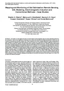
Background Forests are mapped and monitored for multiple purposes. Forest resource information is gathered for large-scale strategic planning, operative forest management and pre-harvest planning. National forest inventories (NFIs) are examples of inventories undertaken for large-scale strategic planning for gathering information about nationwide forest resources, such as growing stock volume, forest cover, growth and yield, biomass, carbon balance and largescale wood procurement potential. In NFIs, it is important to have unbiased estimates and obtain information also from small strata. The making of inventories of forest resources has a long tradition in Finnish forest sciences, making it among the first countries in the world to take such measures: a sampling-based forest inventory covering the whole country was introduced over 90 years ago (NFI 1, 1920-1924). Finnish foresters were also pioneers in developing new inventory methodologies when the making of multisource forest inventories was introduced in the early 1990s (Kilkki and Päivinen 1987, Tokola 1988, Muinonen and Tokola 1990, Tomppo 1991). However, operational forest management planning has been based on stand-wise field inventory (SWFI) for over 60 years in Finland. The potential of remote sensing (RS), such as the utilization of satellite – radar – and aerial images in the estimation of forest variables has been studied intensively, but the methodologies have not become generally used in practice. The reason is simple: the accuracy obtained in forest variable estimation at the stand level using RS data has not been adequate for forest management or pre-harvest planning. During the last decade, RS has taken a significant technological leap forward, as it became possible to acquire three-dimensional (3D), spatially accurate information from forest resources using active RS methods. In practical applications, mainly airborne laser scanning (ALS) has opened up groundbreaking potential in natural resource mapping and monitoring (see Figure 1). ALS collects 3D information from forest resources, which enables a highly accurate estimation of tree or stand variables. For example, estimated root mean square error (RMSE) accuracies for total volume have ranged between 10% and 20% at the stand level in the Nordic countries (Næsset et al. 2004).
Figure 1. Principle of airborne laser scanning.©Ville Kankare.
10 ALS surveys are carried out at relatively low altitudes, usually from 0.5 to 3 km, which makes it relatively expensive per area unit. Other remotely sensed data will still be needed, especially when updated information is required annually. In addition to ALS, satellite radars, launched in recent years, are also capable of acquiring detailed 3D information for forest mapping and monitoring. Synthetic aperture radar (SAR) is a special case of imaging radars being able to provide images with the spatial resolution of about one meter from satellites, which are orbiting at an altitude of several hundreds of kilometers. An overview of the use of ALS, SAR, and hyperspectral remote sensing data for forest assessment can be found in Koch (2010). Forest mapping and monitoring is carried out to support decision making by the forest owner. In operative forest management planning, input data have been traditionally gathered using SWFI. In SWFI, wood procurement potential, the amount of round wood removal and forest management proposals are mapped and determined. In addition to stand variables, site types are classified to map forest growth potential, the thinning regime, and biodiversity. Forest growth and yield are also highly correlated with forest estate value. The wood procurement chain from forest to users starts with knowledge of the stands available for harvesting. The accuracy of the SWFI data has not been adequate for mapping the thinning and final cutting sites, causing additional field work. In addition, preharvest measurements have been carried out separately based on existing SWFI. In Finland, rather expensive SWFI endeavours have been carried out once every 10 years. In this case, updated forest resource information for the intermediate years is predicted using growth models. Another option is to use continuous updating in forest management, where forest stands are inventoried after each operation and the growth between operations is updated using growth models. However, neither of these methods provides an efficient means to monitor rapid changes in the forests. Currently, the retrieval of stand variables, which is needed in forest management planning, is being replaced by ALS-based inventory methodologies in the Nordic countries. Relatively new ALS-based inventory methodologies were adopted quickly after the first promising studies (e.g. Nilsson 1996, Næsset 1997a, b, 2002, Hyyppä and Inkinen 1999, Hyyppä and Hyyppä 1999). The first operational test (6000 ha) in which an ALS-based inventory was carried out occurred in Norway in 2001. This test was followed by the first commercial contract for 46 000 ha in 2002. Various operational tests were carried out in Finland and Sweden during 2003 and 2004. In 2008, UPMKymmene acquired ALS data covering 450 000 ha of its forests. Forest inventories using ALS in privately-owned forests were first undertaken in 2010 in Finland, and by the end of 2011, almost 5 million ha had been scanned. In operational wall-to-wall forest inventories, a two-stage procedure using ALS data and field plots, i.e. an areabased approach (ABA, Næsset 2002), has become common and a reference against which other inventory methodologies are compared. The foremost advantages of the state-of-the-art ABA compared to traditional SWFI are more precise prediction of forest variables and sampling-based estimation with the possibility of calculation accuracy statistics, and, at least in principle, ALS-based inventory does not depend on stand boundaries. Although current ALS data acquisition and processing costs are lower than that of traditional SWFI methods, ALS data is expensive compared to many other RS materials, and it is currently used mainly for the retrieval of basic forest inventory variables. Thus, improved means are needed to utilize it more efficiently in forest resource management, especially for large areas. The mapping of potential harvesting sites is one of the key decisions for large-scale forest owners (Laamanen and Kangas 2012). Furthermore, monitoring applications related to forest growth and the mapping of natural hazards are required at varying scales. In large-area wall-to-wall applications, efficient methods are needed for accurate stem volume and biomass mapping. Thus, the fusion of ALS with other RS materials must be considered. This thesis contributes to these subjects.
Objectives of the study The main aim in forest mapping is to produce accurate information from forest resources for forest managers with efficient methodologies. Methods are needed to monitor forest growth, among other changes in forest biomass, e.g. natural hazards and disturbances as well. The objectives of the present study were to develop active 3D RS methodologies for large-area forest mapping and monitoring applications. In substudy I, we aim to map harvesting sites, while in substudy II, we monitor forest canopy changes using ALS data. In substudy III, an efficient mapping application is developed using ALS data. In substudy IV, a method for the area-based mapping of forest variables is developed using radargrammetric 3D measurements, while in substudy V, the developed method is tested against state-of-the-art area-based estimation using ALS data. The specific objectives of studies I-V were as follows: I
An area-based approach is currently used in operational forest management planning inventory. Still, forest management proposals are made in the field by foresters. Here, we demonstrate a method to predict stand thinning maturity using ALS data. The method can be used for the mapping of harvesting sites.
11
II
Multitemporal, spatially accurate 3D RS data sets are becoming more general, which enables novel monitoring applications. Here, we present a method for monitoring changes in the forest canopy structure using bitemporal ALS data.
III
Single-tree remote sensing could be used to acquire the modelling data needed in ABA. Here, we demonstrate a fully RS-based forest inventory method. The method uses ALS data and is capable of producing accurate stand variable estimates even at the sub-compartment level.
IV
Airborne laser scanning is relatively expensive per area unit compared to spaceborne RS data. Thus, other remotely sensed data will still be needed, especially in monitoring applications requiring high temporal resolution. A promising approach to map and monitor forest resources by radar imaging is radargrammetry. Here, we develop a radargrammetry-based method to predict plot-level forest variables.
V
Here, we compare 3D information derived by ALS and radargrammetry to predict stem volume and biomass.
Laser scanning Laser scanning in measuring forests Laser scanning (LiDAR, Light Detection and Ranging; LS, Laser Scanning) is an active RS technique that uses the time-of-flight measurement principle to measure the distance to an object. With the known position of the sensor and precise orientation of these range measurements between the sensor and a reflecting object, the position (x, y, z) of an object is defined. The principle of LS measurements is the same regardless of the placement of the scanner. In forest mapping, the most frequently applied method is laser scanning done from an aircraft (ALS). Mobile and terrestrial laser scanning (MLS, TLS) have so far been used mainly for research purposes. From the forest mapping point of view, MLS could be linked to a logging machine to collect tree quality data, while TLS could be used in acquiring a plot-level reference. In this thesis, the applications of ALS are studied and MLS and TLS applications are discussed. The instruments used for ALS forest inventory purposes typically emit very short (3-10 ns), narrowbeamwidth (0.15-2.0 mrad), infrared (0.80-1.55 m) laser pulses at near-nadir incidence angles (