276
Geodesign as a Process: From Modelling to Enactment Michele CAMPAGNA Università di Cagliari/Italy ·
[email protected]
Abstract This paper concerns the perspective of Geodesign as a process. As such, the Geodesign process should be carefully designed and managed. To address this issue the concept of metaplanning is proposed in a novel way for its operational implementation relying on Business Process Management methods and tools. This approach, is argued in the paper, may improve both the process and the development of supporting technology, opening the path towards 2nd generation process-oriented Planning Support Systems.
1
Introduction
Much attention in the current Geodesign debate is given to the implementation of single “Geodesign methods”, or to technology, or to case studies (MCELVANEY 2012, LEE et al. 2014) from a substantive perspective. To a lesser extent more comprehensive proposals are given to address the overall Geodesign process from more theoretical and methodological perspectives. As a notable exception, the STEINITZ’s Framework for Geodesign (2012) may be considered a comprehensive formalization of Geodesign concepts including sound integrated theories, methods and principles for analysis, design, and choice. On the base of this framework, more research should be devoted to the formalization and operationalization of Geodesign concepts which may help to the application of the framework in practice. Among other issues which may deserve more research attention, the second iteration in the STEINITZ’s Geodesign Framework is a crucial aspect entailing the concept of Geodesign as a process in its entirety. In the second iteration, the Geodesign process is designed in detail before its implementation in the third iteration. In other words, the second iteration concerns the design of the Geodesign process (i.e. meta-design) or, if we apply the concept to spatial planning, it concerns the action of metaplanning. As such the second iteration may become one of the most critical elements of the overall process. In the light of these premises, in the next section the concept of metaplanning is defined with reference to three main issues: i) its potential benefits to the planning process; ii) its practical operationalization through planning process modelling; iii) the design and the implementation of process-oriented Planning Support Systems (PSS). The latter two issues are further explored in section 3 and 4. A final discussion with issues for further research development in metaplanning and process-orientation in PSS is given in Section 5.
Buhmann, E., Ervin, S. M. & Pietsch, M. (Eds.) (2015): Peer Reviewed Proceedings of Digital Landscape Architecture 2015 at Anhalt University of Applied Sciences. © Herbert Wichmann Verlag, VDE VERLAG GMBH, Berlin/Offenbach. ISBN 978-3-87907-555-3. This article is an open access article distributed under the terms and conditions of the Creative Commons Attribution license (http://creativecommons.org/licenses/by/3.0/).
Geodesign as a Process: From Modelling to Enactment
2
277
Metaplanning
Metaplanning can be defined as the design of the planning process. The concept has been applied since the 1970s in many disciplines including management science, artificial intelligence, and system engineering. The idea of spatial planning as a process is not new in planning theory either. An early definition of metaplanning and its potential benefits with regards to spatial planning processes were given by de Betterncourt et al. in 1982. According to them, metaplanning consists of an “explicit effort to identify plan users, characterise their interest and needs, and design the planning process accordingly to meet them”. As such metaplanning -which in some cases may be a simple, quick and inexpensive effort, while in some other cases may require larger use of time and resources- should be an integral part of any planning process or task. Benefits of metaplanning may include a better understanding of the process among stakeholders, more responsive outcomes to the users of the process results, and increased transparency and accountability of planning and design decisions. This way, the efficacy of a planning process could be measured not only in terms of substantive objectives (i.e. how far future scenarios expressed by the plan will be realised) but also in term of procedural or instrumental ones (i.e. when, why, how, and by whom decisions were made). The latter perspective while central for Strategic Environmental Assessment (Directive 2001/42/EC) (THERIVEL & PARTIDARIO 1996, THERIVEL 2004) is often poorly addressed in practice. The exercise of metaplanning should start identifying who are the participants, or actors, in the process, and thereafter what are the main activities, and their sequence. In general, the choice may depend on the overall objectives of the decision-makers, and can be influenced by the planner’s advice, by normative requirements, or by participatory initiatives. The choice of the participants to a planning process should also be as inclusive and formalised as possible for lack of stakeholders acknowledgement in the process may challenge and undermine policies implementation (HEALEY 1997). Later, at a larger scale of details, metaplanning should also deal with how each activity is implemented in terms of methods, tools, input, output, as well as all the elements needed for the actual process implementation. The latter part is usually dealt with more attention in the geodesign literature. However, in real practices the definition of the latter elements is not always clear and understandable by those who participate to the process in first instance, and by those who may observe the process from the outside. Hence, two main issues may arise: misunderstandings among the actors, and lack of transparency and accountability to the public. From an operational perspective, Geodesign methods usually include a core geographic information science component, thus the definition of tasks, tools, input, and output should not be qualitative only. Hence, an operational approach for metaplanning, able to link the soft human components of the process to the hard computational one in a single working framework, is needed. In order to address these issues, the emerging discipline of Business Process Management (WESKE 2012) may offer reliable and user-friendly methods and tools for the planner to support the exercise of metaplanning. The results not only may help to reach metaplanning objectives, but also to support the construction of process-oriented PSS. To test this hypothesis, as-is and to-be planning process modelling for a number of selected examples from both planning theory and practice were tested by the author with the graphi-
278
M. Campagna
cal standard language Business Process Modelling and Notation (BPMN 2.0). This planning process modelling exercise with the standard BPMN language demonstrated it can be a reliable tool for the description of high level process models, as well as for their decomposition down to single activity sub-models (CAMPAGNA et al. 2014). Hence, this first experience demonstrated the modelling requirements of metaplanning can be accomplished with BPMN. As shown with simple illustrative examples in the next section, the planning process models in BPMN include actors, activities, their sequence and iterations, data objects, and other technology artefacts, which represent the main elements for a comprehensive representation of the process. Real world planning process models would be much more complex, hence difficult to be clearly represented in a book chapter format; rather the proposed examples are intended to offer to the reader a sense of the functioning of the basic constructs of the BPMN language and of its potential for planning process modelling in practice. Moreover, using Business Process Management Systems or Suites, it is possible to configure the planning process models associating the relevant data sources and technology tools to implement each task. A simplified example of configuration is also proposed aiming at illustrating how the models can be used to orchestrate the data (i.e. standard Web Features Services) and processing services (i.e. standard Web Processing Services) chaining by using a BPMS in order to supply technology tools to the relevant actors during the process execution. A pilot of the approach to BPM-based geo-information technology orchestration with more technical details, whose description is out of the scope of this paper, can be found in CAMPAGNA et al. (2014). Moreover, in section 4, more details are given showing the overall architecture of a PSS 2.0 platform design and implementation.
3
Planning Process Modelling
At the core of the metaplanning exercise stands the definition of the actors which formally or informally are considered to take part in the process. The definition of the network of the process participants is not predetermined; rather it may be affected by decision-makers objectives, by the planner’s technical considerations, and/or by regulations requirements. In some cases, depending on contextual conditions other interest groups or the wider community may be admitted to have their voice in the process (e.g. public consultations in strategic environmental assessment). Hence, in order to properly manage the process, it is of great importance to keep track of the roles and responsibilities in an integrated and formal way. In BPMN, an organization is graphically represented as a pool where different lanes represent different sectors and roles belonging to its organigram. The relationships among different organizations which collaborate in a process are expressed in BPMN through collaboration diagrams. The collaboration diagram in Figure 1 expresses, for example, the general relationships among planning actors and tasks in a given planning process. In this example, after the decision-makers make the decision that a new plan is needed, they give input to the planner, who carries out a geodesign study. In this example, the study is articulated according to the three iterations of the STEINITZ’s geodesign framework (2012), which in this case are called scoping, metaplanning, and implementation respectively. The collaboration with other participants from outside the organization is outlined by message flows (dashed lines) among them. In the example in Figure 1, interest groups and the community are called to participate at different stages of the process to specific activities and tasks: interest
Geodesign as a Process: From Modelling to Enactment
279
groups may give input in the scoping phase, while the public is invited to consultations before the plan will be adopted. In Figure 1, the exact activities which are to be performed by the interest groups and the community are not defined at this stage (i.e. black box) nor their internal organizations; from a strict metaplanning perspective, they may be or may be not further defined at a later stage.
Fig. 1: Example of a planning process model in BPMN: Collaboration diagram among the process actors (http://tiny.cc/qkg1ux)
Fig. 2: Example of a planning process model in BPMN: Rational Comprehensive Planning models (KHAKEE, 1998). Actors, activities, sequence and data objects exchange among them are represented in the model (http://tiny.cc/1mg1ux). Focusing in more details on how the planner and its team will be working for and in collaboration with elected or appointed decision-makers of a public authority, we can further specify the planning process models, for example, as in Figure 2. Also in this example, which is inspired by a theoretical rational comprehensive planning model (KHAKEE 1998), the process model is just one of the possible which may be adopted to make the plan. In the
280
M. Campagna
example in Figure 2, together with a more detailed specification of the activities carried on by each actor and the sequence flow, data objects (e.g. spatial data layers or data tables) are introduced to represent input and output of the activities. In the example in Figure 2, the “formulate plan proposals” is a complex task which can typically be implemented with a geodesign study. Hence, it can be expressed in detail, for example, as in Figure 3.
Fig. 3: To-be planning sub-process model in BPMN for the “formulate proposals” task (http://tiny.cc/nog1ux) The STEINITZ’s Geodesign Framework models have been chosen in order to implement the formulate proposals task. Each macro-activity (i.e. with ‘+’ sign) can be further decomposed and modelled with further detail in other diagrams, until it can be configured and enacted in a Business Process Management Systems. In Figure 4, the “represent territorial system” sub-task is further modelled. In the working scenario represented in the model, relevant data are selected by the planner, and then they are accessed automatically from the local Spatial Data Infrastructure as Web Feature Services (WFS). Data layers are then processed (e.g. projection and geo-processing) using Web Processing Services (WPS) in remote servers; afterwards they are saved in the project geodatabase.
Fig. 4: The “represent territorial system” activity model in BPMN (http://tiny.cc/lpg1ux) The models could be further detailed to express atomic tasks in more details. What it is intended to be demonstrated here, even through simple examples, is that a user-friendly language as BPMN may be used to express with varying degree of detail the planning process, starting from its main steps and decomposing it in activities down to elementary
Geodesign as a Process: From Modelling to Enactment
281
task, where single spatial data or processing services can be described and configured with implementation settings. In other words, with an the increasing level of details, to actors and activities more elements are added including data types and other ICT artifacts. The BPMN language itself does not suppport configuration settings representation, which however can be detailed in the BPMN editors of many BPMS (WESKE 2012). As briefly explained in the next section all these settings can be used to orchestrate the geo-information technology integration and to supply applications to the relevant users at run time.
4
Configuration and Enactment: Towards Process-oriented PSS
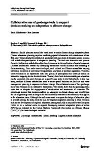
The diagram in Figure 5 shows a Business Process Management Systems architecture which may constitute the base for the development of process-oriented 2nd generation PSS. The overall scheme is fairly simple: the BPMN editor (top-left) is used to depict the planning process at hand from the general overview, down to the detailed models, as illustrated in the previous section. The planning process models are then saved in a digital repository (bottom-left), which constitutes the planning process knowledge base expressed in BPMN; in addition the actual configuration settings are also saved in the repository. A process engine (centre) reads the process models and their settings, and orchestrates their ordered execution integrating data and processing services and supplying them via interfaces to the relevant users. Early examples of the implementation of a spatially-enabled Business Process Management System was implemented by CAMPAGNA et al. (2014) demonstrating the functioning of the technology building blocks for the creation of a process-oriented 2nd generation PSS, or PSS 2.0 paradigm.
Fig. 5: Architecture of a process oriented 2nd generation PSS, or PSS 2.0 (http://tiny.cc/1qg1ux)
282
5
M. Campagna
Conclusion and Outlook
The examples proposed in this study are intended to show in a simple manner the potential for BPMN to become a reliable tool for planning process modelling, from high level to detailed descriptions, using a standard notation. The use of BPMN as a standard graphical notation for the representation of the process may help to achieve common understanding among actors, and the possibility to define the associations of digital (or analogues) tools to each activity or task, as well as, input and output data objects. Moreover, using Business Process Management Systems, planning process models can be saved and shared to be reused or adapted in other processes or for education purposes, contributing to the creation of planning and design processes knowledge bases. The research of BPM application in metaplanning and in PSS process-orientation is still in its infancy, though it seems to be promising. More work should be devoted to the creation of new planning process models representing both theoretical and real-world case studies, which may be used as templates to be adapted to new (meta) planning and design case studies, or in education to develop critical analysis on possible process unfolding and workflows. The operational advantages of using BPMN, compared to other modelling languages rely both in its reach semantics and in the possibility granted by Business Process Management Systems, to convert BPMN models to other languages, such as Business Process Execution Language, or BPEL, which are machine readable and can be used to orchestrate the planning supporting technologies. A number of issues and research questions are still open. They definitely deal with how to possibly include planning process ontology knowledge on geodesign actors, methods, and tools within planning process management systems; however the examples shown in synthesis in this paper may show a possible way towards. Building this knowledge, and applying it in a metaplanning exercise, may be done by an expert action, or could be socially constructed with collaborative, or even crowdsourcing, initiatives thanks to current BPM software. We may be not there yet to achieve a kind of expert system which may suggest the right methods or tools at the right time to the planner, but metaplanning and BPM may help to increase the awareness about the process perspective in geodesign education and practice. The latter would result in more organised, understood, transparent, and accountable planning process, which if not more, would be an added-value to many real-world practices that so often, notwithstanding the innovative drive brought by Strategic Environmental Assessment, still lack of environmentally-informed and democratic decision-making.
Acknowledgments The work presented in this chapter was developed by the author within the research project “Efficacia ed efficienza della governance paesaggistica e territoriale in Sardegna: il ruolo della VAS e delle IDT” [Efficacy and efficiency of landscape and environmental management in Sardinia: the role of SEA and of SDI] CUP: J81J11001420007 funded by the Au-
Geodesign as a Process: From Modelling to Enactment
283
tonomous Region of Sardinia under the Regional Law n° 7/2007 "Promozione della ricerca scientifica e dell'innovazione tecnologica in Sardegna".
References CAMPAGNA, M., IVANOV, K. & MASSA, P. (2014), Implementing metaplanning with Business Process Management. Procedia Environmental Science, 22, 199-209. DEBETTENCOURT, J. S., MANDELL, M. B., POLZIN, S. E., SAUTER, S. L. & SCHOFER, J. L. (1982), Making planning more responsive to its users: the concept of metaplanning. Environment and Planning A, 14 (3), 311-322. HEALEY, P. (1997), Collaborative Planning: shaping places in fragmented societies. MacMillan Press LTD, London. KHAKEE, A. (1998), Evaluation and planning: inseparable concepts. Town Planning Review, 69 (4), 359-374. LEE, D., DIAS, E. & SCHOLTEN, H. (Eds.) (2014), Geodesign by Integrating Design and Geospatial Sciences. Springer. ISBN 978-3-319-08298-1. MCELVANEY, S. (2012), Geodesign: Case Studies in Regional and Urban. ESRI Press, Redlands, CA. STEINITZ, C. (2012), A frame work for Geodesign. ESRI Press, Redlands, CA. THERIVEL, R. (2004), Strategic environmental assessment in action. Earthscan, London. THERIVEL, R. & PARTIDARIO, M. (1996) The practice of strategic environmental assessment. Earthscan, London. WESKE, M. (2012), Business Process Management: Concepts, Languages, Architectures. Springer, Berlin/Heidelberg.