Tecate, USA, and Tecate, Mexico, located in the Tijuana River Watershed .... about 15 classes; or the San Diego-Tijuana Border Planning Atlas (IRSC 2000).
GIS-BASED DECISION SUPPORT SYSTEM FOR TECATE, USA AND TECATE, MEXICO PROJECT NUMBER: EIR-05-03 RICHARD D. WRIGHT, SAN DIEGO STATE UNIVERSITY KATHERINE COMER, SAN DIEGO STATE UNIVERSITY JOSÉ LUIS FERMÁN, AUTONOMOUS UNIVERSITY OF BAJA CALIFORNIA, ENSENADA OSCAR ARIZPE, AUTONOMOUS UNIVERSITY OF BAJA CALIFORNIA SUR, LA PAZ NARRATIVE SUMMARY Tecate, USA, and Tecate, Mexico, located in the Tijuana River Watershed along the California-Baja California section of the U.S.-Mexican border, exemplify small to mid-size urban pairs along the international border. One significant characteristic generally shared by these pairs is an inadequate geographic information infrastructure for supporting land use planning and other government decision making. The functioning of these governments can be made more efficient and effective if greater use is made of GIS and related geospatial technologies such as remote sensing and cartographic visualization. Crossborder interactions would also be facilitated if they could share a common transborder data set, knowledge base, and GIS tools for making decisions. This is especially important for planning related to the environment, including habitat and ecosystem conservation planning as well as watershed management. Although, the two Tecates is our primary test bed, we have also worked closely with colleagues from the Autonomous University of Baja California Sur and the Autonomous University of Baja California, Ensenada who are conducting comparable GIS projects in Mexico in La Paz, Loreto, and the coastal zone between Ensenada and Tijuana. The overall goal of this project is to better understand the issues associated with the creation of transborder GISs to assist stakeholders in addressing crossborder environmental problems. This is accomplished through the development of (a) common data standards for Tecate, U.S.A., Tecate, Mexico, and selected other urban places in Baja California; (b) the preparation of web-based tools to allow users to perform wide range of queries concerning the location, change over time, and spatial relationships of features such as population, land use, groundwater, and vegetation; (c) a metadata data catalog to enable users of the GIS to gain knowledge about the genealogy of different data layers in the database (e.g., sources of the data and methods employed to produce the data);
and (d) an example demonstration of the use of the GIS through the application of a flood risk model to the Tecate, Mexico, area.
GIS-BASED DECISION SUPPORT SYSTEM FOR TECATE, USA AND TECATE, MEXICO PROJECT NUMBER: EIR-05-03 RICHARD D. WRIGHT, SAN DIEGO STATE UNIVERSITY KATHERINE COMER, SAN DIEGO STATE UNIVERSITY JOSÉ LUIS FERMÁN, AUTONOMOUS UNIVERSITY OF BAJA CALIFORNIA, ENSENADA OSCAR ARIZPE, AUTONOMOUS UNIVERSITY OF BAJA CALIFORNIA SUR, LA PAZ INTRODUCTION The population of the U.S.-Mexican border is highly concentrated in a dozen urban pairs (Ganster 1998). These pairs exhibit many differences and similarities, but one significant characteristic generally shared by all, except for the largest members (e.g. San Diego and Mexicali), is an inadequate geographic information (GIS) infrastructure for supporting land use planning, water supply management, and other government decision making. The functioning of these governments can be made more efficient and effective if greater use is made of GIS and related geospatial technologies such as remote sensing, global positioning systems (GPS), and cartographic visualization. Cross-border cooperation can also be facilitated if the members of each pair would share a common transborder data set, knowledge base, and GIS tools for making decisions. The two Tecates (Tecate, Baja California, Mexico and Tecate, California, USA) are typical of many of these urban nodes in that they are characterized by rapid population growth that is outstripping scarce local water resources and infrastructure development (see figure 1).The population of Tecate, Mexico grew from 52,000 to 78,000 between 1990 and 2000; this is a growth rate of more than 4% annum (R. Cruz Piñero and E. Ybáñez Zepeda2000). Although Tecate, U.S.A. has fewer than 200 inhabitants, it is a significant border settlement because of its location next to Tecate, Mexico, at a busy border crossing and the presence of substantial border-related commercial activities. Scarce potable water has been a limiting factor in its growth. Given the increasing stress on the border’s natural resources, it is essential that they be carefully managed and used wisely. With this project we developed a GIS database and associated web site that allows decision makers to more effectively manage resources and develop policies that will lead to improved local sustainability. Although the two Tecates is our primary testbed, we have also worked closely with colleagues from the Autonomous University of Baja California Sur and the Autonomous University of Baja California, Ensenada who
are conducting comparable GIS projects in Mexico in La Paz, Loreto, and the coastal zone between Ensenada and Tijuana. Urban governments in small Mexican cities generally lack the resources and expertise, including continuity of personnel, to maintain GIS as a planning tool. Mexican municipal administrations change every three years and there is no reelection. Thus, the challenges of deploying GIS as a planning tool for small Mexican cities are significant. At the same time, transborder GIS databases would significantly enhance planning cooperation across the border. RESEARCH OBJECTIVES The overall goal of this project is to better understand the issues associated with the creation of transborder GISs to assist stakeholders in addressing crossborder environmental problems. This is accomplished through the development of (a) common data standards for Tecate, U.S.A., Tecate, Mexico, and selected other urban places in Baja California; (b) the preparation of web-based tools to allow users to perform a wide range of queries concerning the location, change over time, and spatial relationships of features such as population, land use, groundwater, and vegetation; (c) a metadata catalog to enable users of the GIS to gain knowledge about the genealogy of different data layers in the database (e.g., sources of the data and methods employed to produce the data); and (d) an example demonstration of the use of the GIS through the application of a flood risk model to the Tecate, Mexico, area. RESEARCH METHODOLOGY/APPROACHES The Project was accomplished in several phases or steps: Phase 1 – Inventory of Data availability The majority of the data available for this project was compiled, and in some cases modified, from previous research projects conducted in the Tijuana River Watershed. Principal among these studies are Wright (2002), Gersberg et al (2003), and Comer (2006). A list of data inventoried for this project is contained in Table1. Phase 2 – Database Development As is seen in Table 1, spatial data covering the Ambos Tecate area derive from different image types ( i.e., autocad files, satellite imagery, and existing maps) at different scales and resolution (i.e., 1:5,000 to 1:250,000 and 1m to 30m resolution) and at different times (i.e., between 1994 and 2001). The challenge for this project and previous GIS database projects covering the Tecate area was to integrate widely disparate data on a common georeferencing system.
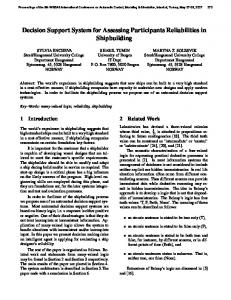
Phase 3 – Metadata Catalog Development The data compiled for the Ambos Tecates project are not only accessible to users in ArcGIS format but are well documented through metadata that are easily readable, transferable and accessible. The metadata can be viewed or downloaded from the main website. Included are descriptions about data formats, map projections, coordinate systems, collection dates, affiliated parties, and sources so that users can determine data accuracy and judge the degree of usefulness of project data. Table 2 is a data dictionary for the project in summary form. Phase 4 – Website Design and Construction The structure of the website is such that all related pages can be conveniently accessed from the main index page, which can be found at http://trw.sdsu.edu/tecate. It was built for simplicity and ease of use and includes a description of the Tecate project, as well as information on the use of the site and Internet Map Service (IMS). Figure 2 is an example screen shot from the website. The IMS was constructed using ESRI’s ArcIMS, which is internet software written to provide client to – and interaction with – GIS information without installation of expensive and often cumbersome GIS software. Users access the IMS through any html browser and make requests for viewing, identifying, and querying features. The interactive site allows users to view the Tecate region at a variety of scales and resolution, identify and search for features, obtain information about features, and click layers on and off according to need. User requests are sent to the main GIS server where spatial data processing is performed. The server then takes a “snapshot” of the results and sends it as a compressed image file to the client-side html browser. This limits the burden of processing on the client server and makes basic GIS functionality available to users anywhere on the Internet, even those with limited software and software resources. Phase 5 – Implementation and Maintenance of the Website and GIS Database The Ambos Tecate was installed and available on the Department of Geography server at San Diego State University. It was actively monitored and maintained until mid-2009 when the IMS components were removed as part of website revisions resulting from ADA compliance efforts at the university. Significant geospatial data remain on the Tijuana River Watershed website: http://trw.sdsu.edu Phase 6 – Example Application of the Tecate GIS As part of the Ambos Tecate project, the Autonomous University of Baja California, Ensenada, developed a pilot flood risk model. The model was
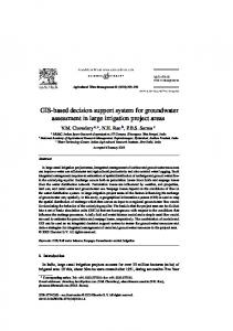
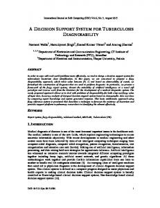
designed to use environmental and anthropogenic variables as inputs to identify probable high risk flooding areas in the urban area of Tecate, Baja California. The data used came primarily from the Tijuana River Watershed database. The base scale of the data was 1:50,000. The purpose of the model is to assist decision makers in addressing natural hazards, in this case flooding, when making public policy decisions. The model is designed to be relatively simple in order to maximize the applicability to other data poor urban areas. While the Tijuana River Watershed database is quite comprehensive, the data integration process resulted in a coarse data scale. The model designers acknowledged the issue of data availability and coarseness by developing a model that would accommodate these restrictions. The model develops a Flood Risk Index (FRI) by utilizing a Hazard Index and Vulnerability Index (See Figure 2). The Hazard Index (HI) is comprised of slope, stream location and geomorphology environmental variables. The Vulnerability Index (VI) is comprised of land use types. Weights are assigned to each input variable depending upon its value and location. These weights are totaled and classified into high, medium or low risk. Figure 3 shows the results when the model is applied to Tecate. The flood risk model developed for the Ambos Tecate project is a pilot model. The authors at the Autonomous University of Baja California, Ensenada, have plans to refine and extend the model to include measures for estimated damage. They have also applied the model in the Ensenada, Mexico, area. PROBLEMS/ISSUES ENCOUNTERED The binational aspect added to the complexity of the project. For example, Mexico often uses maps derived from AutoCAD files. These are drawings in electronic format regularly used by engineers, and in this case, many of the maps were out of date and had errors. When the drawings were converted to GIS, they significantly sped up the GIS digitization process. The conversion of AutoCAD files to shapefiles has not been used extensively in this area of the U.S.-Mexican border because it is time consuming to do. However, it is a one-time task. Complete conversion of AutoCAD files to GIS is an option that should be explored along the U.S.-Mexican border. A cost-benefit analysis of the investments in costs and labor should be compared with the potential technological gains and human capacity building of such a large project. The original AutoCAD land use maps varied in scale. We were wary of discarding the detailed block level land use information provided near the U.S. port of entry and central plaza of Tecate. However, for future border efforts we recommend scaling down to create a uniform working scale.
We did scale up with our land use classification, and recommend this approach for regional studies. Our intention with the land use map was to potentially apply it border wide and possibly binationally. We discussed using land use classes such as the original AutoCAD land use scheme (Municipality 2003), with 15 classes; the Tijuana River Watershed scheme (SDSU and COLEF 2005) with about 15 classes; or the San Diego-Tijuana Border Planning Atlas (IRSC 2000) with 8 classes. We chose to use the Border Planning Atlas’ scheme because it is binational, had a similar scale and extent, and because Tijuana and Tecate are rapidly merging. Three of the land use classes were not present in Tecate; therefore, we ended up with only five land use classes. Scaling up inevitably resulted in a loss of detailed information, as discussed above. The shortcoming of generalizing with five classes may be that municipal governments in Tecate will find it difficult to monitor subtle land use changes during their short three-year administrations. Moreover, the results from the application of models, such as the flood risk assessment, may not provide adequate spatial resolution to meet the requirements of urban planning. However, using fewer classes creates a map that is easier to interpret by a wider range of stakeholders, and its general nature also results in higher confidence in the data. Another issue is data integration among different years and scales. This problem was partially addressed by verifying that 1994 data from the Tijuana River Watershed project was consistent with the 2000 photo. However, the scale of the 1994 layers was 1:50,000, and therefore lacks the detail of layers digitized using the 1:24,000 NOAA photo mosaic. The problem could be addressed in future efforts by re-digitizing the 1994 layers. RESEARCH FINDINGS The findings of this research project can be summarized as follows: Data Standards It is possible to develop common spatial data standards for small to medium sized city pairs along the United States-Mexico border. However, transborder data integration must take into account that data typically differ in spatial and temporal resolution from one side of the border to the other. Web-Based Tools As a result of technological advances it has become much easier to develop transborder Web sites as illustrated by the Ambos Tecate project. Consequently, the preparation of a web site for making information to a broad range of stakeholders should be a standard requirement of all border research projects.
Metadata Catalog Although not always required of GIS research projects, the metadata catalog produced for this project demonstrates the importance of metadata to the prospective user of the data.
Example GIS Application The application of a flood risk model to flood prone Tecate, Mexico, demonstrates the utility of the Ambos Tecate GIS. However, the results of the modeling effort highlights the need for more highly resolved spatial data for localized as opposed to regional application. CONCLUSIONS In conclusion, this study has been concerned with the major impediments to the development of integrated GISs for twin cities along the U.S.-Mexican border. Technical impediments include variations in the quality, scale and resolution, temporal consistency, availability of data, as well as software and hardware comparability. Human impediments include cross border differences in education and training, priorities regarding data creation, legalities concerning ownership and access to data, differences in organization and management styles, and differences in funding support for GIS. Despite these cross-border variations, with the Ambos Tecate project, we were able to demonstrate the feasibility of creation integrated cross-border GISs for urban twins in the United StatesMexican border region. This study also underscores an important role that universities can play in facilitating improved environmental and land use planning in small Mexican municipalities. Specifically, small local governments in Mexico often lack the resources and technological skill to develop and maintain a GIS for planning purposes. Mexican border universities, in partnership with U.S. counterparts, are well situated to work with local governments in developing planning tools along and across the border. Development and maintenance of data sets, training, and tech transfer are all functions that universities are well equipped to do. RECOMMENDATIONS FOR FURTHER RESEARCH There is a need for substantial research involving improved database development, improved predictive models, greater standardization of geographic data, and a greater understanding of the factors influencing land development. Improved Database Development To support many types of research efforts such as those involving change detection and predictive modeling it is essential that the Tijuana River Watershed database of which the Tecate Creek Watershed database is a part, be improved with the addition of data derived from high resolution (4m-10m) satellite imagery. Also, the database should be upgraded by including data based on increased density of in site monitoring stations for collecting data on water quality, stream flow, precipitation, and other environmental variables.
Improved Predictive Models The development of improved predictive models is needed for a better understanding of such phenomena as urban expansion and population growth and their impacts on habitat fragmentation and other environmental conditions. Real time models for alerting stakeholders to disasters such as flooding should also be added to the geographic information system. Increased Data Standardization Agreement should be sought for improved standardization of geographic data. This will allow for a reduction in the time and cost of integrating disparate data sets back and forth across the border. Increased Understanding of the Role of Government Agencies in Land Development To more fully comprehend the causes of landscape change in border twins such as Ambos Tecate it is essential that an investigation be conducted on the effects of government (local, state, federal, and international) laws, ordinances, policies, and practices on land development. Currently, the differences between the United States and Mexico sections and their impacts are poorly understood. RESEARCH BENEFITS The principal benefits of this project are to make more information about Ambos Tecate available to stakeholders and to achieve a greater understanding of the challenges and solutions involved in integrating cross-border geographic data in border twin cities. ACKNOWLEDGEMENTS This work was sponsored by the Southwest Consortium for Environmental Research and Policy through a cooperative agreement with the U.S. Environmental Protection Agency (USEPA). Contact SCERP for further information through: www.scerp.org.
REFERENCES Comer, K. (2006), “Identification and Mapping of Potential Ground Water Contamination Sources in Urban Tecate.” Project Number W-04-4. San Diego, Ca, San Diego State University, Southwest Center for Environmental Research and Policy. Ganster, P. (1998). “The United States-Mexico Border Region: An Overview.” Photogrammetric Engineering and Remote Sensing, LXIVII: 10077-1083. Gersberg, R., A. Hope, D. Stow and R Wright (2003). “San Diego County-Baja California Water Quality Prediction and Monitoring Program.” Contract Number #00-246-190-0, State Water Resources Control Board, San Diego, CA., San Diego State University. Piñeiro, R.C. and E.Y. Zepeda (2002). “Demographic Dynamics of Tecate.” In: Tecate, Baja California: Realities and Challenges in a Mexican Border Community, P.Ganster F.C. Velazques, J.L. Castro, and A. Villegas (eds), San Diego, CA: SDSU Press and Institute for Regional Studies of the California’s, 17-34. Smith, L. and Wright. R. (1998). Identifying Requirements for the United StatesMexico Transboundary Resource Inventory Program Geogaphic Information System. Austin. TX: Texas General Land Office, 128pp. Wright, R., G. Hepner, and C. Metzner (eds) (1993). A United States-Mexico Border Environmental Geographic Information System. San Diego, CA: San Diego State University, 44pp. Wright R., G. Hepner, and C. Brown (eds) (1994). Geographic Information Systems for Mexico-United States Border Environmental Research and Management, Workshop Proceedings. San Diego State University, 31pp. Wright, R., N. Garfield, and A Winckell (1995). “Binational GIS Data base Development for the Tijuana River Watershed.” URISA ’95, July 1995, 540-551. Wright, R., K. Ries, and A. Winckell (eds) (1995). Identifying Priorities for a GIS for the Tijuana River Watershed: Applications for Land Use Planning and Education, Workshop Proceedings. San Diego, CA: San Diego State University, 93pp. Wright, R., D. Askov, and N. Greenwood (1995). “Predictive Mapping of the Soils of the Tijuana River Watershed,” GIS/LIS ’95, November 1995.
Wright., R. (1996). “Integrating GIS Across the United States-Mexico Border: The Tijuana River Watershed Project,” Palm Springs, CA: ESRI User Conference, June 1996, 10pp. Wright, R., J. O’Leary, and D Stow (1996). The United States-Mexico Border GIS: The Tijuana River Watershed Project.” In Raster Imagery in Geographic Information Systems in S. Morain and S. Lopez Baras (eds). Santa Fe, N.M.: On Word Press, 322-328, Plates 54-56. Wright, R., and A. Winckell (1998). “Addressing Cross-Border Asymmetries in Developing GISs for Transborder Watersheds.” Proceedings, Watershed Management: Moving from Theory to Implementation, Denver, CO, May 1998, 1039-1046. Wright, R., and A. Winckell (1998). “Harmonizing Framework and Resource Data Across Political Boundaries.” In: GIS Solutions in Natural Resource Management, S. Morain (ed). Santa Fe, N.M.: On Word Press, 71-93. Wright R., and K. Baron, K. Conway, and R. Warner (2000). Flood Hazard and Risk Assessment Modeling with GIS in the Transborder Tijuana River Watershed.” Proceedings, Watershed 2000, Vancouver, B.C., Canada, 15pp. (on CD). Wright, R., K. Conway, D. McArthur, and C. Tague (2000). “Integrating GIS and Flood Hazard and Risk Modeling in a Cross-Border Data Poor Environment.” Proceedings, Fourth International Conference on GIS and Environmental Modeling, Banff, Alberta, Canada, 12pp (on CD). Wright, R. and D. Dow (2003). “The Potential of Geospatial Technologies for Monitoring Environmental Indicators in the United States-Mexico Border Region.” Proceedings, 2003 Tyrrhenian International Workshop on Remote Sensing, Elba Island, Italy, 179-189. Wright, R. (2005). “Tijuana River Watershed Atlas.” Project Number: 01-06. San Diego, CA, San Diego State University, Southwest Center for Environmental Research and Policy.
Table 1. Data Inventory Feature Airports
Characteristics Airports/airstrips
U.S. Source SANDAG
Mexican Source NOAA, SPOT
Aquifer
Shallow alluvial aquifer
N/A
Aquifer Buffer
50 meter buffer applied to Aquifer
Aquifer Maximum Basins Border
Altered granite bedrock aquifer based on 600 mean above sea level Watershed basins The U.S. - Mexico international border
Flood Risk Image
Modelled extent of potential flood areas 2000 Air photo mosaic used for data extraction for landuse and River 2000
Landuse River 1994 River 2000 Roads Railroads
Classified land use 2000 Tecate Creek path 1994 Tecate Creek path 2000 Primary Freeway, highway, and other arterials Railroads and stations
Sewer Soils Streams
Areas not served by a sewer system FAO classified soils Streams and tributaries
Vegetation
Major vegetation communities
Wells
Public and private wells in Mexico
Univ. of Utah field research, 2003 Derived from Aquifer N/A University of Utah University of Utah field research, field research, 2003 2003 USGS, NOAA INEGI, NOAA SANDAG SANDAG SDSU, UABC N/A Ensenada NOAA, SDSU NOAA, SDSU SANDAG, NOAA, SDSU NOAA, SDSU USGS INEGI NOAA, SDSU NOAA, SDSU SANDAG, SPOT INEGI, SPOT SANDAG SANDAG CESPTE, NOAA, N/A SDSU USSCS, COLEF COLEF USGS INEGI SDSU, SANDAG, SDSU, NOAA, NOAA, SPOT SPOT CNA, CESPTE, N/A University of Utah
Wells Buffer
Set of three buffers applied to Wells
N/A
Derived from Wells
clip_veg Wells_1999
clip_soils clip_streams_dig
NoSewer_2004
clip_roads
Railroads_1994
clip_landuse River_1994 River_2000
Polygon
Polygon Point
Polygon Line
Polygon
Line
Line
Polygon Line Line
Table 2. Data Dictionary
Railroads taken from San Diego Association of Governments website. The roads layer was created by merging DIME files and INEGI data provided by COLEF. The lines were updated using a combination of aerial photography and satellite imagery from 1994/1995. The data were generalized to reflect major streets, roads, and highways. The line attributes were homogenized across the border. Using CEPTE expert knowledge, zones where sewers are not yet connected were digitized from a 2000 NOAA Aerial Photograph at 1:24,000. The polygons and currentness were verified by agencies in the Departamento de Administraci—n Urbano of the Municipality of Tecate and CESPTE personnel in 2004. The United States portion was digitized from Soil Conservation Service 1:24000 scale maps. These data were merged with data provided by COLEF. The final classification was decided to be FAO to ease integration. Line digitized from USGS and INEGI topography maps. SDSU field mapped data from the Mexican portion of the watershed were merged with United States data provided by SANDAG and the County of San Diego. Once the vegetation communties were integrated across the border, the polygons were attributed with codes and descriptions. Well location and attributes were provided by CNA. The wells were buffered corresponding to the minimum recommended distance for fractured rock aquifers by the California Drinking Water Source Assessment and Protection Program (1999).
Data set Data Type Data Process clip_airport polygon Airports were taken from the Tijuana River Watershed database. EstimatedAquifer_ Field work by University of Utah researchers to estimate the shallow 2004 Polygon alluvial fill aquifer. AquiferBuffer_2004 Polygon The estimated aquifers were buffered out 50 meters The maximum extent of the altered granite bedrock aquifer as estimated by researchers at the University of Utah based on an elevation of 600 m.a.s.l. MaxAquifer_2004 Polygon clip_subbasin Polygon Subbasins were taken from the Tijuana River Watershed database. The border line was obtained from SANDAG. The line was shifted Border_1994 Line where necessary to match the SPOT image. A model was developed utilizing Hazard and Vulnerability indices. The Hazard Index (HI) is comprised of slope, stream location and geomorphology environmental variables. The Vulnerability Index (VI) is comprised of land use types. Weights were assigned, totaled and classified into high, medium or low risk. FloodRisk Polygon Original land use classes (c. 2002) were received from the Municipality of Tecate. The polygons were corrected to the aerial photograph and slivers removed. Line digitized from USGS and INEGI topography maps. Line digitized from a 2000 NOAA Aerial Photograph at 1:24,000.
WellsBuffer
S
A
N
D
I
E
G
I
O
M
P
San Diego
E
R
I
A
L
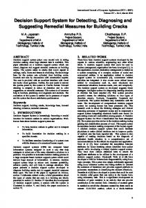
Calexico Mexicali
Ambos Tecate Study Area
Tijuana
TIJUANA T E C A T E Rosarito
M E X I C A L I Pacific Ocean E N S E N A D A Ensenada Tr a n s v e r s e M e r c a t o r P r o j e c t i o n
0
20
40
Gulf of California
Kilometers
Figure 1. Ambos Tecates
Figure 2. Ambos Tecates Home Page
Flood Risk Index (Fri = Hi + Vi)
Vulnerability Index (Vi = Lui)
Hazard Index (Hi = Sli + Sti + Gi)
Slope Index (Sli)
Stream Index (Sti)
Geomorphology Index (Gi)
Figure 3. Hazard Index and Vulnerability Index
Land Use Index (Lui)
Very Low
Flood Risk Index
=
Hazard Index
+
Vulnerability Index
Low Medium High Very High
Figure 4. Application of the Flood Risk Mode