Although typically small in terms of their spatial footprint, landslide hazards are
relatively ... extensive use of GIS, GPS and remote sensing (RS) techniques.
GIS-BASED LANDSLIDE SUSCEPTABILITY MAPPING: A CASE STUDY IN BOSTAN ABAD COUNTY, IRAN Bakhtiar Feizizadeh*a, Thomas Blaschkea, Lubna Rafiq a *
Department Physical Geography, Centre for Remote sensing and GIS, University of Tabriz,Tabriz, Iran a Z_GIS, Centre for Geoinformatics, University of Salzburg, Salzburg, Austria
[email protected]
KEY WORDS: landslide, zoning, spatial analysis, GIS, AHP, susceptibility map, Bostan Abad, Iran
ABSTRACT: Although typically small in terms of their spatial footprint, landslide hazards are relatively frequent in Northern Iran. In this study, we combine GIS and remote sensing and derive a landscape susceptibility map for Bostan Abad County, Iran. The main objective is an inventory evaluation and zonation of natural landslides. This 2685 square kilometer sized county is one of the most important settlement areas in the East Azerbaijan province (North-Western Iran) also containing industrial regions next to the originally predominant agricultural land use. The basic landslides affecting factors are established in form of GIS dataset layers including topography, geology, climatology and land use which is derived from remote sensing imagery. After necessary pre-processing the original data sets a topology is created and active fault lines are buffered and overlaid. Vector layers are transformed into raster format and standardized based on a fuzzy logic model. An Analytical Hierarchical Process is applied in order to derive the weights associated with suitability (attribute) map layers. And based on these weights, GIS datasets are combined by weighted overly techniques and the landslide susceptibility map of the study area created. The resulting information is useful for a) a better understanding of existing landslides and their origins, b) supporting emergency decisions and c) prioritization of efforts for the reduction and mitigation of future landslide hazards.
1. INTRODUCTION Disasters are natural hazard events in which a natural phenomenon or a combination of natural phenomena such as earthquakes, mass movements, floods, volcanic eruptions, tsunamis etc., can cause many loss of lives and damage to the property. Almost no part of the earth’s surface is free from the impact of natural hazards. Though, it may not be feasible to control nature and to stop the progress of natural phenomena but the efforts could be made to avoid disasters and alleviate their effects on human lives, infrastructure and property. It is almost impossible to prevent the occurrence of natural disasters and their damages. However, it is possible to reduce the impact of disasters by adopting suitable disaster mitigation strategies. Among natural disasters landslides are recognized as the third type of natural disaster in terms of world importance (Zillman, 1999). Due to natural conditions or man-made actions, landslides have produced multiple human and economic losses (Schuster and Fleming, 1986; Guzzetti, 2000). Individual slope failures are generally not so spectacular or as costly as earthquakes, major floods, hurricane or some other may cause more damage to properties than any other geological hazards (Varnes, 1987). Most damages and a considerable proportion of the human losses associated with earthquakes and meteorological events are caused by landslides, although these damages are attributed to major events which leads to a substantial underestimation in the available statistical data on landslide impact (Castellanos Abella, 2008). The term "landslide" describes a wide variety of processes that result in the downward and outward movement of slope-forming materials including rock, soil, artificial hill, or a combination of these. The materials may move by falling, toppling, sliding, spreading, or flowing (U.S. Geological Survey, 2004). Landslide can be produced by tectonic factors such as
earthquake or fault, but to do so, there should be a common climate factor such as precipitation on unstable slopes. Climate factors play an important role in making landslide. They can increase or decrease landslides on unstable slopes (Buma and Dehn, 1998). The main objective of this research is to evaluate natural landslide hazards in Bostan Abad County of Iran. This county with 28500 hectares area, is located in the northwest part of Iran and includes two cities and 188 villages with altogether 96.555 inhabitants (Iranian Census Center, 2007). It stretches from about 1559 to 3680 meter above sea level. It is an important area of human habitation, industrial regions and agricultural activities within the East Azerbaijan province. The geophysical location of this region makes it potentially face with some naturally hazardous phenomenon such as landslide, earthquake and volcano activities. Enormous progress has been made in the development of landslide inventories, landscape susceptibility mapping and hazard zoning, whereby much of this progress is based on the extensive use of GIS, GPS and remote sensing (RS) techniques (Cascini 2008, and Westen et al. 2008). While for many years aerial photography was dominantly used satellite remote sensing is more and more regarded as a cost-effective tool for the monitoring of landslides (Metternicht et al. 2005). Our research is based on GIS techniques that are increasingly viewed as a key tool for managing spatial and temporal data for natural hazards (Nathanail, 1998; Kimmance et al, 1999; Parsons and Frost, 2000; Lan et al, 2009, 2005; Kunapo et al, 2005; Forte etal, 2005; Kohler et al, 2006). GIS technology provides effective tools for the handling, integrating and visualizing diverse spatial data sets (Brimicombe, 2003, Lan et al, 2009). Especially GIS Multi Criteria Decision Making (MCDM) are one an important methods of Spatial analysis in GIS that allows knowledge derived from different sources to be
combined in order to support landslide analysis. One multiattribute technique that has been incorporated into the GISbased landslide analysis procedures is the Analytical Hierarchy Process that presented by Saaty (1980). In this study, AHP is employed to derive the weights to weighted overly layers. The weights are then combined with the attribute map layers in a manner similar to that used in the linear additive combination methods (Malczewski, 2004).
Table 1, Evaluation criteria for landslide susceptability map Topography Human factors Geology
Slope Aspect landuse Roads lithology Faults
2.
MATERIAL AND METHODOLOGY
Rivers Climate
Landslide susceptibility is predominantly a function of slope and combinations of slope, concavity/convexity and aspect Next to these topography factors , geology, geotechnical properties, climate, vegetation and anthropogenic factors such as development and clearing of vegetation (Fell et al, 2008) are other important factors. In this study landslide susceptibility was evaluated by applying different analytical GIS techniques including, Overlaying, Buffering, and Network analyzing based on multi criteria analysis and Analytical Hierarchical Process (AHP). For this to happen, the following factors affecting landslides were established:For Hazards assessment
Lithology map derived from geological maps 1:100,000 Fault distance map from both geology map and SPOT 5satellite images Transportation network extracted from topography maps 1:25000 and updated with the help of satellite images. Hydrological networks map extracted from topography maps 1:25000 Digital topographic maps 1:25000 and hypsometric map as well as a DEM1with slope, aspect and other slope derivates. Land use and land cover maps derived from SPOT 5 satellite images Meteorological data including rainfall for a 30 year period and precipitation maps created from the rainfall data These data were pre-processed and added to a Geo-database. The spatial data layers listed above were prepared. In the next step, active fault lines were buffered and vector layers were transformed into raster format through overlay techniques while being standardized based on fuzzy logic models. Then, a Analytical Hierarchical Process was applied to extract standardized weights for the different layers. Finally, the landslide susceptibility maps of the study area were created by weighted overlaying techniques as described in the next subsection. 2.1 Selection of evaluation criteria and Standardization The set of criteria selected should adequately represent the decision-making environment and contribute towards the final goal (Prakash 2003). The evaluation criteria listed in Table 1 were selected in order to considered to address the objective of mapping landslide susceptability. Various preprocessing steps were carried out for the spatial data layers listed in Table 1 and a topological geo-spatial database constructed. Vector layers were converted into raster format with 20 m resolution and the spatial datasets were processed in ArcGIS. Slope and aspect were generated from a 20 m resolution DEM which was derived from the 1:25000 topographical maps. our methodology is based on A pairwise comparison technique based on AHP.
1
Digital Elevation Model
Precipitation
2.2 Land use and land cover classification Satellite imagery has been effectively utilized in classification process, especially; in generating land use/ cover (LULC) maps and detecting land cover conditions (Lobo et.al 2004; Cohen et.al, 2004; Musaoglu et.al 2005). In this study, we produced a LULC classification of the study area as input to the landslide analysis. For this purpose we used two scenes of SPOT 5 images of 15 May 2010 for a supervised classification. After Geo-referencing and atmospheric correction, the images were classified using a Maximum likelihood classification (MLC) algorithm in a perpixel classification approach. Five land use/cover types were identified, including (i) settlement area (ii) agricultural area (iii) pasture lands (iv) water bodies and (v) rock and bare soils. To evaluate the accuracy of the classified image, the “Accuracy Assessment” tool in Envi was used based on random sampling method whereby 120 points were selected from high resolution aerial photos and Google Earth maps. The overall accuracy and the Kappa Coefficient were calculated and result in an overall accuracy of 90.2% and a Kappa Index of 0.88. In a consecutive stage the classification was exported to the GIS as one dataset layer for the landslide analysis. 2.3 Assessing the weights and overlaying map layers Deriving weights for the selected map criteria is a fundamental requirement for applying the Fuzzy AHP method (Malczewski 1999). Determination of the particular criterion weight is therefore a crucial step in MCDM. The AHP is considered to be an adequate mathematical method for this step when analyzing complex decision problems (Saaty 1977, 1980). GIS-based AHP has gained popularity because of its capacity to integrate a large quantity of heterogeneous data, and because obtaining the required weights can be relatively straightforward, even for a large number of criteria. It has been applied to a variety of decision making problems (Tiwari et al, 1999; Nekhay et al, 2008; Hossain and Das, 2009). In this research we used standard weights obtained from the AHP. One of the strengths of AHP is that it allows for inconsistent relationships while, at the same time, providing a consistency ratio (CR) as an indicator of the degree of consistency or inconsistency (Forman and Selly 2001). The AHP implementation in this study therefore incorporated an option to let the user define an acceptable CR threshold value. If the CR is greater than 0.10, it is important to be careful to accept the resulting weights without changing the inputs to the pairwise comparison matrix, and also to feel confident that the matrix really reflects the user’s beliefs and does not contain any errors (Bodin and Gass 2003; Chen et al. 2009). The resulting pairwise comparison matrix for landslide analysis in Boston Abad county is shown in Table
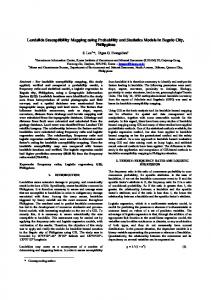
2. The resulting CR for the pairwise comparison matrix was equal 0.064. In the next step, the map layers used in the landslide analysis were weighted using the weights derived from through the AHP process. and the final result are shown in figure (1).
Table 2. Pairwise comparison matrix for landslide analysis Factors
1
(1) Distance to stream (2) Distance to road (3) Aspect (4) Slope (5) lithology (6) Distance to fault (7) Precipitation (8) Land use
1 1 1/3 6 8 1/2 7 7
2
3
4
5
1 1/3 1 5 7 1 7 9 4 1 3 5 1/3 1/4 6 8 3 1/2 6 8 3 1/2 Consistency ratio: 0.064
6
1 4 4
7
4 4
Figure1: landslide susceptibility map of Bostan Abad County
8
1
Eigen Values 0.045 0.036 0.020 0.122 0.300 0.063 0.207 0.207
3. RESULTS AND DISCUSSIONS In this study, the analytical hierarchy process (AHP) was applied to develop landslide susceptibility map for the Bostan Abad County. To achieve this objective, Eight landslide inducing factors were calculated, namely aspect, slope, distance from streams, lithology, distance from roads, distance to fault, precipitation and land use/land cover (LULC). These factors were evaluated, and then factor weight and class weight were assigned to each of the associated factors. The obtained susceptibility map indicate that the high susceptible zones cover about 20.4% (53703.9 hectare) of the total area while about 67.20 % (180447.16 hectare) were classified as being the moderately susceptible and 12.39 % of the case study area (33272 hectare) are classified as low susceptible. The map was verified using existing landslide location data for the area, particularly agriculture activities and critical human settlements such as Bostan Abad city. It turned out that highly susceptible zones cover most of the known landslides that occurred in the unstable slopes over the last several years and which were predominantly induced by high precipitation. It is known that the role of precipitation as triggering mechanisms of landslides is strongly influenced by the landscape dynamic and geology. In Bostan Abad County landscapes are common, and rainfall and snowmelt (especially snow melting of the Sahand glacier) often bear the potential for initiating slope Instabilstes. Susceptible stratigraphy and weathering too, contribute much for the occurrence of landslides in this area. With conditions conducive to the development of slope instability being in place in several areas, there was a demand to conduct landslide susceptibility mapping. Results of this research could be useful for explaining the known existing landslide, making emergency decisions and supporting the efforts of reduction and mitigation of future landslide hazards. The hazard and risk maps have usually incorporated the estimated frequency of landsliding in a qualitative sense rather than quantitatively. Landslide hazard zoning has already been used to manage landslide hazard risk in urban areas by excluding development in highly susceptible areas, whereas geotechnical engineering assessment of slope stability necessitates more detailed on-site exploration. before development is approved in other areas. Fine-scale GIS-based susceptibility maps derived in this study can bridge the gap between overview plans and regional zoning one the one side and the cost-intensive on-site investigations for engineering tasks on the other side.
References from Journals: Bodin, L., Gass, S., 2003, on teaching the analytic hierarchy process. Computer & Operations Research, 30, pp1487-1497. Buma, J., Dehn, M., 1998, A method for predicting the impact of climate change on slope stability. Environ. Geol. 35, pp. 190–196 Cohen, W.B., Goward, S.N., 2004, Landsat’s role in ecological applications of remote sensing. Bioscience 2004, 54,pp 535-545. Collins, M.G., Steiner, F.R., and Rushman, M.J., 2001, Landuse suitability analysis in the United States. historical development and promising technological achievements. Environmental Management, 28(5),pp 611–621.
Fell.R, Corominas.J, Bonnard.C, Cascini.L, Leroi.E and Z.Savage.W., 2008, Guidelines for landslide susceptibility, hazard and risk zoning for land-use planning, Engineering Geology 102 (2008)pp 99–111. Kohler, P., M¨ uller, M., Sanders, M., and W¨ achter, J., 2006, Data manage-ment and GIS in the Center for Disaster Management and RiskReduction Technology (CEDIM): from integrated spatial data tothe mapping of risk, Nat. Hazards Earth Syst. Sci., 6, pp 621–628. Kimmance, J. P., Bradshaw, M. P., and Seetoh, H.,1999, Geographical Information System (GIS) Application to Construction andGeotechnical Data Management on MRT Construction Projectsin Singapore, Tunnelling Underground Space Tech., 14(4), 469– pp 479, 1999. Kunapo, J., Dasari, G. R., Phoon, K. K., and Tan, T. S., 2005, Development of aWeb-GIS based geotechnical information system, J. Comput.Civ. Eng., 19(3), pp 323–327. Guzzetti. F., 2000, Landslide fatalities and the evaluation of landslide risk in Italy.SlopEngineering Geology, 58(2): pp 89-170. Hossain, M.S., and Das, N.G., 2009, GIS-based multi-criteria evaluation to land suitability modelling for giant prawn (Macrobrachium rosenbergii) farming in Companigonj Upazila of Noakhali, Bangladesh. Computers and Electronics in Agriculture, 70(1). Lobo, A., Legendre, P., Rebollar, J.L.G., Carreras, J., Ninot, J.M., 2004, Land cover classification at a regional scale in Iberia: Separability in a multi-temporal and multi-spectral data set of satellite images. International Journal of Remote Sensing 25(1), pp 205-213. Lan, H.X, Martin., C.D, Froese, C.R, Kim, T.H, Morgand Chowdhury S., 2009, A web-based GIS for managing and assessing landslide data for thetown of Peace River, Canada, Nat. Hazards Earth Syst. Sci., 9,pp 1433–1443. Lan, H. X., Zhou, C. H., Wang, L. J., Zhang, H. Y., and Li, R. H., 2004, Landslide hazard spatial analysis and prediction using GISin the Xiaojiang watershed, Yunnan, China. Eng. Geol., 76(1–2), pp109–128. Musaoglu, N.,Coskun, M., Kocabas, V., 2005, Land use change analysis of Beykoz- Istanbul by means of satellite images and GIS. Water Science and Technology, 51, 245251. Malczewski, J., 2004, GIS-based land-use suitability analysis: a critical overview. Progress in Planning, 62(1), pp 3-65. Metternicht, G., Hurni, L., Gogu, R., 2005, Remote sensing of landslides: an analysis of the potential contribution to geospatial systems for hazard assessment in mountainous environments. Remote Sensing of Environment 98 (23), pp 284–303. Nathanail, C. P. and Rosenbaum, M. S., 1998, Spatial management of geotechnical data for site selection, Eng. Geol., 50(3–4), pp 347–356. Nekhay, O., Arriaza, M., and Guzmán-Álvarez, J.R., 2008,Spatial analysis of the suitability of olive plantations for
wildlife habitat restoration. Computers and Electronics in Agriculture,pp 65, 49-64. Saaty, T.L., 1977, A scaling method for priorities in hierarchical structures. Journal of Mathematical Psychology, 15, pp 231-281 Schuster, R.L.and Fleming, W.F., 1986, Economic losses and fatalities due to landslide. Bulletin of the Association of Engineering Geologist, XXIII (1), pp11-28. Parsons, R. L. and Frost, J. D.,2000, Interactive analysis of spatial sub-surface data using GIS-Based tool, J. Comput. Civ. Eng., 14(4), pp 215–222 Tiwari, D.N., Loof, R., and Paudyal, G.N, 1999, Environmental-economic decision-making in lowland irrigated agriculture using multi-criteria analysis techniques. Agricultural Systems, 60, pp 99-112. van Westen, C.J., Castellanos Abella, E.A. and Sekhar, L.K.,2008, Spatial data for landslide susceptibility, hazards and vulnerability assessment : an overview. In: Engineering geology, 10(3-4) pp 112-131. Varanes, D.J.,1987, Slope monement types and processes. National Academy of Scinces, Washington, D.D., pp.11-33. Zillman.J., 1999,The physical impact of disaster.In.J.Ingleton (Editor), Natural disaster management. Tudor Rose Holding Ltd., Leicester, PP 320 References from Other Literature: Brimicombe, A., 2003, GIS, environmental modelling and engineering, London, New York, Taylor & Francis, p 312 Chen, Y., Khan, S., and Paydar, Z., 2009, To retire or expand, A fuzzy GIS-based spatial multi-criteria evaluation framework for irrigated agriculture. Irrigation and Drainage. doi:10.1002/ird.470 (Published online). Castellanos Abella.E.A., 2008, multei-Scale landslide risk assessment in Cuba, PhD thesis, ITC, ITC.Nl Forte, F., Pennetta, L., and Strobl, R. O., 2005, Historic records and GIS applications for flood risk analysis in the Salento peninsula (southern Italy), Nat. Hazards Earth Syst. Sci., 5, 833–844, 2005,http://www.nat-hazards-earth-systsci.net/5/833 Forman, E.H. and Selly, M.A., 2001, Decision by Objective e How to Convince Others That You are Right. World Scientific Publishing Co. Pte. Ltd, Singapore Iranian Census Center., 2007, Iranian cities population. http://www.amar.org.ir Malczewski, J,. 1999, GIS and Multicriteria Decision Analysis (Wiley, Toronto). Prakash, T.N., 2003, Land Suitability Analysis for Agricultural Crops: A Fuzzy Multicriteria Decision Making Approach. MSc thesis in ITC http://www.ITC.com.