2013 Fifth International Conference on Geo-Information Technologies for Natural Disaster Management
IDENTIFYING EFFECTING FACTORS AND LANDSLIDE MAPPING OF CAMERON HIGHLAND MALAYSIA Somayeh Mollaee 1, Saied P irasteh2 *,Mohammad Firuz Ramli1 , Syed M.A.Rizvi3 1. Department of Environmental Studies, Universiti Putra Malaysia 2. Department of Geography and Environmental Management, University of Waterloo, Canada 3. Remote sensing and GIS, Department of Geology, Aligarh Muslim University, India
[email protected]
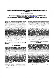
Abstract The combination of the tectonic processes and the impacts on the environment can be seen in the form of landslides. Structural features such as faults, lineaments and folds play a major role in controlling landslides. This may help to evaluate more accurate landslide mapping. The phenomena of landslides from diverse origins are very frequent in Malaysia and mainly in the region which the bed rocks are clays, sandy limestone, and marls. Due to the susceptibility of the population, the economy and the infrastructure, it is necessary to identify locations and develop landslides maps. This study tries to express identified factors effecting landslides based on the previous works. In addition, it tries to interpret and discuss on behavior of landslide occurrence of the Cameron Highland. However, this study presents an emphasis on potential areas for landslides mapping with considering lineaments as one of the effecting for probability occurrence of landslides. Also, the usefulness of GIS technologies has made us enable to develop various maps of effecting factors. This study has identified the localization of landslides for susceptibility mapping. Keyword: Landslide; Susceptibility; Lineament; Cameron Highland Background and Introduction Large efforts have been made to investigate the causes and mechanisms of landslides using accurate monitoring techniques [1][2][3][4][5][10][12]. It is notable that the Asia itself, as the most hazardous and vulnerable continent, has been suffering more than 50 per cent of events, 90 per cent of casualties and 49 per cent of the losses of natural disasters in the globe, leading to an average rate of 41 thousand tolls and 29 billion dollars loss a year. The maximum economical casualties caused by natural disaster within 1900 to 2005 occurred in Asia Pacific [15]. In Malaysia,urban development, without adequate technical guidance, contributes to the fact that the safety factor of natural slopes is diminishing, creating problems of instability. Recently natural hazards and mass movements like landslides and debris flows result lots of property damage and human losses in mountainous regions. Landslides are a serious geological hazard common in most countries of the world (Figure 1). A large amount of research on landslide hazard zonation has been done over the last 30 years as the consequence of an urgent demand for slope instability hazard mapping. Overviews of the various slope instability hazard zonation techniques can be found in [2][3][6][11]. Landslides are defined variously by different experts, the underlying facts however is how they occur. This is captured in [1][7][8] definition as “the movement of a mass of rock, debris or earth down a slope”. Tables 1 and Figure 1 show the world statistics of landslides 1993 to 2008. It evident that the Asian and American continents have the most occurrences, with Asia alone accounting for almost half of the world’s events. Considering the population density in Asia, it also shows the most impact to live and property (Table 1). 978-1-4799-2269-7/13 $26.00 © 2013 IEEE DOI 10.1109/GIT4NDM.2013.11
73
Figure 1: World Landslide 1903-2007 Source for data [15] Table 1: World statistics for landslides. Source for data [15] Injured Homeless affected Total affected
Countries
Events
killed
Asia
255
18,299
3,778
3,825,311
1,644,683
5,476,770
Damage (000,s) 1,534,893
Africa
23
745
56
7,936
13,748
21,740
No data
Americas
145
20,684
4,809
186,752
4,485,037
4,676,598
1,226,927
Europe
72
16,758
523
8,625
39,376
48,524
2,487,389
Oceania
16
542
52
18,000
2,963
21,015
2,466
Total
511
57,528
0,216
4,046,624
6,188,807
10,244,647
5,251,675
US
Guzzetti, et al. [13] extracted geology, topography and landuse parameters (Table 2) such as morphological, lithological, and structural from aerial photographs taken between 1955 and 1999. The study area was partitioned into 2243 geo-morpho-hydrological units in a probabilistic model to find out landslide hazard in the Staffora River basin, in the northern Apennines, Italy. Their model was modulated to determine landslide hazard based on the assumptions of Varnes and the IAEG (1984) Commission on Landslides and other Mass-movements [14]. It also resulted in the generation of many different hazard maps.
74
Table 2: Fundamental Parameters Controlling the Landslides Occurrences [14]
Rainfall Heavy
Clay Sediment Layers
Earthquake Event
Water saturation
Slopes Ranging (30 o-60o)
infiltration of soil
Lithology
Human actions
Stratalogy
Landuse
Sediment Discharge
Geomorphology
The phenomena of mass movement from diverse origins are very frequent in Malaysia and mainly in the region which the bed rocks are clays, sandy limestone, and marls [4]. In December 2009 a major landslide even occurred in Bukit Antarabangsa in Kuala Lumpur [16]. Its disruptive effects impacted on lives and property to the tune of millions. Due to the susceptibility of the population, the economy and the infrastructure, it is necessary to identify, evaluate and map them. Landslides are one of the most destructive natural disasters in Malaysia. From 1993 to 2006 around 20 major landslides were reported in Malaysia. Historically, the country had faced several tragedies. The chronology is given as follows: Dec 4, 2008: Some 300 people were evacuated while six cars were buried in a landslide which occurred at about 5.20pm at Jalan Semantan, Kuala Lumpur. Five vehicles were damaged. Nov 30, 2008: Two sisters Noratirah Roslan, 16, and Nurul Intan Sarina, 9, were buried alive when the hill at the back of their house in Jalan Belida 1, Ulu Yam Perdana collapsed at 5.30am. Oct 22, 2008 Over eight cars were destroyed after a landslide hit a car park at Paya Terubong, George Town at 3am. Oct 17, 2008 Two Indonesian workers were killed in a landslide which occurred at 10am at a quarry in Kajang. Aug 4, 2008: Eight families were relocated following a landslide which struck the Sungai Kerpan 3 low-cost housing project in Kuala Lipis. However, this study expresses identifying landslides locations in enhancing susceptibility mapping in Cameron Highland, Malaysia for future researches. In this study the effecting factors such as topography, lithology, vegetation, lineament, slope and soil have been mapped in GIS environment and further interpret the probablity of landslide occurance in the area. In addition, lineaments are extracted from Spot satellite image using key elements such as tone, shape, erosion and topography. Study Area and Methodology The study area (Figure 2) is bounded by 372000N to 384000 N and Longitudes 516500 E to 534000 E. It is undulating terrain and the topography is generally between 160 m to 2,109 m above the mean sea level. The temperature is around 16°C to 26°C, with an average rainfall of about 2,000 mm [5]. The study area falls in Cameron Highland district, Pahang (Figure 2).
75
Figure 2. Study area The trend of Malaysia’s mountainous is North-south. In fact it is an intercratonique geological zone that is formed by two platforms under posses hydro statiques) [5] (Figure 3). It is in all probability that landslides are occurred when failure slopes are charged and influenced by tectonic activities and rainfall and human actions.
Figure 3. The trend of Malaysia’s mountainous The geology of Cameron Highland consists of acid intrusive bodies, volcanics and metamorphic rocks including schist, phyllite, slate and in some sedimentary rocks such as limestone and sandstone are common visible rocks The lithology map of the study area is hown in Figure 4. The Spot satellite image, lithological map from Mineral and Geoscience Department, previous landslides location, digital elevation model (DEM) interpolated in order to analyse the data and process generating maps.
76
Figure 4. Lithology map of Cameron Highland, Malaysia
Figure 5 . Showing landshlide locations on lithology The existing lithology data were introduced to ARCGIS in order to show landslides on lithology map of the region (Figure 5). Soil data were introduced to GIS environment and using tools in ARCGIS a soil map is produced (Figure 6a). Further landslides are oveliad on soil map to express the role of soil as an an effecting factor in landslide occurance (Figure 6b). Lineament mapping has been attempted through remotely sensed data which is processing and visualize in a GIS environment and considered one of the factors effecting landslides.
77
Figure 6. a) Soil map, b) landslides on soil map of Cameron Highland, Malaysia One of the effecting factors on landslides is lineaments. In order to extract the lineament from the Spot satellite image, ENVI software has been used. Digital image processing for enhancing the lineaments on the image has been carried out using linear 2% technique. The visual digital digitization was done on the image and for each lineament a line was drawn (Figure 7). The key elements for extracting lineaments were tone, shape, topography and linearity of vegetation. Further to express the role of the lineaments on occurring probability potential of landslide in the region, landslide locations were overlaid on lineament map (Figure 7).
Figure 7. Lineament overlaid on landslide map of Cameron Highland In order to interpret the probability of the role for each effecting factor a lineament density map has been prepared and overlaid on landslide location map using ARCGIS analysis tools (Figure 8)
78
Figure 8. Lineament density map overlaid on landslide location layer A field check has been carried out and practically experiences the effective parameters on landslides (Figure 9). These confidents are useful to verify the analysis and results from this study and increase the evidences for probability expression of landslide occurrences in the area.
Figure 9. Showing a landslide due to heavy rain and washed vegetations Digital elevation model (DEM) is one of the main factors effecting landslides in Cameron Highland. The topography data was introduced to ARCGIS and using 3D tools, DEM has been created (Figure 10a). Further, to generate slope map of the area the spatial analysis tool in ARCGIS enable us to develop slope map with 100meter in grid size (Figure 10b)
79
Figure 10. a) DEM of Cameron Highland, b) slope map The area is covered by high density of vegetation which is another involving factor of occurrence of landslide. Normalize Differentiate Vegetation Index (NDVI) was digitally carried out in ENVI software to produce the NDVI map (Figure 11).
Figure 11. NDVI map of the area Results and Discussion With respect to the previous studies by several researchers [1][2][3][5]7][8][9][11][12][13]; 6 failures factors (i.e. DEM slope, vegetation, lithology, lineament and soil) have been studied and identified that are contributing landslide occurrence. This enables to interpret the probability of the potential landslides occurrence in Cameron Highland. However, note that there are other factors involving landslide occurrence which here we have not brought into consideration because of not accessibility of data. They are such as rain fall, humidity, drainage networks and density of vegetation. This paper has contributed identifying lineaments from the Spot image using ENVI software. The density lineament map (Figure 12) shows that in some part of the area the probability of landslide occurrence are high due to high density of lineament with respect to other involving factors such as soil, slope and lithology. We have found that some of the lineaments are exactly on the range of the suspected landslide areas and there is a probability expression on landslide occurrence. This probably reveals that lineaments have produced increment
80
potential to landslides while in other area other factors such as slope and vegetation are controlling the landslide s occurrence.
Figure 12. Showing landslides on lineament and lithology map Visual interpretation on the developed soil and lithology maps suspects that most of the landslides may occur in asid intrusive bodies rather than schist and other rock type. Based on the previous studies we have seen more than 200 landslides in the study area. The vegetation map shows that it has played a major role on controlling landslides and it can be depicted from Figure 11 and 13. In addition, we probably can say the high density of vegetation, the fewer landslides with respect to the other controlling parameters. The landslide areas vary and the based on Geographic Information System (GIS) analysis using X-tools extension in ARCGIS the following information are produced for existing landslides. Sum: 15680.434 Count: 368 Mean: 42.610 Maximum: 15622.726 Minimum: 0.000 Range: 15622.726 Variance: 663219.178 Standard Deviation: 814.383. However, during this study and a felid check we realized that there might be more potential for landslides though some of the locations have already been prepared for any future hazards. This can make suspect on future natural hazards. In addition, this can build up an idea for the future study for developing a more accurate susceptibility map of the area. This study shows the usefulness of GIS in landslide mapping. Conclusion and Recommendation Cameron Highland areas are prone to landslides. The factors such as soil, vegetation, topography, slope, lithology and lineament have been counted into consideration. They are influencing increment potential of the landslide occurrences in the area. However, landslide-location and potential areas for susceptible mapping can be assessed further in future studies and predicted through scientific analysis of landslides. In addition, we suggest landslide related factors to be assessed and geographic information system (GIS) software, Arc GIS 9.2 to be used as the basic analysis tools for spatial management and data manipulation. Further density landslide map (Figure 13) of the area has also been developed using ARCGIS analysis tools in order to suggest the effect of the possible landslide on networking transportation for future studies.
81
Figure 13. Showing density landslide map Acknowledgement This study has been extracted from a small project which is a part of Master program in Environmental studies. I appreciate my supervisor for his guidance. The data was provided by Universiti Putra Malaysia for the project work and thanks to Universiti Putra Malaysia. References 1. Alireza Farrokhnia, Saied Pirasteh, Biswajeet Pradhan, Mohamad Pourkermani , Mehrdad Arian , 2011, A recent scenario of mass wasting and its impact on the transportation in Alborz Mountains, Iran: Contribution from Geo information technology, Arabian Geosciences Journal, 4: 1337-1349 DOI 10.1007/s12517-010-0238-7 2. Biswajeet Pradhan, Saied Pirasteh, 2010, Comparison between prediction capabilities of neural network and fuzzy logic techniques for landslide susceptibility mapping, Disaster Advances Journal, Volume 3, Number 3, Page 19-25 3. Saied Pirasteh, Biswajeet Pradhan, Amir Mahmoodzadeh, 2009, Stability Mapping and Landslide Recognition in Zagros Mountain South West Iran: A Case Study, Disaster Advances Journal, Volume 2(1), Page 47-53 4. N.Yusof, M.F.Ramli, S.Pirasteh, H.Z.M.Shafri, 2011, Landslides and lineaments mapping along the Simpang Pulai to Kg Raja highway, Malaysia, International Journal of Remote Sensing IJRS, Volume 32 Issue 14, July 2011 5. Mohamad Abd Manap, Mohammad Firuz Ramli, Wan Nor Azmin Sulaiman & Noraini Surip, 2010, Application of Remote Sensing in the Identification of the Geological Terrain Features in Cameron Highlands, Malaysia, Sains Malaysiana 39(1) 6. Dai, F.C. & Lee, C.F. 2002. Landslide characteristics and slope instability modelling using GIS, Lantau island, Hong Kong. Geomorphology 42(2002): 213-228 7. Davis, A.M. & Mason, P.J. 2000. Three dimensional of landslide in SE Spain using a digital elevation model (DEM) and orthophotography. Landslides in research, theory and practice, Thomas Telford (ed.). London 403-408 8. YILMAZ, I. and YILDIRIM, M., 2006, Structural and geomorphological aspects for the Kat Landslides (Tokat Turkey) and susceptibility mapping by means of GIS. Environmental Geology, 50, pp. 461-472. 9. SARKAR, S. and KANUNGO, D.P., 2004, An Integrated Approach for Landslide Susceptibility Mapping Using Remote Sensing and GIS. Photogrammetric Engineering & Remote Sensing, 70, pp. 617–625. 10. Ramli, M.F., Tripathi, N.K., Yusof, N., Shafri, H.Z.M. And Ali Rahman, Z., In Press, Lineament mapping in tropical environment utilising Landsat imagery International Journal of Remote Sensing.
82
11. Pradhan, B., Singh, R.P., And Buchroithner, M.F., 2006, Estimation of stress and its use in evaluation of landslide prone regions using remote sensing data. Advances in Space Research, 37, pp. 698-709. 12. Al-Mokredi, M.S., Guangdao, H. And Bassam, B.F. A., 2007, Using Remote Sensing Data to Delineate the Lineaments for Hydrothermal Mineral Prediction in Heqing Area, Northwest Yunnan Province, China. Journal of China University of Geosciences, 18, pp. 142-147. 13. Guzzetti, F., P. Reichenbach, M. Cardinali, M. Galli, and F. Ardizzone, 2005 . "Probabilistic landslide hazard assessment at the basin scale", Geomorphology 72, pp. 272– 299. 14. Guzzetti, F., A. Carrara, M. Cardinali, and P. Reichenbach, 1999 . "Landslide hazard evaluation: a review of current techniques and their application in a multi-scale study, Central Italy", Geomorphology 31, pp. 181–216. 15. www.unescap.org 16.http://www.dailymail.co.uk/news/article-1092418/Massive-landslide-outskirts-Kuala-Lumpur-kills-people.html
83