{kawaji, hatada, yamasaki, aizawa}@hal.t.u-tokyo.ac.jp. ABSTRACT ..... [6] R. Want, A. Hopper, V. Falcao, and J. Gibbons, âThe active badge location systemâ ...
Image-based Indoor Positioning System: Fast Image Matching using Omnidirectional Panoramic Images Hisato Kawaji† , Koki Hatada† , Toshihiko Yamasaki† , Kiyoharu Aizawa‡ ,† †Graduate School of Information Science and Technology, ‡Interfaculty Initiative in Information Studies The University of Tokyo, Tokyo, Japan
{kawaji, hatada, yamasaki, aizawa}@hal.t.u-tokyo.ac.jp ABSTRACT
Table 1 Existing technologies performance [13]
In this paper, we developed an image-based indoor localization system using omnidirectional panoramic images to which location information is added. By the combination of the robust image matching by PCA-SIFT and fast nearest neighbor search algorithm based on Locality Sensitive Hashing (LSH), our system can estimate users’ positions with high accuracy and in a short time. To improve the precision, we introduced the “confidence” of the image matching results. We conducted experiments at the Railway Museum and we obtained 426 omnidirectional panoramic reference images and 1067 supplemental images for image matching. Experimental results using 126 test images demonstrated that the location detection accuracy is above 90% with about 2.2s of processing time.
Technology
Positioning accuracy
Equipment cost
User burden
Infrared light
5-10m
High
Middle
Ultrasonic
1-10cm
High
Middle
RFID
5cm-5m
High
Middle
Wi-Fi
2-100m
High
High
Audible sound
5-10m
Middle
Low
Mobile camera
1-5m
Low
Middle
Monitor camera
1cm-1m
High
Low
In this point of view, some indoor positioning systems have been proposed using infrared light [6], ultrasonic [7], Wi-Fi [8], Active-RFID [9] and image processing [10], and so forth. We can also find some iPhone-based smart museum guidance systems using Wi-Fi [11,12]. As can be seen in the references, indoor localization in museums is highly demanded. If the users’ locations can be obtained, more interactive guidance (such as personalized explanation of display, route recommendation, and sharing viewers’ experiences in museum) and more accurate user behavior analysis to improve the display configuration would become possible. For this purpose, we need to meet some requirements: (1) environmentally-sound development, (2) as low user burden as possible, (3) fast and high precision localization adapting to wide area and handling multiuser. In terms of (1), it is very hard to implant devices such as sensors in museums because of preserving the museums’ appearance. Furthermore, when we implement equipments, we must consider their costs, operations, and maintenance. In (2), the viewers should enjoy traveling in museums without the wearable devices get in the way of viewing. Table 1 [13] shows the comparison of existing indoor positioning technologies about positioning accuracy, equipment costs, and user burden. Considering these requirements, image processing is suitable for indoor positioning in museums. Therefore, in this paper, we employ an image-based approach using digital cameras or cell phone cameras to meet the requirements.
Categories and Subject Descriptors H.5.1 [Multimedia Information Systems]; H.4.0 [Information Systems Applications]
General Terms Algorithms
Keywords Indoor localization, omnidirecitonal camera, tag, locality sensitive hashing (LSH), PCA-SIFT
1. INTRODUCTION In recent years, location-aware services [1,2] such as restaurant recommendation and track-log-based processing [3,4] such as summarization and retrieval, travel route recommendation, and so on have been drawing a lot of attention because of the advantages of semiconductor devices. For instance, GPS receivers are already contained in most of the cell phones and PDAs. Although outdoor positioning systems are easy to implement by using GPS, Wi-Fi [5], and radiowave strength from base stations, that for indoor environment is still a difficult problem because GPS signals cannot be received and multipath fading occurs severely limiting the precition of the location estimation.
The image-based positioning system was firstly proposed by Aoki et al. [10]. They used a wearable camera and a laptop computer for capturing images and hue histgram for image features. Then, SURF and SIFT based image matching system was developed [14,15] for more accurate location estimation However, these method took a lot of time (several hundred seconds for each image) and were not feasible for real-time applications. The contribution of this paper is two-fold. First, an entire system for indoor positioning system has been developed: quick database
Permission to make digital or hard copies of all or part of this work for personal or classroom use is granted without fee provided that copies are not made or distributed for profit or commercial advantage and that copies bear this notice and the full citation on the first page. To copy otherwise, or republish, to post on servers or to redistribute to lists, requires prior specific permission and/or a fee. MPVA’10, October 29, 2010, Firenze, Italy. Copyright 2010 ACM 978-1-4503-0167-1/10/10…$10.00.
1
Omnidirectionl images
Supplemental images
Query
Feature extracting Feature filtering
Feature extracting
Hash calculating of LSH
LSH hash searching
Image map DB
pre-established
Error filtering Calculate “Confidence” Location estimation
Omnidirectional camera
Figure 3 Annotation interface The location information is attached to all the images by using our interface demonstrated in Figure 3. The annotation data include the (x,y,z) coordinates of the images on the map, exhibition name, room name, the floor, and showcase name for supplemental image.
Tripod stand
2.3 Image matching
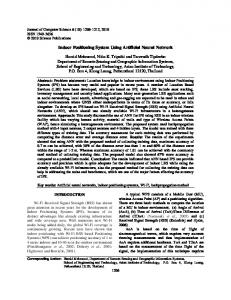
Figure 1 Our system overview
Our system uses PCA-SIFT features [18] and fast nearest neighbor search based on LSH [16] for image matching. After that, our system removes the error in the correspondent points by RANSAC [19]. Since there are many reference images, it is necessary to search correspondent point of the images with high speed.
Laptop Battery Wheeled platform
2.3.1 PCA-SIFT
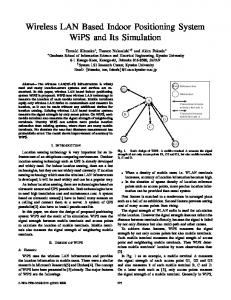
Figure 2 Omnidirectional-image capturing system
PCA-SIFT is a SIFT-improved local feature. After 128 dimensional feature vectors based on image gradients are extracted by SIFT, they are compressed to 36 dimensions by principal component analysis (PCA) and canculated features. Same as SIFT, PCA-SIFT features have a robustness to affine transformation even with scaling and rotation. By compressing dimensions, noises in gradient and correlation are reduced. Therefore, PCA-SIFT is known as high-descriptive feature.
construction using an omnidirectional camera, image matching system, and visualization interface. Second, the image matching has been made fast by using Locality Sensitive Hashing (LSH) [16] and more accurate by introducing a “confidence” parameter in the matching. we obtained 426 omnidirectional panoramic images and 1067 supplmental images in the Railway Museum. In addition, we conducted image matching experiment using abovedescribed images as references and improved the precision of image matching from 86% to 91% with low additional computation costs.
2.3.2 Locality Sensitive Hashing (LSH) Because the number of images in the database is quite large and at the same time quick response is critical in same applicatons, efficient nearest-neighbor image search is very important. There are some fast nearest neighbor search algorithms such as LSH and ANN [17].
2. OUR PROPOSED SYSTEM 2.1 Flow chart
LSH is a probabilistic nearest neighbor search method using hash functions. In case of 20 or more dimensional vectors, it is reported that LSH is faster than the other algorithms. In particular, E2LSH [16] is employed in our system because we want to calculate Euclidean distance based similarity. After searching the correspondent points by LSH, the outliers (erroneous correspondent points) owe removed by RANSAC [19].
The flow chart of our proposed system is shown in Figure 1. The omnidirectional images and supplemental images are taken and features are extracted in the server in advance. In addition, we add annotation such as location and orientation of the image. Then, we construct an “image map” database. When a user takes a picture, it is sent to the server and feature extraction and image matching with the database are conducted. For the image matching, PCA-SIFT in conjunction with LSH-based similarity measure is used as explained in 2.3.
2.3.3 The confidence measure In order to improve the image matching performance, we developed a confidence measure under the assumption that users tend to take their focus of attention closer to the center of the image. Namely, we calculate the confidence measure considering the location of the correspondent point in the image:
2.2 Image map The image map is the dataset of images, image features, and annotations. The omnidirectional images of the museum are taken using the system shown in Figure 2. The omnidirectional camera is set on a tripod stand on a wheeled platform and the images are captured with the laptop computer under the stand. The system is portable and it is easy to cover a wide area. The supplemental images are those cannot be captured by the omnidirectional camera such as inside the showcases and they are taken by digital cameras.
Wk = e −( xk
2
2
+ yk 2 ) 2σ 2
K
, C = ∑Wk k =1
(a)
(c)
Table 2 Precision and processing time of image matching using each feature Feature
Feature extraction
Correspondent point search
Total
Precision
SIFT
1.51s
1.60s
3.11s
91.9%
PCA-SIFT
1.63s
0.56s
2.19s
90.8%
SURF
0.22s
1.54s
1.77s
88.2%
Table 3 Precision rate
Precision
(b)
Without confidence measure
With confidence measure
86.1%
91.1%
Table 4 Processing time
Figure 4 Our interface visualizing the results 155.2m
47.6m
Processing time
Without confidence measure
With confidence measure
4.43s
4.52s
Figure 5 Map of the Railway Museum where K is a number of the correspondent points in the query image. And (xk, yk) is the correspondent point’s relative coordinate from the center of the query image. σ is a constant.
2.4 Visualization interface
(a) Correspondent points: 36 Confidence: 2.22
The location estimation results are visualized as demonstrated in Figure 4. The images users took are uploaded in (a). Once the images are uploaded to the server, the positions are estimated and the results are plotted on the map in (b). When the users click the images in (a) or the points in (b), the correspondent omnidirectional or supplemental image are shown in (c). In addition, since the image map database has both images and the location data, it is also possible to virtually travel inside the museum as Google street view. The control buttons are also shown in (c).
(b) Correspondent points: 14 Confidence: 0.62
3. EXPERIMENTAL RESULTS The experiments were conducted in the Railway Museum, Japan. The exhibition area is 155.2 m x 47.6 m as shown Figure 5. We took the omnidirectional images (3500x950) at 2 m intervals (426 images) and took 1067 supplemental images (800x600). It took three days to cover the whole area using a single capturing system. The image matching was conducted using a Windows computer (2.66 GHz Core 2 Duo CPU, 4 GB Memory, Visual C++). We defined σ=100 in the confidence measure.
(c) Correspondent points: 11 Confidence: 2.35 Figure 6 Indoor position estimation results using image matching others. From this table, PCA-SIFT is better considering the tradeoff between the processing cost and precision.
In Table 2, the comparison between feature extraction algorithms is shown in terms of processing time and the precision rate using a subset of our database. The SIFT algorithm yields the best results but takes longer time. Since the dimension of the vector is less in PCA-SIFT, the correspondent point search is quicker than the
Table 3 demonstrates the performance improvement by our confidence measure. It is shown that the precision rate is improved from 86% to 91 % whereas the processing cost is almost un-
3
changed as demonstrated in Table 4. In Figure 6, some examples showing the effect of the confidence measure is demonstrated. Figure 6(a) is the successful case where both the number of correspondent points and the confidence score are large. If the number of correspondent points is 10~20, it was difficult to tell whether the image matching was successful or not in the conventional approach. In our method, however, Figures 6(b) and (c) are rejected and accepted respectively properly by the confidence measure.
[8] P. Bahl, and V. N. Padmanabhan, “RADAR: an in-building RF-based user location and tracking system”, in Proceedings of IEEE INFOCOM, Vol. 2, pp. 775-784 (2000) [9] L. M. Ni, Y. Liu, Y. C. Lau, and A. P. Patil, “LANDMARC: indoor location sensing using active RFID”, in Wireless Networks, Vol.10, pp. 701-710 (2004) [10] H. Aoki, B. Schiele, and A. Pentland, “Realtime personal positioning system for a wearable computer”, The Third International Symposium on Wearable Computers, pp. 37-43 (1999)
4. CONCLUSION We developed an image-baesd indoor localization system using omnidirectional panoramic images as references. In our system, we used PCA-SIFT in the phase of feature extraction, and LSH when searching correspondent points between reference images and uploaded images. Also, we implemented the entire system for the indoor positioning system and applied it to the Railway Museum. The experimental results have shown that the position is estimated within 2.2s with over 90% of accuracy.
[11] Koozyt, http://www.koozyt.com/solutions/amp/?lang=en
5. REFERENCES
[14] H. Bay, T. Tuytelaars, and L. V. Gool, “SURF: speed-up robust features”, 9th European Conference on Computer Vision, pp. 404-417 (2006)
[12] Cité des Sciences, http://www.citesciences.fr/francais/ala_cite/expositions/materre-premiere [13] K. Muthukrishnan, M. Lijding, and P. Havinga, “Towards smart surroundings: enabling techniques and technologies for localization”, First International Workshop on Location- and Context-Awareness, LNCS3479, pp. 350-362 (2005)
[1] M. Sugimoto, P. Ravasio, and H. Enjoji, ”Sketchmap: a system for supporting outdoor collaborative learning by enhancing and sharing learners’ experiences”, In Proceedings of ICCE Workshop on Design and Experiments of Mobile and Ubiquitous Learning Environments, pp. 1-8, (2006)
[15] R. Boris, K. Effrosyni, and D. Marcin, “Mobile museum guide based on fast SIFT recognition”, 6th International Workshop on Adaptive Multimedia Retrieval, pp. 26-27 (2008)
[2] Y. Takeuchi, and M. Sugimoto, “Cityvoyager: an outdoor recommendation system based on user location history”, In Proceedings of UIC2006, pp. 625-636, (2006)
[16] M. Datar, N. Immorlica, P. Indyk, and V. S. Mirrokni “Locality-sensitive hashing scheme based on p-stable distributions”, in Proceedings of the 20th Annual Symosium on Computational Geometry, pp. 253-262 (2004)
[3] G.C.De Silva, T. Yamasaki, and K. Aiazawa, “Sketch based spatial queries for retrieval of human locomotion patterns from continuously archived GPS data”, IEEE Trans. Multimedia, Vol. 11, No.7, pp. 1240-1253, (2009)
[17] S. Arya, D. M. Mount, N. S. Netanyahu, R. Silverman, and A. Y. Wu, “An optimal algorithm for approximate nearest neighbor searching fixed dimensions”, Journal of the ACM, Vol. 45, No. 6, pp. 891-923 (1998)
[4] T. Horozov, N. Narasimhan, and V. Vasudevan, “Using location for personalized POI recommendations in mobile environments”, in Proc. Int. Symp. on Applications and the Internet (SAINT), pp. 124–129, (2006)
[18] Y. Ke and R. Sukthankar, “PCA-SIFT: a more distinctive representation for local image descriptors,” in Proceedings of IEEE Conference on Computer Vision and Pattern Recognition, Vol. 1, pp. 511-517 (2004)
[5] PlaceEngine, http://www.placeengine.com/en [6] R. Want, A. Hopper, V. Falcao, and J. Gibbons, “The active badge location system”, ACM Transactions on Information Systems, Vol. 10, pp. 91-102 (1992)
[19] M. A. Fischler, and R. C. Bolles, “Random sample consensus: a paradigm for model fitting with applications to image analysis and automated cartography”, Communications of the ACM, Vol. 24, pp. 381-395 (1981)
[7] T. Sato, M. Sugimoto, and H. Hashizume, “An extension method of phase accordance method for accurate ultrasonic localization of moving node”, IEICE Transactions on Fundamentals of Electronics, Communications and Computer Sciences, Vol. J92-A, No.12, pp. 953-963 (in Japanese)
4