Proceedings 9th International Coral Reef Symposium, Bali, Indonesia 23-27 October 2000, Vol. 2.
Improved prediction of coral bleaching using high-resolution HotSpot anomaly mapping M. A. Toscano1 , G. Liu2 , I. C. Guch3 , K. S. Casey4 , A. E. Strong 5 and J. E. Meyer6 ABSTRACT NOAA/NESDIS developed global, 50 km satellite SST HotSpot anomaly maps to provide early warnings of thermally-induced coral bleaching. Hotspots are anomalies above a satellite-derived climatological Maximum Monthly Mean (MMM) SST. An increase to 1°C above the MMM SST during summer is a general threshold for inducing coral bleaching. 50 km HotSpot resolution predicted bleaching over broad areas during a major climatic event (1998 ENSO); however, regional and reef-scale (meters to tens of kilometers) warming events may induce coral bleaching. To test reef-scale monitoring, a 9 km retrospective (1998) HotSpot mapping study used NASA/JPL AVHRR Oceans Pathfinder Best SST data. Pathfinder SSTs accurately reproduced in situ temperatures, and were used to create a 9 km MMM threshold climatology for high-resolution HotSpot mapping. Warmer 9 km climatology values throughout the tropics generally reduced anomaly levels from the 50 km product, suggesting that coral bleaching may be triggered by minimal thermal stress.
Keywords Coral Bleaching, HotSpot anomalies, Satellite SST, Thermal stress, Pathfinder Introduction Regardless of geographic location, SSTs in excess of 1°C above mean summer maximum temperatures (or prevailing mean temperature), given sufficient residence time, correlate with observed bleaching (e.g. Jokiel and Coles 1990). Initial mapping of Aocean hot spots@ (Goreau and Hayes 1994) using NOAA monthly global ocean temperature anomaly maps, identified areas whose sea surface temperatures (SSTs) exceeded long term averages by more than 1°C. The importance of compiling a global database of bleaching threshold temperatures (Strong et al. 1997) and of mapping warm-season thermal anomalies in real time, lead to the implementation of HotSpot anomaly mapping in 1997 (National Oceanic and Atmospheric Administration, National Environmental Satellite Data and Information Service (NOAA/NESDIS); http://www.coralreef.noaa.gov/). Since then, the experimental HotSpot mapping effort has provided real-time global spatial data on the extent and level of thermal stress to researchers and resource management specialists. Broadscale, 50 km HotSpot mapping is a unique tool for predicting locations of coral reef bleaching over large areas of the tropics. A single 50 km HotSpot map is created every 3-4 days by blending current and recent analyzed SST data. Low (50 km) resolution was sufficient for locating areas of thermal stress during the 1997/1998 ENSO event, owing to the broad spatial extent and persistence of warm-season anomalies throughout the tropics. During typical years, however, 50 km resolution is too coarse to accurately represent the temperatures affecting reefs near landmasses, and, under any circumstances, 50 km temperatures are obtained from much larger areas than the 1 2 3 4 5 6
waters surrounding many reefs. Higher resolution HotSpot mapping should provide greater spatial detail of the patterns, variability, and levels of thermal stress in and around particular reefs, or in localized areas within larger reef complexes. NOAA/NESDIS operational AVHRR (Advanced Very High Resolution Radiometer on NOAA Polar Orbiting Environmental Satellites) SST observations are analyzed at 8 km resolution, but are not yet available as a data product. In order to study the utility of highresolution HotSpot mapping, we conducted a retrospective experiment using the 15-year (1985-1999) calibrated global NASA/JPL (National Aeronautics and Space Administration/Jet Propulsion Laboratory) AVHRR Oceans Pathfinder Best SST data set at 9 km resolution (Kilpatrick et al. 2001). Pathfinder SST data are herein tested against in situ measurements from calibrated buoys to determine their accuracy. A 9 kmresolution climatology was created from nine continuous years of Pathfinder SSTs in order to define the SST threshold values for 9 km HotSpot anomalies. A complete set of twice-weekly 9 km HotSpot maps was made for 1998, matching the dates of the 50 km maps. Direct comparisons between the two resolutions are presented and tested against field reports of the severity and timing of coral bleaching. Methods Pathfinder vs. in situ SSTs Pathfinder SST data have been successfully compared to field radiometer data (skin temperatures; Kearns et al. (2000) and other satellite data (Vasquez and Sumagaysay, in press). For reef studies, however, it is important to determine how well the Pathfinder 9 km resolution data from one satellite pass per day (usually
NOAA/NESDIS/ORA/ORAD E/RA31, 1315 East-West Highway, Silver Spring, MD 20910 USA.
[email protected] NOAA/NESDIS/ORA/ORAD E/RA3, 5200 Auth Road, Camp Springs, MD 20746 USA NOAA/NESDIS/SDPD, FB4, 5200 Auth Road, Camp Springs, MD 20746 USA Dept. Oceanography, U.S. Naval Academy, Annapolis, MD 21402 USA NOAA/NESDIS/ORA/ORAD E/RA3, 5200 Auth Road, Camp Springs, MD 20746 USA NOAA/NESDIS/ORA/ORAD E/RA3, 5200 Auth Road, Camp Springs, MD 20746 USA
nighttime) compare to in situ recorded SSTs, some of which are collected frequently (hourly to sub-hourly). Instead of using a single in situ temperature taken at the time of the satellite overpass for each date, daily averages of the in situ temperatures from two fixed instrument sites with fairly long records were compared to Pathfinder SSTs from the nighttime pass. Nighttime satellite SSTs may be less biased by daylight surface heating effects, and thus more accurately reconstruct in situ temperatures (Walton et al. 1998). The 1 m seawater temperature record for all years available from validated, quality-controlled NDBC buoys (http://seaboard.ndbc.noaa.gov/hist.shtml) at Dry Tortugas and Sand Key, Florida (Figs. 1a and 1b) were plotted against the 15 year Pathfinder nighttime SST time-series for the pixels encompassing each of the buoy site coordinates. Although comparing in situ temperatures at a
specific buoy location with 9 km satellite SSTs, all dates having both a Pathfinder SST and an in situ temperature show a very high degree of covariance (r2 =0.97, r2 =0.91) despite the small number (n=116, n=187) of matching data points. The regression lines have slopes of 0.91 and 1.02 and standard deviations of 0.53°C and 0.8°C, consistent with the standard error of the satellite SST data. In this case (Florida) Pathfinder Best SST data faithfully represent in situ temperatures as a result of rigorous bulktuning. If the above relationships between in situ temperature and Pathfinder SSTs hold for other monitored reef localities (Toscano, in prep), Pathfinder 9 km SST data can be utilized to obtain reliable SST time series for remote or unmonitored reefs. The next critical step in creating 9 km HotSpot maps required development of a 9 km MMM SST climatology using Pathfinder data.
Fig. 1. Linear Regression of in situ buoy SSTs and Pathfinder SSTs for the 9 km pixel encompassing the buoy location. A. Dry Tortugas, Florida (NDBC buoy DRYF1). B. Sand Key, Florida (NDBC Buoy SANF1). Climatology Development SST climatologies ideally characterize conditions and variability within 0.1° and 0.3°C accuracy (Walton et al. 1998) over all oceans and long time frames (at least 30 years), using data which are temporally and spatially complete for this purpose (Casey and Cornillon 1999). A satellite-only climatology has the advantage of global coverage, high resolution, and systematic, predictable and correctable biases, provided that the satellite time series used is internally consistent and the SST observations can be tuned to bulk temperatures. Casey and Cornillon (1999) showed that, despite using only one decade of data in their satellite-only Pathfinder+Erosion climatology, it better represented the long term variability than did blended, low resolution (in situ +
satellite) climatologies covering longer time frames (e.g. Reynolds and Smith 1995). Upon examination of the standard deviations between the blended and Pathfinder climatologies and the in situ observations from only the periods each one actually represented, Casey and Cornillon (1999) demonstrated that the better coverage and spatial resolution of satellite data more than compensated for the limited time series. Static MMM SST climatology fields provide the threshold SST levels above which HotSpot anomalies are defined and identified. The value in each pixel of the climatology field represents the highest mean SST to be expected for the entire year. Thus, the static MMM SST climatology is designed so that HotSpot anomalies appear only during the warm season in any area, and are therefore indicative of unequivocal thermal extremes.
A 9 km resolution MMM SST climatology field was created using Pathfinder Best SST daily nighttime-only data from 1985 through 1993, to most closely match the temporal range of the original 50 km MMM SST climatology (1984-1993, excluding much of 1991-1992). This time frame includes two major El Niño events (92/93 and 87/88) and five either typical or La Niña years. Data spanning Mt. Pinatubo’s eruption period and the time its aerosols continued to affect SST retrievals in the tropics (summer 1991-1992) are included in the 9 km climatology because Pathfinder quality testing has identified the aerosol-contaminated data and eliminated them (Vasquez et al. 1998). An erosion filter (Casey and Cornillon 1999) was applied to 9 km daily, nighttime-only Pathfinder fields. The erosion filter further masks as cloudy any pixel immediately adjacent to a pixel identified as a cloud in the original Pathfinder cloud-clearing algorithm. Cloud clearing and erosion eliminate cold-biased data. For each calendar month between 1985 and 1993, all 9 km data were averaged by pixel, yielding monthly mean SST time series. Each of the Januaries, Februaries, etc. were then averaged to yield 12 climatological mean SST fields for
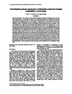
the globe. At each pixel location, the warmest mean monthly SST was added to the global, 9 km resolution climatology field (4096x2048 pixels). Fig. 2 maps the difference values obtained when the 50 km MMM SST climatology is subtracted from the Pathfinder MMM SST climatology (version at 50 km). Throughout the tropics, the Pathfinder climatology is warmer by up to 1°C (white areas), averaging +0.39°C. The negative biases in the 50 km climatology are due to fundamental differences between the Multi-Channel SST (MCSST) algorithm data used in the 50 km version and the NLSST (Non-Linear SST) data in the Pathfinder version. Certain errors retained in the uncorrected MCSST database include cold biases due to inferior cloud clearing. Given the agreement demonstrated between Pathfinder SSTs and in situ temperatures (Figs. 1a and 1b), the 9 km MMM SST climatology is assumed to provide accurate threshold temperatures for HotSpot anomalies. Comparison of HotSpots prepared using 50 km and 9 km climatologies indicate the differences in anomaly levels and patterns that might have bearing on the amount of heat stress required to force bleaching.
Fig. 2 Difference between the original 50 km and new Pathfinder MMM SST climatologies, obtained by subtracting the 50 km (MCSST) climatology from the Pathfinder (NLSST) climatology (50 km version). Light gray areas indicate where the Pathfinder climatology is 0°C-0.5°C warmer than the original 50 km version. White areas indicate where the Pathfinder climatology is 0.5°C-1°C warmer, particularly in the tropics (shown). Results Australia 1998 Annual composite 50 km and 9 km HotSpot maps for Australia (Fig. 3) show an overall decrease of 0.25°C to 0.5°C in 9 km anomaly levels along the
northeast coast and the Great Barrier Reef (GBR). The black areas in the 9 km map indicate where Pathfinder data have been excluded along the GBR, due to high SST gradients. Western Australia and the eastern Indian Ocean also show some variation in anomaly patterns and levels.
Fig. 3 Comparison of 50 km (left) and 9 km (right) 1998 Annual Composite HotSpot maps for Australia. The Great Barrier Reef, northeast coast of Australia, is marked in the 9 km map by a chain of masked pixels. Scale represents anomaly level in °C. Peak 1998 HotSpots occurred along the GBR in February 1998 (Berkelmans and Oliver 1999). The 9 km map (determined using the warmer Pathfinder climato-
logy) shows anomaly levels extending from shore to the outer reefs that are up to 0.5°C cooler throughout the region than anomalies in the 50 km composite. The
highest 9 km anomalies occurred well inshore, consistent with observed locations of high (10-30% of coral) to extreme (>60% of coral) levels of bleaching (Berkelmans and Oliver 1999). Inshore bleaching was aided by stratification and heating due to low winds and clear skies (Skirving et al. 2000). Offshore reefs experienced significantly lower levels of bleaching, with only 14% showing high levels (10-30% of coral) and none showing extreme levels. In the 9 km version, anomalies virtually disappear in the northernmost area, consistent with lack of bleaching on outer reefs, to a few areas of high (10-30%) bleaching inshore (Berkelmans and Oliver 1999). Indian Ocean Comparison of 9 km and 50 km annual composite HotSpot maps for the Indian Ocean (Fig. 4) indicates an overall marked decrease, with several exceptions, in anomaly levels in the 9 km version, particularly through the equatorial and tropical latitudes and the northwest Indian Ocean. Again, this decrease reflects the higher threshold temperatures in the Pathfinder version of the MMM SST climatology over those of the 50 km version, as well as the fundamental differences between MCSST and NLSST satellite data. The Indian Ocean experienced very high temperatures (3- 5°C above normal; Wilkinson
et al. 1999) and severe coral bleaching and mortality in particular areas. The coasts of Kenya and Tanzania are marked by hot water in both versions, consistent with high levels of bleaching reported there. Bleaching in Madagascar, which appears very hot in the 50 km version, ranged from 0% to 40-80% (in one area), more in keeping with the decreased anomaly levels in the 9 km version. The Maldive Islands experienced peak bleaching in April 1998. The 9 km map shows excellent detail of the variability in the anomalies, and up to 0.5°C lower anomaly levels along the perimeter of the main hot area surrounding the southern Islands. Severe catastrophic bleaching (80% shallow; 45% from 10-30 m deep) was followed by 95% mortality of shallow water corals (8090% overall; Wilkinson et al. 1999). The Lakshadweep Islands immediately north of the Maldives experienced similar mortality later in the season (May-June; Wilkinson et al. 1999). In the Bay of Bengal, the Andaman Islands suffered bleaching averaging 80%, followed by 70% average mortality (Wilkinson et al. 1999) between May and June 1998. The 9 km map shows high anomalies along the Andaman chain; the 50 km climatology did not identify these anomaly levels and may not have predicted bleaching there. Lower 9 km anomalies along the west Thailand coast are consistent with a lack of bleaching in that area.
Fig. 4 Comparison of 50 km (left) and 9 km (right)1998 Annual Composite HotSpot maps, Indian Ocean. K, T = Kenya and Tanzania. M = Madagascar. L = Lakshadweep Islands. T = Thailand. A = Andaman Islands. North Caribbean Annual composite HotSpot maps for the Caribbean area (Fig. 5) show a major difference, with the 9 km map showing a large (0.25-0.5°C) decrease in anomaly levels
along with changes in spatial patterns in some areas. 9 km Caribbean climatology values are generally warmer (Fig. 2), in large part accounting for the decreased anomaly levels vs. the 50 km map.
Fig. 5 Comparison of 50 km (left) and 9 km (right)1998 Annual Composite HotSpot maps for the Florida Keys, Bahamas, and northern Caribbean. FLK = Florida Keys. B = Bahamas. PR = Puerto Rico. Despite the lower 9 km anomalies, bleaching of inshore corals in the Florida Keys began in mid-June
through July. By mid August, severe bleaching was reported in inshore patch reefs (50-90%), coincident with
32°C in situ SSTs (2°C higher than the 9 km climatology threshold SST). Significant bleaching was reported from the central Bahamas, in San Salvador patch reefs as well as in the inner reefs at Lee Stocking Island (Exuma Cays). By September the central Bahamas showed extensive bleaching (up to 80% cover from 15-20 m). Bleaching occurred in southeastern Puerto Rico, but was not considered severe, with water temperatures under 31°C (1°C above threshold) throughout the south area. Offshore reef areas of the Florida Keys reported 60-80% bleaching at depth, and 80-100% bleaching in shallow areas. By late September, 9 km anomaly levels for the Florida Keys and Bahamas had dropped to normal. Discussion The Pathfinder MMM SST climatology is based on more accurate, calibrated SST data than the 50 km MCSST climatology (of Strong et al. 1997). As a result, 9 km threshold temperatures are, with a few exceptions, slightly warmer throughout the tropics than the 50 km MMM SST climatology. This has allowed us to produce retrospective 1998 HotSpot maps that most accurately reflect field conditions and reported incidences of bleaching, its severity, and timing. The 9 km climatology predicted bleaching in areas missed by the 50 km version, and in most other areas indicated that lower anomaly levels were associated with bleaching. We conclude that the generally lower anomaly levels mapped with the Pathfinder climatology closely monitor actual field conditions and provide quantitative data on the amount and variability of thermal stress surrounding reefs, at an appropriate scale. High-resolution HotSpot maps have to be created at least five months after the actual field season, due to the calibration and processing lag time required for Pathfinder data. For real time forecasting, 50 km NESDIS HotSpot maps are currently the best tool available. We have created a 50 km Pathfinder MMM SST climatology to replace the original MCSST version. The 50 km Pathfinder climatology was implemented into NOAA/NESDIS HotSpot mapping in early 2001 in test mode. The new climatology, combined with new NOAA16 AVHRR SST data, predicted bleaching in American Samoa in 2001; the anomalies forcing this event were not identified by the original climatology. 50 km HotSpot mapping is slated for processing upgrades and a transition to full operational status in the near future. Highresolution HotSpot maps will be made available through the NOAA/NESDIS HotSpot web page as soon as Pathfinder data become available after calibration and processing Acknowledgements We gratefully acknowledge the field researchers and marine managers who reported bleaching events via NOAA’s Coral Health And Moni-toring Program (CHAMP; http://www.coral.noaa.gov/), and who corresponded with us via email. R. P. Stumpf
(NOAA/NOS) contributed computer resources and expertise. W. Skirving (Australian Institute of Marine Sciences) provided helpful discussions. References Berkelmans R, Oliver J K (1999) Large-scale bleaching of corals on the Great Barrier Reef. Coral Reefs 18: 55-60. Casey K S, Cornillon P (1999) A comparison of Satellite and in situ-based Sea Surface Temperature Climatologies. Jour Climate 12: 1848-1863. Goreau T J, Hayes R (1994) Coral bleaching and Aocean hot spots.@ AMBIO 23: 176-180. Jokiel P L, Coles S L (1990) Response of Hawaiian and other Indo-Pacific reef corals to elevated temperatures. Coral Reefs 8: 155-162. Kearns E J, Hanafin J A, Evans R H, Minnett P J, Brown O B (2000) An independent assessment of Pathfinder AVHRR sea surface temperature accuracy using the Marine--Atmosphere Emitted Radiance Interferometer. Bull Amer Met Soc 81: 1525-1536. Kilpatrick K A, Podesta G, Evans R (2001) Overview of the NOAA/NASA Pathfinder algorithm for sea surface temperature and associated matchup database. Jour Geophys Res 106: 9179- 9197. Reynolds R, Smith T (1995) A high-resolution global sea surface temperature climatology. Jour. Climate 8: 1571-1583. Skirving W, Guinotte J, Done T (2000) Satellite sea surface temperature and coral bleaching: the 1998 GBR story. Abs, Mini Symp E2B, 9 th Int Coral Reef Symp: 265 pp Strong A E, Barrientos C, Duda, Sapper J (1997) Improved satellite techniques for monitoring coral reef bleaching. Proc, 8 th Int Coral Reef Symp 2: 14951498. Vasquez J, Perry K, Kilpatrick K (1998) NOAA/NASA AVHRR Oceans Pathfinder Sea Surface Temperature Data Set User's Reference Manual Version 4.0. JPL Publication D-14070 available online a hhtp://podaac.jpl.nasa.gov/. Vasquez J, Sumagaysay R (2001) A comparison between sea surface temperatures as derived from the European remote sensing Along-Track Scanning Radiometer and the NOAA/NASA AVHRR Oceans Pathfinder data set. Bulletin Walton C C, Pichel W G, Sapper J F, May D A (1998) The development and operational application of nonlinear algorithms for the measurement of sea surface temperatures with the NOAA polar-orbiting environmental satellites. Jour Geophys Res 103: 27,999-28,012. Wilkinson C, Linden O, Cesar H, Hodgson G, Rubens J, Strong A E (1999) Ecological and sociological impacts of 1998 coral mortality in the Indian Ocean: an ENSO impact and a warning of future change? Ambio 28: 188-196.