Jan 19, 2005 - An Automated Valuation Model (AVM) named âGeo-Information ... GIS uses digital technology, which combines hardware and ... buyer and a willing seller in an arm's length transaction after proper marketing wherein the.
INTEGRATING ARTIFICIAL NEURAL NETWORKS AND GIS FOR SINGLE-PROPERTY VALUATION Abdul Ghani Sarip (Department of Estate Management, Faculty of the Built Environment, University of Malaya, Kuala Lumpur, Malaysia) Abstract: The sales comparison approach to valuing a single property combines expert qualitative evaluation with quantitative analysis of the subject property along with comparables. Predicted values are then evaluated before a final valuation is rendered. The traditional hedonic approach involving the application of multiple regression, is problematic and faces some data management problems. This is especially when large dataset is being analysed and the effect of location attribute cannot be explained explicitly. An Automated Valuation Model (AVM) named “Geo-Information Neural System” (GINS) is developed as an alternative for use in the valuation of single-residential property. This system integrates a Geographic Information System (GIS) technique with Artificial Neural Networks (ANN) modeling. It involves the establishment of a GIS database management system for all detached property in Damansara Heights, Kuala Lumpur. GIS is utilized for location distance measurements, spatial queries and thematic mapping whilst ANN is employed to replicate the way the human brain might process data by learning relationships, in this case the one existing between property characteristics such as physical and location attributes and sales price. A sample of 100 sales of detached houses is taken. The trained neural network model is then used to predict the probable value of a residential property. The model is built on a GIS platform, which will allow for GINS automation as well as the conduct of interactive valuations. A graphical user interface is developed for seamless integration and user interaction. The results indicate that GINS provides an efficient AVM tool that provides superior residential property valuations, while accuracy is improved by minimizing the influence of subjective judgments. The technique may be used to check valuations generated by more traditional methods as well as further improve the overall quality of single-property valuations. [Keywords: single-property valuation; automated valuation model; geographic information system; artificial neural networks]
Introduction The purpose of this article is to demonstrate the potential of computer modelling artificial neural network and GIS to improve the accuracy of value estimation for residential property. Property valuation is no longer a traditional business that relies only on expert opinions of value. The profession is now facing greater transformation in the valuation process and methodology, along with innovations in information technology (IT). Technology is having profound effect on the profession, as well as influence on the property valuation process, largely pressured by the needs of today’s clients who demand quick, easy and more objective process to arrive at the opinion of value. The needs somehow motivate dependency on automated valuation that allows clients to get faster and better results. Advancement in IT changes how the process is carried out and leads to more analytical applications within the valuation profession.
Regression analysis and other advanced statistical techniques have been used to automate valuation with varying degrees of success (Wyatt, 1996). Automated valuation modelling (AVM) is one of the new techniques in assessing single-property value (Waller, 1999; Robbins, 2001). Based on computing model, it is recognized as a new valuation tool in the 21st century (Waller et al., 2001). AVM is able to carry out automated valuation process, either in personal computers or more integrated systems such as on-line over wide area network and the internet. Robbins (1998) reported the advantages of AVM in property valuation process; “AVMs are used to reduce the time and costs associated with loan underwriting and help the valuer prepare more accurate and supportable valuation. The objective should not be to replace the valuer but rather to increase the valuer’s efficiency in rendering an opinion of value.” Among the AVM techniques are statistical-based hedonic pricing models such as multiple regression (MRA) and price-time indexing and artificial intelligence-based such as neural networks (ANN), expert systems and case-based reasoning (Waller et al., 2001). Empirical analyses show that these techniques have proven their success in producing reasonably and acceptable valuation of single-property. MRA is the most popular quantitative technique in property valuation. It has been applied in various residential property valuations to assist valuer in statistical analysis and complement the traditional sales comparison approach. An alternative to multiple regressions is intelligent-based ANN. Similar to MRA, ANN models the relationships between property attributes and sales price. The main difference is in its structure. ANNs are distributed arrays of highly interconnected processing elements. Each connection has an associated strength or weight. Processing at each node involves a weighted sum of each connection forming a single input to a non-linear transfer function. The output from each node becomes the input to successive nodes (Lewis, 1999). Many researchers have approved that ANN is unique by its model structure and algorithms that are not only intelligent, but can emulate comparison approach and can be applied to prediction and regression tasks in valuation analysis. A number of renowned valuation firms have adopted more advanced database systems and analytical techniques such as Geographic Information System (GIS) that allow for not only easy, but more efficient and effective management of spatial data (Almond et al, 1997). This is true as the greater availability of data today leads to a new set of methods for analysing properties. The ability to apply more advanced tools to analyse data allows for that quicker response. Those methods tend to be based on quantitative analysis as well as GIS (MattsonTeig, 2000). GIS uses digital technology, which combines hardware and software to meet user needs in handling spatial data to produce graphical output. GIS-based automated appraisal systems – on desktop computers and over the internet will inevitably and profoundly change the appraisal industry (Castle, 1998). In this paper, we highlight how ANN and GIS technology provide the valuation profession with new technique. The aim is to present the development of an AVM named “GeoInformation Neural System” (GINS). The following section reviews the relevant research in the literature about a new quantitative method in single-property valuation using GIS technology and ANN computing model. Data and methodology for the development of GINS are described in Section 3 and GINS implementations in single-property valuation are discussed in Section 4. We conclude the paper by summarizing the results and conclusion. 2
Automated Valuation Model Valuation is the process of assigning a value to a property at the date of valuation for specific purposes. Valuation exists as a field because there is uncertainty on the part of potential buyers, sellers, investors and others. This stems in part from the complex nature of the product (the real estate itself), and from the uninformed, imperfect, complex nature of the real estate market (Kinnard Jr., 2001). The sales comparison approach is the most common method in single-property valuation especially for residential (Ismail, 1997). It is a method of estimating the market value of a subject property by analysis of sales of similar properties. Market value is the estimated amount for which a property should exchange on the date of valuation between a willing buyer and a willing seller in an arm’s length transaction after proper marketing wherein the parties had each acted knowledgeably, prudently and without compulsion (International Valuation Standard, 2003). The philosophy is based on the existence of direct relationships between market value of a subject property and selling prices of comparison properties in the market represent competitive investment alternatives. Valuation factors such as physical characteristics, location, quality and other economic factors are considered in the comparable analysis. These factors affect the supply and demand of property and expressed in valuation models. In practice, valuers often rely on past transaction data to arrive at a market value. Adjustments are made for any differences using comparison unit and become the basis for comparison. Using AVM, valuers can produce valuations that take into account more economic factors than usually are considered in conventional single-property valuations. AVM is a computer program that utilise relevant property information to calculate a value for a specific property. The sales comparison models in AVM generally have the following form: V = f(x1, x2, x3, ...xn)
[1]
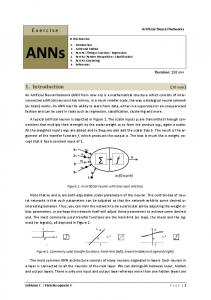
where V is estimated sale price; f is ‘a function of’ and (x1, x2, x3, ...xn) are location and property characteristics. Models can be in the form of additive, multiplicative or hybrid. ANN modelling may be used to calibrate the models. Traditionally, automated valuation is commonly used to estimate the value of residential property in computer-assisted mass-appraisal (CAMA), mostly for statutory purposes such as rating and taxation (O’Rouke, 1998; Rossini, 1999). However, AVMs are now getting wide acceptance as an alternative to estimate the value of single-property (Robbins, 2001; Waller et al, 2001). The important aspects of AVM are quantitative-based analysis, consistency, speed, ease of use and reasonable accuracy (Valentine, 1999). Although AVM may not provide the most accurate estimate of an individual property value, it may provide better indication and objective justification of the value. Artificial Neural Networks Neural network is a system of a massively distributed parallel processing that has a natural propensity for storing experiential knowledge (Gopal, 1998). An ANN is composed of a set of nodes and a number of interconnected processing elements. ANNs use learning algorithms to model knowledge and save this knowledge in weighted connections, mimicking the function 3
of a human brain (Turban and Aronson, 2001). The nodes generally have three layers: input nodes, hidden nodes and an output node. Figure 1 shows a generic model of an ANN.
Nodes (Neurons) Inputs
Output Processing elements (Networks) Input Layer
Hidden Layer
Output Layer
Figure 1: A generic ANN model The most popular ANN model used in prediction and regression tasks is Multi-layer Perceptron (MLP) with Feed-forward Back-error Propagation (BP) type of learning algorithm, or simply as MLP-BP. The model has three layers interconnected to each other’s nodes by the networks (Figure 1). Input nodes receive independent variables while hidden nodes run the learning process before passing on to output node (a dependent variable) for prediction. Each network carries weights (w1, w2, w3). These weighted connections act as coefficients to the input nodes. The hidden nodes (sum of the weighted inputs) compute network output (feedforward) through a non-linear activation function, determining the difference (error) to the expected output (actual output). This error is distributed among the connections weights (back-propagation) in order to progressively reduce the error. These steps are repeated for many cycles in the learning phase until the desired error level is obtained. The network is then verified with “out-of-sample” data to verify the generalization capability. Figure 2 illustrates the MLP-BP model. Inputs
X1 X2 X3 X4 X5 Xn
Actual Output
Desired Output
Y = f(X) Error Back-Prop Algorithm: Adjust weights using error (Actual Output – Desired Output)
Figure 2 : ANN MLP-BP model 4
ANN’s back-error propagation learning algorithm has been investigated quite extensively to model residential property value by many researchers. For examples, refer to Borst, 1992; Evans et al, 1992; Do and Grudnitski, 1992; Tay and Ho, 1992; Worzala et al., 1995; McCluskey et al., 1997; Kwon and Kirby, 1997; McGreal et al., 1998. Integration with Geographic Information System Environmental Systems Research Institute (ESRI) (1990) defines GIS as an organized collection of computer hardware, software, geographic data and personnel designed to efficiently capture, store, update, manipulate, analyse and display all forms of geographically referenced information. Previous studies have acknowledged that property valuations benefited from the application of GIS in many forms (see Longley et al, 1993; Fung et al, 1995; Rodriguez et al, 1995; Wyatt, 1995; Wyatt, 1996; Wyatt, 1997; McClusky et al, 1997; Thrall, 1998; and Castle, 2000). One of the GIS’s significant applications is property location analysis in comparison approach. For example, Rodriguez et al. (1995) studied on the application of GIS “shortest path” algorithm to analyse the effect of location on property value. They concluded that, “distance variables are easily produced with GIS such as the shortest-path algorithm that produces a superior distance variable relative to the traditionally used straight-line distance variable and has significant relationship with residential sales prices. The GIS created variables expedite analysis within or outside the GIS environment.” According to Thurston (2002), the integration of ANN modelling in GIS can be applied in many applications to improve decision making process. Experimental studies have been carried out on the integration of ANN model and GIS system in property valuation (Brondino and Silva, 1999; Moon and Hagishima, 2001; and Hall and Morgan, 2001). For example, Hall and Morgan (2001) developed an automated valuation system named “Spatial Aspect: Computer-Assisted Valuation Decision Support Tool”. This software integrates GIS and ANN modelling. Sales of 181 residential properties in Turks & Caicos Islands, Central America were used as sample study. Attributes of property were trained and tested in ANN to get the predictive function. GIS was utilized for spatial analysis and visualization. Property location factor was analysed in GIS to measure accessibility, while comparison analysis was carried out spatially to produce graphical outputs. A raster-format spatial distribution of property prices and elevation models that shows parcel contours and the neighbourhood boundaries were visualised. The ANN predictive function was then integrated with GIS location to determine a property value. Data and Model Design The first step in AVM modelling is data collection. Property specific data were acquired from the government’s Department of Valuation & Property Services. Sales of 138 detached properties were gathered and thoroughly analysed to select the most recent transactions and good data. Spatial data that consists of digital map of property parcels and building footprints were acquired from the GIS Unit of Kuala Lumpur City Hall. Data were categorized as either 5
qualitative or quantitative and edited in MapInfo. Qualitative data were coded to a numeric form. Table 1 shows the data types and its representation used in this analysis. Table 1: Data Representation Attributes Selling price (RM mil) Lot area (sqm) Building MFA (sqm) Building AFA (sqm) Building age No. of storey No. of bedroom Repair condition Finishes quality Distance to exit points (km) Distance to commercials (km) Distance to schools
Data Types Continuous numeric Continuous numeric Continuous numeric Continuous numeric Continuous numeric Discrete numeric Discrete numeric Categorical Categorical Continuous numeric Continuous numeric Continuous numeric
Value (Min – Max) 1.50 – 5.65 441.000 – 1275.331 158.500 – 568.734 22.000 – 380.000 2 – 35 2, 3 3, 4, 5, 6 Good, Average Good, Average 0.1 – 5.0 0.05 – 3.5 0.05 – 3.5
Representation Numeric Numeric Numeric Numeric Numeric Numeric Numeric One-of-N code One-of-N code Numeric Numeric Numeric
The construction of ANN valuation model begins with learning process in Tiberius. Figure 3 illustrates a neural network model to property valuation in the study. Input training and testing datasets that are stored in Microsoft Access are called and form an ANN MLP-BP structure. ANN learning computes the prediction output and is adjusted by an error term with the required output to minimize mean absolute error (MAE), the same way to reduce root mean squared error (RMSE) or E2 (Figure 4). Bias = 1 Land Area Main Floor Area
Bias = 1
Ancilary Floor Area Building Age
Sale Price
No. of Storey No. of Bedroom Repair Condition Finishes Quality Weights
Location Index (Distance) Input Layer
Weights
Hidden Layer
Output Layer
Figure 3: ANN property valuation model
6
Compute output
Adjust Weights
NO
Is desired output achieved?
YES
Progress Bar
STOP
Figure 4: ANN learning in Tiberius As the training run, Tiberius identifies the factors that contribute the most to the inputs in relation to sale prices and show the results when the desired output is obtained (Figure 5).
Figure 5: ANN learning result and predictive model The location value analysis provides a means of adjusting for location in econometric modelling. Distance measurement functions are utilized based on “the shortest straight line” algorithm in MapInfo. In this study, we use accessibility and proximity factors to measure distances from a property to value influence centres such as commercial centres and main exit points of the neighbourhood. Figure 6 exhibits the main exit points as applied in the study while Figure 7 shows an example of distance measurement for proximity in MapInfo.
7
Damansara Heights To Kuala Lumpur City Centre
Exit 3
Damansara Exit 1
Exit 4 Bangsar
Petaling Jaya Shah Alam
Exit 2
KL Sentral
Figure 6: Main exits of Damansara Heights
Figure 7: Proximity analysis Conceptual Model The model is conceptually illustrated in Figure 8. It integrates various computer applications. Tiberius Neural Data Mining is employed for analysis of property attributes and the construction of predictive modelling. MapInfo Professional is utilised to acquire and analyse spatial data, besides location spatial analysis, queries and thematic mapping. Microsoft Access is used for relational database to work as storage and data editing. A Visual Basic graphical user interface (VB GUI) is developed for seamless integration between applications and the automation process of property valuation interactively. As the figure shows, AVM generates tabular and spatial data and generates a property value by user input. Upon user interaction, GINS releases a trained neural network, which is the “goodness-of-fit” model from Tiberius and embedded into VB GUI and links to MapInfo for spatial visualisation. 8
Tiberius
Spatial Database
MapInfo Professional
Property Location Attributes (GIS Model)
MapInfo GIS: Spatial Analysis of Accessibility and Proximity
Spatial Layer (Interactive Valuation)
Thematic Maps: Value Map
ANN Learning Process and Testing Network (Back-prop Algorithm)
Generalized Forecasting Model (ANN Valuation Model)
Automated Valuation Modeling (AVM)
Property Value @ RMx.xx mil
Tabular Database (Ms Access)
New Data: Subject Property (Input Attribute Value)
Valuation Proforma
Historical Data: Property Physical Attributes
Attributes Database
Visual Basic GUI
Figure 8: GINS conceptual design GINS Implementation The model is implemented in prototype software (GINS) that operates within Microsoft Windows. This user-friendly software generates tabular and spatial output and provides user interface with dialog windows, menus and toolbars. Tiberius, which is GINS valuation engine comes in a dynamic link library package and cannot be customized in the system GUI. GINS can only invoke the whole application through a shell function into VB multiple document interface (MDI) form. However, ANN weight file can be modified in GUI by Tiberius software development kit. It is then linked to spatial layers in MapInfo using ID number. Figure 9 shows the MDI forms to begin GINS and its menus and toolbars.
Figure 9: GINS MDI forms
9
Property attributes in Microsoft Access that can read by Tiberius are written out from MapInfo to a dbf. file format. Tiberius enables the construction of non-linear regression model and uses its back-propagation algorithm in multi-layer perceptron neural networks for the construction of predictive modelling. Spatial layer is created in MapInfo street file together with parcel and building layers which are previously geocoded. Property location indexes are built in MapInfo to measure shortest path distance for each property to all street segments to account for accessibility and proximity. The indexes are then sent to Tiberius for modelling with other property attributes. The program runs several training and testing to develop a function that yields the prediction of sale price as a function of all property attributes. The “goodness-of-fit” model is run using the subset of variables that proves significant after adjustment of response coding to correct any error term. Once the model is developed in Tiberius, the coefficients of ANN prediction model could be applied to tables in MapInfo. Call function is built in VB program that could be accessed from within the proprietary valuation engine that is GINS. User can either click at a particular property or comparable properties in the spatial layer or enter property specific attributes under valuation pull-down menu. Clicking evaluate, the system multiplies the values entered by their respective coefficients and add in the model constant term and return the market value of the subject property. Figure 10 illustrates the valuation process in GINS.
Figure 10: Valuation process in GINS Results The ANN predictive model is verified with new property data. The experiment indicates favourable prediction results with the actual property prices of detached houses. Minimum and maximum errors are 1% and 11% respectively, while median error is 5% and 6% (Table 2).
10
Table 2: Results of ANN predictive modelling No.
ANN Model Output (RM mil)
Actual Property Prices (RM mil)
Value Difference (RM mil)
Error (%)
1 2 3 4 5 6 7 8 9 10
1.947 2.193 2.538 2.071 1.776 2.205 1.788 2.895 2.334 1.807
2.100 2.030 2.480 2.000 1.750 2.300 1.680 1.100 2.180 1.900
-0.153 0.163 0.058 0.071 0.018 -0.095 0.108 -0.206 0.154 -0.093
7.86 7.43 2.29 3.43 1.02 4.31 6.04 10.87 6.59 5.15
Therefore, from this perspective, ANN valuation model in this study gave a reasonable and acceptable value of property. Conclusion The model demonstrates the potential of GIS and ANN as emerging tools in acquiring and analysing spatial and attributes data. The model application can significantly reduce time and cost required to value a property, while enhancing the accuracy of value estimates. The automated valuation system product consists of a shell built around a valuation engine, which allows users to perform specific tasks and obtain desired outputs. This shell can be customised to meet special user needs and to adapt to changing data conditions. Nevertheless, the valuation core remains relatively stable and will require alteration only when enhancements are added (Robbins, 1998). Although the results from this study seem appealing in enhancing valuation technique, there are still concerns need to be further research in future studies. For instance, GINS conceptual model can be improved for other application domain and can be enhanced to meet current market and user needs. Hence the future study will try to identify more variables to be added in ANN valuation model, i.e. economy and socio-economic factors. References Almond, N.I., Lewis, O.M., Jenkins, D.H., Gronow, S.A. and Ware, J.A. (1997). Intelligent Systems for the Valuation of Residential Property. RICS Cutting Edge ‘97. Bell, D. (2000). Software Engineering: A Programming Approach. England: Addison-Wesley. Borst, R.A. (1992). Artificial Neural Networks: The Next Modelling/Calibration Technology for the Assessment community? Property Tax Journal. 10. 69–94. Brondino, N.C.M. and da Silva, A.N.R. (1999 Sept). Combining Artificial Neural Networks and GIS for Land Valuation Process. Paper presented at the 6th International Conference on CUPUM, Venezia, Italy, 8–11, September. Castle, G.H. (1998). GIS: Meeting the Information Demand. Valuation Insights and Real Estate Investor. 42(1). 66–71. Castle, G.H. (Ed.) (1998). GIS in Real Estate: Integrating, Analyzing and Presenting Locational Information. Illinois: Appraisal Institute. Castle, G.H. (2000). Property Valuation: Sales Appraisals Made Easy. Business Geographics. 8(8). 22.
11
Do, A.Q. and Grudnitski, G. (1992). A Neural network approach to residential property appraisal. The Real Estate Appraiser. 58(3). 38–45. ESRI (1990). Understanding GIS: The ARC/INFO Method. Redlands, Calfornia: Environmental System Research Institute. Evans, A., James, H. and Collins, A. (1992). Artificial Neural Networks: an Application to Residential Valuation in the UK. Journal of Property Valuation and Investment. 11. 195-204. Fung, S.F., Hsiang-te, Kung and Barber, M.C. (1995). The Application of GIS to Mapping Real Estate Values. The Appraisal Journal. 63. 445-452. Gopal, Sucharita (1998). Artificial Neural Networks for Spatial Data Analysis. NCGIA Core Curriculum in GIScience at http://www.ncgia.ucsb.edu/giscc/units/u188/u188.html, posted Dec. 22, 1998. Hall, G.B. and Morgan (2001). Spatial Decision Support System: Spatial Aspect Project. University of Waterloo, Canada. Unpublished. International Valuation Standards Committee (2003). International Valuation Standards. UK: England at http://www.ivsc.org/ivsc.html, posted Jan. 19, 2005. Ismail Omar (1997). Penilaian Harta Tanah. Kuala Lumpur: Dewan Bahasa dan Pustaka. Kinnard Jr., W.N. (2001). New thinking in appraisal theory. The Appraisal Journal. 69(3). 235–243. Kwon, O. and Kirby, E.J. (1997). Farm Appraiser: A Neural Network for Agricultural Appraisal. Paper presented at the 11th Annual Midwest Computer Conference. Lewis, O.M. (1999). The Use of Artificial Intelligence Techniques to Assist in theValuation of Residential Properties. University of Glamorgan, U.K: PhD Thesis. Unpublished. Longley, P., Higgs, G. And Martin, D. (1993). A GIS-Based Appraisal of Council Tax Valuations. Journal of Property Valuation and Investment. 11(4). 375–383. Mattson-Teig, B. (2000). Property owners look for appraisers to analyse this. National Real Estate Investor. 42(1). 66–71. McClusky, W.J., Deddis, W., Mannis, A., McBurney, D. and Borst, R. (1997). Interactive application of computer assisted mass appraisal and geographic information systems. Journal of Property Valuation and Investment. 15(5). 448–465. McGreal, S., Adair, A., McBurney, D. and Patterson, D. (1998). Neural networks: the prediction of residential values. Journal of Property Valuaton & Investment. 16(1). 57–70. Moon, T. and Hagishima, H. (2001 July). Integrated Simulation System of GIS and ANN for Land Price Appraisal. Paper presented at the 7th International Conference on CUPUM, University of Hawaii, Honolulu, 18-21 July. O’Rouke, A. (1998). Automated Valuation Models: threat and opportunity. Appraisal Today. Sept,1998. Robbins, M.L. (1998). Overview and Case Studies in GIS-Based Appraisal in Castle, G.H. (Ed.). GIS in Real Estate: Integrating, Analyzing and Presenting Locational Information. Illinois: Appraisal Institute. Robbins, M.L. (2001). The Taurean Residential Valuation Service Report, July 19, 2001. Unpublished. Rodriguez, M., Sirmans, C.F. and Marks, A.P. (1995). Using Geographic Information System to Improve Real Estate Analysis. The Journal of Real Estate Research. 10(2). 163–173. Rossini, P. (1999 Jan). Accuracy Issues for Automated and Artificial Intelligent Residential Valuation Systems. Paper presented at the International Real Estate Society Conference, Kuala Lumpur, 26-30 January. Tay, D.P.H. and Ho, D.K.H. (1992). Artificial Intelligence and the Mass Appraisal of Residential Apartments. Journal of Property Valuation and Investment. (10)2. 525–540. Thrall, G.I. (1998). GIS applications in real estate and related industries. Journal of Housing Research. 9(1). 33–59. Thurston, J. (2002). GIS & Artificial Neural Networks: Does Your GIS Think? GISVision Magazine. February, 2002.
12
Turban, E. And Aronson, J.E. (2001). Decision Support Systems and Intelligent Systems. New Jersey: Prentice Hall. Valentine, L. (1999). Automated valuation models speed the appraisal process. ABA Banking Journal. 91(1). 46–48. Waller, B.D. (1999). The impact of AVMs on the Appraisal Industry. Appraisal Journal. 67(3). 287 Waller, B.D., Greer, T.H. and Riley, N.F. (2001). An Appraisal Tool for the 21st Century: Automated Valuation Models. Australian Property Journal. 36(7). 636–641. Wang, W. (1998). Visual Basic 6 for Dummies. U.S: IDG Books Worldwide, Inc. Worzala, E., Lenk, M. and Silva, A. (1995). An Exploration of Neural Networks and Its Application to Real Estate Valuation. The Journal of Real Estate Research. 10(2). 185–201. Wyatt, P. (1995). Property Valuation Using a Geographical Information System. University of Brighton, UK: PhD Thesis. Unpublished. Wyatt, P. (1996). Practice Paper: Using a geographical information system for property valuation. Journal of Property Valuation and Investment. 14(1). 67–79. Wyatt, P. (1997). The development of a GIS-based property information system for real estate valuation. International Journal of Geographical Information Science. 111(5). 435–450. Acronyms and Abbreviations ANN - Artificial Neural Networks AVM - Automated Valuation Model BP - Back-propagation CAMA - Computer-assisted Mass-appraisal ESRI - Environmental Systems Research Institute GINS - Geo-information Neural System GIS - Geographical Information System GUI - Graphical User Interface IT - Information Technology MDI - Multiple Document Interface MLP - Multi-layer Perceptron MRA - Multiple Regression Analysis VB - Visual Basic
13
Appendix A : GINS Summary Neural Network Structure Architecture Algorithm (Training) Objective Target Output Dataset Dataset Date Dataset Ratio
: 3-layer perceptron fully interconnected neurons : Back-error Propagation : To predict selling price of a house within 10% error of estimation : Actual selling prices of houses in training dataset : Estimated selling price of a house : 100 sales data of detached houses in Damansara Heights, Kuala Lumpur : 3-year from 2000 – 2002 : Training > Testing > Validation (80:10:10)
How it works? • • • •
Uses Sales Comparison Approach: Value = Comparisons ± Adjustments ANN adds the intelligent factor into data analysis. Non-linear processing through hidden layer using summation and activation function. Algorithm: o Pass training data through network. o Adjust network weights to reduce error. o Validate network with out-of-sample data. o Use network to predict real data. Bias (error)
Land area
Bias (error)
Building main floor area Building ancillary floor area Year completed Number of storey Number of bedrooms
Selling Price
Condition of repair
PREDICTION (DEPENDENT VARIABLE)
Quality of finishes Location (distance) INDEPENDENT VARIABLES
Weights INPUT LAYER (X)
Weights
HIDDEN LAYER
OUTPUT (Y)
14
Guides on how to use GINS to value a property
File Exit
Database Update ---------------------------Registered Owner Property Information Sales Data
Neural Training Data -------------------------Run Training and Testing -------------------------Predictive Modeling
Location Accessibility to exit points Proximity to non-residential properties
Valuation Select Property Value Prediction Valuation Profile -----------------------------Spatial Queries
Maps Thematic Mapping Parcel Map Value Map
15
Step-by-step Guide 1. Browse through the entire menu (Database; Location; Neural; Valuation; Maps) in the main interface to see the drop-down sub-menu functions. 2. Use icons to manipulate the graphic features. 3. Click on Database menu to browse the attributes and spatial data of sales and property information. 4. Click on Location menu to see the spatial analysis of property location. The location is calculated based on MapInfo ‘straight line distance’ algorithm of the following criteria: o Accessibility measures distances from a property to four exit points of Damansara Heights. o Proximity measures distances from a property to nearby commercials and schools. o The distances values then feed into neural networks database. 5. Click on Neural menu to begin artificial neural networks modeling process. o User determines the desired target (say, error of estimation < 10%). o Open the database and selects property variables for inputs and output. o Determine the neural networks structure – hidden layer. o Begins Training on the property physical and location data and simultaneously Testing the network through the progresses. o User retains the best network (Predictive Modeling) based on the progress charts windows and save as weight file to pass on to Valuation. 6. Valuation menu is the core in GINS that performs valuation procedure. o User can make Spatial Queries (SQL) based on specific requirements. o User Select Property to value. o The system will generate a subject property value through Value Prediction. o Alternatively, user can enter property inputs in Value Prediction. o Valuation Profile shows the estimated value of the subject property and related summary. 7. Click on the Maps menu to view the graphical visualization of thematic maps of distribution of values.
Benefits of GINS to Single-Property Valuation 1. Improved replication of valuations and decreased subjectivity. 2. Greater reduction in required time to process valuations (greater automation). 3. Incorporate existing spatial data and spatial analysis. 4. GIS visualization and exploration.
16