Available online at www.sciencedirect.com
ScienceDirect Procedia Computer Science 56 (2015) 566 – 572
International Workshop on Mobile Spatial Information Systems (MSIS 2015)
Integrating Multiple Geometric Representations within Spatial Data Warehouse Structures for Enhanced Collaborative Decision-Making Processes Boubaker Boulekrouchea, Hedi Haddadb, Nafaâ Jabeurc*, Zaia Alimazighia a University of Sciences and Technologies, Houari Boumediene, BP 32 EL Alia, Bab Ezzouar Algiers, Algeria Dhofar University, Computer Science Department, P.O. Box 2509, Post Code 211, Salalah, Sultanate of Oman c German University of Technology in Oman (GUtech), PO Box 1816, Athaibah PC 130, Muscat, Sultanate of Oman b
Abstract Spatial Decision Support Systems (SDSSs) have been successfully used to help decision-makers in several application domains. When it comes to enabling the collaboration of all these decision-makers with one common SDSS, a Spatial Data Warehouse (SDW) is commonly considered as an efficient option, particularly when large volumes of data are available. This SDW has to accommodate all the decision-makers, anywhere and anytime, with the right geo-referenced data at the right time while respecting the characteristics of their displaying devices. Since this aim is still unachievable due to the complexity of spatial processing, we propose to shorten the processing time by leveraging the use of multiple representations of spatial objects in SDWs. For the sake of illustration and unlike any existing solution, we focus in this paper on the integration of multiple geometric representations in SDW and we propose new definitions to reflect the impact of this integration. We also highlight the importance of this integration via the implementation of a collaborative scenario related to the management of industrial accidents in Algeria. © 2015 byby Elsevier B.V.B.V. This is an open access article under the CC BY-NC-ND license © 2015 The TheAuthors. Authors.Published Published Elsevier (http://creativecommons.org/licenses/by-nc-nd/4.0/). Peer-review under responsibility of the Conference Program Chairs. Peer-review under responsibility of the Conference Program Chairs
Keywords:Spatial Data Warhouse; Multiple Geometric Representations; Collaborative Spatial Decision Support Systems
1. Introduction Spatial events such as heavy rains and road accidents commonly have variable impact on the well-being of people and their daily routine activities. The effects and the likelihood of these events are usually measured in every country * Corresponding author. Tel.: +968-2206-1189 E-mail address:
[email protected]
1877-0509 © 2015 The Authors. Published by Elsevier B.V. This is an open access article under the CC BY-NC-ND license (http://creativecommons.org/licenses/by-nc-nd/4.0/). Peer-review under responsibility of the Conference Program Chairs doi:10.1016/j.procs.2015.07.255
Boubaker Boulekrouche et al. / Procedia Computer Science 56 (2015) 566 – 572
567
by several decision-makers in order to take the necessary precautions and make appropriate plans in case of hazards. To this end, geo-referenced data on events of interest are stored in different types of databases depending on each decision-maker’s requirements and perceptions. The volume of these databases is continuously increasing thanks to the growing use of the rapidly expanding pervasive computing systems, including Wireless Sensor Networks (WSNs), Radio-Frequency Identification (RFID) readers, radars, and satellites. To handle such large volumes of geo-referenced data, Spatial Data Warehouses (SDWs) are commonly used. A SDW could be defined as a subject-oriented, integrated, time-variant, and non-volatile database including a collection of both spatial and non-spatial data in support of managements’ decision- making processes1. The navigation and analysis of the data could then be performed with Spatial Online Analytical Processing (SOLAP) tools. For visualization purposes, Geographic Information Systems (GISs) are widely used. When it comes to operating on large volumes of data, human being reasoning capabilities are known to be limited. Spatial Decision Support Systems (SDSSs) are then widely used to help decision-makers, especially in crisis situations. Within a collaborative environment, a SDSS is expected to include a common SDW integrating all the data sources owned by all the decision-makers. This SDW should include Multiple Representations (MR) of the phenomena of the real world by capturing the decision-makers’ perceptions of the ongoing events, which constitutes an alternative to ontology-based approaches. More specifically, MR allow the phenomena of interest to be described, for example, by their geometries (the set of locations in the space), their semantics or descriptive data (name, entity type, etc.), and their topological relations with other entities (inclusion, adjacency, etc.)2. In the literature, MRs could be associated with three categories of multipliciy3: a geometric multiplicity (different shapes and positions), a graphic multiplicity (different symbols), and a semantic multiplicity (different interpretations).In this paper we are interested in the geometric multiplicity, which offers both vertical and horizontal navigation. Vertical navigation allows for changing an object's geometrical representation from one resolution level to another with more or less details. This is called multi-resolution MR. We talk about horizontal navigation when objects' geometrical representations vary according to users’ points of view, at a fixed resolution. This is called uni-resolution MR. It has been proven that MR, and more specifically Multiple Geometric Representations (MGR), have the ability to shorten the time-consuming process of on-the-fly map generation, which is needed to provide decision-makers with personalized geo-referenced content4. Several works5,6,7,8,9,10 have addressed the integration of MR in the multidimensional structures of SDWs. However, in addition to failing in appropriately managing all the aspects of MR (geometric, graphic and semantic), no existing work has explicitly supported the uni-resolution MR, which, we believe, is very important to accommodate several decision-makers with appropriate contents as per the characteristics of their displaying devices (e.g., PC, PDA, smartphone, etc.). We, therefore, argue that in order to generate the right geo-referenced data for the right decisionmaker, current SDSS solutions should extend their SDWs with appropriate mechanisms to conveniently support the MR-related aspects. To this end, in this paper we propose a model and a notation that extent SDW with uni-resolution MR capabilities, while focusing, for the sake of illustration, on multiple geometric representations. In the reminder of the paper, Section 2 presents our model for the integration of multiple representations in SDWs. To this end, it proposes some definitions and presents some new notations to reflect the support of multiple geometric representations in SDWs. It also introduces our motivating scenario which is related to the collaborative analysis of industrial accidents in Algerian cities. Section 3 presents our ongoing implementation of a prototype called GéOLAP. Section 4 discusses our work with respect to the state of the art. Finally, Section 5 concludes the paper and outlines our future works. 2. Toward supporting multiple geometric representations in spatial data warehouses 2.1. Preliminary SDWs store and provide access to large volumes of historical data. They are commonly structured around multidimensional models (hypercubes). Within these models, several fundamental concepts are defined, mainly, spatial facts, spatial measures, spatial dimensions, and spatial hierarchies. A spatial fact is considered as the subject to be analyzed in a SDW. It may, for example, describe an event of interest (e.g., rain) that happened in the geographic space10. A spatial fact contains a set of attributes with numerical values called measures (e.g., precipitation level). The concept of spatial measure can be viewed in multiple ways, including: (i) a collection of pointers to spatial objects1,11,
568
Boubaker Boulekrouche et al. / Procedia Computer Science 56 (2015) 566 – 572
(ii) the result of spatial topological operators and/or metric operators12, or (iii) a member of a spatial dimension13. Spatial dimensions are used to explore the measures from different analysis perspectives. A dimension is an abstract concept for grouping data that share a common semantic meaning within the domain being modelled. They usually contain hierarchies that allow to analyze detailed or aggregated measures using the drill-down and roll-up operations of SOLAP systems. A spatial hierarchy represents an analytic perspective within the spatial dimension. It must include at least a spatial level. A spatial hierarchy can be completely spatial if all its levels are spatial or partially spatial if it includes at least one non-spatial level11. The capabilities of SOLAP tools (as well as similar tools) to generate better customized geo-referenced contents can be achieved by extending the SDWs models with Multiple Geometric Representations (MGR) of spatial data according to several view-points and resolutions. This will particularly endow these tools with additional options to provide decision-makers with an extended diversity of views as well as with more flexibility in representing and navigating spatial data3.In what follows, we investigate the impact of integrating MGR in SDWs models. We particularly propose new graphical notations to express this integration and revisit the definitions of the concepts of spatial level, hierarchy, dimension, and measure. 2.2. A Model and a Notation for Representing Multiple Geometric Representations Without entering into the debates about defining and modeling geographic phenomena, from a SDW perspective we represent real-world phenomena as facts with different attributes and dimensions. In this paper we precisely focus on representing spatial attributes of a real-world phenomenon (a fact) by the use of spatial objects. In this context, any spatial object representing a real-world phenomenon may have multiple geometric representations associated to different perceptions of the observers. A perception is often characterized by multiple criteria, including the user’s point of view and profile, the geometric resolution, the scale, and the time14. In our case study, we particularly focus on the user point of view pv and the geometric resolution r and thereby represent a perception p with p= (pv, r). In order to describe the different geometric representations associated with a spatial object, we propose an approach based on the notion of stamping14. To this end, we define below a new structure called Geometric Representations Structure (GRS) (Figure 1.a) that allows the association of each spatial multidimensional feature with multiple geometric representations. In this structure: (i) the p-value field is the stamping that corresponds to the perception value (i.e., all the instances of GRS have the same perception value), (ii) the name field is an alphanumeric that refers to the name that identifies the geometry of the spatial object associated to the perception value p-value, (iii) the geometry refers to one of the geometric representations defined by the OGC (point, line, or polygon) associated to the perception value p-value, and (iv) the spatial data type icon refers to the pictogram corresponding to the geometric representation. For example, a spatial object firezone (referring to a given fire disaster) can be observed and stored according to four perceptions, let us say P1(pv1, r1), P2(pv2, r1), P3(pv1, r2), and P4(pv2, r2), where: (1) pv1 and pv2 refer to an expert in industrial accidents and an agent of civil protection respectively, and (2) r1 refers to the resolution used for scales between 1:5.000 and 1:10.000 and r2 refers to the resolution used for scales between 1:10.000 and 1:50.000. We use the GRS to build the main concepts of our model: Spatial Level supporting Multiple Geometric Representations (SL-MGR), Spatial Hierarchy supporting Multiple Geometric Representations (SH-MGR), Spatial Dimension supporting Multiple Geometric Representations (SD-MGR) and Spatial Measure supporting Multiple Geometric Representations (SM-MGR) that we respectively define in what follows. Definition 1: Spatial Level supporting Multiple Geometric Representations A spatial attribute describes the spatial properties of a real-world phenomenon that takes place in a geographical area15. The domain of this attribute is the set of values this attribute can take. A spatial attribute is said to be geometric if its domain is a set of values of geometrical type, such as point, line, and polygon16. In our model, we consider that spatial attributes can be associated to spatial dimensions, every spatial dimension includes at least one spatial hierarchy18, and every spatial hierarchy is organized into different [spatial] detail levels. A level of a hierarchy of a dimension is called geometric spatial level if it includes a geometric spatial attribute. This level is said to be Spatial Level supporting Multiple Geometric Representations (SL-MGR) if its geometric attribute can be assigned to as many geometries (geometric values) as perceptions.
Boubaker Boulekrouche et al. / Procedia Computer Science 56 (2015) 566 – 572
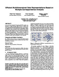
Corporatr-Headquarter
P-Value
(b)
Id-Corporate
Geometry
1
Name Geometry
#p
1 P2(pv2,r1)
P3
Name Geometry r
Name Geometry r
Name Geometry r
P4(pv1,r2)
P5
P6
Name Geometry r
Name Geometry r
Name Geometry r
P7(pv1,r3)
P8
P9
Geometric representation object identifier Geometric attribute
(a)
1
P1(pv1,r1)
Perception value Spatial data type icon
Industrial_Accident
(c)
Geometry
1
Name Geometry r
Legend:
Name Geometry r
Name Geometry r
AF(pv1) = NN AF(pv2) = DGU AF(pv3) = TGU
Id-Dimension 1 … Id-Dimension n Number of deaths Number of injuries #p
/AFs
1
1
P1(pv1,r1)
P2(pv2,r1)
P3
Name Geometry
Name Geometry
Name Geometry
Composition Association between SL-MGR and Geometric Representations Structure Spatial data type icons of GRS
Fig. 1. (a) Geometric Representations Structure, (b) Spatial level supporting MGR, (c) Spatial measure supporting MGR
In order to represent graphically a SL-MGR, we propose the notation depicted in Figure 1.b. In our notation, the GRSs which are stamped at different resolutions by the same point of view are grouped to form a cluster (that we call cluster of geometric granularities) and are ordered from the most detailed resolution to the coarsest resolution within that cluster (r1 is the coarsest resolution, r3 is the most detailed). When switching from one resolution to a coarser resolution, the new geometry associated to a given spatial object could either be stored beforehand or obtained by applying some map generalization operators17. The application of these operators must not result in the elimination of geometric objects, particularly when these objects are important for the decision-making process and/or explicitly requested to be displayed on the final map. Moreover, on the one hand, each cluster of geometric granularities generates a set of multi-resolution geometric representations associated to a given spatial object. On the other hand, the GRS stamped by the same resolution and associated to different points of views generates a set of single-resolution geometric representations related to a given spatial object. Definition 2: Spatial hierarchy supporting Multiple Geometric Representations A spatial hierarchy is said to be geometric if all its levels are geometric spatial levels. Similarly, this hierarchy is said to be Spatial Hierarchy supporting Multiple Geometric Representations (SH-MGR) if all its geometric spatial levels are also supporting multiple geometric representations (i.e., they are SL-MGR). Definition 3: Spatial Dimension supporting Multiple Geometric Representations As already mentioned, a spatial dimension is a dimension that includes at least one spatial hierarchy18.This dimension is said to be geometric if it includes at least one geometric spatial hierarchy. In the same way, the dimension is said to be Spatial Dimension supporting Multiple Geometric Representations (SD-MGR) if it includes at least one spatial hierarchy supporting multiple geometric representations (i.e., a SH-MGR). Definition 4: Spatial Measure supporting Multiple Geometric Representations Like in some existing works5,11, we model a spatial measure as a spatial attribute of a fact in the SDW. A geometric spatial measure is defined as a spatial measure that is represented by a geometric spatial attribute15.This measure is said to be Spatial Measure supporting Multiple Geometric Representations (SM-MGR) if it can be assigned as many geometries as perceptions. Furthermore, as recommended in previous works5,19, spatial aggregation functions must be defined when SM-MGR are used. Examples of such functions include Nearest-Neighbor (NN), Disjoint Geometric Union (DGU), and Touches Geometric Union (TGU). We reflect these functions in Figure 1.c for the SM-MGR geometry. To this end, as an example, we specify: (i) NN as an aggregation function for the set of perceptions {P1 (pv1,r1), P4 (pv1,r2), P7 (pv1,r3)}of the same point of view pv1; (ii) DGU as an aggregation function for the set of perceptions {P2 (pv2,r1), P5 (pv2,r2), P8 (pv2,r3)} of the same point of view pv2; and (iii) TGU as an aggregation function for the set of perceptions {P3 (pv3,r1), P6 (pv3,r2), P9 (pv3,r3)} of the same point of view pv3. In Figure 1.c, AF(pvi) refers to a spatial aggregation function of SM-MGR associated to point of view pvi. For simplification purposes we don't illustrate the whole clusters in Figure 1.c.
569
570
Boubaker Boulekrouche et al. / Procedia Computer Science 56 (2015) 566 – 572
2.3. Motivating Scenario Wilaya
Industrial_Zone
Id-Corporate
Geometry #p
1
1
1
1
Corporatr-Headquarter
Id-Zone Other attributes
Id-Corporate Other attributes
Geometry #p
Geometry #p
1
1
1
1
1
(pv1,*)
(pv2,*)
(pv3,*)
(pv1,*)
(pv2,*)
(pv3,*)
(pv1,*)
(pv2,*)
(pv3,*)
Name Geometry
Name Geometry
Name Geometry
Name Geometry
Name Geometry
Name Geometry
Name Geometry
Name Geometry
Name Geometry
Industrial_Accident
Type
All-Type
Id-Dimension 1 ……. Id-Dimension n
Id-T ype Others
1
1
1
(pv1,*)
(pv2,*)
(pv3,*)
Name Geometry
Name Geometry
Name Geometry
Number of deaths Number of injuries
Geometry
Cause Month month
#p
Id-C ause Others
All_Causes Year Year
Fig. 2. Representing the motivating scenario of industrial accidents in Algeria
Several decision-makers (stakeholders) in Algeria are currently collaborating in the management of industrial accidents in the different cities of the country. Each of these stakeholders, including industrial risk experts, civil protection managers, and public safety officers, has its own specific risk evaluation, perception, and map-based geometric representation. These differences commonly increase the complexity of risk analysis and make collaboration almost impossible. There is therefore an urgent need for an efficient supporting tool where MGR can be stored and generated on-the-fly or on-demand for each stakeholder. We argue that instead of using several SDWs, a single SDW-based application using the same schema and the same statistical data (thematic) - but supporting MGR related to risk localization - would allow the different stakeholders to explore spatial data simultaneously, according to multiple perceptions. This will consequently boost their collaboration and leverage the tedious and complex data analysis and decision-making processes. Our aim is thus to provide stakeholders with a system for spatial multidimensional analysis of data on industrial risks. This system should allow for the analysis of the numbers of deaths, number of injuries depending on the type of risk, the cause of accidents, and the geographical location and time of accidents. We depict in Figure 2 a possible design of the SDW supporting MGR for the scenario of monitoring of industrial accidents. 3. Implementation For the sake of illustration, we developed a SDSS called GéOLAP to provide on-the-fly personalized geo-decisional information to different decision-makers according to their preferences and to the visualization characteristics of their terminals (desktop, PDA, mobile phone, etc.). GéOLAP system was implemented using ROLAP server Mondrian and the PostGIS spatial DBMS for the processing and analysis of non-spatial and spatial data respectively. We used a star schema to model our SDW. Figure 3.a shows our relational data model used in the implementation. The fact table used is Industrial_accidents. It includes four foreign keys to the dimensions reflecting the cause of the accident, its type, the zone where it occurred, and the time when it occurred. It also includes two measures nbdeaths and nbinjuries as well as the SM-MGR localization. In our relational model, we propose to associate each spatial level of a given spatial dimension to a new table (representation table) that represents the structure holding multiple geometric representations. Each of these representation tables (e.g., Local_Rep in Figure 3.a) contains fields to represent its primary key (e.g., Local_repPK in Figure 3.a), a foreign key from a geometric table (e.g., LocGeoFK in Figure 3.a) and a perception attribute. Each geometric table contains fields to represent its primary key as well as to store its geometrical representation (Geometry). It is important to remark that without the geometric table, a spatial dimension with spatial data would have to store all multiple geometries together, which will not be cost-effective in terms of storage space.
571
Boubaker Boulekrouche et al. / Procedia Computer Science 56 (2015) 566 – 572
Corp-Geo
Local_Rep
Time
CorGeoFK Geometry
Local_repPK LocGeoFK Perception
id-Month Month Year
Industrial_Accidents
(a)
Id-Zone Id-time Id-Cause Id-Type
Type id-Type Type
nbdeaths nbinjuries Localization
Cause id-Cause Cause
Zone id-Zone Corporate Corp_repFK Indu_zone Indu_repFK Wilaya Wil_repFK
Loc_geo LocGeoPK Geometry
Indu_Rep Indu_repPK IndGeoFK Perception
Wilaya_Rep Wil_repPK WilGeoFK Perception
Indu_Geo
Wilaya-Geo
IndGeoFK Geometry
WilGeoFK Geometry