MACHINE LEARNING IN REMOTE SENSING DATA PROCESSING Gustavo Camps-Valls Image Processing Laboratory (IPL), Universitat de Val`encia, Spain Catedr´atico A. Escardino - 46980 Paterna, Val`encia, Spain
[email protected], http://www.uv.es/gcamps ABSTRACT
Remote sensing data processing deals with real-life applications with great societal values. For instance urban monitoring, fire detection or flood prediction from remotely sensed multispectral or radar images have a great impact on economical and environmental issues. To treat efficiently the acquired data and provide accurate products, remote sensing has evolved into a multidisciplinary field, where machine learning and signal processing algorithms play an important role nowadays. This paper serves as a survey of methods and applications, and reviews the latest methodological advances in machine learning for remote sensing data analysis.
O
1. INTRODUCTION Remote sensing is the field of science studying and modeling the processes occurring on the Earth’s surface and their interaction with the atmosphere [1]. Earth observation at local and global scales is nowadays an increasing need. By monitoring urban growth, estimating temperature or ocean salinity, and identifying objects on the surface, remote sensing provides valuable information for policy and decision makers, as well as for tourism or defense applications. These objectives are possible because materials in a scene reflect, absorb, and emit electromagnetic radiation in a different way depending of their molecular composition and shape. Remote sensing exploits this physical fact and deals with the acquisition of information about a scene (or specific object) at a short, medium or long distance. According to the type of energy resources involved in the data acquisition, remote sensing imaging instruments can be passive or active. In this paper we will focus on passive sensors which have experienced a great evolution in the last decades, and pose challenging problems for the machine learning and signal processing communities. Passive systems exploit solar radiation to capture the emergent radiation, which is acquired by an airborne or satellite spectrometer at different wavelengths. The acquired signal or spectral signature is This work was partially supported by projects from the Spanish Ministry of Science TEC2006-13845/TCM, CSD2007-00018 and AYA2008-05965C04-03.
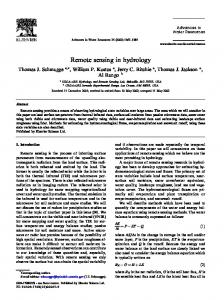
Fig. 1. Principle of imaging spectroscopy.
known as spectrum and is used to identify materials in the scene. Figure 1 shows the principle of imaging spectroscopy to perform satellite remote sensing. The resulting multispectral image consists of a simultaneous acquisition of spatially coregistered images, in several, spectrally contiguous bands from a remotely operated platform [1, 2]. The diversity of objectives and the special characteristics of the data give rise to the use of a wide range of machine learning and signal processing algorithms. The statistical characterization of remote sensing images turns to be difficult because of pixel’s high dimensionality, presence of different kinds of noise sources and uncertainty, their inherent non-linear nature, and the high spatial and spectral redundancy. Machine learning has been successfully applied in remote sensing for classification, regression, clustering, coding, or source separation. However, we feel that promising new learning paradigms, such as transfer, active, structured, reinforcement, semisupervised or manifold learning, have been payed little or no attention. This paper reviews both traditional and new trends in machine learning for remote sensing data processing with the main goal of estimulating research and development in both directions.
2. TRADITIONAL MACHINE LEARNING FOR REMOTE SENSING
Classification maps are the main product of remote sensing image processing. In the last years, data-driven approaches have gained relevance in the remote sensing community. In particular, non-parametric methods have demonstrated good performance. Supervised and unsupervised are revised here.
of images and the interest in monitoring Earth’s changes at local and global scales. On the one hand, many multi-temporal supervised methods have been used during the last years, such as evidence reasoning [31], generalized least squares [32], neural networks [33] or support vector machines (SVMs) [34, 35]. Hidden Markov random fields [36] and fuzzy-based approaches [37] have been also used to link time-varying statistics. On the other hand, change detection approaches typically use image subtraction or ratioing, change vector analysis, or cross-correlation analysis [1]. Recently, neural networks [38] and kernel methods [9] have been used. Composite kernels have been specifically designed for the combination of multitemporal, multisensor and multisource information [9, 39]. Recent advances focus on the reduction of the user intervention, either by using semi- or unsupervised methods [40, 41].
2.1.1. Supervised Image Classification
2.2. Feature Selection and Extraction
These methods use labeled information about class membership of single pixels (labeled by expert users) to build a model able to generalize to the whole image (or set of images). At present, the most successful methods are neural networks [3, 4] and support vector machines [5]. The latter have been applied to both multispectral [6,7] and hyperspectral [5,8,9] data in a wide range of domains, including object recognition [10], landcover and multi-temporal classification [9,11,12], and urban monitoring [13] to name a few. Another field of growing interest is that of classifier ensembles [14, 15] and boosting methods [16].
A critical issue when working with high dimensional datasets, such as hyperspectral images, is that the computational time is increased and the high collinearity and presence of noisy bands can degrade the quality of the model. But maybe more important is the study of the relative relevance of the acquired bands to perform a given task. Remember that spectral bands have a physical meaning and can be related to the properties of the elements to be identified or modeled. Feature selection has been studied in remote sensing under classical discriminative criteria [42]. Lately, advanced machine learning methods have been used, such as genetic algorithms [43], or SVM-based recursive feature elimination [44]. Recently more attention has been focused on feature extraction methods. Even though the use of linear methods such as PCA or PLS is quite common, recent advances to cope with nonlinearities in the data based on multivariate kernel machines have been presented [45].
In this section, we review the traditional machine learning approaches to remote sensing applications. Only the most relevant applications are revised: classification, feature selection and extraction, regression and unmixing. 2.1. Image classification
2.1.2. Unsupervised Image Classification Unsupervised classification of remote sensing images is a critical problem in many applications, either for visualization and monitoring of similar areas in the scene or as a pre-processing step for supervised classifiers. Many clustering methods have been designed, such as rule-based [17], neural networks [18– 20], or based on SVMs [21]. Three approaches dominate the field. First, fuzzy clustering has been used alone [22, 23] or combined with multiobjective optimization [24] for exploiting spatially membership relations. Second, fusion of multisource information has been conducted either with graphcuts [25], projection pursuit [26], hierarchical clustering [27], or Markov random fields [28] for contextual regularization. Also, multicomponent image segmentation with self-organizing maps (SOM) and hybrid genetic algorithms [20] have been proposed. Finally, it is worth mentioning the use of dynamic clustering strategies for spatio-temporal reasoning [29] and visualization [30]. 2.1.3. Multitemporal Classification and Change Detection Multitemporal and change detection problems are very active because of the increasing availability of complete time series
2.3. Signal Unmixing Pixels are invariably a mixture of the signatures of the various materials found within the spatial extent of the ground instantaneous field view. An important problem in remote sensing is the development of automatic extraction methods of the spectral pure pixels (known as endmembers) directly from the image. These pure pixels are the basis to express all pixels as a linear (or non-linear) combination of them, and this, in turn, allows subpixel detection [2] or mineral mapping [46]. Some classical techniques for this purpose include the N-FINDR algorithm [47], the vertex component algorithm (VCA) in [48], and an orthogonal subspace projection (OSP) technique in [49], among others [50]. Selection of the free parameters and inclusion of spatial information in the unmixing process are key issues nowadays [51]. Recently support vector domain description (SVDD) has been also used to select the pure pixels [45].
2.4. Regression and Model Inversion Robust, fast and accurate regression tools are a critical demand in remote sensing. The estimation of biophysical parameters is of special relevance in order to better understand the environment dynamics at local and global scales [1]. The inversion of analytical models introduces a higher level of complexity, induces an important computational burden, and sensitivity to noise becomes an important issue. In the recent years, nevertheless, the use of empirical models adjusted to learn the relationship between the acquired spectra and actual ground measurements has become very attractive. Parametric models have some important drawbacks, which typically lead to poor prediction results on unseen (test) data. As a consequence, non-parametric and potentially non-linear regression techniques have been effectively introduced, such as neural networks [52, 53], support vector regression (SVR) [54, 55], relevance vector machines (RVM) [56], or Gaussian Processes (GP) [57]. Even been more accurate than analytical models, they lack interpretability and rely on training data from the observed scene, which limits its extensive use. 3. NEW TRENDS IN MACHINE LEARNING FOR REMOTE SENSING The special characteristics of the acquired data motivates the continuous research in machine learning methods for tackling particular remote sensing problems. In this section, we summarize some promising machine learning paradigms of recent application in remote sensing.
(typically few) labeled data and the wealth of unlabeled samples to model the manifold data structure. In remote sensing, several methods have been developed, either generative or discriminative. The estimation of the conditional density to be included in generative models have been extensively exploited [64]. Recently, many graph-based methods have been developed for classification [61, 65], regression [55], and target detection [66, 67]. Also, the design of cluster and bagged kernels have been successfully presented [68]. Also the transductive SVM has been applied for image classification [69, 70] and change detection [40]. In [71], a semisupervised kernel Fisher discriminant classifier was proposed. These methods, however, cannot readily applicable to large scale problems with millions of unlabeled samples, as is often the case. 3.3. Transfer Learning A common problem in remote sensing is that of updating land-cover maps by classifying temporal series of images when only training samples collected at one time are available. This is known as transfer learning or domain adaptation. The problem was initially tackled with partially unsupervised classifiers, under parametric formalisms [72] and neural networks [73]. The approach was then successfully extended to domain adaptation SVM (DASVM) [74]. A related problem is also that of classifying an image with samples from different images, which induces the sample selection bias or covariance shift problems. These problems have been recently presented by defining proper kernel machines [75]. 3.4. Active Learning
3.1. Manifold Learning Recently the field of manifold learning has appeared as a powerful framework to analyze nonlinearities in the data. The field is related to that of dimensionality reduction and nonlinear feature extraction, which is scattered throughout computer science, machine learning, image processing and cybernetics. The main goal in manifold learning is to map high dimensional data into a lower dimension while preserving the main features of the original data for better analysis. In this way, visualization and understanding of high-dimensional data becomes feasible. Traditional linear dimensionality reduction methods fail in describing the inherent structure of remote sensing data. Consequently some preliminary works using nonlinear transforms have been presented, such as Isomap [58, 59], Laplacian methods [60, 61] or Local Linear Embedding [59, 62]. Besides, some algorithms that analyze the intrinsic dimensionality of hyperspectral images can be mentioned [63]. 3.2. Semi-supervised Learning A related field to manifold learning is semi-supervised learning, which is concerned in developing models that exploit the
In remote sensing, application of active learning methods that select the most relevant samples for training is quite recent. A SVM method for object-oriented classification was proposed in [76], while maximum likelihood classifiers for pixelbased classification was presented in [77]. Recently, this approach was extended in [78] by proposing boosting to iteratively weight the selected pixels. In [79, 80] informationbased active learning was proposed for target detection, and in [81], a model-independent active learning method was proposed for very-high resolution satellite images. 3.5. Structured Learning Most of the techniques revised so far assume a simple set of outputs Y, for instance binary labels Y = {−1, 1}. However, more complex output spaces can be imagined, e.g. predicting multiple labels (land use and land cover simultaneously), multi-temporal image sequences, or abundance fractions. Such complex output spaces are the topic of structured learning, one of the most recent developments in machine learning. Only a computer vision application [82] and the preliminary results in [83] have been presented for image processing.
4. CONCLUSIONS The field that machine learning occupies in remote sensing has been summarized in this paper. Attention has been paid not only to the standard machine learning paradigms (classification, regression and feature extraction/selection), but also to recently and promising ones, such as manifold, semisupervised, active, transfer and structured learning. The special peculiarities of the images open the field for research and development of new methods. And viceversa, the new learning paradigms available offer new ways of looking at old, yet unsolved, problems. 5. ACKNOWLEDGMENTS The author would like to thank Mr. Devis Tuia from the University of Lausanne (Switzerland) for his valuable pieces of advice and useful discussion and comments about this work. 6. REFERENCES [1] T. M. Lillesand, R. W. Kiefer, and J. Chipman, Rem. Sens. and Image Interpretation, J. Wiley & Sons, NY, 2008. [2] G. Shaw and D. Manolakis, “Signal processing for hyperspectral image exploitation,” IEEE Signal Processing Magazine, vol. 50, 12–16, Jan 2002. [3] J.A. Benediktsson, J. A. Palmason, and J. R. Sveinsson, “Classification of hyperspectral data from urban areas based on extended morphological profiles,” IEEE Trans. Geosci. Remote Sens., vol. 43, 480–490, 2005. [4] F. Del Frate, F. Pacifici, G. Schiavon, and D. Solimini, “Use of neural networks for automatic classification from highresolution images,” IEEE Trans. Geosci. Remote Sens., vol. 45 (4), 800–809, 2007. [5] G. Camps-Valls and L. Bruzzone, “Kernel-based methods for hyperspectral image classification,” IEEE Trans. Geosci. Remote Sens., vol. 43, 1351–1362, 2005.
[10] J. Inglada, “Automatic recognition of man-made objects in high resolution optical remote sensing images by SVM classification of geometric image features,” ISPRS J. Photogramm. Rem. Sens., vol. 62, 236–248, 2007. [11] G. Camps-Valls, L. Gomez-Chova, J. Mu˜noz Mar´ı, J. VilaFranc´es, and J. Calpe-Maravilla, “Composite kernels for hyperspectral image classification,” IEEE Geosci. Remote Sens. Lett., vol. 3, 93–97, 2006. [12] M. Chi, R. Feng, and L. Bruzzone, “Classification of hyperspectral remote-sensing data with primal SVM for small-sized training dataset problem,” Adv. Space Res., vol. 41 (11), 1793– 1799, 2008. [13] M. Fauvel, J. A. Benediktsson, J. Chanussot, and J. R. Sveinsson, “Spectral and spatial classification of hyperspectral data using SVMs and morphological profiles,” IEEE Trans. Geosci. Remote Sens., vol. 46 (11), 3804 – 3814, 2008. [14] G. J. Briem, J. A. Benediktsson, and J. R. Sveinsson, “Multiple classifiers applied to multisource remote sensing data,” IEEE Trans. Geosc. Rem. Sens., vol. 40, no. 10, 2291–2299, 2002. [15] J. Ham, Y. C. Chen, M. M. Crawford, and J. Ghosh, “Investigation of the random forest framework for classification of hyperspectral data,” IEEE Trans. Geosc. Rem. Sens., vol. 43, no. 3, 492–501, 2005. [16] G. Camps-Valls and A. Rodrigo-Gonz´alez, “Classification of satellite images with regularized AdaBoosting of RBF neural networks,” in Speech, Audio, Image and Biomedical Signal Processing using Neural Networks, Bhanu Prasad and S. R. Mahadeva Prasanna, Eds., pp. 309–326. Springer-Verlag, Germany, 2008. [17] A. Baraldi, V. Puzzolo, P. Blonda, L. Bruzzone, and C. Tarantino, “Automatic spectral rule-based preliminary mapping of calibrated landsat TM and ETM+ images,” IEEE Trans. Geosc. Rem. Sens., vol. 44, no. 9, 2563–2586, Sept. 2006. [18] Yanfei Zhong, Liangpei Zhang, Bo Huang, and Pingxiang Li, “An unsupervised artificial immune classifier for multi/hyperspectral remote sensing imagery,” IEEE Trans. Geosc. Rem. Sens., vol. 44, no. 2, 420–431, Feb. 2006.
[6] C. Huang, L.S. Davis, and J.R.G. Townshend, “An assessment of support vector machines for land cover classification,” Int. J. Remote Sens., vol. 23:4, 725–749, 2002.
[19] A. Baraldi and F. Parmiggiani, “A neural network for unsupervised categorization of multivalued input patterns: an application to satellite image clustering,” IEEE Trans. Geosc. Rem. Sens., vol. 33, no. 2, 305–316, 1995.
[7] G. M. Foody and A. Mathur, “Toward intelligent training of supervised image classifications: directing training data acquisition for SVM classification,” Remote Sens. Environ., vol. 93, 107–117, 2004.
[20] M. Awad, K. Chehdi, and A. Nasri, “Multicomponent image segmentation using a genetic algorithm and artificial neural network,” IEEE Geosc. Rem. Sens. Lett., vol. 4, no. 4, pp. 571–575, Oct. 2007.
[8] M. Fauvel, J. Chanussot, and J. A. Benediktsson, “Evaluation of kernels for multiclass classification of hyperspectral remote sensing data,” in IEEE ICASSP - International conference on Acoustics, Speech and Signal Processing, Toulouse, France, 2006, II–813–II–816.
[21] A. Mukhopadhyay and U. Maulik, “Unsupervised pixel classification in satellite imagery using multiobjective fuzzy clustering combined with SVM classifier,” IEEE Trans. Geosc. Rem. Sens., vol. 47, no. 4, 1132–1138, April 2009.
[9] G. Camps-Valls, L. G´omez-Chova, J. Mu noz Mar´ı, J. L. Rojo´ Alvarez, and M. Mart´ınez-Ram´on, “Kernel-based framework for multi-temporal and multi-source remote sensing data classification and change detection,” IEEE Trans. Geosci. Remote Sens., vol. 46 (6), pp. 1822–1835, 2008.
[22] G. Bilgin, S. Erturk, and T. Yildirim, “Unsupervised classification of hyperspectral-image data using fuzzy approaches that spatially exploit membership relations,” IEEE Geosc. Rem. Sens. Lett., vol. 5, no. 4, pp. 673–677, Oct. 2008. [23] R.L. Cannon, J.V. Dave, J.C. Bezdek, and M.M. Trivedi, “Segmentation of a thematic mapper image using the fuzzy c-means
clustering algorithm,” IEEE Trans. Geosc. Rem. Sens., vol. GE-24, no. 3, 400–408, 1986. [24] S. Bandyopadhyay, U. Maulik, and A. Mukhopadhyay, “Multiobjective genetic clustering for pixel classification in remote sensing imagery,” IEEE Trans. Geosc. Rem. Sens., vol. 45, no. 5, 1506–1511, 2007. [25] M. Tyagi, F. Bovolo, A.K. Mehra, S. Chaudhuri, and L. Bruzzone, “A context-sensitive clustering technique based on graph-cut initialization and expectation-maximization algorithm,” IEEE Geosc. Rem. Sens. Lett., vol. 5, no. 1, pp. 21–25, 2008.
[38] L. Bruzzone, R. Cossu, and G. Vernazza, “Detection of landcover transitions by combining multidate classifiers,” Pattern Recognition for Remote Sensing (PRRS 2002), vol. 25(13), 1491–1500, 2004. [39] D. Tuia, F. Ratle, A. Pozdnoukhov, and G. Camps-Valls, “Multi-source composite kernels for urban image classification,” IEEE Geosc. Rem. Sens. Lett., 2008, Accepted. [40] F. Bovolo, L. Bruzzone, and M. Marconcini, “A novel approach to unsupervised change detection based on a semisupervised SVM and a similarity measure,” IEEE Trans. Geosc. Rem. Sens., vol. 46(7), 2070–2082, 2008.
[26] C.M. Bachmann, T.F. Donato, G.M. Lamela, W.J. Rhea, M.H. Bettenhausen, R.A. Fusina, K.R. Du Bois, J.H. Porter, and B.R. Truitt, “Automatic classification of land cover on smith island, va, using hymap imagery,” IEEE Trans. Geosc. Rem. Sens., vol. 40, no. 10, 2313–2330, Oct 2002.
[41] S. Ghosh, L. Bruzzone, S. Patra, F. Bovolo, and A. Ghosh, “A novel context-sensitive technique for unsupervised change detection based on hopfield type neural networks,” IEEE Trans. Geosc. Rem. Sens., vol. 45(3), 778–789, 2007.
[27] A.R.S. Marcal and L. Castro, “Hierarchical clustering of multispectral images using combined spectral and spatial criteria,” IEEE Geosc. Rem. Sens. Lett., vol. 2, no. 1, pp. 59–63, 2005.
[42] L. Bruzzone and S.B. Serpico, “A technique for features selection in multiclass problems,” Int. J. Rem. Sens., vol. 21 (3), 549–563, 2000.
[28] A. Sarkar, M.K. Biswas, B. Kartikeyan, V. Kumar, K.L. Majumder, and D.K. Pal, “A MRF model-based segmentation approach to classification for multispectral imagery,” IEEE Trans. Geosc. Rem. Sens., vol. 40, no. 5, 1102–1113, 2002.
[43] M. Pal, “Support vector machine-based feature selection for land cover classification: a case study with DAIS hyperspectral data,” Int. J. Rem. Sens., vol. 27 (14), 2877–2894, 2006.
[29] P. Heas and M. Datcu, “Modeling trajectory of dynamic clusters in image time-series for spatio-temporal reasoning,” IEEE Trans. Geosc. Rem. Sens., vol. 43, no. 7, 1635–1647, 2005. [30] Xiuping Jia and J.A. Richards, “Cluster-space representation for hyperspectral data classification,” IEEE Trans. Geosc. Rem. Sens., vol. 40, no. 3, 593–598, 2002. [31] F. Wang, “A knowledge-based vision system for detecting land changes at urban fringes,” IEEE Trans. Geosc. Rem. Sens., vol. 31, no. 1, 136–145, 1993. [32] J. T. Morisette and S. Khorram, “An introduction to using generalized linear models to enhance satellite-based change detection,” in Proceedings of the International Conference on Geoscience and Remote Sensing, 1997, 1282–1284. [33] D. Kushardono, K. Fukue, H. Shimoda, and T. Sakata, “Comparison of multi-temporal image classification methods,” in Proceedings of the International Conference on Geoscience and Remote Sensing, 1995, 1282–1284. [34] J. Li and R. M. Narayanan, “A shape-based approach to change detection of lakes using time series remote sensing images,” IEEE Trans. Geosc. Rem. Sens., vol. 41, no. 11, 2466–2477, 2003. [35] D. Liu, M. Kelly, and P. Gong, “Classifying multi-temporal Landsat TM imagery using Markov random fields and support vector machines,” in 3rd International Workshop on the Analysis of Multi-temporal Remote Sensing Images, 2005. [36] F. Melgani and S. B. Serpico, “A Markov random field approach to spatiotemporal contextual image classification,” IEEE Trans. Geosci. Remote Sens., vol. 41, no. 11, pp. 2478– 2487, 2003. [37] F. Melgani, “Classification of multitemporal remote-sensing images by a fuzzy fusion of spectral and spatio-temporal contextual information,” Intl. Journal of Pattern Recognition and Artificial Intelligence, vol. 18, no. 2, 143–156, 2004.
[44] R. Archibald and G. Fann, “Feature selection and classification of hyperspectral images with support vector machines,” IEEE Geosc. and Rem. Sens. Lett., vol. 4 (4), 674–679, 2007. [45] G. Camps-Valls and L. Bruzzone, Kernel Methods for Remote Sensing Data Analysis, J. Wiley & Sons, 2009. [46] N. Keshava and J. F. Mustard, “Spectral unmixing,” IEEE Signal Processing Magazine, vol. 19, no. 1, 44–57, 2002. [47] M. E. Winter, “N-FINDR: an algorithm for fast autonomous spectral end-member determination in hyperspectral data,” Proc. SPIE Im. Spectr. V, vol. 3753, 266–277, 2003. [48] J. M. P. Nascimento and J. M. Bioucas-Dias, “Vertex Component Analysis: A Fast Algorithm to Unmix Hyperspectral Data,” IEEE Trans. Geosc. Rem. Sens., vol. 43, no. 4, 898– 910, 2005. [49] J. C. Harsanyi and C.-I Chang, “Hyperspectral image classification and dimensionality reduction: An orthogonal subspace projection,” IEEE Trans. Geosc. Rem. Sens., vol. 32, no. 4, 779–785, 1994. [50] A. Plaza, P. Martinez, R. Perez, and J. Plaza, “A quantitative and comparative analysis of endmember extraction algorithms from hyperspectral data,” IEEE Trans. Geosc. Rem. Sens., vol. 42, no. 3, 650–663, 2004. [51] A. Plaza and C.-I Chang, “Impact of initialization on design of endmember extraction algorithms,” IEEE Trans. Geosc. Rem. Sens., vol. 44, no. 11, 3397–3407, 2006. [52] P. Cipollini, G. Corsini, M. Diani, and R. Grass, “Retrieval of sea water optically active parameters from hyperspectral data by means of generalized radial basis function neural networks,” IEEE Trans. On Geosc. Rem. Sens., vol. 39, 1508–1524, 2001. [53] B. Dzwonkowski and X.-H. Yan, “Development and application of a neural network based colour algorithm in coastal waters,” Intl. J. Rem. Sens., vol. 26, no. 6, 1175–1200, 2005.
´ [54] G. Camps-Valls, L. Bruzzone, J.L. Rojo-Alvarez, and F. Melgani, “Robust support vector regression for biophysical parameter estimation from remotely sensed images,” IEEE Geosc. Rem. Sens. Lett., vol. 3, no. 3, 339–343, 2006.
[69] L. Bruzzone, M. Chi, and M. Marconcini, “A novel transductive SVM for semisupervised classification of remote sensing images,” IEEE Trans. Geosci. Remote Sens., vol. 44 (11), pp. 3363–3373, 2006.
[55] G. Camps-Valls, J. Mu˜noz-Mar´ı, L. G´omez-Chova, K. Richter, and J. Calpe-Maravilla, “Biophysical parameter estimation with a semi-supervised support vector machine,” IEEE Geosc. Rem. Sens. Lett., 2009, Accepted.
[70] M. Chi and L. Bruzzone, “Semi-supervised classification of hyperspectral images by SVMs optimized in the primal,” IEEE Trans. Geosc. Rem. Sens., vol. 45(4), 1870–1880, 2007.
[56] G. Camps-Valls, L. Gomez-Chova, J. Vila-Franc´es, J. Amor´osL´opez, J. Mu˜noz-Mar´ı, and J. Calpe-Maravilla, “Retrieval of oceanic chlorophyll concentration with relevance vector machines,” Rem. Sens. Envir., vol. 105, no. 1, 23–33, Nov 2006. [57] L. Pasolli, F. Melgani, and E. Blanzieri, “Estimating biophysical parameters from remotely sensed imagery with Gaussian Processes,” in IEEE International Geoscience and Remote Sensing Symposium, IGARSS’08, Boston, USA, 2008. [58] C.M. Bachman, T.L. Ainsworth, and R.A. Fusina, “Exploiting manifold geometry in hyperspectral imagery,” IEEE Trans. Geosci. Remote Sens., vol. 43 (3), 441–454, 2005. [59] C.M. Bachman, T.L. Ainsworth, and R.A. Fusina, “Improved manifold coordinate representations of large-scale hyperspectral scenes,” IEEE Trans. Geosci. Remote Sens., vol. 44 (10), pp. 2786–2803, 2006. [60] W. Kim, M. Crawford, J. Tilton, and J. Ghosh, “Spatially adapted manifold learning for classification of hyperspectral imagery with insufficient labeled data,” in IEEE Geosc. Rem. Sens. Symp. IGARSS, 2008. [61] L. G´omez-Chova, G. Camps-Valls, J. Mu˜noz Mar´ı, and J. Calpe, “Semi-supervised image classification with Laplacian support vector machines,” IEEE Geosc. Rem. Sens. Lett., vol. 5, pp. 336–340, 2008. [62] T. Han and D. Goodenough, “Nonlinear feature extraction of hyperspectral data based on locally linear embedding (LLE),” in IEEE Geosc. Rem. Sens. Symp. IGARSS, 2005. [63] C.-I Chang and Q. Du, “Estimation of number of spectrally distinct signal sources in hyperspectral imagery,” IEEE Trans. Geosc. Rem. Sens., vol. 42, no. 3, 608–619, 2004. [64] Q. Jackson and D.A. Landgrebe, “An adaptive classifier design for high-dimensional data analysis with a limited training data set,” IEEE Trans. Geosc. Rem. Sens., pp. 2664–2679, Dec. 2001. [65] G. Camps-Valls, T. Bandos, and D. Zhou, “Semi-supervised graph-based hyperspectral image classification,” IEEE Trans. Geosc. Rem. Sens., vol. 45, no. 10, 3044–3054, Oct 2007. [66] J. Mu˜noz-Mar´ı, L. G´omez-Chova, G. Camps-Valls, and J. J. Calpe-Maravilla, “Image classification with semisupervised one-class support vector machine,” in SPIE Remote Sensing Conference, Cardiff, Wales, UK, Sep 2008. [67] L. Capobianco and G. Camps-Valls, “Hyperspectral target detection with a semi-supervised kernel orthogonal subspace projection,” IEEE Trans. Geosc. Rem. Sens., 2009, Accepted. [68] D. Tuia and G. Camps-Valls, “Semi-supervised remote sensing image classification with cluster kernels,” IEEE Geosci. Remote Sens. Lett., vol. 6 (1), 224–228, 2009.
[71] M. Dundar and A. Langrebe, “A cost-effective semisupervised classifier approach with kernels,” IEEE Trans. Geosci. Remote Sens., vol. 42, no. 1, pp. 264–270, 2004. [72] L. Bruzzone and D.F. Prieto, “Unsupervised retraining of a maximum likelihood classifier for the analysis of multitemporal remote sensing images,” IEEE Trans. Geosc. Rem. Sens., vol. 39, no. 2, 456–460, Feb 2001. [73] L. Bruzzone and R. Cossu, “A multiple-cascade-classifier system for a robust and partially unsupervised updating of landcover maps,” IEEE Trans. Geosc. Rem. Sens., vol. 40, no. 9, 1984–1996, Sep 2002. [74] L. Bruzzone and M. Marconcini, “Toward the automatic updating of land-cover maps by a domain-adaptation SVM classifier and a circular validation strategy,” IEEE Trans. Geosc. Rem. Sens., vol. 47, no. 4, 1108–1122, April 2009. [75] L. G´omez-Chova, G. Camps-Valls, L. Bruzzone, and J. CalpeMaravilla, “Semi-supervised remote sensing image classification based on clustering and the kernel mean map,” in IEEE International Geoscience and Remote Sensing Symposium, IGARSS’08, Boston, USA, 2008. [76] P. Mitra, B. Uma Shankar, and S.K. Pal, “Segmentation of multispectral remote sensing images using active support vector machines,” Pattern Recogn. Lett., vol. 25, 1067–1074, 2004. [77] S. Rajan, J. Ghosh, and M. M. Crawford, “An active learning approach to hyperspectral data classification,” IEEE Trans. Geosci. Remote Sens., vol. 46 (4), pp. 1231–1242, 2008. [78] G. Jun and J. Ghosh, “An efficient active learning algorithm with knowledge transfer for hyperspectral remote sensing data,” in IEEE Geosc. Rem. Sens. Symp. IGARSS, 2008. [79] C. Zhang, S. Franklin, and M.A. Wulder, “Geostatistical and texture analysis of airborne-acquired images used in forest classification,” Int. J. Remote Sens., vol. 25, 859–865, 2004. [80] Q. Liu, X. Liao, and L. Carin, “Detection of unexploded ordnance via efficient semisupervised and active learning,” IEEE Trans. Geosci. Remote Sens., vol. 46 (9), pp. 2558–2567, 2008. [81] D. Tuia, F. Ratle, F. Pacifici, M. Kanevski, and W.J. Emery, “Active learning methods for remote sensing image classification,” IEEE Trans. Geosci. Remote Sens., in press. [82] M.B. Blaschko and C.H. Lampert, “Learning to localize objects with structured output regression,” in Computer Vision: ECCV 2008., D. Forsyth, P. Torr, and A. Zisserman, Eds. 2008, 2–15, Springer. [83] D. Tuia, M. Kanevski, J Mu˜noz Mar´ı, and G. Camps-Valls, “Structured SVM for remote sensing image classification,” in IEEE Workshop Machine Learning and Signal Processing, MLSP09, Grenoble, France, 2009.