Mobile Lidar Mapping: Building the Next Generation of Outdoor Environment Models for AR Rob HARRAP1 Queen’s University GeoEngineering Center Kinsgton (ON), Canada
Sylvie DANIEL2 Laval University Department of Geomatics Quebec City (QC) – Canada
ABSTRACT
2
There are broad synergies between the ‘world’ requirements for outdoor augmented reality applications, especially augmented games situated in realistic worlds, and the core capabilities of geomatics tools and techniques. AR applications are fundamentally rooted in space; they require accurae 3D models of the world to be able to provide highly immersive and interactive experiences. New high resolution modeling techniques using LiDAR scanning support the creation of centimeter-accurate models of real world settings for use in augmented reality and situated games; the cost of such models can be leveraged by the many other applications of such models.
In the proposed position paper, we will lay out a general view of the relevance of high resolution mobile LiDAR mapping to AR development. Our perspective is that, although expensive to acquire and difficult to process, LiDAR data represents a key framework for future augmented reality applications that require centimeter level feature representation. This is especially true in the case of augmented reality games.
KEYWORDS: Spatial Databases and GIS, Modeling and Recovery of Physical Attributes, Computer-Aided Design (CAD). INDEX TERMS: H.2.8 [Database Management]: Databases Applications; I.2.10 [Artificial Intelligence]: Vision and Scenes Understanding; J.6 [Computer-Aided Engineering] 1
CONTEXT OF OUTDOOR MOBILE AUGMENTED REALITY
We have seen recently an emergence in the public domain of outdoor mobile augmented reality (AR) applications on a wide range of hardware platforms. Solutions like Layars (http://Layar.eu) or Wikitude (http://www.wkitude.org/) provide new platforms allowing users to browse the world. These applications put an information overlay on top of the camera view of a smartphone, bringing digital data of various sorts into play whenever the user is looking at or for something in the real world. The world augmentation in these applications is rather light, and interests to improve and enhance the user experience have already been expressed. Current developments are focusing on geotagging and authoring platforms. If buildings and open places are the general targets, interactions with items like doors, light poles, signage, and cultural assets that exist in a typical urban area, may be a real challenge. Augmentation of reality pushes the problems of having a physical and photorealistic model of a domain to the limit as the overlay process relies on accurate alignment between that model and the world. This augmented world model, or set of models, must exist at a variety of scales – corresponding to the scales at which the user navigates a region (blocks) down to the scales of fine-grained interactions (centimeters). Features must also have rich annotations that support a variety of interaction styles, search, discovery, and community annotation.
1 2
[email protected] [email protected]
HIGH RESOLUTION WORLD ACQUISITION
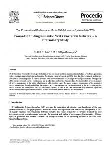
2.1 Mobile high resolution LiDAR Our concern in constructing outdoor mobile augmented reality has been the difficulty in collecting data at the scale of buildings and especially building components. Support for situated activity [1] as well as high resolution urban mapping demands models where features down to ‘doorknob scale’ are represented. Thus, the overwhelming problem to tackle is that of data acquisition at this level of detail. This exceeds the difficulty in fields such as game world building and computer animation where models must be precise (detailed and photorealistic) but not accurate (they don't match any real world setting precisely). As part of an ongoing research program on augmented reality, we are investigating the use of static and mobile LiDAR scanners to build geospatial data at unprecedented levels of accuracy. LiDAR scanners [2] rasterize a ranging laser over a target, generating a cloud of 3d locations at a density that can approach one point per square millimeter close to the scanner. LiDAR scanners rely on time of flight or phase change of the beam to determine ranging, and can deliver clouds that are accurate to a few centimeters out to hundreds of meters from the scanner. In the simplest case, the scanner is mounted on a tripod at a known location ('static' setup) and generates a cloud out to line-of-sight or maximum range, whichever is less. Scanning large areas with a tripod-mounted LiDAR is cumbersome. We have begun to investigate the use of mobile scanners to model outdoor environments. Mobile scanners, like the Terrapoint TITAN system (http://www.ambercore.com) we are using, generally consist of multiple LiDAR units integrated with GPS and inertial movement unit sensors as a single package that can be mounted on a truck body. They can scan at flow-oftraffic speeds, and with one pass can collect about 100 points per square meter, sufficient for building and building component modeling. The GPS and inertial movement unit work together to provide precise positioning during scanning; An example is shown in Figure 1. Note that this scene is perfectly recognizable as buildings and street infrastructure to a human viewer, but is in fact a very large collection of points in 3d. Objects are captured in their precise locations - including those not shown on national
mapping such as street furniture – effectively mapping the truly immersive 3D built environment. For areas where even higher detail is needed we have successfully merged data from static scanners to TITAN data resulting in localized models accurate to millimeters.
Figure 1. TITAN scan of a portion of downtown Kingston, Ontario, Canada. This data is in real world coordinates
2.2 Discussion LiDAR scanners generate very large clouds of point locations that can constrain geometric models of 3d features in dense environments such as streets, the interior of buildings, and furthermore can provide detailed reference models for 3d shapes of items such as large vehicles. However, there are a number of challenges facing widespread use of this approach, including completeness of the scan, processing of the cloud, and markup of the resulting model. First, the LiDAR and photograph collection process covers buildings based on orientation of the sensors and the presence of trees and other obstructions as can be clearly seen in Figure 1. The result is quite good when trees and other obstacles can be avoided, but may have gaps where these are close to building faces. There is abundant research on model gap-filling using procedural modeling, where the regularity of building features are used to estimate the content for gaps and so in cases where a procedural proxy is suitable and features are regular the effect of obscuring vegetation can be mitigated. Similar but typically more challenging issues arise when obscurance is due to buildings, where street access is impossible, or where law or policy prohibits the use of the scanner. Although there are gaps in the data as noted, geometric distortion is typically small since the mobile systems use sophisticated GPS and INS hardware to maintain position and pose accuracy. As a result, scanned objects show little distortion and even at significant driving speeds reproducible accuracy is on the order of 5cm, more than sufficient for highly detailed interactive feature modeling. There are also significant challenges in processing the resulting point clouds into CAD or GIS surface representations for use in AR. The primary difficulty with processing data of this type is the time taken to convert point clouds into features. This is at the moment labour intensive; however, compared to any other available method (e.g. photogrammetry, surveying, CAD recovery) known to produce similar detailed models of large areas it is highly efficient, accurate, and repeatable. Although the exact ratio is highly context-dependent, we have found that about thirty times as much on-computer processing time is needed as field time: behind every lidar field survey is an army of technicians
turning points into features and then into 3d world models with semantic annotations. Research work, relying on computer vision methods, is currently undertaken in order to help reducing the processing time by assisting with commonplace and repeating items such as light poles, curbs, and street furniture. In the long run, we may have systems that will be able to build a preliminary model during the scan acquisition. Note that processing of points to CAD or GIS representations includes two significant components: the geometric feature and the semantics of that feature, the ‘what is it’ issue. Even given a fixed ontology of objects in a real world or game world domain, classification into a single consistent scheme of things, especially things that have interactive properties, is non-trivial. For example, a door scanned in LiDAR is a geometric feature, but has to be recoded as an object that can undergo constrained motion, with specific axes, and only after interaction with a subpart, the doorknob. And only then if the door is unlocked. Having the door as a physical representation is thus a very small step towards building a realistic, pervasive, and accurate world, and yet it is an essential first step. Building simpler models capturing only geometry and identity is somewhat simpler, and may suffice for many AR applications. Although the cost to collect and process LiDAR data is significant, we have successfully argued in existing projects that such framework models are of interest to urban planners, first responders, urban business councils, and urban utility maintenance staff, and have partnered with these organizations to share the cost and distribute the workload of building accurate GIS models of urban areas. Augmented reality developers in general, especially game developers, can benefit from such partnerships; some of these partners are quite interested in games as a means to training, simulation, and outreach, and all are interested in high quality GIS data. The ability to capture all of this information at unrivalled resolution and coverage - all from a moving vehicle – makes this a very rapid and cost effective method of surveying. The ability to then do it again and carry out change detection allows unprecedented support for urban growth, vegetation, and natural hazards studies. 3
CONCLUSION
Even with the significant challenges in efficient model building, outdoor world acquisition using mobile terrestrial scanners is far more efficient than any other known approach for building centimeter-scale models of large domains. Mobile terrestrial scanners offer great advantages for building the ‘where’ in situated applications. Together with photography these models can provide ‘sets’ for mobile AR applications at a reasonable cost. Driven by new extraction techniques and cheaper sensors, LiDAR data will become as commonplace in AR and game development as motion tracking already is. As underlined by Large [3], “by using laser technology, we are embarking on the second revolution in the surveying and monitoring of our physical environment”. REFERENCES [1]
[2]
[3]
R.M. Harrap. Situated interactions: humans, computers, and rich media in space and time. In REGARD Workshop on Mobile Augmented Reality, August 2008, to be published 2009 by Springer. R.A. Fowler, A. Samberg, M.J. Flood, T.J. Greaves. Modeling mobile terrestrial LiDAR to vector based models. In D.F. Maune, editor, Digital Elevation Model Technologies And Applications: The DEM Users Manual 2nd Edition, 2007, pp.199-248. A.R.G. Large, G.L. Heritage, M.E. Charlton. Laser scanning: the future. In George L. Heritage and Andrew R.G. Large, editors, Laser Scanning for the Environmental Sciences, 2009, pp.262-271