Modeling Unpredictable Data and Moving Object in Disaster Management Information System based on Spatio-Temporal Data Model Hira Laksmiwati, Yani Widyani, Nisa’ul Hafidhoh, Atika Yusuf, School of Electrical Engineering and Informatics Institut Teknologi Bandung Bandung, Indonesia
[email protected],
[email protected],
[email protected],
[email protected]
Abstract— On a workshop to improve the compilation of reliable data on disaster occurrence and impact in April 2006, the National Agency for Disaster Management (BNPB) has raised the challenge of Indonesia Disaster Management Information system. It is stated that Indonesia needs to develop effective Disaster Management Information System (DIMaS) to cope with geographical situation (archipelago country) together with time frequency and variety of disaster. In 2009, a generic disaster data model has been defined to handle several simple types of disaster data. Then in 2012, the disaster data model based on the spatiotemporal aspect is extended to handle natural and non-natural disaster data. These disaster data is limited only to the disaster data which can be predicted. The research that has conducted in 2014, aim to contribute more significance on spatial and temporal aspects of disaster management information systems. In theoretical and conceptual levels, this research is expected to fill the gap of any kind of disaster data representation including predictable and unpredictable disaster data. This paper presents two important aspects. First, a general architecture of spatio-temporal unpredictable data processing system in DIMaS is proposed. Second, the spatio-temporal data model which supports unpredictable data and moving object handling in DIMaS, is developed. Keywords— unpredictable; moving object; spatio-temporal; natural disaster data.
I.
INTRODUCTION
National Agency for Disaster Management in Indonesia Badan Nasional Penanggulangan Bencana (BNPB) [1] manages a disaster database in Indonesia called Indonesian Disaster Information and Data (DIBI). Based on the trends and pattern identified through DIBI-based analysis, DIBI’s objectives are to provide disaster data identification, policy formulation, and decision making to disaster risk reduction. DIBI contains natural, non-natural, and social disasters. It has been announced by BNPB [1] that in the future, DIBI should be developed to support temporal GIS. This statement
give opportunities for the academic researchers to contribute on finding a conceptual spatio-temporal data model of disaster information management in accordance with the specific circumstances in Indonesia. In order to provide useful and reliable disaster data, there is a need to improve the disaster data model that will lead to adequate database structures, suitable operational approaches, and interoperable formats. One of the proposed improvements is to design a data model which includes spatio-temporal attributes. Using these attributes, it is expected that the disaster information will represent a real disaster situation. Another consideration is that not all disaster type definitions have been recognized through the law of Republic of Indonesia number 24 of 2007 article 1.2 and 1.3. It should be anticipated that new disaster types will rise. It means that the data model should also support unpredictable disaster events handling. On another point of view, spatio-temporal databases have become very important in recent years, as many applications such as Disaster Management Information System needs to represent disaster information which has the ability to show spatial (location, geographical) as well as temporal characteristics. A continuous research on Disaster Management System in Indonesia called DIMaS has been conducted since 2009. The current aim of the research (2014) is to improve the data model which will be applied to DIMaS. The objectives are: (1) to define the architecture of spatio-temporal data processing system in DIMaS that have expressive and accurate disaster information, mainly to support unpredictable data and moving object handling based on spatial-temporal environment, and (2) to design the spatio-temporal data model which is suitable to be implemented in an existing spatio-temporal DBMS.
978-1-4799-7996-7/14/$31.00 ©2014 IEEE
Fig 1.
II.
DIMaS Disaster Data Collecting Model
RELATED RESEARCH
A. Previous DIMaS Research From our previous research which has been carried out in Indonesia in 2009, a disaster data collecting model for DIMaS in Indonesia [2] is developed. This model is shown in Fig. 1. From this collecting model, the research is continued in 2012 [10], focused to apply spatio-temporal data model on DIMaS. Using spatial and temporal aspect is expected to represent a more complete semantic disaster information. An opportunity arises to analyze historical disaster data and to forecast disaster event, including spatial and temporal data.
emergency rescue workers which has a responsibility to explore the disaster location and decide whether the information is valid or not before making any announcement about the disaster.
We chose the specific area of emergency response phase [3]. The big problem is that disaster data management should provide an accurate emergency data, but this emergency data management exceeds the capability of the local resources. This condition causes the disaster data consumers to not get the correct and accurate disaster information. During a disaster event, the involvement of various organizations such as Red Cross, BIG, BNPB Pusat, BNPB Daerah, Departemen Kesehatan, Departemen Ketahanan, SAR, etc, may take place at a different location and time, according to their need and task. It is possible that they are working on the same disaster location without any coordination. At the same time, as a decision maker, BNPB should collect all data from all
Fig 2.
Event-based DIMaS Spatio-Temporal Structure
The functional approach is not suited to develop applications that manage complex phenomena which is constantly changing. The modeling of network-constrained trajectories, design pattern presented in [6], [7] needs to further explore the interaction between trajectory modeling strategies and multiple models that have been proposed up to now. It should be explored which approach is really suitable for Disaster Management Information System in moving objects handling. The basic approach can be seen from several points of view i.e. from the structured trajectory, semantic trajectory,
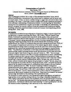
THE ARCHITECTURES
-
Interface layer which gives an opportunity to maintain all aspect of user friendly interface (GUI), Query layer is a layer to convert all public query to unpredictable spatio-temporal mode Data processing layer which will process the need to access, search, sort and manage any unpredictable spatiotemporal data Conversion layer is used internally to connect from unpredictable spatio-temporal mode to the supporting application that will be used Supporting application layer deals with all tools that are needed to maintain unpredictable spatio-temporal environment Physical layer is a layer where the physical data is stored Client User
Client User
INTERFACE LAYER
Visualisation Layer DIMaS System Entry Unpredictable Data Validation Predictable Data Resources
Query Preprocessing
Unpredictable data Management Schema Attribute Data Process- Structure Definition ing Process-ing Processing
WEB Protocol Management
Unpredictable and Predictable Physical Conversion Data
Other supporting Tools
QUERY LAYER
Predictable data Management
Unpredictable and Predictable Disaster Identification
Geographical Information System
SpatioTemporal DBMS 1
from 1 ….. To N
SpatioTemporal DBMS N
DATA PROCESSING LAYER
CONVERSION LAYER
SUPPORTING APPLICATION LAYER
SERVER LAYER
Fig 3.
SpatioTemporal Disaster Data
The other most challenging aspect in event-based services is that the demand of trajectories applications handling, visualizing and exploring moving objects trajectories is growing. Pattern in [5] provides a trajectory structure as a sequence of moves and stops in between, with begin and end events to represent a trajectory in a specific data model. There are many issues that should be considered such as complex maintenance when upgrading application.
III.
The proposed architecture on how unpredictable spatiotemporal database system should be implemented is depicted in Fig. 3. This figure illustrates an architecture for unpredictable spatio-temporal data maintaining which consists of 6 layers of functionality described as follow:
GIS Indonesian Map Data
B. Spatio-Temporal Model Challenges The challenge arises [4] in spatio-temporal database management system where spatio-temporal data handling was not a straightforward task due to the complexity of the data structures. It requires careful analysis in dimensions together with the representation and manipulation of the data involved. Research on spatio-temporal representations has focused on a number of specific areas, including: inexactness and scaling issues, integrated spatial data source, graphical user interfaces and query optimization, and indexing techniques for spatiotemporal databases.
activities space/time path, model spatio-temporal type, or mechanism of event detected.
Other Supporting Data
The spatio-temporal data model has been applied to the emergency-response phase, such as when the situation is crucial, no electricity support, no communication service exists. It is difficult to monitor the Rescue Team systematically and efficiently. All possible communication track shall be used, and the highest possible media is through mobile-phone. The location of the Rescue Team are dynamically changed, since they are moving around the disaster location. Fig. 2 depicted on how disaster event data can be structured according to the base map environment. The environment stores geographical element data structure for each disaster phases. It also stores any disaster properties related to a certain geographical Indonesian map, and to a valid and transaction time occurrences. The problem in capturing emergency disaster data becomes complex. The objects are moving and the reported data might become outdated. It is demanding that the emergency disaster data should be delivered appropriately on time, and rescue information should be sent back to the Rescue Team site. The challenge is that emergency disaster data needs to be managed, updated and modified frequently. Moving object data can be used to solve this challenge.
PHYSICAL LAYER
Unpredictable Spatio-Temporal Architecture
The predictable data will be normally processed according to the spatio-temporal data model which exists on the previous research [2]. Unpredictable data will be further managed by an undefined data generator. This data generator has a function to
approve new type of data input from the user and stores this new undefined data. Then the value of the unpredictable data can be processed through undefined support module. An additional module has been included here which has a function to identify any disaster object that cause moving object condition. This object condition could combined between defined and undefined objects. One specific module should be defined to give an environment for identifying, and separating between predictable and unpredictable disaster data. This module has a function as an intermediate module which will connect the event disaster data with the phase module (mitigation, emergency etc. module). This module is shown in Fig. 4 (dot rectangle). This intermediate module will be completed with an undefined sub-module.
event corresponds to damages, victim, and aids for the victims. There are also victims handling and aids distribution that must be managed during emergency responses activity. Disaster data has spatio-temporal attributes which describes the movement of disaster area over time. This spatial attributes were derived from the base map data and the temporal attributes were attached to disaster data. Predictable disaster data is data with defined attributes. These attributes represent characteristics of each disaster-related data. Modeling unpredictable data needs a special approach which will be described in Subsection A. The proposed model will also consider data representation for moving object. Moving object modeling will described in Subsection B. The overall proposed data model will be described in Subsection C. Damages
INTERMEDIATE MODULE Base Map
Disaster
Victims
Aids
Victims Handling
Aids Distribution
Emergency Responses
Fig 5.
Fig 4.
IV.
Unpredictable and Predictable Disaster Identification Module
THE PROPOSED SPATIO-TEMPORAL DATA MODEL
In this section, the proposed unpredictable spatio-temporal data model will be described. The proposed data model consists of all disaster data, especially data related to the emergency response activities shown in Table I. TABLE I. No 1 2 3 4 5 6 7
EMERGENCY RESPONSE ACTIVITIES Activities
Quick disaster responses study Planning the disaster emergency operations Developing center of emergency responses Monitoring the emergency response operations Finding Missing Victims Medical Handling Injured Victims Distribution of Aids
This data includes predictable and unpredictable data. Fig. 5 shows conceptual data model for disaster data. Each disaster
Conceptual Disaster Data Model
A. Modeling Unpredictable Disaster Data Unpredictable disaster data is related to the existence of any types of any disaster entities with undefined characteristics. For example, (1) there are types of disaster event data that cannot be predicted before. These disaster data can be characterized when the disaster actually happened, (2) there are many types of disaster mitigation that are not predefined, (3) there are types, quantities and distribution types of supply for the victims of the disaster that cannot be identified earlier. It must be considered that all of the attributes (as characteristics representative) of unpredictable data will be defined at runtime. A generic disaster data model should be defined to have the capability of handling various types of entities including unpredictable type. The model must support addition of a new attribute, as well as its type and value, at runtime. Unpredictable disaster data must be stored and manipulated in the same way of storing and manipulating disaster predictable data. Two approaches can be conducted: (1) using OODBMS, where the unpredictable disaster data can be stored as a new specific object of a more general object, or (2) defining the attributes of an unpredictable disaster data in a metadata table; this table will contain the name, the type, and the value of each attribute.
TABLE II.
UNPREDICTABLE DISASTER DATA
No
Description Data Entity Data representation for 1 OtherDisaster unpredictable disaster characteristics Data representation for 2 DamageObjects unpredictable damage objects Data representation for 3 OtherAids unpredictable aid needed in a particular disaster event Data representation for 4 OtherHandling unpredictable victim handling in a particular disaster event . The first approach is chosen after a careful analysis to several spatio-temporal DBMSs is conducted. Most spatio temporal DBMSs are OODBMS [8]. Choosing the second approach will need more effort, since the spatial and temporal attributes must be managed at the application level. Unpredictable disaster data, especially data related to the emergency response activities are shown in Table II. These data were derived from the conceptual data model shown in Fig. 5.
Each unpredictable disaster data entity is modeled as other objects (other disaster, other aids, other handling). All of these objects are derived from other object which holds predictable common attributes. DamageArea
B. Modeling Moving Object Spatio-temporal data model should be able to model moving object data. A single moving object can be illustrated as a certain UID undergoing changes in spatio-temporal attributes value, indicating the UID movement. Disaster related moving objects are (1) Disaster area and (2) Damage area, which may move as the disaster continue. C. The Proposed Data Model As the unpredictable disaster data and moving disaster object have been identified, the overall data model can be developed to cope with the class diagram to show relationship between class and object as shown in Fig. 6. The proposed model consists of predictable and unpredictable data as well as moving object data. Disaster data is represented as a collection of objects which consist of predictable disaster such as flood, tsunami, terrorism, etc., and unpredictable disaster data held in OtherDisaster object. Another unpredictable data are DamageObjects, OtherAids, and OtherHandling. Examples of spatio-temporal data which are also moving objects are DisasterArea and DamageArea. Other objects represent spatial data (AidDistributionCenter) or temporal data (TotalDisasterVictims, Aids, and Handling).
BaseMap
DamageObjects
Damages
DisasterArea
Aids
Volunteers
Disaster
OtherAids
TotalDisasterVictims
OtherDisaster
Victim
Handling
Logistic
MedicalHandling
Flood Tsunami Terorism Volcanic Eruption
AidDistributionCenter
Fig 6.
Disaster Data Model
OtherHandling
The proposed data model shown in Fig. 6 will be designed and implemented using existing DBMS to support DIMaS. require a very large effort to implement the Since it would complete system, an approach on prototyping development has been explored and decided [9]. The DIMaS prototype focuses on unpredictable data and moving object handling. V. EVALUATION Evaluation of the proposed data model can be conducted based on the prototype requirement. The proposed data model is considered to be valid if all of the defined requirements are satisfied. A single requirement is considered to be satisfied if related to the requirement can be executed over all data queries the implemented data model. Since the proposed data model refined, instead of conducting a comprehensive still needs to be evaluation, we can only conduct a more general evaluation. Example of DIMaS prototype requirement is to manage unpredictable disaster data, including add, update, delete, search, and view. Queries related to this requirement are: (1) define a new type (unpredictable) of disaster event and (2) capture the values of each attributes including new attributes. The first query will capture new characteristics of the disaster from the user input. The second query will capture data values for each attribute from the user input. The new attributes and its values will be used to create a new OtherDisaster object. The complete elaboration of all queries related to all prototype requirement has been done, which is not described here, to validate the proposed data model. VI.
queries will help us to verify the proposed data model. A more detail exploration on suitable spatio-temporal DBMS should also be conducted to prepare the implementation of the proposed data model. ACKNOWLEDGMENT We would like to acknowledge the BNPB Center, BPBD West Java, Aceh TDMRC, Mitigation Center ITB disasters for your cooperation in supporting the successful completion of this article as part of the Decentralize Research Program DIKTI 2014. REFERENCES [1] [2]
[3]
[4]
[5]
[6]
CONCLUSION AND FUTURE WORK
As a result, the architecture shown in Fig. 3 has been proposed. And the data model in Fig. 6 which is suitable to be implemented in the architecture using an existing spatiotemporal DBMS has been defined. The data model will be implemented in OODBMS that allows to add a new object at runtime. A new object definition will be used to handle unpredictable data. The proposed data model should be prepared for prototype implementation in the future. The data model must be refined by adding attributes for each object. The queries must be specified for each data handling functionality. Specifying
[7]
[8]
[9]
BNPB, Strengthening Disaster Information System in Asia, survey in Indonesia, 2010 Ismiraldi,Y., Aditya,R., Laksmiwati,H, , Widagdo,T.,.(DIMaS) Disaster Information Management System, PIT2 Forum Perguruan Tinggi Pengurangan Risiko Bencana/ PMB ITB/ Kedaton/ Bandung/ Nopember. 2009 Hira Laksmiwati, Karina Novita.S, Fazat N. Azizah, Chairul Ichsan, “Spatiotemporal Modeling for Disaster in Indonesia, Internationl Conference on Electrical Engineering and Informatics (ICEEI), Kuala Lumpur, Malaysia, 2013. Rainu Nandal; “Spatio-Temporal Database and Its Models: A Review”, IOSR Journal of Computer Engineering (IOSR-JCE) e-ISSn: 22780661, p-ISSN: 2278-8727, Volume 11, Issue 2 (May – June 2013) pp 91-100 Jimeng Sun,Dimitris Papadias, Yufei Tao, Bin Liu; “Querying about the Past, the Present and the Future in Spatio-Temporal Databases”, 20th International Conference on Spatio-Temporal, Data Engineering, 2004 Spaccapietra, S., C. Parent, M.D. Damiani, J.A. Macedo, F. Porto, and C. Vangenot (2008); “A Conceptual view on trajectories”, Data and Knowledge Engineering, pp 26 – 146. A.N.M. Bazlur Rashid, Md. Anwar Hossain; “Challenging Issues of Spatio-Temporal Data Mining” Computer Engineering and Intelligent Systems, ISSN 2222-1719 (Paper), ISSN 2222-2863 (Online) Vol 3, No 4, 2012. Li, Bonan and Guoray Cai. A general Object-Oriented Spatial Temporal Data Model. Symposium on Geospatial Theory, Processing and Application. Ottawa. 2002. Widyani, Yani., Hira Laksmiwati, Nisa’ul Hafidhoh, and Atika Yusuf, “Requirement Elicitation of Unpredictable Data Handling Prototype based on Spatio-Temporal Database for Disaster Information Management System (DIMaS)”, SNATIA 201