O'Neill, R.V., Johnson, A.R. and King, A.W. 1989. ... Paris. Risser, P.G., Forman, R.T.T. and Karr, J.R. 1984. Landscape ecology: directions and approaches.
Landscape Ecology vol. 3 nos. 3/4 pp 245-252 (1989) SPB Academic Publishing bv, The Hague
Predicting across scales: Theory development and testing Monica G. Turner, Virginia H. Dale and Robert H. Gardner Environmental Sciences Division, Oak Ridge National Laboratory, Oak Ridge, TN 37831, USA Keywords: landscape ecology, spatial scale, temporal scale, grain, extent, extrapolation, models
Abstract
Landscape ecologists deal with processes that occur at a variety of temporal and spatial scales. The ability to make predictions at more than one level of resolution requires identification of the processes of interest and parameters that affect this process at different scales, the development of rules to translate information across scales, and the ability to test these predictions at the relevant spatial and temporal scales. This paper synthesizes discussions from a workshop on ‘Predicting Across Scales: Theory Development and Testing’ that was held to discuss current research on scaling and to identify key research issues.
Introduction
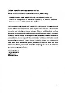
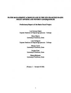
The range of spatial and temporal scales of ecological problems has expanded dramatically in recent years. Ecologists are now challenged by environmental problems that require landscape, continental, and even global levels of understanding. For example, predicting the effects of climatic change may require using ecological and atmospheric models that include processes that occur at the scale of a leaf and influence broad-scale atmospheric patterns (Fig. 1). Understanding hydrological systems and the effects of spatial heterogeneity on groundwater requires integrating across units that differ in size, shape, and arrangement (e.g., soil systems, surface wathersheds, groundwater networks) (Fig. 2). Ecologists are also being asked to predict responses that may not be manifested in the time frame of typical experimental studies. The identification of guiding principles that allow researchers to combine data and models at different spatial and temporal scales and to extra-
polate information between scales remains a challenge (Risser 1986; Rosswal et al. 1988). Remote sensing and geographic information systems can provide information at scales appropriate for analysis by spatially explicit statistical techniques (Bennett 1979; Delhomme 1978; Turner et al. in press), but the difficulty of replicating broad-scale experiments hinders our ability to address regional processes. The challenge is particularly acute for landscape ecology, which focuses on large heterogenous systems and attempts to integrate perspectives from different disciplines (Risser et al. 1984; Forman and Godron 1986; Turner 1989). The realization of the scale dependence of predictions is evident in recent studies in landscape ecology (Meentemeyer and Box 1987; O’Neill et al. 1988), physiological ecology (Jarvis and McNaughton 1986), soil processes (Sollins et al. 1983; Webster 1985), population interactions (Addicott et al. 1987; Wiens, in press), vegetation analysis (Getis and Franklin 1987), paleoecology (Delcourt et al. 1983), aquatic ecology (Steele 1978; Levasseur et al. 1984;
246
TREE GROWTH
DEFORESTATION
E!iFs FLUCTUATIONS: L°C&$$SuSE RIVER SEASONAL FLOW PRECIPITATION ,cju\ F%t?T BREEZE
1 Irm
Imm
lm
ikm SPACE SCALE
1oookm
Fig. 1. Space-time diagram of ecological and atmospheric processes illustrating the multiple spatial and temporal scales that must be considered. (Adapted from Dickinson 1988.)
ATMOSPHERE
m I
have not been developed, and limits to extrapolation have been difficult to identify. The objective of this paper is to synthesize the results and ideas that emerged from the workshop, ‘Predicting Across Scales: Theory Development and Testing’. We propose a set of working definitions for scale-related concepts, examine approaches for predicting across scales, and discuss future directions and research needs. Table 1. Definitions of scale-related terminology and concepts. Term
Definition
Scale
The spatial or temporal dimension of an object or process, characterized by both grain and extent.
Level of organization
The place within a biotic hierarchy (e.g., organism, deme, population).
Cartographic scale
The degree of spatial reduction indicating the length used to represent a larger unit of measure; ratio of distance on a map to distance on the earth surface represented by the map, usually expressed in terms such as 1: 10,000.
Resolution
Precision of measurement: grain size, if spatial.
Grain
The finest level of spatial resolution possible with a given data set; e.g., pixel size for raster data.
Extent
The size of the study area or the duration of time under consideration.
Extrapolate
To infer from known values; to estimate a value from conditions of the argument not used in the process of estimation; to transfer information (a) from one scale to another (either grain size or extent) or (b) from one system (or data set) to another system at the same scale.
Critical threshold
The point at which there is an abrupt change in a quality, property, phenomenon. ’
I
TERRESTRIAL VEGETATION
WATERSHEDS
GROUNDWATER LILY
Fig. 2. Study of the global hydrological cycle must integrate across units of the earth system that have different spatial and temporal dimensions. (Adapted from van der Heijde 1988.)
Carpenter and Kitchell 1987; Frost et al. 1988), remote sensing (Woodcock and Strahler 1987), and global change (Risser 1986; Rosswall et al. 1988). Scale problems have been acknowledged (e.g., Allen and Starr 1982; O’Neill et al. 1986; Meentemeyer and Box 1987; Rosswall et al. 1988), and the importance of spatial heterogeneity has been recognized (e.g., Risser et al. 1984; Forman and Godron 1986; Turner 1987, 1989). However, ‘scaling rules’
Absolute scale The actual distance, direction, shape, and geometry. Relative scale
A transformation of absolute scale to a scale that describes the relative distance, direction, or geometry based on some functional relationship (e.g., the relative distance between two locations based on the effort required by an organism to move between them).
247
Definitions and concepts of space, time, and scale The word scale is used in many contexts and often connotes different aspects of space and time. A common vocabulary and set of working definitions of scale-related concepts are necessary for discussion. We follow the definitions listed in Table 1 and distinguish between scale and level of biotic organization. Scale refers to the spatial or temporal dimension (e.g., size of area or length of time), whereas level of organization refers to the place within some biotic hierarchy (e.g., organism, deme, population). We categorize scale as is commonly done in ecology (e.g., fine scale refers to minute resolution or small study area, and broad scale refers to coarse resolution or large study area) rather than use the cartographic scale of geography (i.e., large scale refers to small resolution). We also differentiate between grain and extent, bQoth spatially and temporally (see also Turner et al. 1989), Grain refers to the finest level of spatial or temporal resolution available within a given data set. Extent refers to size of the study area or the duration of the study. Discussing the extrapolation of information from one scale to another requires the use of several other terms. The term extrapolation refers to the process of estimating unknown values from a known set of conditions. The process can be used to transfer information from a landscape of one set of dimensions to a larger set of dimensions or from a reference landscape to another area of equal dimensions. However, the transformation is difficult if it exceeds some limit, or ‘critical threshold,’ at which there is an abrupt change in some quality, property, or phenomenon of the system. Scale transformations may also be performed by using measures of ‘relative scale,’ in which units of absolute scale (e.g., distance or geometry) are changed to untis based on some functional relationship (e.g., units representing the energy to move from one location to another) (Meentemeyer 1989).
Approaches for predicting across scales The procedure for making predictions across more
than one scale has at least four parts. First, the spatial and temporal scale of the process must be identified. Second, the way in which controlling factors vary with scale must be understood. Third, the appropriate methods to translate predictions from one scale to another must be developed. Finally, the methods and predictions must be empirically tested across multiple scales. The following sections examine each of these four approaches.
Identification of scales
Scales are determined by observer-dependent criteria (Allen and Starr 1982), and the scales must be appropriate for the phenomenon of interest. Existing analytical methods (e.g., power spectra, fractals, multiscale ordination, Fourier transformation, fracture theory) may assist in the identification of the scales at which different organisms or processes operate. For example, a plot of the power spectrum versus scale can be used to identify regularities and thresholds at broad scales (Steele 1989). Similarly, a plot of fractal dimension versus scale can identify scale-dependent changes in pattern which may reflect the underlying processes creating those patterns (e.g., Krummel et al. 1987; Milne 1988). Ordination methods have been used in vegetation analysis to describe pattern and relate it to underlying gradients such as water availability (e.g., Noy-Meir 1971). A wide range of statistical techniques for identifying scale in landscape analyses has been reviewed and evaluated by Turner et al. (in press). Empirical methods can also be used to determine the spatial and temporal scales of processes. FOT example, the return interval for catastrophic fires in Yellowstone National Park was empirically determined to be 200 to 300 years by using tree ring analyses and landscape pattern data (Romme 1982; Romme and Knight 1982). The paleoecological record, in which biotic responses to environmental events are preserved, is also an important data source for empirical studies (e.g., Barnosky 1984; Davis and Botkin 1985). The scale of historical climate change and vegetation responses (e.g., ecotone dynamics) have been described using paleoeco-
248
logical records (e.g., Delcourt and Delcourt 1988). Because biological processes may be controlled by the scale of dominant physical processes (Meentemeyer and Box 1987), it is possible to identify the appropriate scales for many systems based on abiotic processes. For example, the spatial and temporal scales of biological activity in aquatic systems are tightly coupled to the scales of physical phenomena such as thermoclines, currents, or gyres (Steele 1989). The biota respond to changes in the scale of physical processes by adapting, tracking, smoothing, or incorporating the scale changes. Blooms of blue-green algae are controlled by factors that occur at many scales, but physical changes at broader scales constrain the options available at finer scales (Carpenter 1989). Broad-scale constraints can aid in predicting biotic responses at other scales.
Understanding the importance of parameters at different scales
The variables influencing a process may or may not change with scale, but a shift in the relative importance of variables often occurs (Meentemeyer and Box 1987). For example, the prediction of sitespecific decomposition rates requires detailed knowledge of environmental variability, microclimate, and litter characteristics such as lignin concentration. At regional to global scales, however, temperature and precipitation are sufficient to predict decomposition rates (Meentemeyer 1978, 1984). Similarly, evapotranspiration is controlled by vapor pressure surface deficit and stomatal processes at the scale of a single leaf or tree, whereas radiation is the driving variable at regional scales (Jarvis and McNaughton 1986). The distributions of species may also be explained differently at different scales. For example, oak seedling mortality at local scales decreases with increasing precipitation, whereas mortality at regional scales is lowest in the drier latitudes (Neilson and Wulstein 1983). Therefore, predicting across scales requires that the changes in the relative importance of parameters with scale be understood. The explanatory power of a set of variables can
be evaluated experimentally at different scales by using analytical techniques (e.g., regression) and varying the grain or extent of the analysis. However, considerably more research is necessary to identify changes in constraints. There was a consensus among workshop participants that multiscale experiments, in which spatial or temporal scale is an independent variable, are crucial. Theoretical methods may assist in predicting changes in the importance of parameters with changing scale. Methods adpated from percolation theory have been used to simulate the relationship between landscape pattern and the movement of organisms at spatial scales that varied in both grain and extent (Gardner et al. 1989). These theoretical studies predicted the existence of critical thresholds in spatial patterns and identified changes in the important variables above and below the critical threshold. Because multiscale empirical studies are logistically challenging, predictions from theoretical studies should be particularly valuable in designing experiments to test scale-related hypotheses.
Translating across scales
Methods to translate across scales include both ‘top-down’ and ‘bottom-up’ approaches. The topdown method uses the concept of constraint to predict phenomena at finer scales. The objective is to identify the constraints that are important at each scale. For example, solar radiation is used to predict global patterns of evapotranspiration, whereas stomata1 conductance is used to predict evapotranspiration in individual leaves or plants (Jarvis and McNaughton 1986). The top-down approach can use many of the ideas of hierarchy theory to extrapolate between scales (O’Neill et al. 1989). The bottom-up approach begins with individual or entity-based measurements and adds appropriate constraints to explain the resultant phenomena at broader scales. The objective here is to use information that is available at fine scales to predict phenomena at broader scales for which empirical data are lacking. The merits of each approach continue to be subjects of debate (e.g.,
249 Huston et al. 1988). Both approaches will be necessary because of the suite of broad-scale environmental problems facing ecologists and the paucity of data at broad scales. Simulation models are useful to develop methods to extrapolate across scales because they can test the implications of various scaling rules. For example, Gardner et al. (1989) used a simple model to predict animal movement across a heterogeneous landscape when the spatial scale was varied in different ways. Simulation models can also be subjected to uncertainty analyses that detect errors that occur as a result of extrapolating from a few plots to a region (Dale et al. 1988). Models can also be used to examine phenomena on either side of a critical threshold in order to develop procedures to translate predictions reliably across scales (Gardner et al. 1987). Physical models may also be important in developing methods to extrapolate across scales. Models of mechanical objects for which scaling relationships are known (e.g., ships, aircraft) are frequently used to elucidate dynamical properties at larger scales. However, the components for the small- and large-scale mechanical systems are generally the same, whereas changes in the scale of biological model systems (e.g., microcosms, mesocosms) result in a number of different conditions. First, the quality (species) and quantities (e.g., individuals/ area or volume) vary with scale. Second, the influence of boundary conditions, such as fences or tank walls, on biological components is scale dependent. Finally, the simulation of natural physical and chemical conditions as a function of scale is essential to realistic behavior of the model system. These conditions can be met in small physical models, as demonstrated by their ability to mimic a dynamical property of the larger natural system being studied (Dwyer and Perez 1983). Because the physical enclosure or containment of large biotic systems is difficult, mesocosms may be the most useful physical model of ecological systems. If system boundaries are correctly established, then experimental models can predict dynamic properties and selected state variables in large-scale systems. Physical models, used in conjunction with mathematical models and field studies, can be expected to con-
tribute to a thorough understanding of the relationship between biotic complexity and scale. Defining limits to extrapolation is necessary to translate information across scales, but more research is needed to address this. The workshop participants hypothesized that error associated with an extrapolation may increase as the change in the number of levels, grain sizes, or extent becomes greater. For example, the error associated with extrapolating CO, uptake from a forest plot to a whole stand might be less than the error in extrapolating the same measurement from a forest plot to an entire region. It was further hypothesized that, if variance was measured as a function of scale, increased variance associated with changing scale may indicate the approach of a critical threshold. Extrapolation might then be possible within, but not beyond, the bounds of the threshold (see also Rosen 1989). Another hypothesis to explore is that extrapolations between fine and broad scales may not be symmetrical. For example, it may be easier to scale from smaller to larger grain sizes or extent than to scale down to finer levels of resolution. In the absence of detailed knowledge, scaling down to finer levels may not be possible unless the concept of self-similarity can be applied. Spatial heterogeneity appears to constrain our ability to translate information from one scale to another. In a simple example, Turner et al. (1989) experimentally varied the grain and extent of landscape data to observe the effects of changing spatial scale on the analysis of landscape pattern. The results indicated that the organization, or pattern, of the landscape influenced the response of measurements to changes in spatial scale. Discussions at the workshop suggested that scale problems may not occur in spatially homogeneous systems because process measurements could be summed directly. However, in heterogeneous landscapes or aquatic systems, process measurements obtained at fine scales often cannot be summed directly to produce regional estimates. Weighted averages do not always produce reasonable measures (King et al. 1988) because heterogeneity may influence processes in nonlinear ways. This suggests that the possibility that increasing the level of spatial heterogeneity also increases the difficulty of
250 extrapolating information across scales.
Sampling and experimentation across scales Unless it is part of the experimental design, the spatial or temporal scale of an experiment is fixed once a sampling scheme is selected. The typical approach to ecological studies is to specify the question of interest and design a sampling scheme to estimate the appropriate parameter. However, it is necessary to have an understanding of the spatial and temporal characteristics of the process. For example, weekly sampling in lakes is, not sufficient to study processes which operate on smaller or longer time scales (Carpenter 1989). Samples collected at 2- to 3-day intervals showed a negative relationship between phytoplankton and zooplankton, whereas samples collected at lo- to 1Cday intervals showed a positive relationship. The traditional week-long sample interval cannot detect any relationship between phytoplankton and zooplankton! The effect of sampling interval on benthic processes was also well documented by Livingston (1987). Therefore, it may sometimes be necessary to sample processes at several scales in order to identify these dependencies. A suggestion from workshop participants was that an ‘adaptive approach’ (sensu Holling 1978) to sampling might be used when scale is suspected to be important. This approach would involve choosing a reasonable sampling scheme at a specific spatial-temporal scale but augmenting the study with samples at other scales. The robustness of the study could then be assessed with respect to scale. If the study results were not robust, the adaptive approach recommends that additional samples at other spatial or temporal scales should be obtained. Simultaneous measurements at multiple scales are desirable, but this type of sampling is only beginning to be applied (but see Hall et al. 1988). New technologies may permit measurements to be made at multiple scales or at mesoscales (Gosz and Sharpe 1989). Empirical studies using multiplescale or mesoscale measures should also make significant contributions to our understanding of the effects of spatial heterogeneity on extrapolation.
Future directions and research needs As ecologists continue to grapple with broad-scale questions in landscape and global ecology, scalerelated considerations must be addressed. The discussions at this workshop have suggested the following ideas for future research: - Define the objectives of ecological studies with an awareness of scale effects. - Study the level of organization and spatialtemporal scales that are appropriate to the question. - Identify critical thresholds or break points in patterns and processes. - Consider multiscaled studies, both spatially and temporally, in which scale is an independent variable. - Consider the importance of measuring and modeling variance, rather than means, particularly near critical thresholds. - Develop ‘rules’ for incorporating the effects of spatial heterogeneity on processes at various scales. - Consider the relative rates of system components, and consider relative scale. - Develop and test theory for monitoring responses at one scale but predicting effects at another scale. The study of scaling issues is a major contribution of landscape ecology to ecological sciences and the management of biological resources. By explicitly defining and discussing scaling concepts, landscape ecologists are providing a lead to other researchers in relating ecological data that are collected at a fine scale to environmental problems which are pervasive at broad scales. The continued development of theory and methods for predicting information across broad spatial and temporal scales requires that scaling issues be recognized within the scientific community, current information be synthesized into a set of principles, and practical techniques for extrapolating across scales be developed and applied. The articles collected in this volume, although not all strictly focused on landscape issues, present a diversity of theoretical and empirical approaches to the problems of predictions across scales.
251 Acknowledgments This paper synthesizes the discussions of participants at a workshop held November 8- 11,1988, in Oak Ridge, Tennessee, and we thank each participant for contributing ideas. Critical comments from R.V. O’Neill and K.A. Rose improved the manuscript. Support was provided by the Ecological Research Division, Office of Health and Environmental Research, U.S. Department of Energy, under contract DE-AC05-840R21400 with Martin Marietta Energy Systems, Inc., and by a grant from the Ecosystem Studies Program of the National Science Foundation. Support for M.G. Turner was provided by Department of Energy’s Alexander P. Hollaender Distinguished Postdoctoral Fellowship, administered by Oak Ridge Associated Universities. Publication No. 3378 of the Environmental Sciences Division, ORNL. References Addicott, J.F., Aho, J.M., Antolin, M.F., Padilla, D.K., Richardson, J.S. and Soluk, D.A. 1987. Ecological neighborhoods: scaling environmental patterns. Oikos 49: 340-346. Allen, T.F.H. and Starr, T.B. 1982. Hierarchy: perspectives for ecological complexity. The University of Chicago Press, Chicago. Barnosky, C.W. 1984. Late Miocene vegetational and climatic variations inferred from a pollen record in northwest Wyoming. Science 223: 49-51. Bennett, R.J. 1979. Spatial time series. Pion, London. Carpenter, S.R. 1989. Temporal variance in lake communities: blue-green algae and the trophic cascade. Landscape Ecol. 3: 175-184. Carpenter, S.R. and Kitchell, J.F. 1987. The temporal scale of variance in limnetic primary production. Am. Nat. 129: 417433. Dale, V.H., Jager, H.I., Gardner, R.H. and Rosen, A.E. 1988. Using sensitivity and uncertainty analyses to improve predictions of broad-scale forest development. Ecol. Modell. 42: 165-178. Davis, M.B. and Botkin, D.B. 1985. Sensitivity of cool-temperate forests and their fossil pollen record to rapid temperature change. Quat. Res. 23: 327-340. Delcourt, H.R. and Delcourt, P.A. 1988. Quaternary landscape ecology: relevant scales in space and time. Landscape Ecol. 2: 23-44. Delcourt, H.R., Delcourt, P.A. and Webb, T. 1983. Dynamic plant ecology: the spectrum of vegetation change in space and time. Quat. Sci. Rev. 1: 153-175.
Delhomme, J.P. 1978. Kriging in the hydrosciences. Adv. Water Resour. 1: 251-266. Dickinson, R.E. 1988. Atmospheric systems and global change. In Scales and Global Change. pp. 57-80. Edited by T. Rosswall, R.G. Woodmansee and P.G. Risser. John Wiley and Sons, New York. Dwyer, R.L. and Perez, K.T. 1983. An experimental examination of ecosystem linearization. Am. Nat. 121: 305-323. Forman, R.T.T. and Godron, M. 1986. Landscape ecology. John Wiley and Sons, New York. Frost, T.M., DeAngelis, D.L., Allen, T.F.H., Bartell, S.M. and Hall, D.J. 1988. Scale in the design and interpretation of aquatic community research. In Complex Interactions in Lake Communities. pp. 229-258. Edited by S.R. Carpenter. Springer-Verlag, New York. Gardner, R.H., Milne, B.T., Turner, M.G. and O’Neill, R.V. 1987. Neutral models for the analysis of broad-scale landscape pattern. Landscape Ecol. 1: 19-28. Gardner, R.H., O’Neill, R.V., Turner, M.G. and Dale, V.H. 1989. Quantifying scale-dependent effects of animal movement with simple percolation. models. Landscape Ecol. 3: 217-227. Getis, A. and Franklin, J. 1987. Second-order neighborhood analysis of mapped point patterns. Ecology 68: 473-477. Gosz, J.R. and Sharpe, P.J.H. 1989. Broad-scale concepts for interactions of climate, topography, and biota at biome transitions. Landscape Ecol. 3: 229-243. Hall, F.G., Strebel, D.E. andsellers, P.J. 1988. Linking knowledge among spatial and temporal scales: vegetation, atmosphere, climate and remote sensing. Landscape Ecol. 2: 3-22. Holling, C.S. (ed.) 1978. Adaptive environmental assessment and management. John Wiley and Sons, New York. Huston, M., DeAngelis, D. and Post, W. 1988. New computer models unify ecological theory. Bioscience 38: 682-691. Jarvis, P.G. and McNaughton, K.G. 1986. Stomata1 control of transpiration: Scaling up from leaf to region. Adv. Ecol. Res. 15: l-49. King, A.W., DeAngelis, D.L. and Post, W.M. 1988. The seasonal exchange of carbon dioxide between the atmosphere and the terrestrial biosphere: extrapolation from site-specific models to regional models. ORNL /TM-10570. Oak Ridge National Laboratory, Oak Ridge, Tennessee. Krummel, J.R., Gardner, R.H., Sugihara, G. and O’Neill, R.V. 1987. Landscape patterns in a disturbed environment. Oikos 48: 321-324. Levasseur, M., Therriault, J.C. and Legendre, L. 1984. Hierarchical control of phytoplankton succession by physical factors. Mar. Ecol. Prog. Ser. 19: 211-222. Livingston, R.J. 1987. Field sampling in estuaries: the relationship of scale to variability. Estuaries 10: 194-207. Meentemeyer, V. 1978. Macroclimate and lignin control of litter decomposition rates. Ecology 59: 465-472. Meentemeyer, V. 1984. The geography of organic decomposition rates. Ann. Assoc. Am. Geogr. 74: 551-560. Meentemeyer, V. 1989. Geographical perspectives of space, time and scale. Landscape Ecol. 3: 163-173.
252 Meentemeyer, V. and Box, E.O. 1987. Scale effects in landscape studies. In Landscape Heterogeneity and Disturbance. pp. 15-36. Edited by M.G. Turner. Springer-Verlag, New York. Milne, B.T. 1988. Measuring the fractal dimension of landscapes. Appl. Math. Comput. 27: 67-79. Neilson, R.P. and Wulstein, L.H. 1983. Biogeography of two southwest American oaks in relation to atmospheric dynamics. J. Biogeogr. 10: 275-297. Noy-Meir, I. 1971. Multivariate analysis of desert vegetation. II. Qualitative-quantitative partition of heterogeneity, Vegetatio 29: 179-190. O’Neill, R.V., DeAngelis, D.L., Waide, J.B. and Allen, T.F.H. 1986. A hierarchical concept of ecosystems. Princeton University Press, Princeton, New Jersey. O’Neill, R.V., Milne, B.T., Turner, M.G. and Gardner, R.H. 1988. Resource utilization scales and landscape pattern. Landscape Ecol. 2: 63-69. O’Neill, R.V., Johnson, A.R. and King, A.W. 1989. A hierarchical framework for the analysis of scale. Landscape Ecol. 3: 193-205. Risser, P.G. 1986. Spatial and temporal variability of biospheric and geospheric processes: research needed to determine interactions with global environmental change. The ICSU Press, Paris. Risser, P.G., Forman, R.T.T. and Karr, J.R. 1984. Landscape ecology: directions and approaches. Special Publications No. 2. Illinois Natural History Survey, Champaign. Romme, W.H. 1982. Fire and landscape diversity in subalpine forests of Yellowstone National Park. Ecol. Monogr. 52: 199-221. Romme, W.H. and Knight, D.H. 1982. Landscape diversity: the concept applied to Yellowstone Park. Bioscience 32: 664670. Rosen, R. 1989. Similitude, similarity, and scaling. Landscape
Ecol. 3: 207-216. Rosswall, T., Woodmansee, R.G. and Risser, PG. (eds.) 1988. Scales and global change. John Wiley and Sons, New York. Sollins, P., Spycher, G. and Topik, C. 1983. Processes of soil organic-matter accretion at a mudflow chronosequence, Mt. Shast, California. Ecology 64: 1273-1282. Steele, J.H. (ed.) 1978. Spatial pattern in plankton communities. Plenum Press, New York. Steele, J.H. 1989. The ocean ‘landscape.’ Landscape Ecol. 3: 185-192. Turner, M.G. (ed.) 1987. Landscape Heterogeneity and Disturbance. Springer-Verlag, New York. Turner, M.G. 1989. Landscape ecology: the effect of pattern on process. Annu. Rev. Ecol. Syst. 20: 171-197. Turner, M.G., O’Neill, R.V., Gardner, R.H. and Milne, B.T. 1989. Effects of changing spatial scale on the analysis of landscape pattern. Landscape Ecol. 3: 153-162. Turner, S.J., O’Neill, R.V., Conley, W., Conley, M.R. and Humphries, H.C. Pattern and scale: statistics for landscape ecology. In Quantitative Methods in Landscape Ecology. Edited by M.G. Turner and R.H. Gardner. Springer-Verlag, New York (in press). van der Heijde, P.K.M. 1988. Spatial and temporal scales in groundwater modelling. In Scales and Global Change. pp. 195-224. Edited by T. Rosswall, R.G. Woodmansee and P.G. Risser. John Wiley and Sons, New York. Webster, R. 1985. Quantitative spatial analysis of soil in the field. In Advances in Soil Science, Vol. 3. pp. 2-70. Edited by B.A. Stewart. Springer-Verlag, New York. Wiens, J.A. Spatial scaling in ecology. Functional Ecology (in press). Woodcock, C.E. and Strahler, A.H. 1987. The factor of scale in remote sensing. Remote Sensing Environ. 21: 31 l-332.