P1.15
A NEW CONVECTIVE SOUNDING ANALYSIS PROGRAM FOR AWIPS Matthew J. Bunkers* NOAA/NWS Weather Forecast Office, Rapid City, South Dakota
1.
INTRODUCTION∗
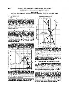
Sounding analysis of kinematic and thermodynamic data—both observed and model-derived—is a critical component of convective storm forecasting. The Advanced Weather Interactive Processing System (AWIPS) has the ability to display both skewT−logP diagrams and hodographs, but not all of the desired parameters for convective storm forecasting are readily available (e.g., energy-helicity index, vorticity generation potential). Moreover, it is a slow process to get recent research (e.g., new supercell motion algorithm, 0−1-km storm-relative helicity) incorporated into future AWIPS builds. Finally, the display of the vertical wind shear distribution (via the hodograph) is undesirable for effectively anticipating convective storm mode because it does not provide an easily interpreted visual representation of shear in differing layers. As a result of these shortcomings, several scripts and a C program were written which calculate all of the desired convective parameters and output the data as a text product for viewing in AWIPS. In addition to being able to view all of these parameters, updates for additional parameters can easily be made without having to go through the long process of requesting a change to be included in future AWIPS builds. This paper provides a description of this software. 2.
ALGORITHM & SOFTWARE DESCRIPTION
2.1
Extracting Data from netCDF Files
The first part of the process to generate sounding parameters is the extraction of data into a suitable format. For this purpose, a utility called ncRead was used that extracts data from netCDF files based on specification of (i) variable name, (ii) starting grid point location, and (iii) ending grid point location; other output options are also available. This program was developed by Carl Dierking from the Juneau, AK, National Weather Service, and is available via anonymous FTP from inetsrv.arh.noaa.gov (cd /pub/apps/decoders). After the appropriate observed or model data are extracted from the netCDF files, they are manipulated via UNIX commands into a file suitable to be used as input to the C program. 2.2
Quality Control of Observed Data
The model sounding data are assumed to be complete with no erroneous or missing data, therefore no attempts are made within the C program to correct model data. There are, however, many potential problems with observed sounding data (e.g., Bosart 1990; Elliott and Gaffen 1991; Schwartz and Doswell 1991). Although most of the erroneous data are caught by manual and automated quality control schemes, there are a few occasions when bad data are disseminated. Most of the time this is in the form of erroneous surface data, but others can result from digital transmission errors. As a result, there is a simple quality control scheme employed in the
* Corresponding author address: Matthew J. Bunkers, Natl. Wea. Serv., 300 E. Signal Dr., Rapid City, SD 57701-3800; e-mail:
[email protected].
C program that checks for data range tolerance, lapse rates, and missing or insufficient data. 2.3
Calculation of Convective Parameters
The list of parameters that are calculated include (see Table 1): (i) convective available potential energy (CAPE), (ii) convective inhibition (CIN), (iii) lifted index (LI), (iv) height of the LCL (hgtLCL), (vi) height of the level of free convection (hgtLFC), (vii) height of the equilibrium level (hgtEL), (viii) bulk Richardson number (BRN), (ix) vorticity generation potential (VGP), (x) energy helicity index (EHI), (xi) warm cloud depth (WCD), (xii) maximum updraft velocity based on parcel theory (wmax), (xiii) storm-relative helicity for the right-moving (SRH_RM) and left-moving supercells (SRH_LM), (xiv) total vertical wind shear in the 0−3-km (Us3), 0−6-km (Us6), and 0−8-km (Us8) layers, (xv) bulk vertical wind shear in the 0−6km layer (Bulk6), (xvi) BRN shear (BRNSHR), (xvii) 0−6-km mean wind (MeanWind), (xviii) Froude number (Froude), (xix) total totals index (TTotl), (xx) K index (KIndx), (xxi) 700−500hPa lapse rate (Lapse), (xxii) wet bulb zero height (WBZ), (xxiii) maximum theta-E difference below 300 hPa, (xxiv) average mixing ratio in the lowest 1 km (AvgMXR), and (xxv) surface to 300 hPa relative humidity [RH(Sfc-3)], precipitable water [PW(Sfc-3)] percent of normal precipitable water [PW(%Norm)], and the standard deviation of the precipitable water [PW(dev)]. The three parcel choices are the (i) most-unstable in the lowest 300 hPa of the sounding (MU), (ii) mixed layer in the lowest 1km of the sounding (ML), and surface-based (SB). The thermodynamic equations from Bolton (1980) were used wherever possible, and the CAPE and CIN were calculated according to Doswell and Rasmussen (1994). Definitions of the convective parameters can be found in Miller (1972), Bluestein (1993), or Rasmussen and Blanchard (1998). The supercell motion algorithm of Bunkers et al. (2000) was used for SRH_RM and SRH_LM. Normal values of precipitable water were obtained from the 1948-2000 radiosonde climatology. 2.4
Inclusion of Climatological Parameters
One of the benefits of this program is the ability to calculate departures from normal as well as the standard deviation of an observed variable, such as is done for precipitable water. It would be relatively easy to incorporate these calculations into the program for other variables—height, temperature, and humidity at standard levels. This has been done for horizontal fields of these variables, proving to be useful in quantifying extreme events (Hart and Grumm 2001). 2.5
Running the Program
The program can be run either automatic or manually. Automation is the most practical choice in the case of observed soundings since these are released at standard times. In the case of nonstandard sounding release times, the program can be run manually from the AWIPS main menu. For model data, the manual method is most pragmatic since there are many grid points to chose from at one-, three-, six-, or twelve-hourly increments. In this case, the user can make predefined selections of grid points across their area of concern, and then
incorporate this information into the command line used in the AWIPS main menu. 3.
OUTPUT
At present there is no graphical user interface to view the output; rather, the output is made available via the textdb command, which is used to write the output to the text database (e.g., Table 1). There are many other output possibilities, which may be useful for further interrogation of data in a spreadsheet. For example, wind data from the surface to 8 km are currently used to generate hodographs on an Excel spreadsheet, which makes it much easier to view vertical wind shear in varying layers. 4.
SUMMARY
A local application has been developed that will calculate parameters for convective storm forecasting that are not readily available on AWIPS. For example, instability parameters are simultaneously output for the MU, ML, and SB parcels using the virtual temperature correction, which allows for easy intercomparison of the lifting methods. Also, climatological precipitable water values are incorporated into the program to assess the difference from normal and the standard deviation. Future plans call for a graphical user interface to generate skewT−logP diagrams and hodographs. The software is available upon request from the author. 5.
ACKNOWLEDGMENTS
The author would like to thank Dave Carpenter and Brian Klimowski for supporting this work. 6.
REFERENCES
Bluestein, H. B., 1993: Synoptic-Dynamic Meteorology in Midlatitudes, Volume II: Observations and Theory of Weather Systems. Oxford University Press, 594 pp. Bolton, D., 1980: The computation of equivalent potential temperature. Mon. Wea. Rev., 108, 1046-1053. Bosart, L. F., 1990: Degradation of the North American radiosonde network. Wea. Forecasting, 5, 689-690. Bunkers, M. J., B. A. Klimowski, J. W. Zeitler, R. L. Thompson, and M. L. Weisman, 2000: Predicting supercell motion using a new hodograph technique. Wea. Forecasting, 15, 61-79. Doswell, C. A., III, III, and E. N. Rasmussen, 1994: The effect of neglecting the virtual temperature correction on CAPE calculations. Wea. Forecasting, 9, 625-629. Elliott, W. P., and D. J. Gaffen, 1991: On the utility of radiosonde humidity archives for climate studies. Bull. Amer. Meteor. Soc., 72, 1507-1520. Hart, R. E., and R. H. Grumm, 2001: Using normalized climatological anomalies to rank synoptic-scale events objectively. Mon. Wea. Rev., 129, 2426-2442. Miller, R. C., 1972: Notes on analysis and severe-storm forecasting procedures of the Air Force Global Weather Central. Air Weather Service Tech. Rep. 200 (Rev.), Air Weather Service Headquarters, Scott Air Force Base, IL, 190 pp. Rasmussen, E. N., and D. O. Blanchard, 1998: A baseline climatology of sounding-derived supercell and tornado forecast parameters. Wea. Forecasting, 13, 1148-1164. Schwartz, B. E., and C. A. Doswell III, 1991: North American radiosonde observations: Problems, concerns, and a call to action. Bull. Amer. Meteor. Soc., 72, 1885-1896.
Table 1. Convective output from the new convective sounding analysis program described herein, for 0000 UTC 9 Sep 2001 at Rapid City, SD, as it would appear in the AWIPS text database. KUNR Sounding Statistics for 20010909_0000 ---------------------------------------------------1 MUCAPE = 381 J kg -1 MUCIN = -3.8 J kg MULI = -1.9 C MUhgtLCL = 563 m AGL MUhgtLFC = 936 m AGL MuhgtEL = 6710 m AGL MUBRN = 76 MUVGP = 0.09 MUEHI = 0.0 MUWCD = 772 m -1 WmaxMU = 27.6 m s ---------------------------------------------------1 MLCAPE = 54 J kg -1 MLCIN = -14.5 J kg MLLI = -0.2 C MLhgtLCL = 1118 m AGL MLhgtLFC = 2913 m AGL MlhgtEL = 5776 m AGL MLBRN = 11 MLVGP = 0.03 MLEHI = 0.0 MLWCD = 50 m -1 WmaxML = 10.3 m s ---------------------------------------------------1 SBCAPE = 381 J kg -1 SBCIN = -3.8 J kg SBLI = -1.9 C SBhgtLCL = 563 m AGL SBhgtLFC = 936 m AGL SbhgtEL = 6710 m AGL SBBRN = 76 SBVGP = 0.09 SBEHI = 0.0 SBWCD = 772 m -1 WmaxSB = 27.6 m s --------------------------------------------------2 -2 = -1 m s SRH_RM3km 2 -2 = -10 m s SRH_RM1km 2 -2 = -54 m s SRH_LM3km 2 -2 = -31 m s SRH_LM1km -1 Us3 = 14 m s -1 Us6 = 24 m s -1 Us8 = 39 m s -1 Bulk6 = 5ms 2 -2 BRNSHR = 5m s MeanWind = 291°/16 kts Froude = 0.60 TTotl = 55 C KIndx = 28 C -1 Lapse = 7.2 C km WBZ = 980 m AGL TE Diff = 5.8 C -1 AvgMXR = 5.0 g kg RH(Sfc-3) = 69% PW(Sfc-3) = 0.48 inches PW(%Norm) = 81% PW(dev) = -0.5 StdDev