May 5, 2013 ... adjacent to the operating Luce Mine and to the west of and adjacent to the
Smokey. Mountain ... Uashat mak Mani-Utenam (Quebec Innu community) ......
1971-2000 at the Wabush Airport climate station (Climate ID: 8504175).
IRON ORE COMPANY OF CANADA WABUSH 3 OPEN PIT MINE PROJECT LABRADOR WEST Environmental Assessment Registration Pursuant to the Newfoundland & Labrador Environmental Protection Act
Description of a Designated Project Pursuant to the Canadian Environmental Assessment Act, 2012 Submitted by: Iron Ore Company of Canada 2 Avalon Drive Labrador City, Newfoundland & Labrador A2V 2Y6 Prepared with the assistance of: AMEC Environment & Infrastructure, A division of AMEC Americas Limited 133 Crosbie Road, PO Box 13216 St. John's, Newfoundland & Labrador A1B 4A5
May, 2013 June 6, 2013 Rev.1for submission as Description of a Designated Project Pursuant to the Canadian Environmental Assessment Act, 2012
Table of Contents List of Acronyms ........................................................................................................................ vi 1.0 .............................................................................................................................................. Introduction 1 1.1 The Proponent................................................................................................................ 2 1.2 Nature of and Rationale for the Project ........................................................................... 3 1.3 Environmental Assessment Processes and Requirements ............................................. 3 1.4 Purpose of the EA Registration and Project Description Document ................................ 4 2.0 ..................................................................................................................................Project Description 5 2.1 Geographic Location ...................................................................................................... 5 2.2 Alternatives to the Project ..............................................................................................11 2.3 Land Ownership ............................................................................................................11 2.4 Wabush 3 Project Components, Layout and Processes ................................................13 2.4.1 Wabush 3 Resource Information and Role in IOC Mine Plan ........................... 13 2.4.2 Wabush 3 Open Pit Mine Development and Operation .................................... 16 2.4.3 Overburden Handling ....................................................................................... 23 2.4.4 Waste Rock Disposal ....................................................................................... 23 2.4.5 Haulage Roads ................................................................................................ 24 2.4.6 Mine Water and Groundwater Extraction - Collection, Treatment and Disposal 25 2.4.7 Associated Infrastructure .................................................................................. 27 2.5 Construction/Development ............................................................................................31 2.6 Operations and Maintenance .........................................................................................33 2.6.1 Open Pit ........................................................................................................... 33 2.6.2 Waste Rock Disposal Areas ............................................................................. 35 2.6.3 Maintenance and Response Procedures .......................................................... 35 2.7 Closure and Decommissioning ......................................................................................36 2.8 Possible Accidents and Malfunctions .............................................................................36 2.9 Effects of the Environment on the Project ......................................................................36 2.10 Project Schedule ...........................................................................................................37 2.11 Labour Force and Occupations .....................................................................................37 2.12 Wabush 3 Project Documents .......................................................................................40 2.13 Wabush 3 Project Cost and Funding .............................................................................40 2.14 Environmental Management and Protection ..................................................................40 2.14.1 Environmental Protection Plan(s) ..................................................................... 42 2.14.2 Emergency Response and Reporting Plan(s) ................................................... 44 2.15 Other Required Environmental Approvals ......................................................................45 3.0 ..............................................................................................................................Existing Environment 46 3.1 Natural Environment ......................................................................................................46 3.1.1 Climate ............................................................................................................. 46 3.1.2 Air Quality and Noise........................................................................................ 47 3.1.3 Geology and Topography ................................................................................. 54 3.1.4 Vegetation and Soils ........................................................................................ 55 3.1.5 Wetlands .......................................................................................................... 62 3.1.6 Hydrology ......................................................................................................... 66 3.1.7 Hydrogeology ................................................................................................... 69 3.1.8 Fish and Fish Habitat ....................................................................................... 71 IOC Proposed Wabush 3 Project • EA Registration and Project Description • May 2013
Page i
3.1.9 Wildlife ............................................................................................................. 73 3.1.10 Avifauna ........................................................................................................... 75 3.2 Human Environment ......................................................................................................81 3.2.1 Historic and Heritage Resources ...................................................................... 81 3.2.2 Aboriginal Groups and Traditional Activities .................................................... .82 3.2.3 Communities and Population ............................................................................ 94 3.2.4 Human Health and Well-being .......................................................................... 94 3.2.5 Infrastructure and Services............................................................................... 95 3.2.6 Land and Resource Use ................................................................................. 102 3.2.7 Economy, Employment and Business ............................................................ 104 3.2.8 Viewscapes and Visual Aesthetics ................................................................. 108 4.0 ......................................................................................................... Consultation and Issues Scoping 112 4.1 Public and Stakeholder Consultation ...........................................................................112 4.2 Governmental Consultation .........................................................................................114 4.3 Aboriginal Consultation ................................................................................................115 5.0 ..................................................................................................... Environmental Effects Assessment 119 5.1 Environmental Assessment Scope and Methods .........................................................119 5.2 Atmospheric and Acoustic Environment ......................................................................120 5.2.1 Construction ................................................................................................... 120 5.2.2 Operations and Maintenance ......................................................................... 121 5.2.3 Closure and Decommissioning ....................................................................... 123 5.2.4 Potential Accidents and Malfunctions ............................................................. 124 5.2.5 Cumulative Environmental Effects .................................................................. 124 5.2.6 Environmental Effects Summary and Evaluation ............................................ 125 5.3 Terrestrial Environment ...............................................................................................126 5.3.1 Construction ................................................................................................... 127 5.3.2 Operations and Maintenance ......................................................................... 129 5.3.3 Closure and Decommissioning ....................................................................... 129 5.3.4 Potential Accidental Events and Malfunctions ................................................ 129 5.3.5 Cumulative Environmental Effects .................................................................. 130 5.3.6 Environmental Effects Summary and Evaluation ............................................ 130 5.4 Aquatic Environment ...................................................................................................131 5.4.1 Construction ................................................................................................... 131 5.4.2 Operations and Maintenance ......................................................................... 132 5.4.3 Closure and Decommissioning ....................................................................... 134 5.4.4 Potential Accidents and Malfunctions ............................................................. 134 5.4.5 Cumulative Environmental Effects .................................................................. 134 5.4.6 Environmental Effects Summary and Evaluation ............................................ 135 5.5 Socioeconomic Environment .......................................................................................136 5.5.1 Construction ................................................................................................... 137 5.5.2 Operations and Maintenance ......................................................................... 145 5.5.3 Closure and Decommissioning ....................................................................... 148 5.5.4 Potential Accidents and Malfunctions ............................................................. 149 5.5.5 Cumulative Environmental Effects .................................................................. 149 5.5.6 Viewscapes and Visual Aesthetics ................................................................. 149 5.5.7 Environmental Effects Summary and Evaluation ............................................ 158 IOC Proposed Wabush 3 Project • EA Registration and Project Description • May 2013
Page ii
5.6 Potential for Changes to the Environment on Federal Lands, Other Provinces, and Outside of Canada ...............................................................................................................160 5.7 Environmental Monitoring and Follow-up .....................................................................161 6.0 ..................................................................................................................... Summary and Conclusion 163 7.0 ...............................................................................................................................................References 165 List of Figures Figure 2.1 Wabush 3 Project - Geographic Location ................................................................... 7 Figure 2.2 Wabush 3 Project - Location Plan within IOC Site ...................................................... 8 Figure 2.3 Wabush 3 Project - Existing (Regional) Socioeconomic Environment ........................ 9 Figure 2.4 Wabush 3 Project - Site Area to Clear ...................................................................... 10 Figure 2.5 Wabush 3 Project – Location with respect to Mining and Surface Leases ................ 12 Figure 2.6 Wabush 3 Project - Ore Quality ................................................................................ 15 Figure 2.7 Wabush 3 Project - Material To Be Mined ................................................................ 15 Figure 2.8 Wabush 3 Project - Plan View of Wabush 3 Open Pit at Year 5 of Development... 19 Figure 2.9 Wabush 3 Project - Plan View of Wabush 3 Open Pit at Year 15 of Development... 20 Figure 2.10 Wabush 3 Project - Plan View of Wabush 3 Open Pit at Year 25 of Development ........................................................................................................... 21 Figure 2.11 Wabush 3 Project - Plan View of Wabush 3 Open Pit at Year 40 of Development (Mine Completion).............................................................................. 22 Figure 2.12 Wabush 3 Project - Waste Rock Pile Rehabilitation Slopes .................................... 24 Figure 2.13 Wabush 3 Project - Initial Settling Pond and Existing Ski Infrastructure Locations .. 28 Figure 2.14 Wabush3 Project – Potential Groundwater Extraction Locations ............................ 29 Figure 2.15 Typical Layout for a Groundwater Extraction Site ................................................... 30 Figure 2.16 Wabush 3 Project - Project Schedule ..................................................................... 38 Figure 3.1 Wabush 3 Project - Air Monitoring Sites and Emission Sources ............................... 52 Figure 3.2 Wabush 3 Project - Noise Monitoring Locations ....................................................... 53 Figure 3.3 Wabush 3 Project - Area Geology ............................................................................ 56 Figure 3.4 Wabush 3 Project - Detailed ELC Vegetation Survey ............................................... 63 Figure 3.5 Wabush 3 Project - Detailed ELC Surficial Geology Survey ..................................... 64 Figure 3.6 Wabush 3 Project - Surface Soil Sample Locations.................................................. 65 Figure 3.7 Wabush 3 Project - Wetland Delineation .................................................................. 67 Figure 3.8 Wabush 3 Project - Hydrology Sampling Stations .................................................... 70 Figure 3.9 Wabush 3 Project - 2012 Avian Surveys Locations .................................................. 80 Figure 3.10 Wabush 3 Project – Archaeological Surveys and Sites .......................................... 83 Figure 3.11 Wabush 3 Project - Aboriginal Communities in Labrador and Quebec ................... 89 Figure 3.12 Wabush 3 Project – Labrador Innu Land Claims AIP Area ..................................... 90 Figure 3.13 Wabush 3 Project – NunatuKavut Community Council Land Claim within Labrador .................................................................................................................. 91 Figure 3.14 Wabush 3 Project – Traditional Territory of the Innu of Uashat mak ManiUtenam and Matimekush-Lac John ......................................................................... 92 Figure 3.15 Wabush3 Project – Naskapi Nation of Kawawachikamach Land Claim Treaty Area in Quebec and Outstanding Land Claim in Labrador ....................................... 93 Figure 3.16 Wabush 3 Project – Looking West from Top of Ski Hill (Photo 247) ..................... 110 Figure 3.17 Wabush 3 Project – Looking Northeast over Leg Lake (Photo 243)...................... 111 Figure 5.1 Wabush 3 Project - Town of Labrador City Municipal Zoning Areas ....................... 142 IOC Proposed Wabush 3 Project • EA Registration and Project Description • May 2013
Page iii
Figure 5.2 Wabush 3 Project – Wabush 3 Viewshed Analysis ................................................. 151 Figure 5.3 Wabush 3 Project – Location of Model Viewpoints....................................................152 Figure 5.4 Wabush 3 Project – Model Camera 1 – Looking SSW at Pit and Ski Hill ................ 154 Figure 5.5 Wabush 3 Project – Model Camera 2 – Looking WNW across Top of Existing Ski Hill ......................................................................................................................... 155 Figure 5.6 Wabush 3 Project – Model Camera 3 – Looking NW from Wabush 4 (Potential Site of New Ski Hill) ............................................................................................... 156 Figure 5.7 Wabush 3 Project – Model Camera 4 – Looking NNE through Leg Lake Valley ..... 157 List of Tables Table 2.1 Proximity of Project Area to Federal Lands................................................................. 6 Table 2.2 IOC - Sources of Iron Ore..........................................................................................14 Table 2.3 Wabush 3 Pit – Estimated Resources and Materials .................................................17 Table 2.4 Preliminary Slop Design for Hanging Wall and End Wall Slopes ...............................34 Table 2.5 Preliminary Slop Design for Footwall Slopes .............................................................34 Table 2.6 Estimated Construction/Development Phase Employment ........................................39 Table 2.7 Estimated Operations Phase Employment ................................................................40 Table 2.8 IOC Environmental Management Plans (Current to January 2013) ...........................41 Table 2.9 Labrador City Operational Development Environmental Protection Plan ...................43 Table 2.10 Labrador City Contingency Plan for Environmental Releases ..................................44 Table 3.1 Wabush Lake Airport Climate Normals (1971-2000)..................................................46 Table 3.2 Climate Normals and Calculated Evapotranspiration from Carol Project ...................47 Table 3.3 Iron Ore Mining Sources of CAC Emissions ..............................................................48 Table 3.4 Distance of Labrador West Mining Operations to the Wabush 3 Project Area and Labrador City ...........................................................................................................................49 Table 3.5 2011 Monthly Ranges of Maximum Average Values and Annual Averages of CACs Measures in Labrador City and Wabush ...................................................................................50 Table 3.6 Bedrock Geology of the Carol Lake Operation, Stratigraphically Upwards ................55 Table 3.7 List of Plant Species Recorded during Vegetation Baseline Survey of Wabush 3 Footprint with Associated Habitat ..............................................................................................58 Table 3.8 Results of the Detailed ELC for Wabush 3 Footprint Area .........................................62 Table 3.9 Wabush 3 Project Area Spot Gauge Stream Discharge Values from July to September, 2012 ......................................................................................................................68 Table 3.10 Fish Sampling Results for Water Bodies in the Project Area ...................................73 Table 3.11 Bird Species Reported In and Near the Labrador City Area .....................................76 Table 3.12 Labrador West Labour Force Characteristics (2001, 2006) ...................................105 Table 3.13 Earnings, Labrador West (2005) ............................................................................106 Table 4.1 Listing of Governmental Consultations Regarding the Wabush 3 Project ................114 Table 5.1 Environmental Effects Assessment Summary: Atmospheric and Acoustic Environment............................................................................................................................125 Table 5.2 Environmental Effects Assessment Summary: Terrestrial Environment...................130 Table 5.3 Environmental Effects Assessment Summary: Aquatic Environment .......................135 Table 5.4 Environmental Effects Assessment Summary: Socioeconomic Environment...........157 Table 5.5 Environmental Effects Assessment Summary of the CEAA 2012 Designated Project (Groundwater Extraction): Federal Areas of Jurisdiction .........................................................160
IOC Proposed Wabush 3 Project • EA Registration and Project Description • May 2013
Page iv
List of Appendices APPENDIX A APPENDIX B APPENDIX C APPENDIX D
Table of Concordance for Project Description Guidelines under CEAA 2012 Rio Tinto Iron Ore Health, Safety, Environment, Communities and Quality Policy List Of Potentially Applicable Permits and Authorizations Letter and Project Information to Aboriginal Groups
IOC Proposed Wabush 3 Project • EA Registration and Project Description • May 2013
Page v
List of Acronyms AANDC
Aboriginal Affairs and Northern Development Canada
ACCDC
Atlantic Canada Conservation Data Centre
AIP
Agreement in Principle
AMEC
AMEC Environment & Infrastructure
ASTs
Above Ground Storage Tanks
ATCO
ATCO Noise Monitoring
ATV
all-terrain vehicle
BAI
Blasting Analysis International
BAM
Beta Attenuation Mass
BRRP
Business Resilience and Recovery Program
BTEX
benzene, toluene, ethylbenzene, xylene
CAC
criteria air contaminants
CAM
Conseil des Atikamekws et des Montagnais
CAP
Community Advisory Panel
CCME
Canadian Council of Ministers of the Environment
CEA
Canadian Environmental Assessment
CEAA
Canadian Environmental Assessment Act
CEP
concentrator expansion program
CEQG
Canadian Environment Quality Guidelines
CH4
methane
CNA
College of the North Atlantic
CO
carbon monoxide
CO2
carbon dioxide
CO2e
carbon dioxide equivalent
COSEWIC
Committee on the Status of Endangered Wildlife in Canada
CPNIMLJ
Counseil de la Premiere Nation des Innus de Matimekush-Lac John
CPUE
catch per unit effort
CSQG
Canadian Soil Quality Guidelines
CT CWS DEM DFO DOE
computed tomography Canadian Wildlife Service of Environment Canada digital elevation model Fisheries and Oceans Canada Department of Education
DTCR EA
Department of Tourism, Culture and Recreation environmental assessment
ELC
Ecological Land Classification
EMS
Environmental Management System
IOC Proposed Wabush 3 Project • EA Registration and Project Description • May 2013
Page vi
ENVC
Department of Environment and Conservation
EPP
Environmental Protection Plan
GAP
Gasoline and Associated Products Regulations
GHG
greenhouse gases
ha
hectares
HLBP
Harrie Lake Business Park
IBA
Impact and Benefits Agreement
IOC
Iron Ore Company of Canada
ITUM
Innu Takuaikan Uashat mak Mani-Utenam
JWEL
Jacques Whitford Environment Ltd.
km
kilometre
LCC
Labrador City Collegiate
LCW
Towns of Labrador City and Wabush
LGH
Labrador-Grenfell Health Authority
LIF
Lower Iron Ore Formation
LIL
Labrador Innu Lands
LISA
Labrador Innu Settlement Area
LJH
Lake Joseph Caribou Herd
LM&E Act
Labrador Mining and Exploration Limited Act
LMN
Labrador Métis Nation
LWCoC
Labrador West Chamber of Commerce
MAC
Mining Association Canada
MASL
meters above sea level.
MBCA
Migratory Birds Convention Act
mbgs
meters below ground surface
MIF Mtpa
Middle Iron Ore Formation million tonnes per annum
Mt
million tons
MW
megawatt
N2O
nitrous oxide
NAG
non-acid generating
NAPS
National Air Pollution Surveillance
NCC
NunatuKavut Community Council
NEQA
Northeastern Québec Agreement
NGSWG
National General Status Working Group
NNK
Naskapi Nation of Kawawachikamach
NL EPA
Newfoundland and Labrador Environmental Protection Act
NL ESA
Newfoundland and Labrador Endangered Species Act
IOC Proposed Wabush 3 Project • EA Registration and Project Description • May 2013
Page vii
NLH
Newfoundland and Labrador Hydro
NLSA
Newfoundland and Labrador Statistics Agency
NOX
nitrogen oxides
OoM
Order of Magnitude Study
PAH
polycyclic aromatic hydrocarbon
PM
particulate matter
PM2.5
particulate matter less than 2.5 microns
PM10
particulate matter less than 10 microns
PMTC
Provincial Mining Technology Centre
PMW
Protected Municipal Watershed
QNS&L
Quebec North Shore and Labrador
RNC
Royal Newfoundland Constabulary
ROM
run of mine
RWDI
RWDI Air Inc.
SARA
Species at Risk Act
SO2
sulfur dioxide
TLH
Trans Labrador Highway
TPH
total petroleum hydrocarbons
TPM
total particulate matter
TST
Tshiuetin Rail Transportation
VNS
Visual Nature Studio
IOC Proposed Wabush 3 Project • EA Registration and Project Description • May 2013
Page viii
1.0
INTRODUCTION
Project Name:
Wabush 3 Open Pit Mine Project, Labrador West
The Iron Ore Company of Canada (IOC) has been operating the Carol Project in Labrador West since the early 1960s. The company‟s current mining operations consist of open pit mines, mineral processing (concentrator and pellet plant) and tailings management facilities, as well as transportation infrastructure and other associated components and activities. The facilities cover an area of approximately 11,000 hectares. IOC is proposing to construct and operate a new open pit mine at its Labrador West mine site. This Environmental Assessment Registration (provincial) and Description of a Designated Project (federal) document has been prepared in relation to the proposed Wabush 3 Open Pit Mine Project (the Project) by IOC, with assistance from AMEC Environment & Infrastructure. The document format follows the guidance for Project Registration under the Provincial EA process. A Table of Concordance has been prepared and is attached as Appendix A to identify the location of the information which is required under the Federal EA process. The Federal process is predicated on Section 8 of the Regulations Designating Physical Activities which declares “The construction, operation, decommissioning and abandonment of a facility for the extraction of 200,000 m 3/a or more of ground water or an expansion of such a facility that would result in an increase in production capacity of more than 35%” as a designated project. The extraction of groundwater through the use of boreholes and groundwater pumps has not been determined at this time, but is anticipated. Groundwater modeling will be conducted in 2013 and the results will be used to determine the need and extent of groundwater pumping (extraction). The development of the Wabush 3 open pit mine will realize the lowering of the groundwater table as the pit is deepened and will result in groundwater seepage into the pit. The combination of pumping and seepage will likely exceed the 200,000 m 3/a threshold in Section 8. Again, the groundwater modeling will help to estimate quantities or flow rates. This information will be important to design the mine water pumping and treatment systems. The Project Description contained in the EA Registration/Description includes a section on mine pit water which addresses the designated physical activity in Section 8. The environmental discussion in the document is relevant to the Project as a mine and as a water extraction system.
IOC Proposed Wabush 3 Project • EA Registration and Project Description • May 2013
Page 1
1.1
The Proponent
Name of Corporate Body:
Iron Ore Company of Canada
Address:
2 Avalon Drive, Labrador City, NL Canada A2V 2Y6 1000 Sherbrooke Street W, Suite 1920, Montréal, QC, Canada H3A 3R2
President and Chief Executive Officer:
Zoё Yujnovich 1000 Sherbrooke Street W, Suite 1920, Montréal, QC, Canada H3A 3R2
Principal Contact Person for the Purposes of Environmental Assessment:
Lee Preziosi Manager Environment & Social Responsibility 2 Avalon Drive, Labrador City, NL Canada A2V 2Y6 Cell: 709-987-0796 Tel: 709-944-8400 ext 8654 Email:
[email protected]
IOC is the largest producer of iron ore in Canada, and a leading global supplier of iron ore pellets and concentrates. It currently operates open pit mines, a concentrator plant and a pellet plant in Labrador West, and transports its products along a 418 km railway to its port facilities in Sept-Îles, Quebec on the St Lawrence Seaway. Approximately 2,250 persons are employed at its mining, processing, rail and port operations. The company‟s mining operations in Labrador West consist of five existing operating open pits – Luce, Sherwood, Humphrey Main, Humphrey South and Lorraine South, one open pit to be reactivated – Spooks, and the proposed Wabush 3 (Figure 2.2). IOC‟s Labrador West properties also contain significant quantities of additional iron ore resources and potential resources for future development. IOC‟s current concentrator has an annual production capacity of approximately 23 million tonnes of iron ore concentrate, of which approximately 12 - 13 million tonnes is pelletized and the balance is sold directly as concentrate. The annual production capacity has increased from 18 million tonnes of concentrate with the recent completion of the Concentrator Expansion Program (CEP). After processing at the Labrador City facilities, the iron ore concentrate and pellets are transported south via the Quebec North Shore and Labrador (QNS&L) railway to the company's shipping terminal and deepwater port in Sept-Îles, Quebec, which handles ore carriers up to 255,000 tonnes. IOC exports its concentrate and pellet products to major North American, European and Asian steel makers. IOC has in place a comprehensive environmental management system (EMS) certified to the ISO 14001 Environmental Standard, including various associated plans and procedures designed to avoid or reduce the environmental effects of its activities. The proposed Project will be constructed and operated in accordance with applicable legislation, regulations and permits, including the environmental protection and planning IOC Proposed Wabush 3 Project • EA Registration and Project Description • May 2013
Page 2
measures defined through this EA review, and in compliance with IOC policies, procedures and standards. Rio Tinto‟s Iron Ore Health, Safety, Environment, Communities and Quality Policy is provided in Appendix B of this report.
1.2
Nature of and Rationale for the Project
The Wabush 3 open pit mine will be a conventional open pit mine which will serve the IOC operations in two fundamental ways:
allow flexibility in providing iron ore feed to its existing concentrator plant to achieve and maintain production of iron concentrate at the mill‟s rated capacity; and,
provide a new source of iron ore to extend the operating life of its Carol Project.
The main source of iron ore to feed the mill for the past seven years has been Luce Pit and IOC has experienced challenges in recent years in maintaining sufficient mine production to realize full concentrate production, in part due to operational difficulties in the Luce pit. IOC is investigating options to increase mining productivity in the existing pits, but also needs to increase operational flexibility by developing additional working areas, for quality blending, balancing of waste stripping and to provide alternative mining areas. Development of the Wabush 3 deposit will provide this operational flexibility, which is considered essential to ensuring that the new rated capacity of 23 million tonnes per annum of concentrate production can and will be achieved on a consistent basis.
1.3
Environmental Assessment Processes and Requirements
In Newfoundland and Labrador, proposed development projects may be subject to provincial and/or federal environmental assessment (EA) requirements. The Newfoundland and Labrador Environmental Protection Act (NL EPA) requires anyone who plans a project that could have a significant effect on the natural, social or economic environment (an “undertaking”) to present it for examination through the provincial EA process. Under the NL EPA, the proposed Project is considered an undertaking subject to Part 10 of NL EPA and pursuant to Section 33(2) of the associated Environmental Assessment Regulations: 33(2) An undertaking that will be engaged in the mining, beneficiating and preparing of a mineral as defined in the Mineral Act whether or not these operations are to be performed in conjunction with a mine or at mills that will be operated separately shall be registered. Following public and governmental review of this EA Registration, the Minister of Environment and Conservation will determine whether or not the Project may proceed, subject to any terms and conditions and other applicable permits, or if further EA review is required. The Canadian Environmental Assessment Act (CEAA 2012) is the legislative basis for federal EA in Canada. As per Section 5 of CEAA 2012, a federal environmental IOC Proposed Wabush 3 Project • EA Registration and Project Description • May 2013
Page 3
assessment focuses on potential adverse environmental effects that are within federal jurisdiction, including:
fish and fish habitat;
other aquatic species;
migratory birds;
federal lands;
effects that cross provincial or international boundaries;
effects that impact on Aboriginal peoples, such as their use of lands and resources for traditional purposes; and
changes to the environment that are directly linked to or necessarily incidental to any federal decisions about a project.
As the Responsible Authority, the Canadian Environmental Assessment Agency (the Agency), is responsible for determining whether a federal EA is required and, if so, for conducting the EA. Proponents must provide the Agency with a description of their proposed project if it is captured by the Regulations Designating Physical Activities. The project then undergoes a 45-day screening process to determine whether a federal EA is required. The Wabush 3 Project falls under Section 8 of the designated project regulations: “The construction, operation, decommissioning, and abandonment of a facility for the extraction of 200, 000m3/a or more of groundwater or an expansion of such a facility that would result in an increase in production capacity of more than 35%”. As such, the CEAA 2012 screening and potential EA, will be focused on the potential environmental effects on areas within federal jurisdiction that are related to the groundwater extraction facility i.e., excluding the open pit mine.
1.4
Purpose of the EA Registration and Project Description Document
This document is intended to formally initiate the provincial and federal EA reviews of the Project, and has been prepared and submitted by IOC as an EA Registration pursuant to the requirements of the NL EPA and as a Project Description pursuant to the requirements of the CEAA 2012. In addition to approvals under the provincial and federal EA processes, the Project may also require a number of other federal, provincial and municipal authorizations. These are discussed further later in this document and outlined in Appendix C.
IOC Proposed Wabush 3 Project • EA Registration and Project Description • May 2013
Page 4
2.0
PROJECT DESCRIPTION
The following section outlines the rationale for the Project and describes the Project components and phases.
2.1
Geographic Location
The Project is located in Western Labrador and the Wabush 3 open pit footprint is within IOC‟s existing property boundaries or active Mining Lease 15 - Block 22-5 (see Section 2.3 for more detailed description of property rights). It is situated to the south of and adjacent to the operating Luce Mine and to the west of and adjacent to the Smokey Mountain ski hill and sections of the Nordic ski trails. A two km section of the snowmobile trail is within one km of the southern edge of the proposed Wabush 3 pit. The centre of the proposed Wabush 3 pit is approximately four km to the north of Highway 500 and Tanya Lake in the Town of Labrador City and its southern edge is approximately one km closer (Figures 2.1, 2.2 and 2.3). The proximity of centre of the proposed Wabush 3 pit to other sites or activities of interest includes: nearest cabins on Throne Lake (8 km), nearest Habitat Management Unit at Beverly Lake (3.5 km), nearest Conservation Zone at Tanya Lake (4 km), the Tamarack Golf Club (9 km) and the Duley Lake Provincial Park Reserve (11 km) (Figure 2.3). There are several ponds and lakes in the general proximity of the Project area which have been used for recreational fishing. These include Leg Lake, Pumphouse Pond, Drum Lake, Trout Lake and Dumbell Lake. Access to Leg, Trout and Dumbell Lakes should not change with the Project development. Pumphouse Pond and Drum Lake will be removed or altered with the Project development and will discontinue as recreational fishing locations. The use of any water bodies in the Project area for Aboriginal fisheries is not known. Lake locations are shown in Figure 3.8. The approximate centre of the proposed Wabush 3 pit is at coordinates 638006.69 E and 5872212.93 N (Coordinates in UTM NAD27 Zone 19) or 52°59'3"N and 66°56'33"W (Coordinates in NAD27). The entire proposed footprint is within the Town of Labrador City‟s Planning Boundary and most of the proposed footprint is within its Municipal Boundary (Figure 2.1). The entire proposed footprint is west of the Beverly Lake protected watershed. Approximately 50% of the proposed pit area covers 17.5% of the Dumbell Lake designated watershed on its western side. The proximity of the Project area to federal lands such as National Parks, Indian Reserves, Port Authorities and Canadian Forces Bases is shown in Table 2.1. The locations of the open pit and the surrounding water extraction system arebased on the location of the iron ore deposit. The proposed locations of the waste rock disposal site, overburden storage site and the treatment and discharge of mine water collected in the pit are selected based on avoiding the Beverly Lake watershed. The initial mine dewatering will occur through a settling pond which will drain into the Dumbell Lake watershed. This
IOC Proposed Wabush 3 Project • EA Registration and Project Description • May 2013
Page 5
will be discontinued later in the Project and settling and treatment of mine water will be relocated to the Leg Lake watershed (see Section 2.4.6). The proposed footprint is mostly Greenfields and the pit development will result in the removal of two small ponds - Pumphouse Pond (7.5 ha) and Drum Lake (5.6 ha). Pumphouse Pond is located inside the pit footprint. Drum Lake is outside the footprint but adjacent to the pit‟s southwestern boundary. The Drum Lake footprint will be evaluated later during the detailed pit design for possible use as a part of the mine water treatment area when mine water handling is relocated to the Leg lake watershed. The Project site area is approximately 464 ha and grubbing and clearing requirements are estimated at 411 ha (Figure 2.4). Table 2.1 Proximity of Project Area to Federal Lands Nearest Federal Lands
Approx Distance from Wabush 3 (via straight line) Newfoundland and Labrador
Torngat Mountains National Park Reserve Mealy Mountain National Park Reserve Sheshatshiu (Labrador Innu community) Natuashish (Labrador Innu community) 5 Wing Goose Bay (Canadian Forces Base)
740 km 555 km 455 km 515 km 435 km Quebec
Kawawachikamach (Quebec Naskapi community) Lac John (Quebec Innu community) Matimekush (Quebec Innu community) Uashat mak Mani-Utenam (Quebec Innu community) Sept Iles Port Authority
220 km 210 km 210 km 310 km 310 km
Mingan Archipelago National Park Reserve
400 km
IOC Proposed Wabush 3 Project • EA Registration and Project Description • May 2013
Page 6
Figure 2.1 Wabush 3 Project - Geographic Location
IOC Proposed Wabush 3 Project • EA Registration and Project Description • May 2013
Page 7
Figure 2.2 Wabush 3 Project - Location Plan within IOC Site
IOC Proposed Wabush 3 Project • EA Registration and Project Description • May 2013
Page 8
Figure 2.3 Wabush 3 Project - Existing (Regional) Socioeconomic Environment
IOC Proposed Wabush 3 Project • EA Registration and Project Description • May 2013
Page 9
Figure 2.4 Wabush 3 Project - Site Area to Clear
IOC Proposed Wabush 3 Project • EA Registration and Project Description • May 2013
Page 10
2.2
Alternatives to the Project
The alternatives to the Wabush 3 Open Pit Mine Project are a delay of the Project or the development of other iron deposits within the IOC leases. Neither is acceptable to IOC. The former would not satisfy the current needs to provide flexibility in mine production to more consistently meet concentrator production capacity. The latter would also cause delays as additional exploration drilling and delineation is needed at the other potential sources.
2.3
Land Ownership
IOC has operated in Labrador West since the 1960‟s.The full operating site, including mines (operating and closed), tailings and waste rock management areas, concentrator and pellet plants, associated infrastructure, railway lines, conveyors and roads within the site comprise an area of approximately 11,000 hectares. The iron ore mining is taking place on Mining Leases issued under the 1938 Labrador Mining and Exploration Limited Act (LM&E Act). The Mining Leases were issued for a term of 30 years in the early 1960s and were re-issued for an additional 30 year term in the 1990‟s. As permitted in the 1944 amendment to the LM&E Act, a further 30 year term can be issued in the 2020‟s. The planned Wabush 3 open pit mine is within Mining Lease 15 Block 22-5. The LM&E Act also has provision to issue Surface Leases to areas where development is planned within the Mining Leases. IOC plans to make application for surface rights to cover the planned footprint of the Wabush 3 development during the environmental review of the Project. This will allow for timely issuance of the Surface Lease upon release of the Project. Figure 2.5 shows the Project location with respect to the leases discussed. A check was made with the Land Management Division of the Department of Environment and Conservation, and there appears to be no third party surface interests within the area of the planned development. Some of the planned infrastructure for the development does extend beyond Mining Lease 15 and onto mineral interests held by another third party. There are no Federal Lands to be used for or associated with the Project.
IOC Proposed Wabush 3 Project • EA Registration and Project Description • May 2013
Page 11
Figure 2.5 Wabush 3 Project – Location with respect to Mining and Surface Leases
IOC Proposed Wabush 3 Project • EA Registration and Project Description • May 2013
Page 12
2.4
Wabush 3 Project Components, Layout and Processes
2.4.1
Wabush 3 Resource Information and Role in IOC Mine Plan
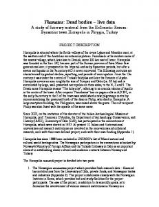
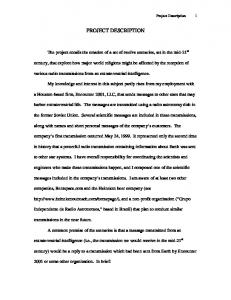
Estimated mineral reserves and economically viable mineral resources are listed Table 2.1 for both Wabush 3 and the other IOC ore bodies. The Wabush 3 deposit currently only contains mineral resources (i.e., no mineral reserves). Further engineering studies, including geotechnical, hydrogeological and infrastructure assessments, are required before these resources can be converted to reserves. Mineral resources in all IOC ore bodies are constrained by an economic assessment of the mineralisation using estimated long term iron ore prices (i.e., lower than current spot prices). This economic assessment uses all mineral resource categories (i.e., measured, indicated and inferred resources) and is carried out with widely used pit optimisation software (Whittle). A preliminary pit design has been prepared based on this economic assessment, which captures approximately 90% of the Wabush 3 resource. There is some potential for a moderate extension of the pit to the south if long term prices are higher than anticipated, but thinning of the southern extensions of the ore body limits this potential. The pit design is based on geotechnical parameters from IOC‟s operating pits. A detailed geotechnical assessment of the Wabush 3 area will be carried out prior to finalising pit designs. No significant slope design changes are anticipated for the foot wall slopes, but hanging wall and end wall slopes may change as a consequence of the geotechnical studies. Current plans develop the pit in three large phases. The phased development of the pit commences near the outcrop of the syncline (at the north end of the orebody) and progresses down dip to the south. Production schedules have been developed using the material inventory of this preliminary pit design. A preliminary mining schedule for Wabush 3 has been developed, to produce approximately 20 Mtpa of ore. Figure 2.7 shows the ore and waste to be mined for the next 40 years from Wabush 3 and the other IOC pits in this schedule. Figure 2.6 shows the corresponding ore qualities (iron grade and magnetite grade). Mining is scheduled to commence in 2018, but earlier development with seasonal mining in 2016 and 2017 would be desirable, if it can be achieved (Figure 2.14). The Wabush 3 pit is large and could, potentially, be mined at a very high rate. It is, however, being mined in conjunction with a number of other pits and the optimal mining rate will depend on the characteristics of the other pits with which it is being co-mined. Wabush 3 has a low strip ratio, particularly for the first phase, so it will be used, at least in part, to offset high strip ratios on other pits (e.g., Humphrey South). Further work is required to optimise the development sequence, so the final mining rate for Wabush 3 may vary from that shown in Figure 2.7. To produce 23 Mtpa of concentrate, IOC will need approximately 54 Mtpa of iron ore mined from existing and planned open pits. The potential sources of ore are - the existing operating open pit mines (Luce, Sherwood, Humphrey Main, Humphrey South and Lorraine South), pit to be reactivated (Spooks) and Wabush 3 (Figure 2.2).
IOC Proposed Wabush 3 Project • EA Registration and Project Description • May 2013
Page 13
Table 2.2 IOC - Sources of Iron Ore Operating Humphrey Main
Sherwood Pond
Humphrey South
Lorraine South
Spooks
Wabush 3
Wabush 6
Reserves
Probable
Resources
Measured
386
156
25
164
17
15
-
-
763
%Fe
36
39
42
39
38
43
-
-
38
Total
Mt
222
242
25
64
0
3
-
-
557
%Fe
37
38
39
38
37
44
-
-
38
Mt
40
30
7
104
19
18
253
119
590
%Fe
36
41
41
41
40
39
38
37
38
Mt
78
231
19
74
1
73
595
601
1,672
%Fe
37
40
42
40
39
43
38
37
38
Mt
52
323
12
187
0
19
55
178
825
%Fe
36
39
41
39
41
41
38
35
38
Reserves Only
24
20
5
16
2
2
-
-
26
Reserves + Meas & Ind Resources
31
49
9
35
4
13
45
45
69
Indicated Inferred
Approx Mine Life (years)
New
Mt
Deposit
Proven
Dormant
Luce
Status
1. 2.
Mineral Resources exclude Mineral Reserves. Reserves and resources have been estimated by Tim Leriche, Mark Blake and David Blechynden, who meet the criteria for being Qualified Persons, as defined by Nation Instrument 43-101 and who are all full time employees of IOC.
3.
Reserves and resources comprise all mineralised material within the Middle Iron Formation of the Sokoman Formation, except limonitically altered material. No cut-off grade has been applied within the Middle Iron Formation, since all mineralised material is economically viable (above 20% weight yield). Current operating practice at IOC is to process all mineralised material from the Middle Iron Formation.
4.
Mr Blake is responsible for the development of the orebody models used to estimate the above reserves and resources. In this capacity, he has verified the data used to develop the reserve and resource estimates. Most of the assays and density determinations used in the reserve and resource estimates have been carried out by the IOC laboratory. QA/QC protocols have been in place since th 2004. Assay standards are inserted after each 12 sample and duplicate assays are carried out on th every 50 sample. A limited number of twinned holes have been compared to validate the assays from holes drilled before the commencement of the QA/QC program. Mr Blake has reviewed the sampling protocol and validated the chain of custody of samples on an ad-hoc basis, although this is not part of the routine QA/QC process. Reconciliations of modeled ore tonnes and qualities against measured tonnes and qualities are carried out monthly, to validate the reserve models.
5.
Wabush 6 is a resource that is located between Luce Pit and Wabush Lake. There are currently no plans to develop Wabush 6 within the next ten years. Its development and the timing of such will require further analysis. It therefore is not considered to be a project related to Wabush 3 Project.
IOC Proposed Wabush 3 Project • EA Registration and Project Description • May 2013
Page 14
45%
40%
35%
30%
25% Grade
Wabush3 - Iron (%) Other pits - Iron (%)
Wabush3 - Mag (%)
20%
Other pits - Mag (%)
15%
10%
5%
0% 2018 2020 2022 2024 2026 2028 2030 2032 2034 2036 2038 2040 2042 2044 2046 2048 2050 2052
Figure 2.6 Wabush 3 Project - Ore Quality 140
120
Material Mined (Mt)
100
80 Other Pits - waste Wabush3 - waste
Other Pits - ore 60
Wabush3 - ore
40
20
0 2013 2015 2017 2019 2021 2023 2025 2027 2029 2031 2033 2035 2037 2039 2041 2043 2045 2047 2049 2051
Figure 2.7 Wabush 3 Project - Material To Be Mined
IOC Proposed Wabush 3 Project • EA Registration and Project Description • May 2013
Page 15
The operational pits and the one planned for reactivation have all been submitted to various levels of assessment and permitting and are not part of the Wabush 3 Project Registration /Project Description. Mine planning for the reopening of Spooks pit is ongoing. They are discussed here simply to demonstrate that Wabush 3 is intended to be an expansion of a single existing operation and not a new mining undertaking.
2.4.2
Wabush 3 Open Pit Mine Development and Operation
The Project will consist of the following components:
an open pit mine which contains an estimated 900 M tonnes of iron ore and has an estimated operating life of 40 years. This could vary significantly, depending on the actual mining rate;
an overburden storage area to the south of the open pit and dissected by an existing gravel road which also dissects the open pit footprint;
a waste rock disposal site, adjacent to and northwest of the open pit;
a haulage road to the northeast of the open pit, linking the open pit with existing ore conveyor and concentrator facilities;
a haulage road to the west of the open pit, connecting the open pit to the waste rock storage pile;
a haulage road to the south of the open pit, connecting the open pit to the overburden storage area;
a pole line to twin the haulage road to the northeast of the open pit;
a groundwater extraction system; and
a mine water collection, treatment and disposal system.
The overall Wabush 3 Project area (including the mine pit, waste rock disposal area, overburden storage area and haulage roads) will cover a total area of approximately 464 ha (Figure 2.4).
IOC Proposed Wabush 3 Project • EA Registration and Project Description • May 2013
Page 16
Table 2.3 Wabush 3 Pit – Estimated Resources and Materials* Iron Ore / Waste Rock / Overburden
Million Tonnes
Phase 1 (Years 1 - 16)
Phase 2 (Years 17 - 28)
Phase 3 (Years 29 - 40)
Iron Ore
850
325
280
245
Waste Rock
450
70
160
220
Overburden
28
16
6
6
Total Material Moved
1,328
411
446
471
* Based on measured and indicated resources. Inferred resources make up the remaining 50 mt.
The Project will be developed in four phases that will include a mix of site development, operations and decommissioning.
Phase 1 will include the construction of the haulage roads, the clearing and use of the waste rock disposal site and overburden storage area, overburden and waste rock removal in the northern section of the pit, the mining of the northern section and the installation of groundwater extraction wells within the open pit footprint. Mine dewatering will occur through a settling and treatment system and into the Dumbell Lake watershed (Figure 2.13). This will occur during years 2 – 16.
Phase 2 will include the extension of the pit into the central section with overburden clearing, waste rock removal, mining in the northern and central sections and the installation of groundwater extraction wells outside the southern edge of the open pit footprint. Mine dewatering will be relocated and will occur through a settling and treatment system and into the Leg Lake watershed. This will occur during years 17 – 28.
Phase 3 will include the extension of the pit into the southern section with overburden clearing, waste rock removal and mining in all sections and the completion of the installation of groundwater extraction wells outside the southern edge of the open pit footprint. Mine dewatering will continue as per Phase 2. This will occur during years 29 – 40.
Phase 4 will include site closure and rehabilitation. Closure will occur after completion of the mining activity, sometime after year 40. The IOC site Closure Plan will be amended to include the Wabush 3 operation with the next update (updates are normally conducted every five years). Progressive rehabilitation will be an important factor in the amended Closure Plan and will be implemented where possible during the earlier phases.
Figure 2.4 shows the approximate boundaries of the three phases of mine development and Figure 2.14 shows the approximate locations for the installation of groundwater extraction systems. Figures 2.8, 2.9, 2.10 and 2.11 show the current design layout for the Wabush open pit at years 5, 15, 25 and completion in year 40. The drawings show the progression of IOC Proposed Wabush 3 Project • EA Registration and Project Description • May 2013
Page 17
development from the northern through to the southern sections of the pit. Mine activity along the eastern face of the pit, closest to the Smokey Mountain ski hill, will occur early in the pit development and continue for the first 10 – 16 years. The mine extension into the central section will require the removal of Pumphouse Pond and Drum Lake, sometime near year 16. Compensation associated with loss of fish habitat will be required prior to then. IOC will prepare, in consultation with DFO at an appropriate time prior to extension into the central section, a Compensation Plan which will comply with DFO requirements at that time. It is recognized that DFO‟s policies and approaches to dealing with fish habitat loss are currently under review.
IOC Proposed Wabush 3 Project • EA Registration and Project Description • May 2013
Page 18
Figure 2.8 Wabush 3 Project - Plan View of Wabush 3 Open Pit at Year 5 of Development
IOC Proposed Wabush 3 Project • EA Registration and Project Description • May 2013
Page 19
Figure 2.9 Wabush 3 Project - Plan View of Wabush 3 Open Pit at Year 15 of Development
IOC Proposed Wabush 3 Project • EA Registration and Project Description • May 2013
Page 20
Figure 2.10 Wabush 3 Project - Plan View of Wabush 3 Open Pit at Year 25 of Development
IOC Proposed Wabush 3 Project • EA Registration and Project Description • May 2013
Page 21
Figure 2.11 Wabush 3 Project - Plan View of Wabush 3 Open Pit at Year 40 of Development (Mine Completion)
IOC Proposed Wabush 3 Project • EA Registration and Project Description • May 2013
Page 22
Figures 5.4, 5.5, 5.6 and 5.7 present computer generated 3-Dimensional visuals of the depleted Wabush 3 pit and its waste rock pile as seen from different vantage points. The visual environment perception of the site in 2058 (40 years of operation) is described in Section 5.5.6 – Viewscapes and Visual Aesthetics.
2.4.3
Overburden Handling
Overburden associated with the open pit consists of vegetation and underlying soil and organic material. Its removal will occur in three time frames and in keeping with the three phases of the pit development. The site preparation for the waste rock disposal site and the overburden storage site will consist of partial clearing of trees and shrubs. The underlying material will not be removed from either site. The haulage roads corridor preparation will include vegetation clearing and road bed establishment, including the removal of unsuitable underlying material. This is discussed in Section 2.4.5. The overburden will be segregated from the waste rock and stored at a site to the south of the open pit which is dissected by an existing gravel road which also dissects the open pit footprint. This material will be stored for future use in rehabilitation of areas of the IOC property. The overburden storage area will be approximately 49 ha. Trees that are cleared from the sites will be salvaged where possible and made available for use within the community, mainly as fuel. The rest of the vegetation will be mulched and mixed with the soil and organic material and trucked to the overburden storage area.
2.4.4
Waste Rock Disposal
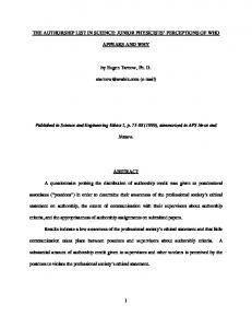
An estimated 450 M tonnes of waste rock will be produced throughout the life of the mine operation with periods of large scale waste rock production, particularly during the three phases of the pit development. The waste rock disposal site is located immediately to the west of the pit and will be connected to the pit by a short haulage road which eventually will be become part of the pile. The footprint area for the waste rock disposal site is estimated at 153 ha, approximately 100 ha of which is Greenfields and the rest is a part of the existing waste rock disposal site on the southern extent of Luce Pit. Its location spans a valley between the pit and the next hillside to the west (Figure 2.4). The methodology for disposal of rock at the site will start with infilling and advancing within the valley, followed by step raises abutting the western hillside and step raises to completion of the mine life. The design of the raises will be such that progressive rehabilitation will be possible upon completion of each raise. The rehabilitation will help with slope stability and with maintaining quality of precipitation and snow melt runoff. The step raises are designed to be 40 m high with an inter-step slope angle equal to the expected angle of natural repose of the material (37°). A 60m wide berm is left between each lift, which allows the slopes to be dozed down to a 20° angle for rehabilitation, with 5m wide berms being left between rehabilitated slopes (Figure 2.12). Decommissioning upon closure of the disposal site will be consistent with IOC‟s Closure Plan and the effort needed will be reduced by the rehabilitation activity that will have preceded closure. The side slope of the waste rock disposal area will be such that run-off will percolate through the rock and not likely have any cascading effects. IOC Proposed Wabush 3 Project • EA Registration and Project Description • May 2013
Page 23
Figure 2.12 Wabush 3 Project - Waste Rock Pile Rehabilitation Slopes The effects of vegetation on the lower steps will be to retain precipitation and reduce the incidences of flash runoff. The waste rock will not be acid generating and the angle of side slopes and anticipated percolation should minimize silt buildup in drainage off the disposal site. Drainage will report to both the Leg Lake and White Lake watersheds and the distance between the edges of the disposal site and both lakes will be long enough to filter out any suspended solids before reaching the lakes. This is the experience gained from existing waste rock disposal sites on the Carol site.
2.4.5
Haulage Roads
Three haulage roads will be constructed. One is approximately four km long and will connect the north-eastern end of the Wabush 3 Pit to the existing Luce Pit infrastructure to the northeast where the ore will receive primary crushing and be loaded on the overland conveyor system for delivery to the existing concentrator facilities. The road will cross through approximately one km of a forested area and then border a disturbed area on the eastern edge of Luce Pit. The section along the Luce Pit edge had been previously developed for Luce Pit activity and will need some widening. The second road will be less than one km long and will connect the north-western end of the pit to the waste rock disposal area to the west. The waste rock haulage road will eventually become part of the pile. The third road is an existing road that dissects the open pit footprint and will connect the open pit to the overburden storage area. It is approximately 2.5 km and will need to be widened.
IOC Proposed Wabush 3 Project • EA Registration and Project Description • May 2013
Page 24
The three roads will be unpaved and will be designed to handle two way traffic of the large haul trucks (275 tonnes) used by IOC. The roads will be 40 meters wide, with a maximum grade of 8 per cent. There will not be any water crossings associated with the roads. Consistent with existing operations, there will be no haulage road lighting. Road maintenance and dust suppression programs will be performed as part of the existing programs. These three roads increase the existing road system on the IOC site by approximately 15 per cent. 2.4.6
Mine Water and Groundwater Extraction - Collection, Treatment and Disposal
The pit dewatering and groundwater extraction operations for the Project will be similar to other nearby IOC mining operations. With a few exceptions, the mine dewatering and treatment of the existing IOC pits over the past 50 years have resulted in minimal effects on the aquatic environment. The area surrounding the pit boundary will be bermed or diverted to prevent additional runoff flow into the pit. The principle objectives for managing inflows into the Wabush 3 open pit are to create and maintain a dry environment for drilling, blasting and excavating iron ore and waste rock, and to reduce adverse effects of groundwater on the development of sinking cuts. These objectives will be accomplished by the following:
Diverting flows around pit areas with diversions,
Collecting groundwater seepage and surface runoff and conveying it into designated sumps within the pits;
Directing inflows away from the active mining areas and into sumps with ditches;
Intercepting groundwater flow with deep dewatering wells;
Maintaining drawn down conditions in the sumps by pumping to sedimentation ponds or other designated discharge sites; and
Treating collected mine water to meeting Federal and Provincial water quality regulations before discharge to the receiving environment.
An environmental benefit of maintaining a dry working area is a reduction in the quantity of blasting emulsion that is flushed or leached from the blastholes. This in turn reduces the amount of ammonia in the pit sump inflows, and ultimately in the mine discharge and receiving water. During the initial stages of mining development and operation, pit dewatering will be performed using gravity drainage of water accumulated in the pit north into a creek leading to a proposed settling pond and eventually into Dumbell Lake (Figure 2.13). Once the bottom of the pit becomes lower than the settling pond, all runoff and groundwater seepage will be drained south towards the Leg Lake system. Initially, accumulated water would be pumped into Pumphouse Pond, the water body within the pit footprint, which will IOC Proposed Wabush 3 Project • EA Registration and Project Description • May 2013
Page 25
provide primary settling. Discharge from Pumphouse Pond would flow naturally through Drum Lake and into Leg Lake. In the Phase 2 development Pumphouse Pond will be removed and will be replaced for mine water treatment with a possible combination of Drum Lake and a constructed settling and treatment system. The design details will be determined with the groundwater modeling results and the experience gained through the early stages of mine development. Depending on the water quality, an alternative would be to pump accumulated pit water to the currently used Luce Lake pit water discharge point. Regardless of which phase of mine development or into which watershed the treated mine water is discharged, the treatment system will be designed and operated to meet the federal and provincial regulatory standards for effluent quality at the points of release (Final Discharge Points) to the receiving environment. Two issues that are favourable to simplifying treatment design and the resultant management of wastewater quality are:
the geology of the area is characterized by non-acid generating (NAG) rock; and
IOC is assessing options for modifying blasting practices, with the intention of providing better control over toxicity associated with ammonia.
The quantity of groundwater that can be encountered during the development and operation of Wabush 3 has not been determined with confidence yet. Extraction of groundwater through the use of boreholes and groundwater pumping will be required, based on hydrogeological knowledge for the Luce Pit area immediately to the north of Wabush 3. Groundwater modeling for the Wabush 3 area will be conducted in 2013 and the results will be used to determine the need and extent of groundwater pumping (extraction). The groundwater modeling will help to estimate quantities and flow rates and this information will be important to design the groundwater pumping and handling systems. Previous hydrogeological investigations (Piteau 2002) of IOC open pit mines north of the Project area have estimated groundwater seepage into each pit for mitigation purposes. Groundwater seepage ranges from as low as 80 USGPM (~440 m3/d) for Humphrey South Pit up to 1,000 USGPM (~5,400 m3/d) for the Humphrey Main Pit. A conceptual, preliminary design of groundwater extraction systems is provided in Figure 2.14. Groundwater extraction wells will be installed within the Wabush 3 footprint during the Phase 1 development. Some of these wells will be installed in advance of any overburden clearing and waste rock removal and some after mining has established suitable areas for development of the wells. During Phases 2 and 3 groundwater extraction systems will be installed outside the pit perimeter along the southern edge of the pit. The exact locations and the number of groundwater extraction systems will be determined after the groundwater modeling is conducted and will likely change as experience is gained from previous systems installed during the life of the Project. The determination of the locations for the groundwater extraction wells will also be aided by drilling programs which will be undertaken within and around the Wabush 3 Pit footprint. Drill holes which encounter the most productive water bearing zones will be selected as the sites for the dewatering wells. The groundwater extraction program will likely be a long-term measure to help mitigate the groundwater seepage into the Wabush 3 pit. IOC Proposed Wabush 3 Project • EA Registration and Project Description • May 2013
Page 26
Transmission lines will be built from the main electrical supply line (built to power the mining equipment) to the wells within the Wabush 3 pit. The effects that the wells will have on the groundwater flow regime in the Wabush 3 area will be assessed using the pumping records and piezometric data. These data will be tracked by hydrogeological personnel within IOC‟s Mine Technical Services group. It is anticipated that most boreholes for groundwater extraction will be placed outside the pit and most of those within the pit will be established before mining activity occurs. Accordingly, the water collected should not be affected by in-pit activities (suspended solids and chemicals associated with blasting) and the need for treatment of the extracted groundwater is not anticipated. Should treatment be determined to be needed, the well discharges will be directed to the pit water treatment system. The quantities, quality and discharge location(s) will be determined during the detailed system design stage. Design of groundwater extraction discharges will be such that erosion protection will be included. The need to determine if these discharge points will be required to be declared as Final Discharge Points under the Metal Mining Effluent Regulations will be determined with Environment Canada during the detailed design stage. Figure 2.15 provides a typical layout for a groundwater extraction site.
2.4.7
Associated Infrastructure
Associated infrastructure will be limited to electrical power supply (power lines and substations) and dewatering systems (pumps and pipelines). The equipment fleet will not increase and existing facilities will provide equipment maintenance and office needs, as well as employee needs (washroom, change rooms, lunchroom and potable water.
Power Demand and Supply The Project involves the development of a new open pit mine, which is to operate in combination with the existing and reactivated open pits. Anticipated power demand for the pit operation is 15 MW. It will be supplied through a connection to the existing power system near the Luce Pit infrastructure site. A pole line will be built along the new haulage road between Wabush Pit and the Luce infrastructure site, approximately four km (see Figure 2.14). An electrical substation will be located near the Wabush 3 pit.
Dewatering Systems The dewatering system is discussed in Section 2.4.6 - Mine Water and Groundwater Extraction - Collection, Treatment and Disposal. A schematic of a typical groundwater extraction system is provided in Figure 2.15 and is based on the experience from the Luce Pit groundwater extraction system. The actual number of wells and their specific locations will be determined after completion of the hydrogeological monitoring and modeling planned for 2013.
IOC Proposed Wabush 3 Project • EA Registration and Project Description • May 2013
Page 27
Figure 2.13 Wabush 3 Project - Initial Settling Pond and Existing Ski Infrastructure Locations
IOC Proposed Wabush 3 Project • EA Registration and Project Description • May 2013
Page 28
Figure 2.14 Wabush3 Project – Potential Groundwater Extraction Locations
IOC Proposed Wabush 3 Project • EA Registration and Project Description • May 2013
Page 29
Figure 2.15 Typical Layout for a Groundwater Extraction Site
IOC Proposed Wabush 3 Project • EA Registration and Project Description • May 2013
Page 30
Communications The existing radio system has a repeater station that is located on a hill between Luce Pit and Wabush 3. This will allow for radio communications between the equipment operators and operations management. There are no further communications needs or infrastructure.
Fuel Supply There will not be any fuel supply or distribution systems located at the Wabush 3 site. Diesel powered trucks will be fueled at existing central facilities. Diesel powered dozers will be fueled in the pit using fuel trucks. All existing Above Ground Storage Tanks (ASTs) are equipped with secondary containment and installed as per the Gasoline and Associated Products (GAP) Regulations, 2003.
Water Supply Potable water will be supplied at the existing facilities which will be used by Wabush 3 operational staff. There will not be a dedicated fire suppression water supply. Response to any fires in the pit will be with dry chemical systems and IOC‟s existing fleet of water trucks and fire engines. These trucks would be filled from existing standpipes and standpipes that will be established near the Wabush 3 pit dewatering system. The pit standpipes will enhance the efficiency of the use of the water trucks for dust suppression and will also be beneficial for fire suppression.
2.5
Construction/Development
General construction activities for the Project, including groundwater extraction, will include:
overburden clearing;
construction of infrastructure;
installation of utilities; and
commissioning.
The first phase of construction will be the construction by IOC Operations of an unpaved haulage road from the Luce Pit infrastructure area to the north-eastern section of the Wabush 3 pit. It is approximately four km long and follows the eastern edge of the Luce Pit on mostly disturbed ground and finishes along an approximately one km length through a forested area. A pole line for power delivery to the Project will be built along the haulage road corridor. The section along the Luce Pit edge had previously been constructed and will need some upgrades only. There are no water crossings associated with the road. Standard and relatively routine road construction methods will be used in its construction. IOC Proposed Wabush 3 Project • EA Registration and Project Description • May 2013
Page 31
Any materials needed for the road bed will be obtained from either existing waste rock stockpiles, existing quarries on the IOC property or from off-site quarries owned and operated by third party contractors. The stockpiling of overburden material will occur at a location to the south of the open pit. This location is dissected by an existing unpaved road which also dissects the open pit. The road will need to be widened during the first phase, also by IOC Operations. The short haulage road to the waste rock pile will be constructed at a later time as its use will not be needed during the early clearing activity. Overburden associated with the open pit consists of vegetation and underlying soil and organic material. Its removal will start in the first phase of construction and occur during the May – October timeframe each year to stay in advance of the subsequent waste rock removal. Overburden removal will be associated with each of the three phases of the pit development. The site preparation for the waste rock disposal site will consist of partial clearing of trees and shrubs and will occur over several years, but will be completed fairly early in the 40 year mine life. The timing for the waste rock site clearing is to allow the higher lifts on the waste rock pile to be built when needed. The underlying material will not be removed. The haulage road corridor preparation will include vegetation clearing and road bed establishment, including the removal of unsuitable underlying material. Throughout the Project‟s 40 year timeframe, approximately 464 ha will be disturbed and approximately 411 ha of this will require clearing. Limits of clearing will be marked prior to commencement, and only designated areas will be cleared. Trees and shrubs will be cleared using chain saws and other hand-held equipment. Mechanical clearing methods may be employed in areas where disturbance will not result in sedimentation of water bodies. Topsoil and organic matter will be stripped and stockpiled for eventual use. This work will include the installation of all necessary sedimentation and erosion control measures, including drainage infrastructure. Any merchantable timber will be salvaged and made available to interested parties. An Environmental Protection and Monitoring Plan will be developed and implemented, consistent with IOC‟s Environmental Management System and compliant with environmental permits, regulations and applicable standards. The initial removal of waste rock covering the ore in the pit will probably be performed using IOC‟s equipment, rather than a contractor. There is very little waste rock to be mined in the initial northern section of the pit before ore is encountered, so there is limited scope for contracting the waste. Conventional mining techniques will be utilized for drilling and recovery and transport of ore. IOC is investigating options for changes to existing blasting procedures used in the other pits, including recommendations contained in a recent draft report received from Blasting Analysis International (BAI), a company with expertise in mining and blasting. Decisions on blasting procedures will be made after extensive technical and community consultation and detailed risk assessment associated with public safety issues regarding the use of the nearby Alpine and Nordic ski facilities. IOC Proposed Wabush 3 Project • EA Registration and Project Description • May 2013
Page 32
IOC currently has in place procedures for the storage, transport and use of fuel and hazardous material, the storage and removal of waste and hazardous waste, and emergency response plans which are implemented at the existing mines and processing facilities. These plans are also applicable to construction activities, both ongoing and planned (see Section 2.14). These procedures and plans and materials handling facilities will be relevant to and available for the Project and will be amended and expanded as needed. Subsequent to release from the EA process, the receipt of formal corporate approval and all other required regulatory approvals and permits; site activities may begin as early as 2015. Such activities would include: overburden removal/gravel stripping, waste rock drilling/blasting/removal, and the construction of the haulage roads, groundwater extraction wells within the pit footprint and the northern settling pond. Construction activities will not disrupt the existing mining operations in any way. In anticipation of a determined need to develop a new cross country ski trail system (to be studied in 2013), its construction would also occur in 2015.
2.6
Operations and Maintenance
The proposed open pit mine and associated facilities and infrastructure will be designed to produce 20 MTPA of run of mine (ROM) iron ore with an average iron content of 36 - 39%. The production rate from Wabush 3 at any given time will be determined in conjunction with production rates from the other operating mines (Table 2.2). The overall production rate of ROM iron ore will match that needed to achieve the rated capacity of the concentrator plant. For a rated capacity of 23 MTPA for concentrate production, the ROM iron ore production is estimated to be 54 MTPA. Wabush 3 mine operations will be based on 24 hour days and 365 days per year.
2.6.1
Open Pit
Ore will be recovered from the open pit using drill and blast methods. Electric shovels (P&H 2800) will load the ore and waste into 275 tonne capacity diesel haul trucks and transport it along a dedicated haulage road to the Luce Pit infrastructure for primary crushing and transfer the ore onto the overland conveyor system which will move it to the existing concentrator plant.
Bench Geometry The open pit excavation will be created using drill and blast methods. Final bench geometries will be based on detailed geotechnical assessment. Preliminary bench geometries (based on current operating practices) are as listed below:
Overburden slopes will be cut in 10 m high benches. The overburden, however, is less than 10 m thick over most of the pit, so the overburden slopes will generally be unbenched;
Footwall slope designs are presented in Table 2.5; and
IOC Proposed Wabush 3 Project • EA Registration and Project Description • May 2013
Page 33
Slope designs for hanging walls and end walls are presented in Table 2.4.
Table 2.4 Preliminary Slope Design for Hanging Wall and End Wall Slopes BENCH GEOMETRY PARAMETER Bench Angle Inter-Ramp Angle Bench Height Bench Width
72 53 41.1 m 18 m
Table 2.5 Preliminary Slope Design for Footwall Slopes BENCH GEOMETRY Bench Angle PARAMETER Inter-Ramp Angle Bench Height Bench Width
30 30 26 41.1 m 12 m
DIP OF BEDDING / STRATA 40 50 40 50 34 41 41.1 m 41.1 m 12 m 12 m
60 60 49 41.1 m 12 m
The design for pit slopes in overburden material is as follows:
Allowance for a water diversion bench at the overburden crest;
Unbenched slope of 3H:1V;
Rationale: 2H:1V is too steep for long term stability without knowing details regarding the overburden; and
Allowance for a safety bench at the interface between overburden slopes and top of bedrock.
Operational activities at the open pit will include:
Control of precipitation and groundwater – in-pit sumps and pit-perimeter dewatering wells (if needed and to be determined in 2013 with additional information from hydrogeological monitoring and modeling) will be used to control water entering the pit. Collected in-pit water / effluent will initially drain to a settling pond to the northeast of the pit (Figure 2.13) and later, after the pit floor is below the setting pond, will be pumped to an engineered settling pond to the southwest of the pit for treatment of suspended solids and residual chemistry from blasting operations prior to release to the receiving environment. Water from any pit-perimeter dewatering wells will not likely be affected by pit suspended solids or chemicals associated with blasting. Accordingly, the need for treatment of the extracted groundwater is not anticipated. The quantities, quality and discharge location(s) for the pit-perimeter water will be determined during the detailed system design stage. All treatment systems will be designed to comply with federal and provincial water quality standards.
IOC Proposed Wabush 3 Project • EA Registration and Project Description • May 2013
Page 34
Haulage road maintenance – snow clearing and traction control (gravel) will be required as well as dust suppression (water). Occasional grading and leveling of the road will be required.
Diversion ditching – surface runoff diversion ditching will require regular inspection and occasional maintenance, cleanout and grading. Diverted water will be pumped to an effluent treatment system (settling pond), if needed, prior to release.
Dust Suppression – in addition to dust associated with haulage roads, dust will be suppressed at the open pit and other exposed areas as required. Wet drilling will be used in the pit year round for blasting preparation. Dust associated with blasting will be monitored and blasting plans will be adjusted to minimize dust emissions from the pit.
2.6.2
Waste Rock Disposal Areas
The proposed Wabush 3 mining plan is expected to generate approximately 450 MT (140 M m3) of waste rock over the mine life. It is estimated that the waste rock volume will swell by 25% due to bulking during excavation and placement. It is also understood that the resource estimates can change as mine development, ongoing testing and pit optimizations are ongoing. To permanently store the anticipated volume of waste rock produced by the development of Wabush 3, a conventional surface waste rock disposal area is proposed. The location, size and topography of the disposal area are described in Section 2.4.4. The methodology for disposal of rock at the site will start with infilling and advancing within the valley, followed by step raises abutting the western hillside and step raises to completion of the mine life. The design of the raises will be such that progressive rehabilitation will be possible upon completion of each raise.
2.6.3
Maintenance and Response Procedures
The proposed open pit mine and associated facilities and infrastructure, during development and operation, will be subject to regular inspection and maintenance, which will help to prevent any leakage, spills or other unplanned discharges to the environment. IOC currently has in place procedures for the storage, transport and use of fuel and hazardous material, the storage and removal of waste and hazardous waste, and emergency response plans which are implemented at the existing mines and processing facilities (see Section 2.14). These procedures and plans and materials handling facilities will be relevant to and available for the Project and will be amended and expanded as needed. IOC has a proven track record over its 50 years of operation of the Carol Project in efficient operations and proactive, preventative maintenance programs. IOC has operated through this period with very few upsets in mining and milling that have resulted in environmental effects or damage.
IOC Proposed Wabush 3 Project • EA Registration and Project Description • May 2013
Page 35
2.7
Closure and Decommissioning
The Project will be operated on a permanent basis for the life of the resource, estimated to be 40 years or longer depending on mining rates. The future decommissioning and remediation of the Project facilities will be incorporated into the overall IOC Closure Plan for its Labrador West mining operations. Should decommissioning be required for Wabush 3 in advance of any larger closure initiative, a detailed decommissioning plan would be developed and implemented in accordance with acceptable standards of the day, and in consultation with relevant regulatory agencies. There are no current facilities or operations that will be closed or altered that would require decommissioning associated with the Wabush 3 Project.
2.8
Possible Accidents and Malfunctions
In the construction, operation and maintenance of the Project, an accidental or other unplanned event is an unlikely, but unfortunately possible, outcome. Some of the potential accidental events or malfunctions that may be associated with the Project and which are relevant for EA purposes include:
a fire at the facility, potentially extending into adjacent areas and communities; and
an accidental spill of chemicals, fuels or other deleterious substances into the terrestrial and/or aquatic environments.
Human health and safety and environmental protection will be paramount considerations by IOC in the planning and design of the Project, and these will continue to be the main priority during construction and operation. IOC has significant and long-term experience in all facets of iron ore mining and processing in Labrador West, dating back to the early 1960s. There are comprehensive Health, Safety and Environmental Management Systems and associated plans and procedures in place. These will be adopted and updated as required for the Project, which will be designed, constructed and operated in compliance with relevant legislation, regulations, standards and guidelines.
2.9
Effects of the Environment on the Project
Topographic features, climatic conditions, adjacent water bodies, hydrogeological conditions, potential for acid generation and other environmental factors have and will, to varying degrees, influence the design of the Project and its associated components. Such components would include access ramps, haulage roads and mine water collection, pumping and treatment systems. While the results of studies and modeling of the surface and groundwater effects on the mine development and operation have not been completed, IOC has demonstrated an ability to operate open pit mines in the general proximity of Wabush 3 over the past 50 years in a safe and environmentally compliant IOC Proposed Wabush 3 Project • EA Registration and Project Description • May 2013
Page 36
manner. The results of the studies which are presently being conducted will influence the detailed design of Wabush 3. Another factor being considered is the proximity of winter recreational areas (the Smokey Mountain ski hill, the Menihek Nordic Ski Club and the White Wolf Snowmobile Club) to the Project and the effects on mine design associated with their coexistence with the mine. IOC is planning mitigation measures, including studies and blasting practices evaluations and assistance to the recreational organizations to relocate some or all of their facilities, if needed. This is discussed further in Sections 3 and 5. Weather conditions will also likely influence the timing of some construction activities.
2.10
Project Schedule
The construction or site development will continue and phase in with the mine operations after the first 13 months of initial development. A Preliminary Project Schedule, assuming Environmental Assessment requirements are completed by early 2015, has been prepared that would see mine development begin as early as 2015 (Figure 2.14). The Schedule also provides for the ground water extraction activities – hydrogeological testing and assessment (modeling), system design, pump procurement, well construction and groundwater extraction operation. The Schedule provided is limited to the design, procurement, construction and start-up phases of the Project. Project decommissioning, rehabilitation and closure will occur after the mine is depleted which is currently envisioned to be after 40 or more years of operation, beyond 2058. The schedule and approach to closure will be developed at a later time when the mine closure can be more accurately determined and will reflect the Closure Plan requirements of the Provincial government at that time and will also the amount of progressive rehabilitation that will have occurred up to that point.
2.11
Labour Force and Occupations
The Project, through its construction and operations phases, will result in positive economic effects for IOC and the community. Employment opportunities will be realized during the construction/development phase of the Project where components of this work (extension of the power line, installation of electrical sub-stations, drilling of dewatering wells, installation of dewatering pipelines, excavation of a settling pond, clearing, gravel stripping and initial drilling and blasting) will be contracted to third parties. The construction of the haulage road and the mine operations phase will be conducted using the current IOC workforce. Because the operation of the Wabush 3 pit will not result in increased production of ore or final product, existing staff will be deployed from other mines operations. Consequently, there will be no net increase in operations employment. Project construction will be carried out on a contractual basis, with workers hired at the discretion of the contractor and in accordance with its own hiring practices and policies.
IOC Proposed Wabush 3 Project • EA Registration and Project Description • May 2013
Page 37
2013 Q1
Q2
2014 Q3
Q4
Q1
Q2
2015 Q3
Q4
Q1
Q2
2016 Q3
Q4
Q1
Q2
2017 Q3
Q4
Q1
Q2
2018 Q3
Q4
Q1
Q2
Q3
Q4
J F M A M J J A S O N D J F M A M J J A S O N D J F M A M J J A S O N D J F M A M J J A S O N D J F M A M J J A S O N D J F M A M J J A S O N D Environmental Assessment and Approvals Environmental Baseline Studies (if needed) Project Registration-Project Description Submission Anticipated Govt decisions on level of EA EA documents prepared Anticipated EA Release Receipt of Govt Permits, C of As and Authorizations Field Work Hydrogeological Testing Blasting Trials Geotechnical Drilling Program In-fill Drilling Program Study Program Hydrogeological Assessment Blasting Studies Geotechnical Studies Pit Design and Mining Schedule Power Reticulation Plan Cross Country Ski Trail Study Downhill Skiing Study Order of Magnitude Study Pre-feasibility Study Feasibility Study Rio Tinto/IOC Approvals Pre-feasibility Study Approval Feasibility Study Approval Project Approval Engineering Electrical Reticulation Design Ski Hill Infrastructure Engineering (as necessary) Cross Country Ski Trail Design Ground Water Extraction System Design Procurement Electrical Equipment Procurement Ski Infrastructure Procurement (as necessary) Ground Water Extraction Pump Procurement Construction Gravel Stripping Development Drill & Blast Electrical Reticulation Installation Haul Road Construction Cross Country Ski Trail Construction Downhill Ski Infrastructure Construct (as necessary) Ground Water Extraction Well Construction Settling Pond Construction Production Ore and Waste Mining Ground Water Extraction
Figure 2.16 Wabush 3 Project - Project Schedule
IOC Proposed Wabush 3 Project • EA Registration and Project Description • May 2013
Page 38
IOC is committed to employment and gender equity in its hiring and contracting practices, and is committed to maximizing the use of the local workforce and Newfoundland and Labrador companies to the extent possible. IOC expects the same commitment from its contractors.
Construction Employment Table 2.6 Estimated Construction/Development Phase Employment Discipline
Position
NOC Code
Civil (Excavation/Backfill)
Heavy equipment operator
7371
27
Driller/Blaster
7372
15
Operator Foremen
7371
3
Carpenter
7271
3
Labourer Foremen
7611
3
Labourer
7611
6
Electrical Foremen
7242
3
Concrete
Electrical
Number of Employees
Electrical Journeymen
7242
6
Mechanics
Heavy-duty Equipment Mechanic
7312
9
Crane Operator
Crane Operator
7521
3
Total Construction Tradespersons Administration and Project Manager Salaried Employees H&S Coordinators
78 0711
1
2264
4
Procurement/Purchasing Staff
1524
1
Project Engineers
0211
1
Field Engineers
2131
2
Junior QA/QC Inspectors Survey Leads
2131 2131
2 2
Total Site Staff
13
Construction/Development Total
91
An estimated 91 workers will be required over the approximate six years of construction/development, spread over the three phases of development. Occupations during the construction/development phases, including NOC-2006 codes, are provided in Table 2.6. Certain positions, such as management, will be required throughout the construction phases, while others will be required for shorter periods of time.
Operations Employment Once commissioned the Wabush 3 Project operations will require an estimated 76 employees in long-term positions. Occupations during the operations phase, including NOC-2006 codes, are IOC Proposed Wabush 3 Project • EA Registration and Project Description • May 2013
Page 39
provided in Table 2.7. As stated above, these positions will not constitute new hires but will be redeployed from other mines within the Carol operation. Table 2.7 Estimated Operations Phase Employment Discipline
Position
Open Pit Hourly Employees
Shovel / Loader Operator Haul Truck Operator Drill Operator include RC Wheel Dozer Operator Track Dozer Operator Grader Operator Water Truck Operator / Snow Plow / Sanding Other Auxilliary Equipment
NOC Code 7421 7411 7372 7421 7421 7421 7411 7421
Operations Total
Number of Employees 8 32 12 4 8 4 4 4 76
The Wabush 3 Project will make a strong contribution to local and provincial economies as a result of this employment and business activity.
2.12
Wabush 3 Project Documents
In addition to this Project Registration/Description and a Summary Document to satisfy the CEAA process, a series of environmental studies were conducted for IOC to assist in preparing for the Wabush 3 Project. These unpublished reports are included as references in this document. The proposed Project area has not been subject to a regional environmental study.
2.13
Wabush 3 Project Cost and Funding
The Project will be funded entirely by IOC. Government financial assistance is not required or being requested. The capital cost for the Project development and construction is estimated to be in excess of $250 million.
2.14
Environmental Management and Protection
The Project will be constructed and operated as part of on-going and long-standing work programs associated with IOC‟s Labrador West operations. The company has in place a comprehensive Health, Safety and Environmental Management System and associated environmental plans and procedures for its development and operational activities. These have been developed and are being implemented and continuously updated in accordance with its corporate Health, Safety, Environment and Quality Policy (Appendix B), other relevant corporate requirements and guidelines, and with a view to meeting, and seeking to surpass, the provisions of applicable legislation and regulations.
IOC Proposed Wabush 3 Project • EA Registration and Project Description • May 2013
Page 40
As part of its existing systems and processes, IOC has in place a comprehensive environmental management system (EMS) certified to the ISO 14001 Environmental Standard, including various associated plans and procedures designed to avoid or reduce the environmental effects of its activities. The Project will be constructed and operated in accordance with applicable legislation and regulations, including the environmental protection and planning measures defined through this EA review, and in compliance with IOC policies, procedures and standards. Table 2.8 provides a listing of some of IOC‟s existing environmental and other plans for its Labrador West development activities and operations. A review and update as needed of these and other existing procedures will be carried out as Wabush 3 Project planning and implementation progresses, including the incorporation of Wabush 3 Project activities into IOC‟s overall integrated management system. Table 2.8 IOC Environmental Management Plans (Current to January 2013) Environmental Management Plans Closure & Rehabilitation of Disturbed Landscapes
Waste Disposal-Obsolete Mobile Equipment & Fuel Storage Systems
Contaminated Soils Management
Waste Disposal-Rail Ties & Electrical Poles
Dewatering-Pits & Lakes
Waste Disposal-Septic Wastes
Environmental Reporting
Waste Disposal-Conveyor Belt
Fugitive Dust Management Operations
Waste Disposal-Used Oil
Groundwater Monitoring for Contamination
Waste Disposal-Used Tires
Glycol-Handling
Waste Rock Dumps - Design of New Landforms
Halocarbons-In Use Equipment
Waste Segregation - General Requirements
Land Disturbance - Vegetation Clearing & Grubbing
Waste Storage Facility Management
Landfill-Operations & Maintenance
Waste Truck Operations
MMER Final Discharge Point Monitoring Program
Spill Kit Maintenance & Inspection
Oil Water Separator Management
Installation of a Temporary Facility
Land & Watercourse Disturbance - Site Clearance Permits
IOC Labrador City Contingency Plan Environmental Releases IOC Labrador City- Operations - Operational Environmental Protection Plan Effluent/Discharge Release MMER Emergency Response Plan
Spill Response Trailer Inspection
Air Quality Control Management Plan
Steam Bay Grit Pit Management
GHG Emissions Management Plan
Storage of Liquid Chemicals - Bulk Tanks
Hazardous Materials & Contamination Control Management Plan
Vacuum Truck Operations
Non-Mineral Waste Management Plan
Waste Disposal-Acid Batteries
Mineral Waste Management Plan
Waste Disposal-Electrical Equipment Containing Oil
Land Use Stewardship Management Plan
PCB's-Testing & Inventory of In-Use Equipment Spill Response & Reporting
IOC Proposed Wabush 3 Project • EA Registration and Project Description • May 2013
Page 41
Table 2.8 IOC Environmental Management Plans (Current to January 2013) Environmental Management Plans Waste Disposal-Fluorescent Light Tubes & Ballasts
Water Use & Quality Control Management Plan
2.14.1 Environmental Protection Plan(s) Environmental protection planning is an integral part of IOC‟s construction, operations and maintenance programs. As a corporation with significant experience in constructing, operating and maintaining mining related infrastructure and activities in Labrador West and elsewhere, IOC has state-of-the-art and proven policies and procedures related to environmental protection and management which will be implemented during the construction and operation of the Project. An Environmental Protection Plan (EPP) is an important tool for consolidating environmental information and procedures in a format that provides sufficient detail for the implementation of environmental protection measures in the field. An EPP provides concise instructions to personnel regarding protection procedures and descriptions of techniques to reduce potential environmental effects associated with any construction or operations activity. IOC has developed and implemented EPPs for the previous phases of its Labrador West development activities, and these will be updated and expanded as required to address the proposed components and activities associated with the Project. An outline of IOC‟s current operational EPP is provided below, for illustration and general information.
IOC Proposed Wabush 3 Project • EA Registration and Project Description • May 2013
Page 42
Table 2.9 Labrador City Operational Development Environmental Protection Plan IOC Labrador City Operational Development Environmental Protection Plan (Revision: December 2010) 1.0 Introduction
2.0
3.0
4.0
5.0
6.0 7.0 8.0
1.1 Purpose of the Environmental Protection Plan 1.2 Environmental Protection Plan Organization 1.3 Roles and Responsibilities 1.4 Environmental Orientation Project Overview 2.1 Construction 2.2 Operations 2.2.1 Ongoing Site Preparation Activities 2.2.2 Mining Activities at IOCC (typical) 2.3 Decommissioning Regulatory Requirements and Commitments 3.1 Approvals, Authorizations and Permits 3.2 Compliance Monitoring 3.3 Reporting 3.3.1 Internal Communication 3.3.2 External Communication Environmental Protection Procedures 4.1 Marshalling and Storage Areas 4.2 Clearing Vegetation 4.3 Grubbing and Disposal of Related Debris 4.4 Erosion Prevention and Siltation Controls 4.5 Buffer Zones 4.6 Blasting 4.7 Watercourse Crossings 4.8 Development Site Water Body Discharge. 4.9 Equipment Use and Maintenance 4.10 Storage, Handling and Transfer of Fuel and Other Hazardous Material 4.11 Solid Waste Disposal 4.12 Mineral Waste Rock and Overburden 4.13 Vehicle Traffic 4.14 Dust Control 4.15 ATV and Snowmobile Traffic 4.16 Hazardous Waste Disposal 4.17 Road Maintenance 4.18 Trenching 4.19 Surveying 4.20 Public Traffic and Activities Contingency Plans 5.1 Culvert Failure 5.2 Road Washout 5.3 Fuel and Hazardous Material Spills 5.4 Wildlife Encounters 5.5 Forest Fires 5.6 Discovery of Historic Resources Environmental Protection Plan Control Revisions Contact List Reference Material
Appendix A List of Abbreviations and Acronyms Appendix B Controlled Copy Distribution List Appendix C Revision Request Form Appendix D Revision History Log
Appendix E DFO Fact Sheets for the Protection of Freshwater Fish Habitat in Newfoundland and Labrador IOC Proposed Wabush 3 Project • EA Registration and Project Description • May 2013
Page 43
Depending on construction sequencing, one or several activity-specific EPPs would be prepared and implemented for the construction phase of the Project. As appropriate, each EPP will include procedures and measures relating to such activities as vegetation clearing, grubbing and grading, storage and handling of fuel, dust control, waste and sewage disposal, work in or near water, contingency plans for unplanned events such as spills, rehabilitation and compliance monitoring. Similarly, EPPs for the Wabush 3 operations will also be developed and implemented.
2.14.2 Emergency Response and Reporting Plan(s) IOC proactively identifies potential emergency situations and develops Emergency Response and Reporting Plans, the purposes of which are to identify responsibilities and procedures in the event of unplanned incidents, such as incidents that may affect human health or safety or the accidental release of hazardous materials, and to provide the information and procedures required for the effective response and reporting of such incidents. An outline of IOC‟s current Contingency Plan for Environmental Releases is provided below, for illustration and general information. Table 2.10 Labrador City Contingency Plan For Environmental Releases IOC Labrador City Contingency Plan For Environmental Releases (Revision: January 2011) IOC Health, Safety and Environment Policy Appendices Purpose 1.0 Definitions 2.0 Potential Spill Types 3.0 Petroleum Based Products 3.1 Land Based Spills 3.1.1 Response, Reporting and Follow-up 3.2 Spills Occurred on Water 3.2.1 Response, Reporting and Follow-up 4.0 Chemicals and Dangerous Goods 4.1 Poly-chlorinated biphenyls (PCB) 4.1.1 Response, Reporting and Follow-up 4.2 Other Chemicals 4.2.1 Response, Reporting and Follow-up Appendix A External Emergency Contacts Appendix B Emergency Call-out Procedure Appendix C Hazardous Waste Collection Points Appendix D Revision History Appendix E Plan Holders
There are comprehensive incident prevention, response and reporting plans and procedures in place for IOC‟s overall Labrador West mining operations. These will be adopted and updated as required for the Project, which will be designed, constructed and operated in compliance with relevant legislation, regulations, standards and guidelines.
IOC Proposed Wabush 3 Project • EA Registration and Project Description • May 2013
Page 44
IOC has established a Business Resilience and Recovery Program (BRRP) that has identified high emergency risks and has developed detailed plans to mitigate. The BRRP is to ensure that the appropriate resources and incident response plans are prepared, practiced and available. The plans provide an effective response for the mitigation, control and recovery from incidents which can affect or disrupt the business at IOC. Activities associated with the Project will be evaluated under BRRP. The BRRP is routinely tested and audited to ensure it meets the ongoing needs of IOC.
2.15
Other Required Environmental Approvals
In addition to approval or release under the provincial and federal EA processes, the Project will also require a number of other permits and authorizations. A listing of the main permits, licences, approvals and other authorizations that may be required for the Project is provided as Appendix C.
IOC Proposed Wabush 3 Project • EA Registration and Project Description • May 2013
Page 45
3.0
EXISTING ENVIRONMENT
The following section describes the physical, biological and socio-economic environments within the area potentially affected by the Project.
3.1
Natural Environment
3.1.1
Climate
The Labrador City-Wabush Area has a continental, subarctic climate with cool, short summers and long, cold winters. Climate information for the Project area presented in Table 3.1 is based on data recorded from 1971-2000 at the Wabush Airport climate station (Climate ID: 8504175). The Project area, at an elevation of 820-840 meters above sea level (MASL) is located approximately 8 km northwest of the Wabush Airport, which is located at an elevation of 551 MASL. Table 3.1 Wabush Lake Airport Climate Normals (1971-2000) Parameter
Unit
Rainfall
mm
0.5
Snow
cm
66.4
Precipitation
mm
54
C
kPA
Average Temperature Average Vapour Pressure
o
Jan
Feb
Mar
Apr
May
Jun
Jul
1.6
3.1
12
48.7
64.8
53
40
82
112
17
2.6
0
41.7
57.4
57
56
85
112
-23
-21
-14
-4.6
3.6
10
0.1
0.1
0.2
0.3
0.6
0.9
Aug
Sep
Oct
Nov
Dec
Year
95
89
37
0.1
6.8
42
6.8
2.9
482.6
75
70.2
445.9
95
96
74
68
56.8
851.6
13.7
12
6.8
-0.4
-8.6
-19
-3.53
1.1
1.1
0.8
0.5
0.3
0.2
0.52
Source: Environment Canada Weather Office http://climate.weatheroffice.gc.ca/climate_normals
The overall average monthly temperature in the area is -3.5°C. The average monthly temperatures from October to April are below zero, ranging from -0.5 to -27°C. Average monthly temperatures from May to September range from 3.6 to 13.7°C (Environment Canada 2012a). While the climate normals show monthly averages of daily temperatures to be below freezing from October to April, temperatures do fluctuate above freezing and rainfall has been recorded in all months of the year. Similarly snow has been recorded at the Wabush weather station in all months except July. Monthly precipitation ranges from 56 to 112 mm between the months of May to September, and ranges from 42 to 73 mm from October to April. Monthly average snowfall ranges from 0 to 16.5 cm in the non-winter months, and ranges from 42 to 75 cm in the winter months. The average annual total precipitation is 852 mm (Environment Canada 2004). Precipitation is greater in the summer compared to the rest of the year, with almost half of the precipitation falling in the June to September period. The areas of Dumbell Lake, Leg Lake and White Lake watersheds range in elevation from 600 to 860 MASL, and may have different precipitation amounts relative to Wabush Airport (AMEC 2012a). The Water Resources Atlas of Newfoundland (Government of Newfoundland and Labrador Department of Environment and Lands 1992) has estimated mean annual potential evaporation of 375 to 400 mm for central Labrador. The value for Wabush Lake is slightly less than 400 mm.
IOC Proposed Wabush 3 Project • EA Registration and Project Description • May 2013
Page 46
The Hydrologic Atlas of Canada shows that the site‟s mean annual lake evaporation is between 300-400 mm per year. A value of 330 mm was interpolated for the Project site. On average, there are 13 days of fog each year at the Wabush Airport. In general, fog is present one day a month spread out over the year (Environment Canada 2012b). On average there are about 7098 sunshine hours per year with 285 days of measurable sunshine. July and August are the sunniest months (AMEC 2012b, The Weather Network 2012). The prevailing winds are westerlies with an average wind speed of 14.4 km/hr over the year. Winds prevail from the north for the months of April, May and June. The average monthly wind speed is fairly consistent throughout the year ranging from a low monthly average of 13.3 km/hr in August and December to a high of 15.8 km/hr in October. The maximum gust over the 30 year period was 130 km/hr during two months; from the west direction in February, 1991 and from the west direction in August, 1991 (AMEC 2012b, Environment Canada 2012a). Climate normals for the Carol Project water balance (Piteau Associates 2011) are shown in Table 3.2 and were determined based on average annual data collected between 1960 and 2001 at the Wabush Airport. Potential evaporation was calculated by the Thornthwaite method at 410.6 mm and actual evaporation was assumed to be 75% of the potential evaporation, which is 305.8 mm. The resulting average runoff potential is 64%. As the facilities evaluated as part of the Carol Project Site water balance are within 10 km of the Wabush 3 mine location, the climatic parameters reported in the Carol Project Site water balance were assumed to reasonably represent the Wabush 3 site. Table 3.2 Climate Normals and Calculated Evapotranspiration from Carol Project Parameter
Jan
Feb
Mar
Apr
May
Jun
Jul
Aug
Sep
Oct
Nov
Dec
Year
Rain (mm)
0.8
1.2
2.5
9.9
39.8
83.6
110.8
100.7
87.8
40.4
13.9
2.6
494.0
Snow (cm)
68.2
53
63.7
48
18.3
2.1
0.0
0.2
6.2
42.8
73.4
73.3
449.2
Snow Equivalent (mm)
55.1
42.5
52.1
41.1
16.8
2.1
0.1
0.2
6.0
39.2
60.3
57.7
373.2
Mean PPT (mm)
55.9
43.8
54.6
51
56.7
85.7
110.8
100.9
93.8
79.6
74.2
60.3
867.3
0.0
0.0
0.0
0.0
43.1
97.6
117.3
98.4
54.2
0.0
0.0
0.0
410.6
0.0
0.0
0.0
0.0
30.2
73.2
88.0
73.8
40.7
0.0
0.0
0.0
305.8
Potential Evapotranspiration (mm) Actual Evapotranspiration (mm) (75%)
Source: Site Water Balance Carol Lake Mine (Piteau Associates 2011)
3.1.2
Air Quality and Noise
Since the mid 1950s the regional economy of Labrador West has been based on mineral extraction, processing and services to the mining and exploration sectors. Iron ore mining is the primary industrial base for the Towns of Labrador City and Wabush and would pose the major source that would affect the quality of the local atmospheric environment. Existing releases of air contaminants are generally classified into criteria air contaminants (CACs) and greenhouse gases (GHGs). Criteria air contaminants, a set of criteria pollutants that cause smog, acid rain and other health hazards, include particulate matter (PM), sulfur dioxide (SO2), nitrogen oxides (NOX), and carbon monoxide (CO). Table 3.3 provides a list of typical sources of CAC emissions from iron ore operations.
IOC Proposed Wabush 3 Project • EA Registration and Project Description • May 2013
Page 47
Table 3.3 Iron Ore Mining Sources of CAC Emissions Source of Emissions
Type of Emission
Use of large trucks and excavators to mine iron ore
Particulate, NO2, SO2 and CO
Blasting
Particulate, NOX and SO2
Fugitive emissions from active quarries and tailings piles
Particulate
Rock crushers
Particulate
Concentrator Plants
Particulate, metals, NO2, SO2 and CO
Pelletizing Plants
Particulate, metals, NO2, SO2 and CO
Transport – Rail
Particulate, NO2, SO2 and CO
Use of smaller service trucks onsite
Particulate, NO2, SO2 and CO
Mining operations at IOC are typical of other open pit mining operations in the area. Blasting is conducted to free the crude ore by drilling holes into the rock and filling them with emulsion explosives product. Ore and waste rock are mined using large front end loaders and wire-rope electrical shovels. Haul trucks, the automatic train operation and the new overland conveyor system transport the rock to the crushers. The ore is reduced in size in the crushers and then sent to the concentrator where it is ground to a fine sand size to separate the iron ore from the waste or tailings. The tailings are slurried and piped to the tailings disposal areas. Only at IOC, a portion of the concentrate is pelletized with additional grinding and drying in a furnace. Pellets and concentrate are loaded and transported by rail to Sept Iles for export. In addition to the IOC Carol Project, there are other mining and processing operations in the surrounding area that contribute to CAC emissions in Labrador West as described in Table 3.4. In addition to emissions originating from mining operations located around the Labrador City – Wabush area, the communities and the general area contain anthropogenic and natural sources that produce similar types of emissions. While not quantified, vehicle emissions from personal and commercial trucks, particulate sources from unpaved roads and construction projects, airport exhaust and forest fires all contribute to the ambient air quality results as measured in the communities (AMEC 2012b). Most of the residences in Labrador West are space heated by electricity and not fossil fuels. The use of electricity will result in less particulate, polycyclic aromatic hydrocarbon (PAH), NOx and SO2 emissions to the air shed compared to areas that heavily use fossil fuels (oil) to space heat residences.
IOC Proposed Wabush 3 Project • EA Registration and Project Description • May 2013
Page 48
Table 3.4 Distance of Labrador West Mining Operations to the Wabush 3 Project Area and Labrador City Company
Project
Iron Ore Company of Canada Wabush Mines
Carol Project
Alderon
Kami (Planned)
Cliffs Natural Resources ArcelorMittal
Bloom Lake Mine Mont-Wright Mining Complex Fire Lake Mine
ArcelorMittal
Scully Mine
Description open pit mine, crusher, concentrator, pelletizer, open pit mine, crusher, concentrator, rail open pit mine, crusher, concentrator, rail open pit mine, rail open pit mine, crusher, concentrator, rail open pit mine, rail
Distance to Wabush 3 (km)
Distance to Labrador City (km)
1 -7
2 - 10
13
3
16
11
25
24
35
33
71
67
A significant amount of air quality information exists for the Labrador City and Wabush area resulting from ambient air monitoring programs operated by the IOC and Wabush Mines since the 1990s. In 1998, IOC established four monitoring stations throughout Labrador City in consultation with the Department of Environment and Conservation. The monitoring program included sampling on a 6 day National Air Pollution Surveillance (NAPS) schedule for total particulate matter (TPM), particulate matter less than 2.5 microns (PM2.5) and SO2. In late 2010, IOC undertook a major upgrade of this network which included monitoring for more pollutants on a continuous basis, the addition of new monitoring locations and the relocation of existing ones. The upgraded program also includes monitoring for NOX and meteorological information from two new meteorological stations. The monitoring stations are located near Smokey Mountain, Indian Point, Town Depot / Tamarack Drive, Bartlett Drive and Hudson Drive. Similarly, Wabush Mines has a monitoring program established in Wabush with three monitoring stations located at Bond Street, Shea Street and the Wabush Substation. Table 3.5 provides a summary of ambient air monitoring program data for both monitoring programs for the Year 2011. Figure 3.1 presents the monitoring station locations and sources of air emissions in both the Labrador City and Wabush areas. During 2011, there was one exceedance of the 24 hour TPM standard in December measured by the Beta Attenuation Mass (BAM) unit and one exceedance in June measured using the reference method sampler at the Town Depot/Tamarack Drive location. There were four exceedances to the twenty-four hour TPM standard at the Wabush Substation in each of the following months: May, June, July and October. A review of the air monitoring program results for the SO2, NO2, and PM2.5 determined that there were no exceedances to the criteria at any of the locations reported for the Year 2011. It should be noted that a full year of TPM, SO 2, NO2, and PM2.5 data was not collected at some of the locations (ENVC 2011a). IOC has some challenges with air quality, with the main contributor being the pelletizing operation. IOC has realized improvements in air quality over the past 20 years through pollution abatement projects. There has been a large reduction in particulate emissions with the replacement of dry mill processes with wet grinding mills. Annual rehabilitation and reIOC Proposed Wabush 3 Project • EA Registration and Project Description • May 2013
Page 49
vegetation of inactive sections of the tailings disposal area have lead to large reductions in fugitive dust. IOC has also installed a dust suppression system to mitigate the fugitive dust in the pellet plant loadout area. Table 3.5 2011 Monthly Ranges of Maximum Average Values and Annual Averages of CACs Measured in Labrador City and Wabush
Town Depot / Tamarack Drive
Smokey Mountain
Bartlett Drive
Hudson Drive
Vanier Avenue
Bond Street
Shea Street
Substation
Regulatory Standards
# of Exceedances of Standard
NO2 3 (µg/m ) TPM 3 (µg/m ) PM2.5 3 (µg/m )
Wabush
1-hr
16-75
19 – 371
2 – 45
-
-
-
11 – 49
-
-
900
0
3-hr
11 -53
13 – 130
2 – 36
-
-
-
6 – 31
-
-
600
0
24-hr
3 – 24
4 – 42
1 – 11
-
-
-
3 – 12
-
-
300
0
1 year
2
2
1
-
-
-
3
-
-
60
0
1-hr
29 – 83
27 – 85
26 – 89
-
-
-
-
-
-
400
0
24-hr
8 – 40
9 – 44
0 – 70
-
-
-
-
-
-
200
0
Monitoring Location
SO2 3 (µg/m )
Labrador City Indian Point
Town
1 year
7
9
19
-
-
-
-
-
-
100
0
24-hr
38 – 95
45 – 146
31 – 94
9 – 98
16– 83
13– 111
-
4 – 100
23 – 258
120
6
1 year
26
22
14
22
18
17
-
11
22
60
0
24-hr
6 – 19
6 – 20
4 – 10
-
-
-
5 – 14
-
3 – 17
25
0
Information obtained from NL Department of Environment and Conservation‟s 2011 Ambient Air Monitoring Report (ENVC 2012).
In 2011, IOC retained RWDI Air Inc. (RWDI) to perform a comprehensive dispersion modeling study to predict potential effects to air quality from the operation of the IOC processing facility and pelletizing plant. A normal operations scenario was modeled and was based on full 2011 production capacity of 17 million tonnes/year of iron concentrate with additional processing of a portion of the concentrate to produce 13 million tonnes/year of iron pellets (RWDI 2011). It should be noted that the study did not include site roads, quarry activities or blasting (AMEC 2012b). Emissions were estimated for TPM, particulate matter less than 10 microns (PM10), PM2.5, SO2, NOX, and CO using stack testing reports spanning from 2003 to 2010 that were provided by IOC. Predicted concentrations indicated that the IOC facility would be out of compliance with regard to standards for maximum short-term concentrations (TPM: 24-hour, PM10: 24-hour, PM2.5: 24-hour, SO2: 1-hour, 3-hour, 24-hour) and would be in compliance with standards for annual average concentrations (RWDI 2011). IOC has acknowledged that there is a predicted compliance issue and is currently working to explore abatement options and develop an Air Quality Management Plan that will bring the Labrador City facility into compliance (RWDI 2011). The IOC Carol Project is one where the modeling can be compared to actual monitoring program results. While exceedances are predicted as stated above, actual experience is that there have been infrequent exceedances of PM2.5 and PM10 in 2008-2009, but no instances IOC Proposed Wabush 3 Project • EA Registration and Project Description • May 2013
Page 50
from 2010-2011 (ENVC 2010, 2011a, 2012a). In general since 2008, TPM exceedances have been less than half of predicted values with the exception of one instance in 2010 (ENVC 2010, 2011a, 2012a). Available SO2 and NOX data indicate that there have been no exceedances of these parameters (ENVC 2012a). GHGs including carbon dioxide (CO2), methane (CH4) and nitrous oxide (N2O) can be emitted from a number of natural and anthropogenic sources. The 2010 total Newfoundland and Labrador greenhouse gas emissions expressed as carbon dioxide equivalent (CO2e) is 8.9 megatonnes (Environment Canada 2012c). On average, normal IOC Carol operations (mining, transport, processing) produce approximately 1.1 mega tonnes CO2e annually, which account for approximately 13% of the CO2e emissions for the province. The 2010 total Canada greenhouse gas emissions expressed as CO2e is 692 megatonnes (Environment Canada 2012c). A comparison of the total CO2e emissions for Canada with CO2e emissions from the existing IOC operations indicates that IOC emissions represent 0.16% of the CO2e emissions for Canada. Ambient noise from IOC operations is can be categorized into construction and operational noises. Construction noise is associated with equipment powered by internal combustion engines, impact equipment and other. This includes noise from engines, cooling systems, mechanical/hydraulic transmission, movement of earth, and power tools. Operational noises refer mainly to noises from open pit mining activities (drilling, blasting, excavation and loading), mill activities (crushing, grinding, movement of materials and product) and moving and loading of trains. As part of the Rio Tinto Environmental Standards Management System, IOC has collected baseline information for environmental ambient noise and vibrations from IOC operations (ATCO 2004, 2007, AMEC 2012c). Previous studies have monitored noise within the vicinity of IOC facilities and in Labrador City during continuous day to day operations. Figure 3.2 presents the noise level monitoring locations for the 2012 study. Ambient noise levels have been generally within allowable levels for residential, commercial and industrial zoning areas. In general, the sources that contributed to noise levels at the monitoring locations around and in the community included street traffic, air traffic, residential activity, construction activities and off road vehicles (all-terrain vehicles (ATV) and dirtbikes) (AMEC 2012c). Some areas within and surrounding the communities were strongly influenced by noise from road or highway traffic (ATCO 2007, AMEC 2012c). Noise from the IOC train and its horn could be heard in the distance (ATCO 2007, AMEC 2012c). Within the IOC construction camp, noise guidelines were exceeded for daytime and night time events, associated with the train horn blowing, localized noise and noise from the neighbouring IOC mill yard (AMEC 2012c). The 2007 study indicated that continuous ground-borne vibration was predominantly below perceptible levels in all sample locations within the community and at the IOC boundary (ATCO 2007). Occasional events of perceptible vibration were attributed to nearby vehicle traffic (ATCO 2007). A noise and vibration study in relation to blasting was carried out in 2008 to determine the effects on the existing and then proposed hospital and college sites (SS Wilson 2008). The operations at Luce Pit were determined to emit variable sound levels depending on wind
IOC Proposed Wabush 3 Project • EA Registration and Project Description • May 2013
Page 51
Figure 3.1 Wabush 3 Project - Air Monitoring Sites and Emission Sources
IOC Proposed Wabush 3 Project • EA Registration and Project Description • May 2013
Page 52
Figure 3.2 Wabush 3 Project - Noise Monitoring Locations
IOC Proposed Wabush 3 Project • EA Registration and Project Description • May 2013
Page 53
direction; however, the distance between Luce Pit and the community mitigated any noise and sound effects. Predicted sound and vibration levels were below recommended criteria under varying environmental and wind conditions (SS Wilson 2008). The study also examined the potential noise and vibration effects of blasting in the Project area using a theoretically large blast in comparison to what is currently being used for IOC operations. The selected source blasting site was also chosen as the area with least acoustic shielding. Therefore the estimated effects of Wabush 3 blasting represent the upper limits of what would be experienced by the community. Under the largest potential blast, there would be noise and vibration effects at the hospital and college sites. However, the predicted noise and vibration levels would be within acceptable sound and vibration level criteria (SS Wilson 2008). At the new hospital site there was also potential for high sound levels due to blasting during periods of down-wind and cross-wind conditions (SS Wilson 2008). As these predictions are based on conditions that propagate a high sound and vibration impact, it is not expected that these upper impact limits will be reached. Blasting Analysis International (BAI), a company with expertise in mining and blasting, has been commissioned by IOC to evaluate noise and vibration effects associated with blasting in the Wabush 3 open pit on public recreational activities in the Smokey Mountain area. BAI has been asked to make recommendations on modifications to blasting designs and strategies. A preliminary report has been provided to IOC which concludes that the proposed Project could coexist with the Smokey Mountain ski hill without causing any blast induced damages or complaints from nearby residents through good pre-planning, field supervision and responsible blast crews. IOC is presently considering BAI‟s recommendations. In an effort to ensure minimal vibration effects to the surrounding area, seismographs would be set up at the top of the Smokey Mountain ski hill, around the Nordic ski lodge, near the new hospital and college and a the south end of Labrador City near the Wabush Mines.
3.1.3
Geology and Topography
The area of Wabush and Labrador City is situated in the Labrador Trough, which comprises a thick Proterozoic sedimentary sequence. As part of the Grenville Orogeny the area has undergone medium to high-grade metamorphism and extensive multi-phase deformation to form a terrain that is characterized by thrusting and non-cylindrical folding. All mapped geological units within the area fall within the Knob Lake Group, of which the Middle Iron Formation (MIF) of the Sokomon Formation (Wabush Iron Formation) is the primary unit of economic interest. The main formations in stratigraphic order are summarized in the Table 3.6 below.
IOC Proposed Wabush 3 Project • EA Registration and Project Description • May 2013
Page 54
Table 3.6 Bedrock Geology of the Carol Lake Operation, Stratigraphically Upwards Formation Shabagomo Menihek Sokomon (previously Wabush)
Upper Iron Ore Fm (UIF) Middle Iron Ore Fm (MIF)
Lower Iron Ore Fm (LIF)
Wishart (previously Carol) Attikamagen (previously Katsao)
Primary Rock Types Metagabbro gneiss dykes and sills with lesser amphibolite schist Youngest formation of Knob Lake Group comprising mainly quartz-feldspar-mica-graphite schist Light brown/white quartz-carbonate (siderite) gneiss with variable amounts of magnetite, hematite, grunerite, tremolite, and actinolite Quartz-magnetite, and/or quartz-specular hematite-magnetite, and/or quartz-specular hematite-magnetite-carbonate, and/or quartz-specular hematitite-magnetite-anthophyllite gneiss and schist units Light brown/white quartz-carbonate (siderite) gneiss with variable amounts of magnetite, hematite, grunerite, tremolite, and actinolite-quartz-carbonate, and/or quartz-carbonatemagnetite, and/or quartz-carbonate-silicate, and/or quartzcarbonate-silicate-magnetite, and/or quartz-magnetitespecular hematite units White massive to foliated quartzite The oldest formation of the Knob Lake Group comprising medium to coarse grained quartz-feldspar-biotite-muscovite schist and lesser gneiss
The Wabush 3 area is typical of the larger area of the IOC Carol Project. It is located within a rugged topography with rolling hills and valleys. Elevation of the 253 ha open pit mine footprint ranges from 780 to 820 MASL and the 153 ha waste rock disposal area footprint ranges from 780 – 840 MASL. The area to its immediate east drops to 600 MASL along the shoreline of Dumbell Lake and to the southwest to 730 MASL along the shoreline of Leg Lake. The topography of the area is characterized by the white exposures of quartzite of the Wishart Formation, which is particularly resistant to erosion and consequently forms much of the high ground; a prime example is the Wabush 3 area, where the high ground around the proposed open pit comprises Wishart Formation (Figure 3.3). The Sokomon Formation is surrounded by the Wishart Formation outcrop as part of a large, kilometer-scale non-cylindrical synclinal structure with an approximate axial trace striking northeast-southwest and a hinge line that plunges towards the southwest. Consequently, most of the proposed Wabush 3 open pit is bounded by the Wishart Formation, the main exception being the southwest side of the proposed open pit towards Leg Lake. The overburden of the region is known to be relatively thin and not aerially extensive and, as such, does not constitute a significant aquifer within the Carol mining area.
3.1.4
Vegetation and Soils
A vegetation baseline survey was conducted for the Wabush 3 footprint area in the summer of 2012 with a particular focus on the identification of any plant species of special conservation status (AMEC 2012d). At present there are fourteen plant or lichen species listed under the federal Species at Risk Act (SARA) (SARA 2012) and/or the NL Endangered Species Act (ESA) (ENVC 2012b) that are known to occur in the Newfoundland and Labrador (AMEC 2012d).
IOC Proposed Wabush 3 Project • EA Registration and Project Description • May 2013
Page 55
Figure 3.3 Wabush 3 Project - Area Geology
IOC Proposed Wabush 3 Project • EA Registration and Project Description • May 2013
Page 56
In addition to those species that have been formally designated and protected under legislation, the vegetation baseline survey also considered other regionally rare plants that could potentially be found in the Wabush 3 footprint area as determined by the Committee on the Status of Endangered Wildlife in Canada (COSEWIC), the National General Status Working Group (NGSWG) and the Atlantic Canada Conservation Data Centre (ACCDC). A total of 98 plant species, subspecies and varieties of plants were found during the 2012 plant surveys at the Wabush 3 footprint area (Table 3.7) (AMEC 2012d). No plant species listed and protected under SARA or NL ESA were found during field surveys. Additionally, none of the plant species identified during the surveys have been designated by COSEWIC (COSEWIC 2008). The survey did identify, however, 28 plant species that are listed by ACCDC as possible species of conservation concern. One species found in the Wabush 3 footprint area, Greenishflowered wintergreen (Pyrola chlorantha; ranked by ACCDC as rare) is also considered sensitive in the province by the NGSWG. With the exception of this one species in which there is insufficient data, the NGSWG ranked the remaining 27 species as not at risk within the province. Species ranks by the ACCDC reflect a degree of relative rarity in the region, and do not themselves constitute any legal designation or protection for such species (AMEC 2012d). Moreover, there have been only a limited number of vegetation surveys conducted in Labrador and some species still remain to be assessed. Accordingly, the ACCDC species status represents somewhat of a working draft. In addition to the vegetation baseline survey, an ecological land classification (ELC) was conducted for the Wabush 3 footprint area to provide information on vegetation communities, soils, topographic features and other relevant environmental characteristics (AMEC 2012e). The ELC identified and mapped these features at a scale of 1:10,000, as well as described the composition of each ecotype and geological class encountered. A total of 12 major ecotypes were identified within the Wabush 3 footprint area during the detailed ELC survey (Table 3.8 and Figure 3.4) (AMEC 2012e). For the soil and topographic features of the Wabush 3 footprint area, a total of five geological classes were identified: ground moraine, bedrock knob, bedrock ridge, bedrock below a drift veneer, and organic terrain (Figure 3.5) (AMEC 2012e).
IOC Proposed Wabush 3 Project • EA Registration and Project Description • May 2013
Page 57
Table 3.7 List of Plant Species Recorded during Vegetation Baseline Survey of Wabush 3 Footprint with Associated Habitat
Confier Forest
Open Conifer Forest
Deciduous Forest
Mixed Wood
S5
4 - Secure
x
x
x
x
x
x
N5
S3S4
4 - Secure
G5
NNR
S3S4
4 - Secure
G5
N5
S4S5
4 - Secure
Amelanchier bartramiana
G5
NNR
S3S5
4 - Secure
Bog Rosemary
Andromeda polifolia
G5
NNR
S4S5
4 - Secure
Alpine Bearberry
Arctostaphylos alpine
G5
NNR
S5
4 - Secure
Tundra Dwarf Birch
Betula glandulosa
G5
N5
S5
4 - Secure
Dwarf White Birch
Betula minor
G4Q
N4
S4S5
4 - Secure
Paper Birch
Betula papyrifera
G5
N5
S5
4 - Secure
Heart-Leaved Paper Birch
Betula papyrifera var. Cordifolia
G5T5
NNR
S4S5
4 - Secure
Blue-Joint Reedgrass
G5
N5
S5
4 - Secure
G5T5
N5
S3S5
4 - Secure
Little Prickly Sedge
Calamagrostis Canadensis Carex brunnescens ssp. Brunnescens Carex echinata subsp. Echinata
G5T5
N5
S3S5
4 - Secure
Coast Sedge
Carex exilis
G5
N5
S3S5
4 - Secure
x
Mud Sedge
Carex limosa
G5
N5
S5
4 - Secure
x
Boreal Bog Sedge
Carex magellanica ssp. Irrigua
G5T5
N5
S4S5
4 - Secure
x
Black Sedge
Carex nigra
G5
N5
S3S5
4 - Secure
x
Few-Flowered Sedge
Carex pauciflora
G5
N5
S4S5
4 - Secure
x
Three-Seed Sedge
Carex trisperma
G5
N5
S4S5
4 - Secure
x
Inflated Sedge
Carex vesicaria
G5
N5
S4S5
4 - Secure
x
Alpine Chickweed
Cerastium alpinum
G5?
NNR
S4S5
4 - Secure
Achillea millefolium
G5
Red Baneberry
Actaea rubra
Speckled Alder
Alnus incana
Bartram Shadbush
Brownish Sedge
IOC Proposed Wabush 3 Project • EA Registration and Project Description • May 2013
x
Riparian
Black Spruce/ Lichen
N5
Abies balsamea
Common Yarrow
Rock Outcrop
Alpine Shrub
G5
Balsam Fir
Fen
NRANK²
General Status 2010 Provisional 4 NF and Lab
Scientific Name
Low Alpine Herb
GRANK¹
Provisional 2010 SRANK for Labrador³
Common Name
x
x x x
x x x
x
x
x
x
x
x
x
x
x
x
x
x
x
x x
x x x
x
x
x
Page 58
x x
x
x
x
x
x
x x
x
x
x
x
Leatherleaf
Chamaedaphne calyculata
G5
N5
S5
4 - Secure
Fireweed
Chamerion angustifolium
G5
NNR
S5
4 - Secure
x
Clinton Lily
Clintonia borealis
G5
N5
S5
4 - Secure
x
Marsh Cinquefoil
Comarum palustre
G5
NNR
S3S5
4 - Secure
Goldthread
Coptis trifolia
G5
N5
S5
4 - Secure
x
x
Bunch Berry
Cornus Canadensis
G5
N5
S5
4 - Secure
x
x
x
x
x
Tickle Grass
Deschampsia cespitosa
G5
N5
S3S5
4 - Secure
x
x
x
x
x
Deep-Root Clubmoss
Diphasiastrum tristachyum
G5
N5
SNA
4 - Secure
x
Roundleaf Sundew
Drosera rotundifolia
G5
N5
S5
4 - Secure
Mountain Wood-Fern
Dryopteris campyloptera
G5
NNR
S4
4 - Secure
Spinulose Shield Fern
Dryopteris carthusiana
G5
N5
S4
4 - Secure
Black Crowberry
Empetrum nigrum
G5
NNR
S5
4 - Secure
Hairy Willow-Herb
Epilobium ciliatum
G5
NNR
S5
4 - Secure
Hornemann's Willow-Herb
Epilobium hornemannii
G5
NNR
S3S4
4 - Secure
Water Horsetail
Equisetum fluviatile
G5
N5
S3S4
4 - Secure
Woodland Horsetail
G5
N5
S5
4 - Secure
G5T5
NNR
S4S5
4 - Secure
x
Russet Cotton-Grass
Equisetum sylvaticum Eriophorum angustifolium ssp. Angustifolium Eriophorum chamissonis
G5
N5
S3S5
4 - Secure
x
Tussock Cotton-Grass
Eriophorum vaginatum
G5
N5
S5
4 - Secure
x
Rough-Leaved Aster
Eurybia radula
G5
NNR
S4S5
4 - Secure
x
Sweet-Scent Bedstraw
Galium triflorum
G5
NNR
S3S4
4 - Secure
Creeping Snowberry
Gaultheria hispidula
G5
NNR
S5
4 - Secure
x
Northern Comandra
Geocaulon lividum
G5
NNR
S5
4 - Secure
x
Northern Oak Fern
Gymnocarpium dryopteris
G5
N5
S5
4 - Secure
x
Narrow-Panicled Rush
Juncus brevicaudatus
G5
N5
S3S4
4 - Secure
x
x
x
Thread Rush
Juncus filiformis
G5
NNR
S4S5
4 - Secure
x
x
x
Pale Laurel
Kalmia polifolia
G5
NNR
S5
4 - Secure
x
x
x
Larch
Larix laracina
G5
N5
S5
Lesser Duckweed
Lemna minor
G5
N5
SNA
Twinflower
Linnaea borealis
G5
NNR
S5
4 - Secure 6 - Not Assessed 4 - Secure
Heartleaf Twayblade
Listera cordata var. Cordata
G5T5
N5
S3S5
4 - Secure
Cotton Grass
IOC Proposed Wabush 3 Project • EA Registration and Project Description • May 2013
x x x
x
x
x
x x
x x
x
x
x
x
x
x
x
x
x x
x x
x x
x
x x
x
x
x
x
x
x x
x
x x x
x x
x
x
x
x
x
x
x x
x
x
x
x
x
x
x
x
x
x x
x
Page 59
x
x x
x
x
x
x
x
Loiseleuria procumbens
G5
NNR
S4S5
4 - Secure
Luzula parviflora
G5
N5
S4S5
4 - Secure
x
Lycopodium annotinum
G5
N5
S5
4 - Secure
x
x
Wild Lily of the Valley Three-Leaf Solomon'sPlume Bog Buckbean
Maianthemum Canadensis
G5
N5
S5
4 - Secure
x
x
Maianthemum trifolium
G5
N5
S5
4 - Secure
x
Menyanthes trifoliate
G5
NNR
S5
4 - Secure
x
Mountain Sandwort
Minuartia groenlandica
G5
NNR
S3S4
4 - Secure
Naked Miterwort
Mitella nuda
G5
NNR
S3S4
4 - Secure
One-Flower Wintergreen
Moneses uniflora
Sweet Coltsfoot
Petasites frigidus var. Palmatus
Northern Beech Fern
Alpine Azalea Small-Flowered Rush Stiff Clubmoss
Wood-
x x x
x
x x
x
x
x
x
x x x
x x
G5
NNR
S4S5
4 - Secure
G5T5
N5
S4S5
4 - Secure
Phegopteris connectilis
G5
N5
S5
4 - Secure
White Spruce
Picea glauca
G5
N5
S5
4 - Secure
Black Spruce
Picea mariana
G5
N5
S5
4 - Secure
x
Leafy White Orchid Small Northern Bog-Orchid Greenish-Flowered Wintergreen Lesser Wintergreen
Platanthera dilatata var. Dilatata Platanthera obtusata
G5
N5
S4S5
4 - Secure
x
G5
N5
S3S4
4 - Secure
x
Pyrola chlorantha
G5
N5?
S2S3
3 - Sensitive
x
Pyrola minor
G5
NNR
S4
4 - Secure
Common Labrador Tea
Rhododendron groenlandicum
G5
N5
S5
4 - Secure
x
Swamp Red Currant
Ribes triste
G5
NNR
S3S4
4 - Secure
x
Cloudberry
Rubus chamaemorus
G5
NNR
S5
x
Swamp Dewberry
Rubus hispidus
G5
NNR
SNR
Dwarf Red Raspberry
Rubus pubescens
G5
NNR
S4S5
Bebb's Willow
Salix bebbiana
G5
NNR
S2S4
Pussy Willow
Salix discolour
G5
NNR
S3S4
4 - Secure 5Undetermine d 4 - Secure 5Undetermine d 4 - Secure
New England Dwarf Willow
Salix herbacea
G5
NNR
S4S5
4 - Secure
Prairie Willow
Salix humilis
G5
NNR
S3S5
Meadow Willow
Salix petiolaris
G5
N5?
SNR
4 - Secure 6 - Not Assessed
IOC Proposed Wabush 3 Project • EA Registration and Project Description • May 2013
x
x
x
x
x
x
x x
x
x
x x
x
x
x
x
x
x x
x
x
x
x
x x
x x
x
x
x
x
x
x
x
x
x
x
x
x
x
x
x
x
x x
x x
x x x
x
Page 60
x
x
x
x
Rock Willow
Salix vestita
G5
NNR
S3S4
4 - Secure
Canada Burnet
Sanguisorba canadensis
G5
NNR
S3S5
4 - Secure
Pod Grass
Scheuchzeria palustris
G5
NNR
S3S5
4 - Secure
Large-Leaf Goldenrod
Solidago macrophylla
G5
NNR
S5
4 - Secure
Bog goldenrod
Solidago uliginosa
G4G5
N5
S5
4 - Secure
Northern Mountain-Ash
Sorbus decora
G4G5
NNR
S3S5
4 - Secure
Hooded Ladies'-Tresses
Spiranthes romanzoffiana
G5
N5
S3S4
4 - Secure
Clasping Twisted-Stalk
G5
NNR
S5
4 - Secure
G5T5
N5
S4
4 - Secure
Seven-Angled Pipewort
Streptopus amplexifolius Symphyotrichum puniceum var. Puniceum Trichophorum cespitosum
G5
N5
S5
4 - Secure
Northern Starflower
Trientalis borealis
G5
NNR
S5
4 - Secure
Common Bog Arrow-Grass
Triglochin maritime
G5
N5
S4S5
4 - Secure
Late Lowbush Blueberry
Vaccinium angustifolium
G5
N5
S5
4 - Secure
Small Cranberry
Vaccinium oxycoccos
G5
N5
S5
4 - Secure
Alpine Bilberry
Vaccinium uliginosum
G5
NNR
S5
4 - Secure
x
x
x
x
x
x
x
x
Mountain Cranberry
Vaccinium vitis-idaea
G5
NNR
S5
4 - Secure
x
x
x
x
x
x
x
x
Squashberry
Viburnum edule
G5
NNR
S5
4 - Secure
x
x
x
x
x
a Violet
Viola sp.
x
x
Swamp Aster
x
x
x
x
x
x x
x
x
x
x
x
x
x
x x x x x
x
x
x
x
x x
x
x
x
x
x
x
x
x
x x
x
x
x
x
x x
x
x
¹ GRANK is the Global rank definitions are similar to sub-national rank definitions but they refer to the entire range for species or communities regardless of national borders For instance, G1= Critically Imperiled – extremely rare and extremely vulnerable to extinction due to natural or human causes (5 or fewer global occurrences or less than 1000 individuals), while G5 = Demonstrably secure. ² NRANK is defined nationally by conservation data centres throughout Canada NRANK‟s are: N5 Nationally Widespread, abundant, and secure, under present conditions; and NNR Unranked: National conservation status not yet assessed. ³ Provisional 2010 SRANK For Labrador is defined by the Atlantic Canada Conservation Data Centre (ACCDC). The ACCDC identifies and ranks all vascular plants known to occur in the province with consideration of the following factors: population size; number of occurrences; geographic distribution; trends in population; trends in distribution; threats to population; and threats to habitat. Each taxon is then assigned a status and S‐rank, which are specific to the geographic area (Labrador and/or the Island of Newfoundland) in which they occur. SRANK‟s are: S1: Extremely rare: May be especially vulnerable to extirpation (typically 5 or fewer occurrences or very few remaining individuals); S2 Rare: May be vulnerable to extirpation due to rarity or other factors (6 to 20 occurrences or few remaining individuals); S3 Uncommon, or found only in a restricted range, even if abundant at some locations (21 to 100 occurrences); S4 Usually widespread, fairly common, and apparently secure with many occurrences, but of longer-term concern (e.g., watch list) (100+ occurrences); S5 Widespread, abundant, and secure, under present conditions; and SNR Unranked: provincial conservation status not yet assessed. 4
General Status 2010 Provisional For NL and Lab is prepared by National General Status Working Group (NGSWG 2011). The category ranks are 1: At Risk, 2: May Be At Risk, 3: Sensitive, 4: Secure, 5: Undetermined, and 6: Not Assessed. A full description of these categories can be found here: http://www.wildspecies.ca/ranks.cfm?lang=e
IOC Proposed Wabush 3 Project • EA Registration and Project Description • May 2013
Page 61
Table 3.8 Results of the Detailed ELC for Wabush 3 Footprint Area Vegetation Ecotype Alpine shrub Black spruce/lichen forest Conifer forest Hardwood Low alpine herb Mixedwood Non-uniform herb fen Non-uniform shrub fen Open conifer Rock outcrop Uniform herb fen Water/Road Total
Area (km²) 1.07 0.29 0.96 0.04 0.36 0.09 0.06 0.06 0.83 0.51 0.01 0.13 4.4
Percent Cover (%) 24.01 6.66 21.76 0.82 8.20 2.03 1.49 1.47 18.76 11.58 0.19 3.00 100 %
A baseline soil survey was conducted for the Wabush 3 footprint area to assess the environmental quality of overburden materials present in surface soil in the area of the proposed Wabush 3 Pit. A total of forty composite surface soil samples were collected; thirty of which were collected for the analyses of metals, and 10 which were collected for the analyses of BTEX/TPH (benzene, toluene, ethylbenzene, xylene/total petroleum hydrocarbons in soil). Sample locations are presented in Figure 3.6. Results of the analyses of metals in surface soil found that concentrations of metals in all surface soil samples were either non-detected or detected at levels below the Canadian Council of Ministers of the Environment (CCME) and Canadian Soil Quality Guidelines (CSQGs) for metals in soil at an industrial site (AMEC 2012f). Results of the analyses of petroleum hydrocarbons in soil found that BTEX was not detected in any of the soil samples analyzed, and therefore, did not exceed the applicable assessment criteria (AMEC 2012c). Concentrations of modified TPH in all samples analyzed were either non-detect, or detected at levels below the applicable assessment criteria for the protection of ecological and human health receptors at the Site (AMEC 2012f). Given that the concentrations of BTEX/TPH and metals in soil did not exceed the applicable guidelines, it was concluded that the overburden material within the Wabush 3 footprint does not pose any risk to ecological or human health (AMEC 2012f). Accordingly; it was concluded that no restrictions are required for the excavation, stockpiling, reuse, or disposal of overburden material at the Wabush 3 footprint.
3.1.5
Wetlands
Wetlands are defined as areas of land that are saturated or covered by water for some time during the growing season, have poorly drained soils, and host predominantly hydrophytic (i.e., water-loving) vegetation Wetlands are environmentally significant for several reasons, including: water filtration, water storage (water recharge), flood reduction and control, carbon absorption, erosion control, and wildlife habitat (Nova Scotia Museum 1996). IOC Proposed Wabush 3 Project • EA Registration and Project Description • May 2013
Page 62
Figure 3.4 Wabush 3 Project - Detailed ELC Vegetation Survey
IOC Proposed Wabush 3 Project • EA Registration and Project Description • May 2013
Page 63
Figure 3.5 Wabush 3 Project - Detailed ELC Surficial Geology Survey
IOC Proposed Wabush 3 Project • EA Registration and Project Description • May 2013
Page 64
Figure 3.6 Wabush 3 Project - Surface Soil Sample Locations
IOC Proposed Wabush 3 Project • EA Registration and Project Description • May 2013
Page 65
Both the federal and provincial governments recognize the need to conserve or sustain wetland functions. Wetland conservation plans (Labrador City 2010 and Wabush 2009) have been developed for and signed by the Towns of Labrador City and Wabush with an aim to provide guidance in governing the activities within designated conservation areas that may affect wetlands. A detailed wetland survey was conducted within the Wabush 3 footprint to collect information on the size and distribution of wetlands and the associated ecosystem values they provide (AMEC 2012g). Wetlands were delineated based mainly on topographic relief and soil properties (Figure 3.7). In addition to acquiring data on wetland vegetation, soils and hydrology, wetland functions and values were also evaluated. Results of the wetland survey determined that a total of seven wetlands were delineated within the Wabush 3 footprint (Figure 3.7). Individual wetlands and wetland complexes range in size from 0.4 ha to more than 5 ha. These wetlands are primarily comprised of shrub and herb fen and fen complexes; however, there are small pockets of shrub swamp and forested wetland (treed swamp) intermixed (AMEC 2012f). An evaluation of wetland functions and values within the Wabush 3 footprint determined that, based on the available information, all seven wetlands provide only marginal habitat for wildlife and the potential for presence of animal species at risk is low (AMEC 2012g). No plant species listed under SARA or NL ESA was recorded in any of the wetlands (AMEC 2012g). While regionally rare species (based on ACCDC status ranks) were recorded in all seven wetlands, these species are deemed potentially rare for the regional area but are typically common species outside of Labrador (ACCDC 2012). All of the wetlands identified in the Wabush 3 footprint are located in headwater positions within the watershed and likely contribute locally to groundwater recharge of the area (AMEC 2012g. Three of the seven surveyed wetlands were found to be of elevated value in terms of wetland functions for reasons such as: being located within a regional water supply, offering flood protection, providing potential cultural attribute values, and potentially receiving toxics from adjacent roads (AMEC 2012f). Wetlands located in the Wabush 3 footprint are expected to be completely lost and, as such, all functions and values these wetlands provide are expected to be lost.
3.1.6
Hydrology
Hydrological information for the area is mainly limited to IOC‟s Carol Operations and recent studies on the proposed Project area (AMEC 2012a, Golder 2011). Existing hydrology of the area is based on climate (see Section 3.1.1 Climate), drainage, geology and topography (see Section 3.1.3 Geology and Topography). The maximum areal extents of the proposed pit and waste rock disposal area of the Wabush 3 expansion project are approximately 253 ha and 153 ha, respectively (AMEC 2012a). The surficial geology at the proposed Wabush 3 site is mainly granular till comprised of poorly sorted silt, sand and gravel.
IOC Proposed Wabush 3 Project • EA Registration and Project Description • May 2013
Page 66
Figure 3.7 Wabush 3 Project - Wetland Delineation
IOC Proposed Wabush 3 Project • EA Registration and Project Description • May 2013
Page 67
The bedrock at this location consists of lower and middle iron formations mixed with igneous rock. The proposed Wabush 3 pit area drains to both the east and the west towards Dumbell Lake and Leg Lake, respectively. Discontinuous bogs and wetland areas are located within the proposed pit area, as well as two small water bodies (AMEC 2012a). Water bodies that surround the proposed Wabush 3 Project area are shown in Figure 3.8. The ground elevation of the proposed pit location ranges from approximately 780 to 820 MASL. The north-east half of the proposed pit (comprising 140 ha) includes Dumbell Stream which drains a small wetland area and flows east into Dumbell Lake. The Dumbell Lake watershed area is about 829 ha in total, and is made up of coniferous forest, lakes, ski runs and walking trails (AMEC 2012a, EcoMetrix 2012). The south-western half of the proposed pit (comprising 131 ha) is located in the Leg Lake watershed and contains the two small water bodies that connect to Leg Lake. The Leg Lake watershed area is about 1,616 ha in total, and is made up of coniferous forest, lakes, walking trails, roads and residential areas of Labrador City (AMEC 2012a,h). The surficial geology at the site of the proposed waste rock disposal area is composed of granular till and exposed bedrock outcropping. The bedrock at this location is mainly of the Wishart and Attikamagen formations. Most of the proposed area (114 ha) is located within the White Lake watershed, with the southernmost portion of the area (39 ha) located within the Leg lake watershed. The White Lake watershed, a subwatershed of Luce Lake, is approximately 1038 ha and in general consists of coniferous forest, walking trails, and lakes. The ground elevation of the proposed rock disposal area ranges from 780 to 840 MASL. Surface water from this area flows to the north towards White Lake and south towards Leg Lake (AMEC 2012a). In 2012, spot gauge stream discharge values were measured in the Project area (AMEC 2012a) as shown in Figure 3.8. Table 3.9 shows the results of stream flow measurements. Stream flow was low along Dumbell Stream (Station 1), but high at the outlet (Station 2) suggesting that there is an element of groundwater discharge into Dumbell Lake. Flow measurements from Drum Lake to Pumphouse Pond (Station 7) were low, but higher than expected, suggesting that Leg Lake is partially supplied by groundwater. All other stations had stream flows that reflected their catchment area size. The results support findings of other studies (Golder 2011) that indicate that baseflows to Dumbell Lake and Leg Lake are influenced by groundwater from the area (AMEC 2012a). A conceptual water balance model, representing baseline conditions, was prepared to quantify surface flows generated within the Dumbell Lake, Leg Lake and White Lake watersheds. It was estimated that the annual runoff for the Dumbell Lake watershed is approximately 4.3 million cubic metres. Leg Lake and White Lake watershed annual runoffs are approximately 8.4 and 5.4 million cubic metres, respectively (AMEC 2012a). Table 3.9 Wabush 3 Project Area Spot Gauge Stream Discharge Values from July to September, 2012 Station 1 2
Location Dumbell Stream (flows east towards Dumbell Lake) Dumbell Stream (outlet to Dumbell Lake)
Sampling Date July 14, Aug 15, Sept 1, July 10,14,24, Aug 15, Sept 14-16
IOC Proposed Wabush 3 Project • EA Registration and Project Description • May 2013
3
Streamflow (m /s) 0.001- 0.009 0.090- 0.1100 Page 68
3 7 8 11
3.1.7
Stream east of Dumbell Lake (flows east to Luce Brook) Stream between Drum Lake and Pumphouse Pond (Wabush 3 Proposed Pit) Leg Lake outlet (Near Trans-Labrador Highway 500) Stream southwest of Dumbell Lake (flows northeast towards Dumbell Lake)
July 14, Aug 15, Sept 1, July 10,14,24, Aug 15, Sept 14-16 July 14, Aug 15, Sept 1, July 14, Aug 15, Sept 1,
0.1200- 0.2500 0.003- 0.050 0.200- 0.3300 0.030-0.0600
Hydrogeology
A review of the hydrogeology of current and historic operations of the IOC Carol Operation to the north of Wabush 3 has been undertaken by Piteau Associates (2002). This provides information on the basic hydrostratigraphy that occurs at the existing and historic IOC mine operations to the north of Labrador City. An important part of the hydrostratigraphy is the occurrence of deep pre-glacial weathering that occurs to depths of the order of 100 meters below ground surface (mbgs). According to Piteau (2002), the most permeable hydrostratigraphic unit is the Lower Iron Formation (LIF), which has the highest content of carbonate materials. The relatively high hydraulic conductivity of this unit is caused by weathering associated with leaching of silica and carbonate and/or oxidation of iron minerals (magnetite and specularite) to goethite and limonite. The weathering is noted to be strong along fractures in the LIF and is more prevalent in open pits operating at lower elevation (e.g., Humphrey Main to the north of Wabush 3) where the weathering has not been removed by glacial action. The hydraulic conductivities of the weathered zones are quoted as being as high as 1E-04 to 1E-03 m/s, which suggests that the LIF and possibly the base of the Middle Iron Formation (MIF) is a reasonable aquifer capable of providing baseflow to local streams/rivers and supporting flows to lakes. In 2011, initial hydrogeological investigations were undertaken by Golder (2011) at the Project area. The geology of the Project area as illustrated in Figure 3.3 (Section 3.1.3) is characterized by Sokomon (Wabush) Formation surrounded by Wishart Formation (see section 3.1.3. Geology and Topography). An assessment of the hydraulic conductivity of the Sokomon Formation within the core of the syncline was performed using packer testing methods in five boreholes up to 210 m deep within the footprint of Wabush 3. The magnitudes of estimated hydraulic conductivity are consistent with those found by Piteau (2002). Golder also installed five multi-level monitoring wells in the same boreholes. The main conclusion from the groundwater level data is that downward gradients prevail within the Wabush 3 footprint (i.e., groundwater recharge occurs to the Sokomon Formation) and that groundwater flow is towards the north-east to the stream flowing to Dumbell Lake as well as southwest towards Leg Lake, which is likely a zone of groundwater discharge. At Wabush 3 the recorded groundwater levels in the Sokomon Formation are at over 700 MASL. It is noteworthy that Dumbell Lake is at 580 MASL at approximately 1 km to the east, which implies a steep hydraulic gradient suggesting the hard quartzite of the Wishart Formation has a relatively low hydraulic conductivity. Other information from the existing and historic pits (Piteau 2002), also suggest the Wishart Formation may have significantly lower hydraulic conductivity than the IOC Proposed Wabush 3 Project • EA Registration and Project Description • May 2013
Page 69
Figure 3.8 Wabush 3 Project - Hydrology Sampling Stations
IOC Proposed Wabush 3 Project • EA Registration and Project Description • May 2013
Page 70
Sokomon Formation. This suggests that there is a high groundwater flow from the Project area towards the north-east to the stream flowing to Dumbell Lake as well as southwest towards Leg Lake (AMEC 2012h, Golder 2011, Piteau 2002). Open pit mines receive groundwater seepage into pits as they extend below the water table. Previous hydrogeological investigations (Piteau 2002) of IOC open pit mines north of the Wabush 3 Project area have estimated groundwater seepage into each pit for mitigation purposes. Groundwater seepage ranges from as low as 80 USGPM (~440 m 3/d) for Humphrey South Pit up to 1,000 USGPM (~5,400 m 3/d) for the Humphrey Main Pit. At Spooks Pit seepage has been estimated at 1,740 USGPM (~9,500 m 3/d) associated with seepage through the weathered eastern face from Lake Lorraine (Piteau 2002). Further investigation is currently being undertaken to refine the understanding of the hydrogeological baseline conditions of the Wabush 3 area and for the preparation of the Wabush 3 Project EA documents. The main objectives of this investigation are to assess baseflow conditions for the streams that discharge to Leg and Dumbell Lakes, to investigate the hydraulic properties of the Wishart Formation surrounding the proposed Wabush 3 open pit, to establish a monitoring perimeter around the proposed Wabush 3 open pit, and to assess the larger-scale hydraulic scale properties by undertaking a long-term pumping test.
3.1.8
Fish and Fish Habitat
There are several ponds and lakes in the general proximity of the Project area which have been used for recreational fishing. These include Leg Lake, Pumphouse Pond, Drum Lake, Trout Lake and Dumbell Lake. Access to Leg, Trout and Dumbell Lakes should not change with the Project development. Pumphouse Pond and Drum Lake will be removed or altered with the Project development and will discontinue as recreational fishing locations. The use of any water bodies in the Project area for Aboriginal fisheries is not known. Lake locations are shown in Figure 3.8. The area within and surrounding the proposed Project area has been extensively studied with regards to fish species presence and fish habitat characterization. Past surveys have identified six species present within the proposed Project area including brook trout (Salvelinus fontinalis), lake trout (Salvelinus namaycush), lake chub (Couesius plumbeus), burbot (Lota lota) and sculpin species (mottled - Cottus bairdi and slimy - Cottus cognatus) (AMEC 2004, 2012h,i, EcoMetrix 2012). While these species are not listed under provincial or federal species at risk legislation, fish and fish habitat are protected from disturbance by the habitat protection provisions of the Fisheries Act. Trout Lake, Dumbell Lake, Leg Lake, and White Lake are all previously surveyed water bodies that surround the proposed Project area as shown in Figure 3.8. Within the proposed mine footprint is a stream that flows into Dumbell Lake and two small connected water bodies that flow into Leg Lake. Trout Lake is located upstream of Dumbell Lake and is south of the proposed Wabush 3 open pit. The lake has a surface area of 35 ha and a maximum depth of 21.0 m (EcoMetrix 2012). Water quality results indicated that there were no exceedances of metal levels in comparison to Canadian Council of the Ministers of the Environment (CCME) Canadian Environmental Quality IOC Proposed Wabush 3 Project • EA Registration and Project Description • May 2013
Page 71
Guidelines (CEQG). Preliminary investigations of the stream connecting Dumbell and Trout Lakes indicated that the bottom substrate consisted of sand and gravel and was densely covered by riparian vegetation (EcoMetrix 2012). Dumbell Lake is located downstream of Trout Lake and flows into Wabush Lake via Luce Brook. It has a surface area of 182 ha and a maximum depth of 31.4 m. Water quality results indicated that there were no exceedances of metal levels in comparison to CEQG (EcoMetrix 2012). Dumbell Stream is west of and flows into Dumbell Lake and crosses the proposed mine pit area. It is approximately 2,100 m in length and under the Fisheries and Oceans Canada (DFO) classification (DFO 2012) was identified as mainly riffle and rapid habitats with lesser areas of pool and cascade (AMEC 2012i). Leg Lake is located southwest of the proposed Project area and eventually flows into Harrie Lake. Pumphouse Pond and Drum Lake are the two small water bodies within or adjacent to the Project footprint that flow into the north eastern side of Leg Lake. Pumphouse Pond and Drum Lake have surface areas of 7.5 ha and 5.6 ha respectively. Pumphouse Pond has a maximum depth of 5.3 m and Drum Lake has a maximum depth of 2.8 m. Leg Lake, the largest water body in that watershed, has a surface area of 62.6 ha and a maximum depth of 28 m (AMEC 2012i). The stream connecting the small water bodies with Leg Lake is approximately 986 m in length and classified as mainly pool habitat with lesser areas of cascade, riffle and run. Water quality results from 2011 indicate exceedances of cadmium in comparison to the CEQG in Drum Lake and Leg Lake. No exceedances of metals were detected in Pumphouse Pond or in the associated tributary (AMEC 2012b). White Lake was previously a fishless pond that was stocked with fish relocated from Hakim Lake as part of an IOC Fish Habitat Compensation Program (AMEC 2004). It has a surface area of 74.6 ha and has an approximate maximum depth of 34 m. Water quality results indicate that White Lake has no exceedances of metals (JWEL 2002). Results of fish surveys (AMEC 2004, 2012h,i; EcoMetrix 2012) in the Project area are presented in Table 3.10 and indicate relatively lower fish catches in water bodies in the Project area. Fish catches in surrounding water bodies are similar to other ponds sampled in the general area. Dumbell and Trout Lakes had a moderate catch per unit effort (CPUE) from gill netting in comparison to other lakes in the area. Dumbell stream was electrofished, but no fish were captured. This was expected due to the steep slopes in the area and small headwater to the stream which provide barriers to fish migration (AMEC 2012i). In addition, perched culverts at the outflow of Dumbell Lake to Luce Brook would likely impede fish passage into Dumbell Lake (EcoMetrix 2012). Species found within the Leg Lake watershed include brook trout, burbot, lake chub and sculpin. Fish CPUE for fyke netting in the Leg Lake watershed was in the lower range of CPUE of ponds to the west of the Project area (CPUE 2.0-15.8 fish / net night) (AMEC 2012i). Species found within the White Lake watershed include brook trout and lake chub, species that were transferred from Hakim Lake and Hakim Brook. Index electrofishing of the White Lake outlet revealed a moderate CPUE, similar to other streams sampled in the surrounding area (CPUE: 0.89-1.00 fish / min, AMEC 2012h).
IOC Proposed Wabush 3 Project • EA Registration and Project Description • May 2013
Page 72
Table 3.10 Fish Sampling Results for Water Bodies in the Project Area Waterbody
Sampling Gear
Catch per Unit Effort (CPUE)
Species Captured
Reference
Dumbell Lake Watershed Dumbell Lake
Gill net
Brook trout Lake trout Lake chub -
1.30 fish / hour
Dumbell Stream
Quantitative electrofishing
Dumbell Lake Index electrofishing (outlet) Trout Lake Gill net Leg Lake Watershed
Brook trout Lake chub
1.20 fish / min
EcoMetrix 2012
Brook trout
0.69 fish / hour
EcoMetrix 2012
Drum Lake
Fyke net
Brook trout
2.00 fish / net night
AMEC 2012a
Pumphouse Pond
Fyke net
Brook trout
1.17 fish / net night
AMEC 2012a
Leg Lake
Fyke net
Brook trout
2.67 fish / net night
AMEC 2012a
Leg Lake (outlet)
Quantitative electrofishing
Brook trout Burbot Lake chub Sculpin
0.66 fish / min
AMEC 2012a
Brook trout Lake chub
0.93 fish / min
AMEC 2004
-
EcoMetrix 2012
AMEC 2012b
White Lake Watershed White Lake (outlet)
Index electrofishing
As part of the proposed Project, the headwaters of the small watercourse within the Dumbell system (Dumbell Stream) and the two small headwater ponds (Drum and Pumphouse) and connecting streams within the Leg Lake system are within or adjacent to the proposed mine footprint. As a result, these would be removed entirely. Both Leg and Dumbell Lakes are also downstream of the proposed mine pit and could potentially be affected by runoff from site. White Lake, downgrade of the proposed waste rock storage area, may also be potentially affected by runoff.
3.1.9
Wildlife
Little site-specific information exists on furbearers and small mammals within the Wabush 3 footprint area. Surveys conducted around waterbodies on IOC Labrador City property in winter of 2001 describe evidence (e.g., tracks, scat) of red fox (Vulpes vulpes), snowshoe hare (Lepus americanus), red squirrel (Tamiasciurus hudsonicus), moose (Alces alces), wolf (Canis lupus), marten (Martes americana), mink (Mustela vison) and river otter (Lontra canadensis) (JWEL, 2001a). River otter, moose, muskrat (Ondatra zibethicus) and beaver (Castor canadensis) were observed during waterfowl surveys conducted in some of the same surveyed watersheds in summer and fall of 2000 (JWEL 2000; 2001b). Further studies also reported the presence of black bear (Ursus americanus), weasel or ermine (Mustela erminea), and lynx (Lynx lynx) as well as an unidentified jumping mouse (Labrador Iron Mines 2009).
IOC Proposed Wabush 3 Project • EA Registration and Project Description • May 2013
Page 73
A small mammal survey was conducted within the Wabush 3 footprint area in September of 2012. Trap lines were placed in various types of habitat; open shrub, low alpine herb, and rock outcrops (AMEC 2012j). Results of the survey are that in total, four rodents were captured over 360 trap-nights, for a catch per unit effort of 0.011 animals / trap-night (AMEC 2012j). Small mammal species found were three red-backed voles (captured in low alpine herb habitat) and a meadow vole (captured in the open shrub habitat). A furbearers survey was conducted within the Wabush 3 footprint area in winter of 2012. Surveys were conducted on snowshoes in all habitat types, with particular focus on forested areas and areas within 1 km of open water bodies. The survey found evidence of eight mammal species in the Wabush 3 footprint area; red fox (Vulpes vulpes), wolf (Canis lupus), snowshoe hare (Lepus americanus), marten (Martes Americana), short-tailed weasel (Mustela ermine), red squirrel (Tamiasciurus hudsonicus), northern flying squirrel (Glaucomys sabrinus) and porcupine (Erethizon dorsatum) (AMEC 2012k). There are three mammal species at risk occur in Labrador. The eastern population of wolverine (Gulo gulo) (listed under NL ESA, SARA, and COSEWIC) has had no verified reports in Labrador or Quebec in the past 25 years, but each year there are unconfirmed wolverine reports (ENVC 2011b). Wolverines have extremely large home ranges, and are very sparsely populated throughout their range and it is believed that they are either extremely rare or extirpated in this Province (ENVC 2011b). Polar bear (Ursus maritimus) (listed under NL ESA, SARA, and COSEWIC) is found in coastal habitats, primarily on sea ice (ENVC 2011c), and so is considered highly unlikely to occur in western Labrador or the Wabush 3 footprint area. Caribou (Rangifer tarandus caribou) are native to Labrador and are part of the boreal population, which is subdivided into several ecotypes, including: 1) Migratory Woodland Caribou, including the George River Herd which migrates between forest and tundra in Quebec and Labrador and which has seen significant recent declines in the size of the herd, and 2) Sedentary Woodland Caribou, which include the Lac Joseph Herd found in Western Labrador and Quebec (currently listed as threatened under the provincial Endangered Species Act and the federal Species at Risk Act.). The Project is not anticipated to overlap or interact with the current ranges of either of these herds, and therefore will not likely result in any adverse effects upon caribou. Current information indicates that the migratory George River Herd is known to occur to the north and northeast of the Project area, whereas the range of the sedentary Lac Joseph herd occupies an area to the south and east. This was further confirmed by the fact that none of the survey work (aerial and ground) undertaken for the Project to date have observed any caribou in or near the project area, as well as describe further below. A recent caribou baseline survey conducted by helicopter found that no caribou were observed in a 1600 km2 area which was centered on the IOC operations in western Labrador (SNC 2012). It was not expected that individuals from the LJH would be observed based on data obtained from radio-collared individuals in Labrador, which suggest that this population does not occur within the Labrador City area (SNC 2012). Considering the human footprint within the region (mining activities and the associated infrastructures, camps, snowmobile trails, etc.), it was deemed that the results of the caribou baseline survey were not unexpected (SNC 2012).
IOC Proposed Wabush 3 Project • EA Registration and Project Description • May 2013
Page 74
Another species that has been reported in Labrador, the rock vole, is designated as “sensitive” in Labrador in ENVC‟s General Status Rankings (ENVC 2005). While this designation does not grant any regulatory protection to the species, it does indicate that the species is sensitive to exploitation or habitat loss and may require special attention to prevent it from becoming further at risk (ENVC 2005). The rock vole was not captured during the small mammal trapping survey; this species tends to occur in small, isolated colonies (Banfield 1977).
3.1.10
Avifauna
A review of available data sources on avifauna in the vicinity of Labrador City recorded 133 bird species in the region, including ten federally and/or provincially listed species at risk (AMEC 2012l). Since central Labrador is not known to be part of their breeding range, many of these species at risk are likely migrants to the region (AMEC 2012l). However, the study area is within the known breeding ranges of the rusty blackbird, harlequin duck, gray-cheeked thrush and short-eared owl. Rusty Blackbirds are considered likely to breed in the Labrador City area based on the large number of observations of the species during the breeding season. The harlequin duck is known to breed in the Labrador City region (Environment Canada 2007); however, their preferred nesting habitat is large, fast-flowing rivers, and there are no such rivers in the Wabush 3 footprint area (AMEC 2012l). Observations have been recorded for the Gray-cheeked Thrush in the Labrador City region during the breeding season, and they have been reported to nest in central Labrador, about halfway between Labrador City and Schefferville (Dalley et al. 2005). The Short-eared Owl, although most common along coastal areas, is known to use inland marshes and bogs as nesting sites (COSEWIC 2008), and the few sightings of this species in inland Labrador come from the Labrador City area (Schmelzer 2005; eBird Canada 2012). To provide site-specific information about species presence and abundance within the habitats of the Wabush 3 footprint area, avifauna surveys were carried out on a number of occasions in 2012 (AMEC 2012l). Primary targets for these surveys were: winter surveys, breeding surveys, and fall migration. Aerial surveys for raptors and waterfowl within the Wabush 3 footprint area were also conducted. The winter survey of avifauna within the Wabush 3 footprint area found few wintering bird species (seen or heard), and no avian species at risk were observed (AMEC 2012l). Common raven, pine grosbeak, boreal chickadee, spruce grouse and grey jay were the most commonly observed winter species. Breeding bird surveys within the Wabush 3 footprint area were conducted in June and July of 2012 and conducted at 28 point count locations (Figure 3.9). A total of 48 species were seen or heard during the surveys, and breeding evidence was observed for 46 of those species (AMEC 2012l). Species most frequently detected during the breeding surveys were white-throated sparrow, American robin, Swainson‟s thrush, dark-eyed junco, fox sparrow, hermit thrush, yellow-rumped warbler, lincoln‟s sparrow, red-breasted nuthatch, yellow warbler and common raven. Fall migration bird surveys were conducted within the Wabush 3 footprint area in September 2012 and identified sixteen bird species. During the fall surveys, boreal chickadee, common raven, dark-eyed junco, American pipit, ruby-crowned kinglet and American robin were the species observed most frequently in the study area.
IOC Proposed Wabush 3 Project • EA Registration and Project Description • May 2013
Page 75
Table 3.11 provides a list of all birds observed and reported in and near the Labrador City area. Migratory birds as determined under the Migratory Birds Convention Act are identified in the table. Table 3.11 Bird Species Reported In and Near the Labrador City Area Group
Waterfowl
Game Birds
Diurnal Raptors
Common Name Snow Goose Brant Canada Goose Wood Duck Gadwall Eurasian Wigeon American Wigeon American Black Duck Mallard Blue-winged Teal Northern Shoveler Green-winged Teal Ring-necked Duck Greater Scaup Lesser Scaup Common Eider Harlequin Duck Surf Scoter White-winged Scoter Black Scoter Long-tailed Duck Bufflehead Common Goldeneye Barrow's Goldeneye Hooded Merganser Common Merganser Red-breasted Merganser Ruffed Grouse Spruce Grouse Willow Ptarmigan Rock Ptarmigan Osprey Bald Eagle Northern Harrier Northern Goshawk Red-tailed Hawk Rough-legged Hawk Golden Eagle American Kestrel Merlin Gyrfalcon
eBird1 x x x x x x x x x x x x x x x x x x x x x x x x x x x x x x x x x x x x x x x x x
CBC2
2012 Surveys 3
s
f f
x
s
f x s x x
Migratory Birds 4 x x x x x x x x x x x x x x x x x x x x x x x x x x x
s,w w s
x s x
IOC Proposed Wabush 3 Project • EA Registration and Project Description • May 2013
Page 76
Group
Shorebirds
Other Aquatic Birds
Nocturnal Raptors
Terrestrial Birds
Common Name Peregrine Falcon Sora American Coot Black-bellied Plover American Golden-Plover Semipalmated Plover Killdeer Spotted Sandpiper Solitary Sandpiper Greater Yellowlegs Lesser Yellowlegs Hudsonian Godwit Ruddy Turnstone Red Knot Sanderling Semipalmated Sandpiper Least Sandpiper White-rumped Sandpiper Baird's Sandpiper Pectoral Sandpiper Purple Sandpiper Dunlin Short-billed Dowitcher Wilson's Snipe Red-necked Phalarope Red-throated Loon Common Loon Double-crested Cormorant Great Cormorant American Bittern Great Blue Heron Bonaparte's Gull Ring-billed Gull Herring Gull Iceland Gull Glaucous Gull Great Black-backed Gull Black Tern Common Tern Arctic Tern Great Horned Owl Snowy Owl Northern Hawk Owl Long-eared Owl Short-eared Owl Boreal Owl Mourning Dove
eBird1 x x x x x x x x x x x x x x x x x x x x x x x x x x x x x x x x x x x x x x x x x x x x x x x
CBC2
2012 Surveys 3
f
s,f
s,f
x
s,f
x
s
IOC Proposed Wabush 3 Project • EA Registration and Project Description • May 2013
Migratory Birds 4 x x x x x x x x x x x x x x x x x x x x x x x x x x x x x x x x x x x x x x x
x Page 77
Group
Common Name Common Nighthawk Belted Kingfisher Downy Woodpecker Hairy Woodpecker American Three-toed Woodpecker Black-backed Woodpecker Northern Flicker Olive-sided Flycatcher Yellow-bellied Flycatcher Alder Flycatcher Least Flycatcher Eastern Kingbird Blue-headed Vireo Red-eyed Vireo Northern Shrike Gray Jay Blue Jay American Crow Common Raven Horned Lark Tree Swallow Barn Swallow Black-capped Chickadee Boreal Chickadee Red-breasted Nuthatch Brown Creeper Winter Wren Golden-crowned Kinglet Ruby-crowned Kinglet Eastern Bluebird Gray-cheeked Thrush Swainson's Thrush Hermit Thrush American Robin Gray Catbird Northern Mockingbird European Starling American Pipit Bohemian Waxwing Cedar Waxwing Northern Waterthrush Black-and-white Warbler Tennessee Warbler Orange-crowned Warbler Nashville Warbler Mourning Warbler
eBird1
CBC2
2012 Surveys 3
x x x x
x x
s s
x x x x x x x x x x x x x x x x x x x x x x x x x x x x x x x x x x x x x
x x s s s
s x x
w,s,f
x x
w,s,f s
x x x
x
s w,s,f s s s s,f s,f
s,f s s,f
x x f x x
IOC Proposed Wabush 3 Project • EA Registration and Project Description • May 2013
s s s s s s s
Migratory Birds 4 x x x x x x x x x x x x x x x
x x x x x x x x x x x x x x x x x x x x x x x x x x Page 78
Group
Common Name American Redstart Magnolia Warbler Yellow Warbler Chestnut-sided Warbler Blackpoll Warbler Palm Warbler Yellow-rumped Warbler Wilson's Warbler American Tree Sparrow Chipping Sparrow Savannah Sparrow Fox Sparrow Song Sparrow Lincoln's Sparrow Swamp Sparrow White-throated Sparrow White-crowned Sparrow Dark-eyed Junco Lapland Longspur Snow Bunting Rose-breasted Grosbeak Red-winged Blackbird Rusty Blackbird Common Grackle Brown-headed Cowbird Pine Grosbeak Purple Finch Red Crossbill White-winged Crossbill Common Redpoll Hoary Redpoll Pine Siskin American Goldfinch Evening Grosbeak House Sparrow
eBird1
CBC2
x x x x x x x x x x x x x x x x x x x x x x x x x x x x x x
x x
x x x x x x
2012 Surveys 3
Migratory Birds 4
s s s s s s s s
x x x x x x x x x x x x x x x x x x x x x
s s s,f s,f s s s,f s s,f w
s x x x
w,s,f
x x x
s w
s,f w,s,f
x x x x x x x x x
x
1
eBird data for a radius of approximately 20 km around Labrador City, including all available data from 1931 to October 2012 Christmas Bird Count data for 1998 - 2011. Accessed October 2012 Summary of observations from present surveys of the three study areas. w = winter survey, s = summer (June and July), f = fall 4 Migratory bird in accordance with the Migratory Birds Convention Act 2 3
Aerial surveys for raptors and waterfowl found nests of two raptor species near the Wabush 3 footprint area, both near Dumbell Lake to the east of Wabush 3. An osprey nest was found during the aerial survey approximately 800 m northeast of the Wabush 3 site, and a red-tailed hawk nest was encountered during the July survey approximately 250 m east of the site (AMEC 2012l).
IOC Proposed Wabush 3 Project • EA Registration and Project Description • May 2013
Page 79
Figure 3.9 Wabush 3 Project - 2012 Avian Surveys Locations
IOC Proposed Wabush 3 Project • EA Registration and Project Description • May 2013
Page 80
3.2
Human Environment
IOC has identified social and community issues related to mining. The Company has used its knowledge of Labrador West, input from the region through stakeholder and community engagement and understanding of other remote natural-resource based economies to identify approaches and best management practices to address these issues. For several years, IOC has been working within the region to implement effects management strategies that help to minimize adverse social and community effects resulting from IOC expansions. Specific regional and community (Labrador City) pressures resulting from increases in both mining activity and construction of new regional infrastructure have been identified through the Community Advisory Panel (CAP), established in 2006 by IOC; the Joint Planning Committee of IOC and the Town of Labrador City; and through issues scoping exercises (see Section 4). Pressures identified include: housing affordability and availability for residents of various income levels, lack of land for commercial and residential development, inadequate health services, recruitment and retention of mining and non-mining workers, increased cost of living (e.g., housing and transportation) and inadequate infrastructure to support potential increases in population and current increased commercial activity (e.g., airport capacity). These identified issues vary in terms of priority. Some are anticipated but not yet realized; others are currently being resolved and several will not be affected by the development of Wabush 3. The following sections provide an overview of baseline data that is necessary to determine whether Wabush 3 activities will interact with and / or affect the existing situation and identified pressures.
3.2.1
Historic and Heritage Resources
Project construction and operations activities and associated ground disturbance at the Wabush 3 footprint have the potential to disturb or destroy archaeological sites and other historic and heritage resources. A study was conducted to identify existing historic and heritage resources and areas of high potential in and near the Wabush 3 footprint area (AMEC and Arkeos 2012). An overview of the human occupation in the general area found that in Quebec territory, there are no archaeological sites within 50 km of the Wabush 3 footprint area (AMEC and Arkeos 2012). In Labrador, four sites are known in the vicinity of the Wabush 3 footprint area, to the northeast (Figure 3.10) (AMEC and Arkeos 2012). Three of the four known sites are Innu camps from a contemporary period (post 1950) and were found as part of an inventory conducted prior to a proposed road corridor from Wabush to Ross Bay (AMEC and Arkeos 2012). The fourth known archaeological site in the region was found by chance in the 1960‟s and is a spot find of a piece of ground slate celt (AMEC and Arkeos 2012). Evaluation of potential archaeological sites within the Wabush 3 footprint involved an aerial and satellite image analysis of the area. This analysis led to the exclusion of many sectors judged too wet, too sloping or too far away from water to attract human settlement. The sectors that that were selected for the study as having theoretical archaeological potential were chosen for their proximity to water and apparently flat landscape (Figure 3.10). Consequently, almost the entirety of the two small lakes in the Wabush 3 Project area was selected for the study (Figure 3.10). Only the northwest portion of the Wabush 3 footprint was judged without archaeological IOC Proposed Wabush 3 Project • EA Registration and Project Description • May 2013
Page 81
potential due to the steep slope (AMEC and Arkeos 2012). Although incorporated in the archaeological potential zone, wetlands in the eastern and northeastern sections of the Wabush 3 footprint have been excluded, as they lack archaeological potential (AMEC and Arkeos 2012). Results of the study found that only one site (“Area 1” in Figure 3.10, located on the west shore of Drum Lake) had a few remains associated with a modern encampment (shingles, plywood, a metal gasoline canister, etc.). No additional remains were found at either of the other two study sites within the Wabush 3 footprint. The conclusion of the archaeological study was that fieldwork did not find any archaeological sites and, therefore, no additional measures are considered for this expansion project within an archaeological perspective (AMEC and Arkeos 2012). 3.2.2
Aboriginal Groups and Traditional Activities
Several Aboriginal communities and/or their traditional territories occur within or overlap with the Labrador West region, including the: 1) Labrador Innu (Sheshatshiu and Natuashish, Labrador, as represented by Innu Nation); 2) NunatuKavut Community Council (Labrador); 3) Innu of Uashat mak Mani-Utenam (Québec); 4) Innu of Matimekush-Lac John (Québec); and the, 5) Naskapi Nation of Kawawachikamach (Québec). A number of these and other Aboriginal communities and organizations in Labrador and Québec claim and assert Aboriginal rights and/or title to areas of Labrador, including parts of Western Labrador (Figure 3.11). The land claims of these groups are at varying stages of acceptance, negotiation and settlement. Aboriginal traditional uses are often considered to refer to the practices, traditions and customs that distinguish the distinctive culture of an Aboriginal group and which were practiced prior to European contact and control, and can include, for example, hunting or fishing for food and ceremonial purposes. Section 35 of the Canadian Constitution Act (1982) recognizes and affirms the existing Aboriginal and treaty rights of the Indian, Inuit, and Métis peoples of Canada, the nature, scope and existence of which have been further defined through various legal decisions as well as through Land Claims and other agreements (treaties) between governments and particular Aboriginal groups in specific areas. The following sections provide an overview of these relevant Aboriginal groups and their known land and resource use activities. It is not the purpose or intent of this document to evaluate or comment on the overall question of whether or not one or all of these groups possess Aboriginal rights or title in or near the area and/or the nature or degree of any such rights, or indeed, whether any such current land and resource activities are being undertaken as the assertion of an Aboriginal right.
IOC Proposed Wabush 3 Project • EA Registration and Project Description • May 2013
Page 82
Figure 3.10 Wabush 3 Project – Archaeological Surveys and Sites
IOC Proposed Wabush 3 Project • EA Registration and Project Description • May 2013
Page 83
Labrador Innu The Innu (previously known as Montagnais and Naskapi Indians) are indigenous inhabitants of an area they refer to as Nitassinan, which comprises much of the Québec-Labrador Peninsula. They were traditionally a nomadic people, whose movements responded to the seasons and to the migrations of the animals they relied upon. The Innu of Labrador currently number about 2,500 and reside primarily in two communities Sheshatshiu in Central Labrador and Natuashish on the Labrador North Coast. Small numbers of Innu also reside in Happy-Valley-Goose Bay, Labrador and elsewhere. The Sheshatshiu Innu and the Mushuau Innu of Natuashish comprise separate Bands, with each community currently a Reserve with an elected Chief and Council. Both communities are represented by Innu Nation in land claims negotiations and on other matters of common interest. The Labrador Innu claim Aboriginal rights and title to much of Labrador. In September 2008, the Government of Newfoundland and Labrador and Innu Nation announced the signing of the Tshash Petapen (which translates as “New Dawn”) Agreement, which resolved key issues relating to matters between the Province and Innu Nation surrounding the Innu land claim, as well as impacts and benefits related to past and proposed hydroelectric developments in Western and Central Labrador. Since that time, the provincial and federal governments and Innu Nation have completed detailed agreements on these matters, including a tripartite Labrador Innu Land Rights Agreement-in-Principle (AIP), which were ratified by the Innu on June 30, 2011, and signed by the three parties on November 18, 2011. The AIP sets out jurisdictions, rights, benefits and limitations for the Labrador Innu in a variety of subject areas, which are tied directly to specific geographic areas. There are various types of lands referenced in the AIP (Figure 3.12), including: 1) Labrador Innu Lands (or LIL, Category 1) are lands comprising an area of 12,950 km2 which would be held by the Labrador Innu and under the administration and control of the Labrador Innu government as of the effective date of a Final Land Claims Agreement. 2) Labrador Innu Settlement Area (or LISA, Category 2) comprises 36,260 km2 of lands and waters that include LIL, and within which the Labrador Innu will be entitled to a variety of rights and benefits, including resource harvesting and management. 3) Permit-Free Hunting Area (Category 3) comprises 33,670 km2 of lands and waters where the Innu would have the right to harvest wildlife without obtaining a licence or permit. 4) Economic and Hydroelectric Major Development Impacts and Benefits Areas would give the Innu the right to Impact and Benefits Agreements (IBAs) for “Major Developments” as defined in the AIP. As illustrated in Figure 3.12, the proposed Project does not overlap or otherwise interact with land areas that have been designated as Labrador Innu Lands (LIL, Category 1), Labrador Innu Settlement Area (LISA, Category 2) or Permit-Free Hunting Area (Category 3) under the current Labrador Innu land Claims AIP. At its closest point the proposed Project site is approximately 7 IOC Proposed Wabush 3 Project • EA Registration and Project Description • May 2013
Page 84
km away from an area of Category 3 lands in Western Labrador, and is 455 km from both Sheshatshiu and 515 km from Natuashish (see Section 2.1). The current Labrador Innu Land Claim AIP is not legally binding, and will form the basis for on-going treaty negotiations. In terms of traditional land and resource use activities, Armitage (1989) depicts the approximate boundaries of the Sheshatshiu Innu territory in approximately the first half of the 20th century, the general limits of which included an area extending west from Sheshatshiu along the Churchill River to Churchill Falls, with a number of other locations within the general Western Labrador / Eastern Québec region also reportedly used by Labrador Innu (including the Ashuanipi River, Ashuanipi Lake and Lac Joseph, east of Wabush) (Tanner 1947; Mailhot 1986; Armitage 1989; 1990). Existing and available information indicates that there are presently three core areas for traditional land and resource use activities by the Sheshatshiu Innu (Mailhot 1997; Armitage and Stopp 2003): 1) The hub of activity remains the group of lakes at the headwaters of Eagle River in southeastern Labrador and its tributaries, which had been an important area since presettlement times; 2) An area of Central Labrador bounded by Uinnukapau (Winnokapau Lake) in the south, Smallwood Reservoir (formerly Mishikamau) in the west, Atshuku-nipi (Seal Lake) in the north, and Nipishish (Nipishish Lake) in the east; and, 3) An area centered on three lakes – Ashuapamatikuan (Shipiskan Lake), Ashtunekamuku (Snegamook Lake), and Shapeiau (Shapio Lake). Each of the identified core areas for current Labrador Innu land and resource use is located well outside of the proposed Project area. Land use in these main areas is now also supplemented by Innu harvesting along the TLH and various secondary roads between Happy Valley-Goose Bay and Western Labrador (Armitage and Stopp 2003). Current land and resource use by the Labrador Innu therefore appears to be focussed in other areas of central and south eastern Labrador, and while there is reportedly some activity in Western Labrador (particularly along the TLH), the available information does not indicate that such activities take place within or near the Project area. NunatuKavut The NunatuKavut Community Council (NCC, formerly the Labrador Métis Nation, LMN) reports a membership of over 6,000 persons who reside primarily in southeastern and central Labrador and who are descendants of Inuit and Europeans who traveled to Labrador in the 1700-1800s (NCC 2012).The NCC‟s membership live throughout Labrador and elsewhere, particularly in the communities along the southeast coast from Hamilton Inlet south to the Labrador Straits, including the towns of Cartwright, Charlottetown, Port Hope Simpson, St. Lewis and Mary‟s Harbour and the communities of Paradise River, Black Tickle-Domino, Norman Bay, Pinsent‟s Arm, Williams Harbour and Lodge Bay, as well as in Central and Western Labrador and elsewhere. As illustrated in Figure 3.13, the NCC has asserted a land claim that covers much of Central and Southeastern Labrador – including the area of Western Labrador in which the
IOC Proposed Wabush 3 Project • EA Registration and Project Description • May 2013
Page 85
proposed Project will occur - but this has not been accepted for negotiation by the federal or provincial governments. The available information indicates that the traditional trapping areas of this group extended through southeastern Labrador to the Churchill River and included trap lines up to the “Height of Land” in Western Labrador (LMN 2009). The NCC membership continue to rely upon the resources of the land, the water and the sea (NCC 2012), and are known to undertake land and resource use activities throughout Labrador. These include hunting for large and small game, fishing and harvesting vegetation for food, traditional medicines, firewood and other purposes (Martin 2009; LMN 2009; NCC 2010a; 2010b). A February 2012 Land Use Study undertaken as a cooperative effort between the NCC and Alderon Iron Ore Corp indicated that NCC members residing in Labrador City and Wabush undertake a variety of land and resource use activities throughout Western Labrador, including hunting, fishing, berry picking, camping and associated travel across the land. These activities occur throughout the region, including in areas adjacent to the communities themselves and along the TLH, railways and roadways, and elsewhere (NCC 2012), and while the existence and importance of these as recreational activities was recognized, it was noted in the EA for Alderon‟s Kami Iron Ore Mine and Rail project that they did not necessarily represent a “traditional use” (namely, a continuation of ancestral activities that took place historically within the region) (Alderon 2012). Québec Innu and Naskapi Groups In addition to Aboriginal organizations residing in Labrador, a number of Québec Aboriginal groups, including Innu and Naskapi communities that reside in the Schefferville area and along the Québec North Shore, claim Aboriginal rights and / or title to parts of Labrador, including several groups that claim lands and / or assert such rights in or near the areas of Western Labrador: 1) Uashat Mak Mani-Utenam: Two Innu communities and reserves in the Sept-Isles, Québec area, with a total population of approximately 3,200 persons; 2) Matimekush - Lac John First Nation: Two Innu communities in the Schefferville, Québec area, with a total population of approximately 800 persons; and the 3) Naskapi Nation of Kawawachikamach: A Naskapi community of approximately 700 residents, located 15 km northeast of Schefferville, Québec. The land claims asserted by Québec First Nations for territory in Labrador have not been accepted for negotiation by the Government of Newfoundland and Labrador. The Innu of Uashat mak Mani-Utenam reside on two First Nations reserves located in the SeptÎles area. Uashat is a 177 hectare reserve, located on the western outskirts of Sept-Îles, and the Mani-Utenam Reserve is located 16 km east of Sept-Îles and comprises an area of 527 hectares. The Uashat and Mani-Utenam Reserves constitute a single Band governed by a Band Council, Innu Takuaikan Uashat mak Mani-Utenam (ITUM) (Castonguay, Dandenault et Associés Inc.1999, 2006; Corporation Ashuanipi 2010, cited in Alderon 2012). These Québec Innu communities are located over 300 km to the south of the proposed Project area (see Section 2.1). IOC Proposed Wabush 3 Project • EA Registration and Project Description • May 2013
Page 86
The Innu of Uashat mak Mani-Utenam are the descendants of an Aboriginal population that has occupied parts of the Québec-Labrador peninsula for centuries. The traditional territory of this First Nation (Figure 3.14) encompasses much of Eastern Québec and Western Labrador, and extends along the rivers from the coast of the Québec North Shore into the Québec-Labrador interior (Hydro-Québec 2007).Traditionally, this group was involved in nomadic hunting, fishing and gathering activities, spending the winter in their hunting grounds in the interior and returning to the coast in spring, notably via the Sainte-Marguerite and Moisie Rivers. Although the Innu of Uashat mak Mani-Utenam have indicated that they still engage in traditional activities such as hunting, trapping, and fishing within this large traditional territory (Alderon 2012), current activities are mainly practiced along the coast of the St. Lawrence River, at the mouth of rivers and along the existing highway (Route 138) (Uashaunnuat et Conseil Innu Takuaikan Uashat mak Mani-Utenam 2010). Data on current land use in Western Labrador by the Innu suggests that travel and harvesting activities are strongly focused on the Ashuanipi River and Menihek Lake (Nalcor Energy 2010). Therefore, while the Québec Innu of Uashat Mak Mani-Utenam continue to use their traditional territory, contemporary land and resource use activities are focussed primarily on the southern portions and other areas that are accessible by railway and road. The Innu of Uashat mak Mani-Utenam share their traditional territory with the Innu of Matimekush-Lac John, who currently reside in two communities near Schefferville, Québec which are located approximately 200 km north of the proposed Project site (see Section 2.1). The Matimekush Reserve is located on the shore of Lac Pearce and covers an area of approximately 0.68 km2, whereas the Lac John Reserve is approximately 0.23 km 2 in size and is located about 3.5 km from Matimekush and the centre of Schefferville. Both reserves are jointly administered by Counseil de la Premiere Nation des Innus de Matimekush-Lac John (CPNIMLJ). The members of this Québec Innu First Nation share close ties with the Innu of Uashat mak Mani-Utenam including a vast traditional territory that covers much of the QuébecLabrador Peninsula and extends down to the coast of the Québec North Shore (Figure 3.14). Although historically the travel routes and associated land and resource use activities of the Innu extended through the Western Labrador region (Conseil des Atikamekws et des Montagnais, CAM 1983), in recent years travel into the interior has been reduced and is focussed primarily on areas nearer to the communities, to the north of the communities of Labrador City and Wabush (CAM 1983; Clément 2009). The Naskapi of Québec number approximately 700 persons, of which over 600 reside on the Kawawachikamach Reserve, located approximately 15 km northeast of Schefferville and over 200 km north of the proposed Project area (Aboriginal Affairs and Northern Development Canada, AANDC 2012). The Naskapi Nation of Kawawachikamach (NNK) signed a comprehensive land claims settlement, the Northeastern Québec Agreement (NEQA), with the Governments of Québec and Canada in 1978 which settled the Naskapi‟s claims of Aboriginal rights and title in Québec (Figure 3.15). Although the claims of the Naskapi in Québec have been resolved, NKK members continue to assert Aboriginal rights and title to a large portion of Labrador (Figure 3.15). This claim remains outstanding and has not been accepted for negotiation by either the Government of Canada or Newfoundland and Labrador.
IOC Proposed Wabush 3 Project • EA Registration and Project Description • May 2013
Page 87
The Naskapi traditionally followed the migration patterns of the George River caribou herd across the Québec-Labrador Peninsula (Weiler 1992). Land and resource use activities such as hunting, trapping and fishing remain important to the culture and economy of the NNK, whose members continue to pursue these activities near Kawawachikamach, along the TLH and QNS&L Railway, and occasionally at outpost camps (CAM 1983; Weiler 1992; 2009). After they began to reside in the Schefferville area more permanently during the twentieth century, Naskapi land and resource use activities focused increasingly upon areas adjacent to the community. None of the identified existing and available information indicates any current land or resource use activities within or near the proposed Project area. Labrador Inuit As shown in Figure 3.11, the Inuit of Labrador are primarily resident on the Labrador North Coast in the communities of Nain, Hopedale, Makkovik, Postville, and Rigolet, as well as in other Labrador communities and elsewhere. The Labrador Inuit Land Claims Agreement was signed by the Labrador Inuit and the provincial and federal governments in January 2005 and came into effect on December 1st of that year. The Agreement is a modern comprehensive treaty, and sets out the details of land ownership, resource sharing and self-government in the area it covers in Northern Labrador. The proposed Project does not extend through or otherwise interact with land areas that are covered under the treaty. Summary Existing and available information does not indicate that Labrador and Québec Aboriginal groups currently undertake traditional land and resource use activities within or near the proposed Project area. Current land and resource use by the Labrador Innu, for example, appears to be focussed in other areas of central and south eastern Labrador, and while there is reportedly some activity in Western Labrador (particularly along the TLH), the available information does not indicate that such activities take place in or near the Project area. The Québec Innu of Uashat Mak Mani-Utenam continue to use their traditional territory, especially the southern portions and other areas that are accessible by railway and road, and the Matimekush - Lac John Innu also primarily use the area surrounding their communities and well to the north of the Project area. The Naskapi Nation of Kawawachikamach also primarily undertakes land and resource use activities in the areas around their community and others that are accessible by railway and road. NCC members live and work in the Labrador West area and undertake contemporary recreational land and resource use activities throughout the region, which are considered integrally within the overall assessment of current land and resource use in and near the Project area (Section 5.5.1). The lack of known and documented Aboriginal land use activity within or near the proposed Project site is consistent with the fact that this overall area has been the site of on-going mining activity since the 1960s. As a result of this significant and long-standing industrial activity within and surrounding the proposed Project area, and the associated public site access restrictions that have been in place on IOC‟s property since that time, traditional land and resource use activities do not occur in this area. IOC is likewise not aware of any future, planned Aboriginal land and resource uses that may occur within or near the Project area and which may therefore be affected. IOC Proposed Wabush 3 Project • EA Registration and Project Description • May 2013
Page 88
Figure 3.11 Wabush 3 Project - Aboriginal Communities in Labrador and Quebec
IOC Proposed Wabush 3 Project • EA Registration and Project Description • May 2013
Page 89
Figure 3.12 Wabush 3 Project – Labrador Innu Land Claims AIP Area
IOC Proposed Wabush 3 Project • EA Registration and Project Description • May 2013
Page 90
Figure 3.13 Wabush 3 Project – NunatuKavut Community Council Land Claim within Labrador
IOC Proposed Wabush 3 Project • EA Registration and Project Description • May 2013
Page 91
Figure 3.14 Wabush 3 Project – Traditional Territory of the Innu of Uashat mak Mani-Utenam and Matimekush-Lac John
IOC Proposed Wabush 3 Project • EA Registration and Project Description • May 2013
Page 92
Figure 3.15 Wabush3 Project – Naskapi Nation of Kawawachikamach Land Claim Treaty Area in Quebec and Outstanding Land Claim in Labrador
IOC Proposed Wabush 3 Project • EA Registration and Project Description • May 2013
Page 93
3.2.3
Communities and Population
The socioeconomic effects of the Project will most likely be experienced in Labrador West (i.e., Towns of Labrador City and Wabush), the Project site and goods and service centre. Goods and services will also potentially be drawn from other areas such as Central Labrador, Newfoundland and other parts of Canada. There will be modest, short term employment associated with the initial development of the Project through the hiring of contractors for site clearing. No new employment will result from the operation of Wabush 3. Employees for operations will be redeployed from other IOC operating mines. The population of Labrador West reached its highest levels between 1976 and 1996, declined from 1996 until 2006 and increased slightly between 2006 and 2011. The combined population of both Labrador City and Wabush exceeded 12,000 in 1976, was 10,473 in 1996 and was 9,225 in 2011 (Statistics Canada 1976, 1996 and 2011).
3.2.4
Human Health and Well-being
Health An overview and baseline of Labrador West‟s individual and community health has recently been developed for Alderon‟s Environmental Impact Statement (Alderon 2012) for the proposed Kami Project in Labrador West. This is the most recent health information available for the region and is applicable to current proposed mining projects in Labrador West. It covers chronic illness, respiratory illness, mortality, and hospitalization and, in summary, the rates are generally lower in Labrador West than in the province as a whole. Health practices are covered and are similar to the rest of the province. Quality of life is covered and residents of Labrador West have self-assessed their mental health as better, are more satisfied with life, have a stronger sense of belonging to community and experience less stress than residents of the rest of Labrador. Worker health and safety is also covered and discussed below. . Because mine worker in-migration predominately occurred in the 1960s, many workers have recently retired and have left the area. Recent mine expansions, upgrades and replacements have resulted in a wave of somewhat younger new in-migrants relative to the rest of the Province. Being younger, these workers generally have a lower incidence of chronic disease at this time.
Worker Health and Safety Even with increased production, number of employees, total working hours and construction projects, the Labrador West mining industry has a good overall safety record (i.e., in 2011, IOC‟s injury frequency rate for both mining and construction was below the national average) (Alderon 2012). In addition to its ongoing health and safety program, since 2010 IOC has required all contractors to adhere to its Substance Abuse Policy.
IOC Proposed Wabush 3 Project • EA Registration and Project Description • May 2013
Page 94
3.2.5
Infrastructure and Services
The following section is divided into community infrastructure and services that are generally found in most mid-sized towns (e.g., education, health, accommodations and housing, community services, safety and security, municipal services, communications and utilities, transportation and recreation.
Education and Training Primary and secondary school facilities are generally operating well below capacity (with 30 percent of total capacity available). J.R. Smallwood Middle School in Wabush is the most underutilized. All schools can be reconfigured to accommodate increasing or decreasing populations in various school age groups (Department of Education, DOE 2011). The College of the North Atlantic (CNA) provides post-secondary training in a variety of trades and continuing education. The Provincial Mining Technology Centre (PMTC) is located at the College. In 2010-2011, approximately 150 students registered for full-time studies. The College can provide courses on demand. A new campus was opened in 2011 without the necessary additional classroom, shops and office space to accommodate training needs for an expanding mining industry. Appropriate rental space is challenging to find in Labrador West and new construction is limited by time, space and financing (R. Sawyer, pers.comm. 2011).
Health Care Labrador West does not offer the range of healthcare services that residents would ideally like to access. Some specialists visit on a rotational basis and, due to recruitment challenges, some important positions remain vacant for an extended time period. However, wait times are favourable compared to many areas of the Province (K. Oldford, pers.comm. 2012). A new hospital will be completed in 2013 with similar capacity to the existing facility (O. Simpson, pers.comm. 2011), but 2010 acute care usage, excluding newborns, was only used at 50 percent of total capacity (Labrador Grenfell Health Authority, LGH 2010). A population increase can be accommodated and might also result in increased health care position allocations. However, recruitment may still be challenging (O. Simpson, pers.comm. 2011).
Accommodations and Housing As Labrador City and Wabush were originally company towns, housing was built and owned by the iron ore mining companies. By the mid-1980s IOC employees had purchased much of the housing stock and housing availability and cost is now subject to market conditions. The companies are still engaged in employee housing to some extent. Today, Labrador West is a complex region with a number of people still working at the mines, as well as for other mining and exploration companies, mining support industries, municipal and provincial government departments and agencies, service industries and the non-profit sector. Mining companies are not involved in housing initiatives for other sectors. Labrador West housing prices (both temporary worker and permanent residential) rise and fall for a variety of reasons but seem to be primarily influenced by global demand for, and the price IOC Proposed Wabush 3 Project • EA Registration and Project Description • May 2013
Page 95
of, iron ore. In 2011, housing prices were affected by expansion of the mining industry and large local construction projects, especially those that did not provide temporary worker housing and thus created added demand for housing capacity. Despite reports in the media to the contrary, residential homes were still available and were being sold but prices had risen to an uncomfortable level that created challenges for residents and employers. The issue of high cost of residential housing is further compounded in Labrador City because of two additional factors: the limited amount of land available for development, because of the prevalence of mineral exploration licences and mining leases in the area and the high cost of materials and construction. According to anecdotal information, some of the short term housing availability and affordability concerns were a result of landlords preferring to rent to contractors who have the ability to pay higher monthly rent than individuals and families (Labrador West Housing and Homelessness Coalition, LWHHC 2011). A number of new homes have been constructed in Labrador City and Wabush, and IOC has added temporary worker accommodations and permanent residential housing in Labrador City. However, insufficient new rental units have been built because return on investment in apartment buildings takes a long time and the long term economic outlook in mining communities is usually uncertain. Private sector developers are also reluctant to invest in affordable housing in the cyclical economies of northern and resource-based communities (LWHHC 2011). For short-term accommodation, Labrador West has a modest number of year-round hotels (186 rooms in Labrador City/Wabush in 2011). Capacity increased in Labrador West (i.e., nearly 10,000 room nights per year (56,454 to 66,287) between 2005 and 2010 as a result of new hotels being built, existing hotels being expanded or more hotel rooms being open for additional days or months in a year (Department of Tourism, Culture and Recreation, DTCR 2011). Hotel room occupancy has increased since 2005. The 2005 maximum monthly occupancy (August) was 66 percent; the 2011 maximum monthly occupancy (July) was almost 94 percent (DTCR 2011). While occupancy differs throughout the year, the annual average occupancy has increased from nearly 47 percent in 2005 to nearly 83 percent in 2011 (DTCR 2011). Some of this higher occupancy is due to the presence of contractors, although this group generally prefers temporary housing outside of hotels where more favourable monthly rental rates are available. High occupancy rates negatively affect recreational tourists and other travelers (e.g., sports teams or business people) and those individuals who are evicted from an apartment or if the women‟s shelter is fully occupied, temporary accommodations may not be available. By late 2012, the housing shortage of 2011 should have self-corrected due to a decrease in iron ore prices causing the delay of some of the mining projects (e.g., on November 23, 2012, Cliffs Natural Resources announced a year‟s delay in its Bloom Lake expansion and on March 13, 2013 Cliff‟s also announced plans to idle their pellet plant in Sept-Iles. IOC has also revised downward their expansion plans). Other operations plan major maintenance shut-downs (e.g., Wabush Mines in 2013). These have resulted in decreased demand for construction worker accommodations. Completion of major infrastructure projects (e.g. College of the North Atlantic, Captain William Jackman hospital, and railway underpass) has also occurred. In the meantime, the capacity of temporary, rental and residential accommodations (e.g., rentals) had increased by 2012 to include the following: IOC Proposed Wabush 3 Project • EA Registration and Project Description • May 2013
Page 96
Labrador City Collegiate (LCC) has been converted (2009) into more than 80 rental units that are used to temporarily house IOC new hires and contractors;
871 accommodation camp units (697 within the Labrador City Industrial park; 174 within Harrie Lake Business Park) are available for IOC temporary workers;
IOC has recently completed the Matthew apartment building, which contains 52 apartments for new IOC employees moving to Labrador West;
IOC has recently constructed 25 townhouses for new employees in Wabush;
a 107 unit apartment building recently constructed in Labrador City for new IOC employees was destroyed by fire. This building will be rebuilt in phases in 2013; and
15 new single dwelling homes were built in Wabush in 2012.
Additional permanent housing (primarily mobile and prefab homes) has also been built in Labrador West during the last five years (e.g., 182 units in 2010). As Labrador City is the larger Town, more homes are available and sold there than in Wabush. However, both Towns experienced a decline in the number of sales in 2009 and 2011. Although the number of houses sold has somewhat increased in Labrador West, the price of these houses has substantially increased (134 percent between 2006 and 2011). Thus price, rather than the number or type of houses available, is the main issue (IOC 2012a). Some land is available for residential development in Wabush, but land is more limited in Labrador City. In 2011, 23 single detached dwellings were approved for construction in Labrador City; more have been built in 2012. Construction / installation of more than 200 houses and mobile homes were approved in the Town of Wabush in 2011. The current demand for housing has been somewhat appeased by this construction, but these houses are anticipated to all cost above average prices as discussed previously. Thus, while the housing market is able to provide housing, it has been unable to provide suitable housing (for rent or purchase) within the price ranges that allow all sectors (e.g., mining companies, public agencies and the service sector) to attract and retain sufficient employees. Also, individuals and families on single, low and fixed incomes have difficulty affording to live in Labrador West unless they owned a home prior to the recent price escalation. However, if demand is being met and / or any construction / operations projects are delayed, the selling prices could decline.
Community Services Labrador West, which has a strong history of volunteer participation, has approximately 14 groups that address community needs and organize opportunities for collective activities that contribute to community cohesion and quality of life. Some of these groups have already addressed the effects of mining expansion, particularly the lack of affordable housing and access to daycare. Labrador West also has immediate access to a number of provincial and federal government departments. IOC Proposed Wabush 3 Project • EA Registration and Project Description • May 2013
Page 97
Hope Haven, the only transition house for women in Labrador West, is mandated to provide a safe and secure refuge for women experiencing abuse. Because no second stage housing exists in Labrador West, Hope Haven is filling that gap, which means they are supplying services to a higher number of women and children for longer time periods resulting in higher occupancy. Women are also staying longer at Hope Haven because of the affordable housing shortage in the region and the reluctance of landlords to accept clients with life challenges when they can rent at higher rates to contractors. A 60 space publically funded child care centre opened in May 2012 for which there is currently a short waiting list. The current new capacity may be adequate to serve the community but should be monitored to determine if other measures are required. The food bank, operated by the Labrador West Ministerial Association, normally serves 45-50 households per month. It has experienced an increase in clients who are moving to the area seeking work and need assistance until becoming employed (P. Reccord, pers.comm. 2012). Currently the food bank can meet requests for its services and is not experiencing unusual changes in usage. Since statistics are regularly maintained, any changes in demand and supply for food can be detected and planned for. The diversity of the population of Labrador West is changing as people from other countries come to work and live in the region. The Multicultural Council of Labrador West was formed in 2010 to help promote understanding and integration.
Safety and Security The Royal Newfoundland Constabulary (RNC) detachment in Labrador West has a ratio of 223 police officers per 100,000. This ratio is higher than the RNC‟s other jurisdictions – Corner Brook (201:100,000) and Northeast Avalon (171:100,000) (RNC 2011). The Labrador West crime rate was slightly below the reported crime rate for the RNC's other jurisdictions for fiscal year April 1, 2010 to March 31, 2011. The crime rate in 2010 was higher than the preceding years due to increasing number of traffic offenses (four times higher than the next offense). Other crimes (e.g., violent crimes against persons and drug offences) have also increased since 2009 (RNC 2010). However, these violations decreased by 24 percent between 2010 and 2011, which may be a result of increased surveillance and subsequent charges. To date, the contractor workforce has not required police resources out of proportion to its size, or in a way that is straining the detachment's ability to service the community. Anecdotally, the RNC reports that as a result of IOC‟s and other companies‟ drug and alcohol testing policies, substance abuse has been reduced, particularly in the mining sector. IOC has recently partnered with the RNC and the Town of Labrador City to purchase and install traffic speed monitors to help raise awareness about speeding and thus reduce speeds within the town (M. Power-Slade, pers.comm. 2013). The RNC is most concerned about, and will continue to monitor, traffic related issues and offenses in Labrador West (C. Barrett, pers.comm. 2011). Anecdotally, residents of Labrador West have expressed concerns about illegal drug activity. However, this is not reflected in the RNC‟s data. This may mean that the perception is inaccurate or that the activity is present, but arrests have not been made. However, according to IOC Proposed Wabush 3 Project • EA Registration and Project Description • May 2013
Page 98
Labrador-Grenfell staff, abuse of prescription drugs has increased in Labrador West since 2009 (A. Parsons, pers.comm. 2011). Labrador City has a combined professional and volunteer fire fighting force. Wabush has a totally volunteer force. IOC and Wabush Mines have emergency response teams and equipment. Transport Canada does not have a response team and equipment for Wabush Airport. Air traffic has increased and so has the potential for incidents. As larger aircraft are using the airport and the Towns are allowing construction of higher buildings, special equipment may be required. IOC has a 40 member on-site emergency response team that is trained in underground rescue, high angle rescue and confined-space rescue. Ten emergency and security officers are trained as paramedics / emergency fire-fighters. The emergency response team has an ambulance, knock down fire truck (i.e., a truck with sufficient equipment to suppress a fire) (San Antonio 2012) and emergency response vehicle (J. Stagg, pers.comm. 2011). Various agencies are about to release an emergency response plan and are in preliminary discussions about a regional response agency.
Municipal Services The Towns of Labrador City and Wabush are challenged to keep pace with permitting for development. Along with the existing workload, neither Town may have sufficient staff to review and approve permits for several simultaneous large scale mining developments and subsequent commercial and residential developments. Since neither of the Towns‟ Municipal Plans was developed for growth, planning is currently reactive rather than proactive. With this amount of change being experienced, updating plans will require additional financial and staff resources. Land development requires supporting infrastructure such as municipal water and sewerage. In general, Labrador West has aging and, in some cases, inadequate municipal infrastructure (e.g., recreation, roads, water pressure, sewerage) to meet the challenges of a changing region (J. Boland, pers.comm. 2011). Recreational facilities, some of which are operated by the Towns, are used regionally. The Towns work together on some services such as solid waste management, but otherwise they operate independently. As required by the Province, the Towns have closed the Wabush incinerator and are currently disposing waste at the former incinerator site for which approval is given on a continuing short term basis for ongoing use of remaining capacity. The Province requires upgraded regional systems, including modern landfills and waste diversion. Such systems are expensive to install and operate. However, the Department of Municipal Affairs provides capital funding. Labrador City and Wabush have been working on waste management upgrades. Labrador City Beverly Lake is the water supply for Labrador City. A 2008 study estimated yield capacity of the water supply system to be approximately equal to the volume being consumed by the registered population (Labrador City 2008). The 2008 study assumed that water inflow into Beverly Lake comes solely from surface runoff. However, it points out a strong probability of a significant
IOC Proposed Wabush 3 Project • EA Registration and Project Description • May 2013
Page 99
volume of groundwater being released into the lake, which would allow for a much higher yield into the Town‟s water system. The Town is currently assessing groundwater recharge of Beverly Lake to determine its effect on capacity (J. Boland, pers.comm. 2011). A new pumping station was added in 2012 to enhance water flow to land with higher elevations. Labrador City‟s current population of 7,367 (Statistics Canada 2011) is less than two-thirds of its 1976 population of 12,012. Even at the highest point of its population, the Town had no instances where conservation measures became necessary to address a water shortfall. A constant flow occurs regularly over the Beverly Lake spillway and the existing system has capacity to support a population in excess of 12,000 (J. Boland, pers.comm. 2012). The Drake Sewage Treatment Plant on the shores of Harrie Lake is capable of handling sewage flows from an equivalent population of 20,000 with flexibility to serve an additional 5,000 (J. Boland, pers.comm. 2012). The Harrie Lake treatment plant, which serves the Harrie Lake subdivision, also has substantial surplus capacity (J. Boland, pers.comm. 2012). Sewer system capacity can be assessed for proposed developments to determine if existing capacity in the location is adequate to handle the additional flows (J. Boland, pers.comm. 2012). Council has increased the capacity of the main trunk near the Drake plant to handle additional loads from new developments. Wabush Little information is available but the Town of Wabush has a smaller population and a large watershed area with additional capacity. However, Wabush has one sewage treatment plant which is reaching capacity (M. Lafosse, pers.comm. 2012).
Communications and Utilities All modes of communications and utilities are available. Service reliability is the main communications issue, especially regarding internet and cell phones (J. Boland, pers.comm. 2011). Also, no cell phone service exists on the Trans Labrador Highway (TLH) between Labrador West and Goose Bay, but the Department of Transportation and Works makes satellite phones available for road trips. Newfoundland and Labrador Hydro has invested in upgrades to its substations in Labrador West (J. Boland, pers.comm. 2011). In 2009, Newfoundland and Labrador Hydro began a three year project which includes the construction of two new terminal stations, conversion of existing lines to 25kV and extensions to the distribution system in the area (Newfoundland and Labrador Hydro, NLH 2011). These upgrades will accommodate new houses and businesses in Labrador West but the region requires increased power supply to meet future demand for anticipated mining projects.
Transportation Air Wabush Airport is reaching capacity. The number of passenger movements increased from 54,756 to 99,579 (nearly 100 percent) between 2004 and 2010 and is reported to have been IOC Proposed Wabush 3 Project • EA Registration and Project Description • May 2013
Page 100
approximately 113,000 in 2011. The annual number of flights increased from 11,663 to 18,724 (61 percent) between 2010 and 2011 (Transport Canada 2011). With current and potential increased levels of industrial activity, additional air traffic demand is anticipated. The runway can accommodate larger airplanes, but limited capacity is available for parking aircraft and the site is surrounded by land with mineral rights. Transport Canada is not required to provide onsite firefighting services until passenger movements reach 180,000 (J. McGuire, pers.comm. 2012). Transport Canada is preparing a master plan for Wabush Airport and discussion is ongoing regarding improvements for the Schefferville airport. Roads Road connections in Labrador West have improved with the completion of the TLH and traffic flow within Labrador West has improved with the recent construction of a railway underpass. The current poor road quality is due to increased heavy truck use and lack of funds for upgrades. The current provincial capital funding formula does not adequately account for higher project costs due to the shorter construction season, higher cost of materials, limited labour availability and bedrock blasting (LWHHC 2011). No public transport exists between and within the Towns. Vehicle traffic has increased in Labrador West. Two traffic studies (2011 and 2012) determined flows, volumes and vehicle types. Traffic data collected from 15 intersections were similar in both studies. The main difference was fewer total vehicles observed in 2012 (decreased by 11 percent; 56,924 to 50,535) potentially due to variations in construction activity (IOC 2012b). In both studies, the busiest intersections (more than 4,500 vehicles in the data collection period) were the same, but each had six percent fewer vehicles recorded in 2012. In Wabush, these were Route 503 / First Street (access to the Wabush Industrial Park) and Route 503 / 500 (access to the Trans-Labrador Highway). In Labrador City, the busiest were Route 500 / Airport Road and Route 500 / Avalon Drive. Both intersections are access points for the Labrador City Industrial Park and IOC mine site entrance. Decreased traffic was observed at all Labrador City intersections except one: Route 500 and Circular Road. This intersection may have been busier because it is near construction sites for the hospital and the Harrie Lake Industrial Park. Peak traffic in both Towns in both studies was experienced during the morning and evening commuting periods and during the lunch period. The majority of vehicles observed in both studies were passenger vehicles (e.g., cars, pickup trucks, SUVs and vans). The highest numbers of passenger vehicles were consistently seen near Labrador City‟s retail areas; the highest volume of trucks was observed on weekdays at the intersection of Route 500 and 503 (Trans-Labrador Highway) (IOC 2012b). Rail The main line of the QNS&L railway is owned by IOC and runs from Labrador West to Ross Bay Junction and then to the port of Sept-Îles on the Gulf of St. Lawrence. It currently delivers iron ore from three mines (owned by IOC and Cliffs Natural Resources) for marine shipment to market. The Schefferville portion of the railway to Ross Bay is owned and operated by Tshiuetin Rail Transportation (TST). It provides passenger services twice weekly in each direction between IOC Proposed Wabush 3 Project • EA Registration and Project Description • May 2013
Page 101
Schefferville and Sept-Îles and transports iron ore from Schefferville to Ross Bay from the Labrador Iron Mines and Tata Steel Minerals via Western Labrador Rail Services, owned by Genesee & Wyoming (Railways in Labrador and Québec North Shore 2012). Both QNS&L and TST are common carriers. The various users operating on the railway own their rail cars. The railway is used to ship iron concentrate and pellets, heavy equipment, fuels, bulk inventory products, vehicles, building supplies and passengers. Currently, approximately 29 million tonnes are shipped with an anticipated increase to 37 mt, which can be accommodated on the current system with some upgrades. However, if that increases to 88 mt in the long term, the railway could require upgrading and expansion (Stassinu Stantec 2011).
Recreation Labrador City and Wabush offer a range of opportunities for competitive sports and family recreation, including Alpine skiing, cross country skiing, hiking, golfing, camping, snowmobiling, boating and participating in team sports. Winter sports are extensive and include three main facilities.
Menihek Nordic Ski Club (MNSK), a recreational and training centre, is located three km from Labrador City and has 34 km of groomed trails, including a 16 km recreational trail and a 15 km training trail. Facilities include a lodge that is often used for seminars, socials and meetings; two heated cabins and a biathlon range (MNSK 2012).
Smokey Mountain Alpine Ski Lodge, located in the Wapusakatto Mountains, is five km from Labrador City. The club offers more than 300 m of vertical skiing on all natural snow with 19 groomed trails for intermediate and advanced alpine skiers and snowboarders. Most users are from Labrador City, Wabush and Fermont (DL 2011). Facilities include a snowboard park, double chair, three pommel lifts, base lodge and ski / snowboard rentals (Towns of Labrador City and Wabush, LCW 2011a).
White Wolf Snowmobile Club grooms and maintains more than 500 km of trails throughout Labrador West. This trail system is also connected to 300 km of groomed trails in Québec and 200 km of groomed trails in Churchill Falls (DL 2011). The club maintains a network of five chalets along the trails.
Most of the recreation infrastructure was provided by the two mining companies when the Towns were built in the 1960s. The facilities are currently deteriorated and inadequate to meet changing interests and the older population (LCW 2011a).
3.2.6
Land and Resource Use
Planning The Newfoundland and Labrador Department of Municipal Affairs, through its Land Use Planning Division, administers planning in incorporated municipalities and other areas. Under the Urban and Rural Planning Act, 2000, a city or town council may prepare a 10-year plan for an area as defined by the Department and the plan must comply with the Act.
IOC Proposed Wabush 3 Project • EA Registration and Project Description • May 2013
Page 102
The Town of Labrador City‟s municipal plan and development regulations (approved for 2007 to 2017) are based on a permanent population growth rate of one percent per year. However, the Town is experiencing increased demand for residential, commercial and industrial development. Amendments for many zoning and development regulations have been approved and additional zoning changes will be required to accommodate this growth (J. Boland, pers.comm. 2011). The Town of Labrador City‟s municipal boundary encompasses urban areas of the Town, current water supply, future water supply and mining extraction areas (Figure 5.1). The majority of Labrador City‟s municipal planning area, which is outside of the municipal boundary, is zoned as mining reserve - rural where mineral exploration and other natural resources and industrial uses are permitted. The current municipal planning area‟s zoning designations do not permit residential or commercial development. The limited amount of land for residential, commercial and industrial development is a major issue facing Labrador City. Several areas of the Town are zoned for residential development and adjacent to existing built-up areas and roads. However, due to the existence of mining leases or exploration licenses, these areas are largely unavailable for development. The municipal plan for the Town of Wabush, approved for 2004 to 2014, anticipated no permanent population growth (Wabush 2012). Wabush is also experiencing increased demand for residential, commercial and industrial development. However, the Town is less constrained from a development perspective (i.e., it has a combined larger area of undeveloped land than Labrador City) plus Wabush Mines is facilitating development of housing on its land. Wabush Mines‟ active mineral production and processing operations are within the Town‟s municipal planning area. The largest undeveloped areas of the Town of Wabush municipal planning area are currently zoned for rural and watershed where residential development is not permitted.
Recreational Activities and Areas Recreation Recreational events take place throughout the year. They include Labrador West Regatta, Labrador Open Cross Country ski race and Cain‟s Quest snowmobile race, which covers 2,500 km from Labrador City to the North Coast and back. Labrador West outfitters offer hunting and fishing opportunities, but most residents participate in these activities independently. The major recreation facilities (Smokey Mountain Ski Club and Menihek Ski Club) are located within the municipality. The White Wolf Snowmobile Trail extends into the Municipal Planning Area. Cabins and Cottage Developments Quality of life in Labrador West is closely linked to recreational cabin use. Cabins are located on many rivers, lakes and ponds in the Labrador West region including nearby Duley Lake, Albert Lake, Cranberry Creek area and Blueberry Hill. Recent satellite imagery shows a number of buildings located near water bodies southwest of Labrador City and Wabush. Some of these may be cabins that are not registered by government but this required field verification. Parks and Protected Areas
IOC Proposed Wabush 3 Project • EA Registration and Project Description • May 2013
Page 103
In 2005, both Towns signed Municipal Wetland Stewardship Agreements with the Province through Eastern Habitat Joint Venture. Various habitat management units, located throughout Labrador West, protect wetlands as habitat for waterfowl and other species. Passive recreation is permitted and snowmobiling may be permitted in winter. Proposals for development in these areas may be referred to the Wildlife Division of the Department of Environment and Conservation. Duley Lake Provincial Park Reserve, approximately 6.90 km 2 in size, is located within the Labrador City Municipal Planning Area.
3.2.7
Economy, Employment and Business
Economy Interest in Labrador mining continues to increase as a result of global demand for mineral resources such as nickel, iron ore and uranium. Mining companies are making significant capital investments in Labrador West‟s iron ore industry in the Labrador Trough. Alderon anticipates that its Kami Iron Ore Project in Labrador West will be producing iron concentrate from 2015 to approximately 2033. The Kami Project is expected to provide three million person-hours of construction employment (2013-2015) and employ approximately 260 employees in 2016, 500 employees during years 2018 – 2027 and more than 800 jobs during subsequent years at the mine and concentrator (Alderon 2012). Although some mining companies are located near Schefferville (Labrador Iron Mines and Millennium Capital) or across the Labrador West border in Quebec (Cliffs Natural Resources and ArcelorMittal), Labrador West is a supply source for them for goods and services. Labrador West is located in Forest Management District 22, bounded by the QuebecNewfoundland and Labrador border in the west and Forest Management Districts 19b, 23 and 24 to the east and north. A total of approximately 38,890 m3 of timber is scheduled to be harvested in District 22 over the next five years. New primary access road construction is expected to total 9.1 km (DNR 2012). Labrador is known as one of Canada‟s last frontier and, as a result, its tourism industry is in its infancy. In Labrador West, business tourism (i.e., business travellers who spend money in hotels, restaurants, stores and sometimes by participating in recreational and cultural activities) is increasing as a result of current mine expansions and will continue to increase as a result of proposed mining activity in the area. Both business and traditional tourists are sometimes challenged to find hotel accommodations, particularly on short notice. However, tourism infrastructure is underutilized on weekends when fewer business people are in Labrador West.
Labour Force A positive provincial economic situation has resulted in increased labour force participation and employment rates and a decline in the unemployment rate. This economic upturn is experienced differently in various areas of the Province. Labrador West has had a traditionally strong economy and people have continually settled there for economic opportunities. Labrador
IOC Proposed Wabush 3 Project • EA Registration and Project Description • May 2013
Page 104
West continues to outperform the Province as a whole in terms of employment and labour force participation. Table 3-12 Labrador West Labour Force Characteristics (2001, 2006) Labour Force Characteristics Total population 15 years and older Participation rate Employment rate Unemployment rate
Labrador City 2001 2006 3,955 5,935
Wabush 2001 940
2006 1,460
Province 2001 2006 419,015 422,385
69.8% 62.8% 9.9%
65.2% 60.1% 8.3%
75.9% 70.% 7.8%
57.6 45.1 21.8
78.6% 71.6% 8.9%
72.0% 58.7% 18.5%
Source: Statistics Canada 2001, 2006 (2011 data unavailable)
Employment in Labrador West is dominated by resource based industries. In 2006, 40 percent of the labour force participated in this sector. The second most populated sector was retail trade, followed by combined health care / social services and education and business services (Statistics Canada 2006). The male employment participation rate is higher than that of females in both Labrador and Labrador West. However, IOC has increased its female participation rate to 23 percent. A smaller percentage of the labour force (approximately 20 percent) received Employment Insurance payments than recorded for both the Province (33.4 percent) and Labrador (almost 30 percent) in 2009 (NLSA 2012a).
Labour Supply and Demand The Province and Labrador West have skill shortages in almost all trades. An historic lack of emphasis on the trades coupled with low birth rate, general out migration and demand for workers in western Canadian Provinces have resulted in a significant shortage of trades people throughout the Province. Recruitment and retention of employees in Labrador West is a difficult challenge because of the above factors as well as being considered a remote location with a high cost of living and with an acute shortage of affordable housing. Labour shortages in the mining sector reflect general trends and shortages in non-mining sectors (retail / service, health, education, non-profit) are primarily due to wage disparity and housing costs. For some of these sectors, a partial solution has been the recruitment of immigrant workers from India and the Philippines to maintain adequate staffing levels.
Income Labrador West‟s mining industry is a unionized environment where wages tend to be higher than in non-unionized sectors. In 2008, the median earnings in both Labrador City and Wabush were significantly higher than for the Province, and family income is approximately C$40,000 higher than the provincial average (Statistics Canada 2008). The lower median income for Labrador City reflects its larger proportion of service and retail trade jobs. Many individuals, especially those working in the mining industry, enjoy higher than provincial average incomes.
IOC Proposed Wabush 3 Project • EA Registration and Project Description • May 2013
Page 105
Table 3.13 Earnings, Labrador West (2008) Earnings
Labrador City 4,815
Wabush
Province
1,165
271,255
Median earnings – persons 15 years and older Persons 15 years and older with earnings who worked full year, full-time
C$30,717 2,275
C$40,675 610
C$18,086 111,580
Median earnings – persons 15 years and older who worked full year, full time
C$63,775
C$69,403
C$37,429
Persons 15 years and older with earnings
Source: Statistics Canada 2008
Income Support Assistance Income Support Assistance identifies the number of individuals receiving income support assistance at some point in a given year. Significant decreases occurred in the number of families receiving income support assistance in Labrador City and Wabush between 1991 and 2010. This can be attributed to increased economic activity and employment opportunities. The average benefits in 2010 for residents of Labrador City (C$5,800) and Wabush (C$3,800) were lower than the provincial average (C$6,800) (NLSA 2012a).
Self-Reliance Ratio The 2007 self-reliance ratio for Labrador City and Wabush was 92.9 percent. This is a measure of the community's dependency on government transfers such as: Canada Pension, Old Age Security, Employment Insurance, Income Support Assistance, etc. A higher self-reliance ratio indicates a lower dependency. The self-reliance ratio in the Province was 79.4 percent (NLSA 2012b).
Business More than 300 Labrador West businesses were listed with the Statistics Canada Business Register in 2010, which represents 1.8 percent of all businesses in the Province. Most have from one to four employees. Private employers reporting the highest number of employees are: IOC (1,787), Wabush Mines (440), Grey Rock Mining (187), North Mart (Wal-Mart (160) and RSM Mining (99) (Company websites). Currently 250 businesses are registered in Labrador City with the biggest growth being attributed to the retail sector (Labrador City 2011). Wabush has registered approximately 136 businesses, a slight increase over 2008 (125) (LCW, pers. comm. 2011b).
Key Business Challenges A recent local business survey (LWCoC 2010) indicated the following issues as being either significant or somewhat of a business challenge:
Recruitment and retention of employees (87 percent);
Labour costs (75 percent); and
IOC Proposed Wabush 3 Project • EA Registration and Project Description • May 2013
Page 106
Competition (62.5 percent).
Respondents also indicated the following were either significant or somewhat of a challenge in recruiting and retaining employees:
Difficulty in attracting workers to Labrador West (86 percent);
Lack of skilled labour (80 percent); and
Lack of housing (79 percent).
To meet these challenges business are offering more flexible working schedules, importing service sector workers from India and the Philippines and raising service sector hourly wages (e.g., C$16 / hour for hotel workers; C$15 / hour at Tim Horton‟s (A. Snow, pers.comm. 2011; Labrador West Chamber of Commerce, LWCoC 2010). Large employers have more tools at their disposal to mitigate local cost of living issues – either through housing subsidies or higher wages. As a result, employee retention has become a significant issue for small to medium-sized businesses in the community (LWCoC 2010).
Commercial and Industrial Space Labrador City has little available land due to mineral exploration licences and mining leases that cover much of the area. Releasing Crown Land for development requires discussion with those who hold mining rights. Mining companies are reluctant to divest rights to land that may contain economically feasible deposits. Labrador City‟s current industrial park is full and additional space is required for light industrial and commercial development. The Harrie Lake Business Park (HLBP), Phase I, was recently upgraded by the Town of Labrador City and serviced lots have been sold. The Town has rezoned 27 hectares on Route 500 (near Crystal Falls and the new hospital and college) to accommodate 27 light industrial and 3 commercial lots (D. Gear, pers.comm. 2011; J. Boland, pers.comm. 2011 and 2012). Although the Town of Wabush is less constrained by mining rights, Cliffs Resources owns much of the undeveloped land within the municipal boundary. As demand increases, Cliffs has been making land available, but only for residential development. Phase I of the Wabush Industrial Park is at capacity. The types of businesses located in the Park have become diversified and include commercial, as well as light and heavy industrial. Currently, the Town is preparing to develop Phase II (16.2 hectares) by installing roads, water and sewer services. Expressions of interest have been received for 20 lots (M. LaFosse, pers.comm. 2011). In 2011, the Town of Labrador City approved applications for 30 new industrial or commercial buildings (D. Gear, pers.comm. 2011). The Town of Wabush approved construction of an office building and a commercial building (M. LaFosse, pers.comm. 2011). While these are already committed, they will resolve much of the commercial and industrial space issues in Labrador West. As the economy grows and additional businesses and activities come to Labrador West, the lack of a large space to hold meetings, events, workshops and conferences is becoming more evident. IOC Proposed Wabush 3 Project • EA Registration and Project Description • May 2013
Page 107
3.2.8
Viewscapes and Visual Aesthetics
Increasingly, the visual environment is considered an important component for environmental assessment. The visual environment can be relevant to the quality of life of human populations, perceptions of their communities and local and regional economies. It can also affect specific sectors of the economy such as tourism that depend on aesthetic factors and the visual appeal of an area. Surface mining, in particular, has the potential to affect the visual environment. An understanding of the visual character of an area, of specific visually sensitive locations, of potential visual effects that might be associated with proposed developments and how these can be mitigated, is critical to ensuring that effects on local populations and visitors to the region are minimized, and that economic benefits to surrounding communities are maximized. A Visual Environment baseline study was conducted for the Wabush 3 Project in 2012 (AMEC 2012m). It provides information on the visual character of the region surrounding Labrador City, Wabush, and the IOC mine operations, including the specific development site. The information will be useful as a baseline, against which projected changes will be measured to assess potential visual effects. The surrounding region of the Labrador City and Wabush area of western Labrador is hilly, with prominent ridges to the north and west. These hills are dominated by coniferous forest, interspersed with some hardwood along eastern slopes, and alpine vegetation along the exposed ridges. Coniferous forest also dominates the area east of the towns, while to the west, beyond the ridges, the land cover is a combination of coniferous scrub, black spruce lichen forest, heathlands, lakes and wetlands. The Towns are also located in proximity to a number of large lakes including Wabush Lake, Little Wabush Lake, Duley Lake, Wahnahnish Lake, Harrie Lake, Canning Lake, and Jean Lake. These are used for various recreation activities, and some, particularly Duley Lake, are important cottage areas. Other lakes in the region that are important for human use and recreation include Dumbell Lake, Beverly Lakes, Leg Lake, Dispute Lake, and Albert Lake. From a visual perspective, the ridges north and west of the Towns are dominant, rising 300 metres above the towns. They remain relatively undeveloped. The lakes surrounding the Towns are also important visually. Other less natural, but visually prominent features of the region, are the hills of waste rock from the Wabush Mines operation located south of Labrador City and running to the northeast side of Duley Lake, and the IOC tailings in Wabush Lake. The waste rock piles from the IOC mines are generally hidden by the hills to the north of the Towns (AMEC 2012m). The proposed Wabush 3 pit is relatively sheltered from a visual perspective, as it is located in a depression, surrounded by the high ridges northwest of Labrador City. Current plans will have waste rock from Wabush 3 piled to the northwest of the pit. A large photographic inventory was taken to show existing views toward the proposed Wabush 3 development site. Two of these photos, one taken from the west side of Leg Lake looking north and the other taken from the Smokey Mountain area looking west, roughly coincide with IOC Proposed Wabush 3 Project • EA Registration and Project Description • May 2013
Page 108
views that were used to produce three dimensional (3D) models of the Wabush 3 site before and after development. The two photographs are shown in Figure 3.12 and Figure 3.13. The 3D model results are presented and discussed in Section 5.5.1.
IOC Proposed Wabush 3 Project • EA Registration and Project Description • May 2013
Page 109
Figure 3.16 Wabush 3 Project – Looking West from Top of Ski Hill (Photo 247)
IOC Proposed Wabush 3 Project • EA Registration and Project Description • May 2013
Page 110
Figure 3.17 Wabush 3 Project – Looking Northeast over Leg Lake (Photo 243)
IOC Proposed Wabush 3 Project • EA Registration and Project Description • May 2013
Page 111
4.0
CONSULTATION AND ISSUES SCOPING
4.1
Public and Stakeholder Consultation
IOC has maintained regular engagement with Labrador West community stakeholders for many years. Beginning in April 2006, IOC initiated a multi-stakeholder forum modeled after the Mining Association of Canada‟s External Outreach guidelines. The CAP forum, includes representatives of approximately 16 community based organizations and meets quarterly (2012 meetings were held on January 25, April 18, June 15 and November 15). CAP serves two purposes: it acts as a forum for information sharing about community activities, but more importantly CAP acts as a catalyst to solve community issues in Labrador West, many of which are related to mining activities. Thus far, these issues have included: housing affordability and availability, healthcare service adequacy, recruitment and retention (nonmining), childcare availability and community infrastructure. CAP has also undertaken two other important initiatives: the development of a 60 space childcare program at JR Smallwood School in Wabush (IOC is also planning for day care facilities in its new administration building for IOC employees) and the creation of the Housing and Homelessness Coalition to address the lack of affordable housing in the region. Community based consultation in recent years has been driven by the various IOC expansion initiatives (2008, 2010 and 2011). Through work of the Labrador Chamber of Commerce, the former Hyron Regional Development Corporation, and the Food Security Network of NL, the following studies based on community issues have been conducted:
The Labrador West Community Needs Assessment (LWCoC 2010) identified gaps in key areas such as housing and accommodation, business, land, transportation, water, wastewater and solid waste, health care, social services, day care, public safety, education, recreation, arts and culture and community and family cohesion and provides recommended actions to fill these gaps.
The Labrador West Housing and Homelessness Coalition prepared the Labrador West Community Plan on Housing and Homelessness, “A Home for Me” (March 31, 2011) that identified priorities and a plan to build affordable temporary and permanent housing.
The Food Network prepared an assessment (June 2011) that focused on nutritional food and gaps in obtaining it.
Hyron issued a public RFP on October 8, 2011 to obtain contracting services related to Labrador West recreational and tourism facilities. Recreation and the future of the winter recreation facilities near Smokey Mountain are an ongoing concern. Currently, the Town of Labrador City is pursuing Phase 2 of a Recreation Study.
Two independent studies are now being undertaken annually by IOC on cost of living (AMEC 2012n,o) and traffic (AMEC 2012p, Opus 2011, 2012).
IOC Proposed Wabush 3 Project • EA Registration and Project Description • May 2013
Page 112
All studies have had IOC involvement and community input, will form part of any IOC EIS baseline and will contribute to addressing identified gaps. In 2012 IOC initiated the Labrador West Regional Task Force, which acts as a forum to bring together senior representatives of all mining companies in the Labrador Trough on both sides of the Quebec / Labrador border and other key stakeholders (e.g., governments) to discuss issues related to joint efforts and cumulative effects. To date five meetings have been held (January 25, April 18, June 15, November 15, 2012 and January 20-21, 2013) and a Task Force delegation participated in a “lessons learned” tour to Fort McMurray. In preparation for the Rio Tinto Order of Magnitude Study (OoM) in 2011 for the proposed Genesis Project, IOC hired two independent consultants to conduct issues scoping in Labrador West. More than 65 group and one on one meetings and ten phone calls were held with key stakeholders (e.g., government, Aboriginal organizations, community representatives) between January 2011 and February 2012. The following issues were identified to be of primary concern:
accommodation shortage in all categories with affordable housing being most problematic;
recruitment and retention of staff for both mining and non-mining sectors;
lack of commercial and residential land for all uses;
increased cost of living; and
lack of infrastructure to support increased population and commercial activity (mining and non-mining).
In preparation for future projects (e.g., Wabush 3), IOC participated in twenty community meetings (e.g., CAP, Labrador West Regional Task Force, Labrador City-IOC Joint Planning Committee, Smokey Mountain Ski Club) between January 1, 2012 and December 31, 2012. The most recent CAP, Labrador West Regional Task Force, Labrador City-IOC Joint Planning Committee and Smokey Mountain Ski Club meetings focused on the Wabush 3 Project and its components, including water management and groundwater extraction. Based on the consultations, IOC has developed three internal community baseline and issues analysis reports (2008, 2010 and 2012) that focus on key issues raised by Labrador West‟s residents and key stakeholders. These issues include: demography, health and social services, education and training, crime and policing, housing, labour force, day care, recreation, recruitment and retention (mining and non-mining) and land tenure. Through CAP (see above), IOC is working to address some of these issues (e.g., housing, day care). Some IOC issues are being addressed through internal programs and policies (e.g., day care for employees). Where joint responsibility exists, IOC is working with appropriate organizations to collectively address these issues. For example, IOC is working with recreation groups and recreation planners and designers to address regional recreation needs and to address the needs of recreational facilities such as Smokey Mountain Alpine Ski Lodge, Menihek Nordic Ski trails and White Wolf Snowmobile trails that might be affected by expansion. IOC is also investing in community initiatives to address issues (e.g., Habitat for Humanity builds, CT Scanner). IOC Proposed Wabush 3 Project • EA Registration and Project Description • May 2013
Page 113
4.2
Governmental Consultation
IOC has been engaged in ongoing dialogue with several federal and provincial government agencies since 2010 regarding various expansion scenarios for its Labrador West operations. The discussions have focused on the Wabush 3 Project and its components, including water management and groundwater extraction, during late 2011 and 2012. Table 4.1 Listing of Governmental Consultations Regarding the Wabush 3 Project Contact method Meeting
Date
Agency
Subject
13-Dec-11
o Department of Environment and Conservation
13-Dec-11
o Department of Environment and Conservation o Department of Natural Resources o Department of Fisheries and Oceans o Environment Canada
Meeting
Meeting with federal and provincial agencies for planning of expansion projects and Wabush 3.
11-May-12
o Department of Environment and Conservation o Environmental Assessment o Pollution Prevention o Department of Natural Resources
Meeting
Meeting with Provincial Government Agencies regarding IOC projects including Wabush 3.
30-May-12
o Canadian Environmental Assessment Agency
Meeting
Meeting with CEAA regarding IOC projects including Wabush 3.
11-Jul-12
o Department of Environment and Conservation
Meeting
Update the EA Division on timing for the various projects including Wabush 3.
18-Sep-12
o Department of Environment and Conservation
Meeting
Update of various activities and projects and relation to water / fish habitat, including Wabush 3.
18-Sep-12
o Department of Environment and Conservation o Environmental Assessment o Water Resources o Pollution Prevention
Meeting
To update the EA Division on timing for the various projects and to discuss potential approaches to Project Registration of the Wabush 3 Project.
19-Oct-12
o Canadian Environmental Assessment Agency
Teleconference
Discussion of Wabush 3 and associated groundwater extraction and CEAA expectations under the new Legislation.
Meeting to provide information and discuss specific environmental issues associated with expansion projects and Wabush 3.
IOC Proposed Wabush 3 Project • EA Registration and Project Description • May 2013
Page 114
24-Oct-12
o Department of Fisheries and Oceans
Meeting
Update to DFO on various activities and projects. Discuss associated water and fish habitat including Wabush 3 Project Registration.
25-Oct-12
o Department of Environment and Conservation o Water Resources
Meeting
Update the Water Resources management on various activities (including Wabush 3) and discuss water issues.
26-Oct-12
o Department of Environment and Conservation o Water Resources o Pollution Prevention
Meeting
Update to government regarding ongoing water related challenges associated with mine operation as well as upcoming development plans. The Wabush 3 Project was described and discussed.
4.3
Aboriginal Consultation
A number of Aboriginal communities and groups claim and assert Aboriginal rights and/or title to areas of Western Labrador, as described in Section 3.2.2, including the following groups:
Labrador Innu (Sheshatshiu and Natuashish, Labrador, as represented by Innu Nation);
NunatuKavut Community Council (Labrador);
Innu of Uashat mak Mani-Utenam (Québec);
Innu of Matimekush-Lac John (Québec); and the,
Naskapi Nation of Kawawachikamach (Québec).
The land claims of these Aboriginal groups are at varying stages of acceptance, negotiation and settlement, with the Labrador Innu recently having signed a Land Claims Agreement-In-Principle with the provincial and federal governments (with associated land selection completed), as well as other Labrador and Quebec Aboriginal groups who assert Aboriginal rights or title to large portions of Labrador but whose land claim applications have not been accepted for negotiation by the federal or provincial governments. IOC is committed to ensuring that relevant Aboriginal groups are committed appropriately regarding its proposed development activities, including the Wabush 3 Project. Discussions with relevant Aboriginal groups to date by IOC have been carried out through a number of existing forums, such as, for example, the involvement of (or invitations to) Innu communities in the Labrador West CAP (as described above). In terms of Aboriginal consultation activities specific to the proposed Wabush 3 Project, IOC has initiated communications, and provided information to, each of with the five Aboriginal groups outlined above.
IOC Proposed Wabush 3 Project • EA Registration and Project Description • May 2013
Page 115
As described in Section 3.2.2, existing and available information does not indicate that Labrador and Québec Aboriginal groups currently undertake traditional land and resource use activities within or near the proposed Project area. This is in keeping with the fact that significant mining activity has occurred on IOC‟s Labrador West properties since the early 1960s, with associated and long-standing public site access restrictions which has prevented the site‟s use for traditional and recreational land use activities. This, along with the relatively small land area that will be affected by the proposed Project, means that there is very low potential for any level of impact upon Aboriginal activities or interests in Western Labrador or elsewhere. IOC‟s Aboriginal consultation initiatives related to the proposed Wabush 3 Project to date have therefore been planned and implemented with consideration of, and are commensurate to, this low potential for effects to Aboriginal persons and communities, as well as reflecting the relatively early stage of Project planning and EA review. On December 11, 2012, IOC wrote to each of the five Aboriginal groups listed above, and through that correspondence provided (and requested) the following information:
A general overview of IOC and a description of the proposed Wabush 3 Project (including a Project map illustrating its location and key components); and
An invitation to contact IOC if the group had questions, concerns or overall interests related to the proposed Project, through either a written reply and/or through future discussions and consultation with IOC (including a future meeting or other potential consultation mechanisms as suggested by the group itself).
A sample copy of the cover letter and information package provided to each Aboriginal group is included as Appendix D. This information was provided to each Aboriginal group through contact information referenced below: 1. Innu Nation, Happy Valley-Goose Bay, Labrador Chief Prote Poker, Innu Nation, P.O. Box 119, Sheshatshiu, Labrador, NL A0P 1M0 Phone # (709) 497-8398
Fax # (709) 497-8397
Copies of correspondence to Larry Innes (
[email protected]) Paula Reid (
[email protected]) 2. NunatuKavut Community Council, Happy Valley-Goose Bay, Labrador Todd Russell (
[email protected]), President, NunatuKavut Community Council 370 Hamilton River Road, P.O. Box 460, Stn. C, Happy Valley-Goose Bay, NL, A0P 1C0 Phone # (709) 896-0592
Fax # (709) 896-0594
Copies of correspondence to
IOC Proposed Wabush 3 Project • EA Registration and Project Description • May 2013
Page 116
George Russell (
[email protected]), Environment and Resource Manager, Phone # (709) 896-0592 ext 2229, Mobile # (709) 899-3317 and Fax #(709) 896-0594
3. Uashat Mak Mani-Utenam, Sept Iles, Quebec Ken Rock (
[email protected]), Innu Takuaikan Uashat Mak Mani-Utenam, C.P. 8000, 265, Boul. Des Montagnais, Uashat, QC, G4R 4L9 Phone # (418) 962-0327
Fax # (418) 968-0937
Copies of correspondence to
Lyne Morissette (
[email protected])
James O‟Reilly (fax : 514-871-9177)
Matilda Fontaine - (
[email protected]
4. Matimekush – Lac John First Nation, Schefferville, Quebec Chef Réal McKenzie (
[email protected]), Conseil de la Nation Innu de Matimekush – Lac John, C.P. 1390, Schefferville, QC G0G 2T0, Phone # (418) 585-2601
Fax # (418) 585-3856
Copies of correspondence to
David André (
[email protected]) Marie-Christine Gagnon (
[email protected])
5. Naskapi Nation of Kawawachikamach, Schefferville, Quebec Chief Louis Einich, Naskapi Nation of Kawawachikamach, 1009 Naskapi Road, P.O. Box 5111,Kawawachikamach, QC G0G 2Z0, Phone # (418) 585-2686
Fax # (418) 585-3130
Copies of correspondence to
Paul Renzoni (fax: (514) 482-0036) Robert Prévost (
[email protected]) John Mameamskun (
[email protected])
To date, the NCC is the only organization that has responded to this correspondence from IOC. In its response, the NCC indicated a general concern about the Project and its potential environmental effects, with a particular emphasis on the potential cumulative environmental effects of this and other similar projects in Western Labrador. The NCC also expressed an interest in further discussions with IOC in relation to Wabush 3 Open Pit Project. In early 2013 IOC responded to the NCC and indicated its willingness to meet with the NCC and other interested parties to provide a presentation and additional information on the Project and an opportunity for further dialogue, the arrangements for which are currently in progress. IOC Proposed Wabush 3 Project • EA Registration and Project Description • May 2013
Page 117
IOC also understands that this Project Registration and Project Description document will be made available by the provincial and federal governments to all interested parties, including relevant Aboriginal organizations, for their information, review and comment as part of the EA process, and that any concerns or other input received will be considered in governmental decisions around whether the Project may proceed, and if so, under what terms and conditions. IOC will also continue to be available to meet with and/or receive information or input from any other relevant Aboriginal group regarding the Project and its potential effects, for consideration as Project planning, design, permitting and implementation proceed in order to seek to avoid or mitigate such effects where possible.
IOC Proposed Wabush 3 Project • EA Registration and Project Description • May 2013
Page 118
5.0
ENVIRONMENTAL EFFECTS ASSESSMENT
5.1
Environmental Assessment Scope and Methods
Although typically not included in a Project Registration or Project Description, a focused environmental effects assessment discussion is included. The decision to provide this is that of IOC and is predicated on the relatively narrow scope of the Project and the extensive knowledge of the environment in an area where mining activities have occurred for 50 years. The scope of the Project includes an open pit mine, a water management and treatment system for pit water, a groundwater extraction system, a waste rock disposal area, an overburden material storage area and haulage roads to connect the mine to the existing transportation system for moving ore to the concentrator plant and to move waste rock and overburden to their respective disposal/storage areas. The Project does not require any additional infrastructure as the existing ore processing, tailings management, ore and final product transportation systems and equipment maintenance facilities already exist. The Project will not result in any increase in ore, concentrate, pellet and tailings production. The operation of the Wabush 3 open pit will result in proportionate decreases in the operation of the other existing open pits. The operational plans will be to redeploy existing equipment and personnel to Wabush 3 from the other open pits. Labour increases will be required only for aspects of the construction and site development phase of the Project. The following sections provide the results of this environmental effects assessment for the Project, including each of its associated components and activities. The analysis focuses upon, and is organized according to, the following themes: 1. 2. 3. 4. 5.
Atmospheric and Acoustic Environment Terrestrial Environment Aquatic Environment Socioeconomic Environment Environmental Monitoring and Follow-up
The assessment of environmental effects for each includes a discussion and description of the likely effects (adverse and positive) of the Project, with separate subsections for the Construction and Operations phases. Environmental planning and mitigation measures to avoid or reduce environmental effects are identified and considered integrally with the effects analyses. The assessment also includes potential accidental events and malfunctions that could potentially occur during each phase (construction, operations) of the Project. The potential cumulative environmental effects of the Project in combination with other projects and activities that have been or will be carried out are assessed and evaluated. This is followed by a summary of the likely residual (after mitigation) effects of the Project, and an evaluation of their significance. The environmental effects assessment concludes with an overview of any environmental monitoring and follow-up which may be required during the construction, operations and closure/decommissioning phases of Project implementation.
IOC Proposed Wabush 3 Project • EA Registration and Project Description • May 2013
Page 119
For the purposes of cumulative effects considerations, the following is a summary of other mining activities in the Labrador West area and their distances from the Project:
IOC processing facilities and other operational open pits (operational since the 1960s) are 17 km north to east;
Cliff‟s Wabush Mines (operational since the 1960s) is approximately 3 km south;
Alderon‟s Kami project (not operational) is approximately 16 km south;
Cliff‟s Bloom Lake project (operational since 2010) is approximately 25 km southwest; and
Arcelor Mittal Mont Wright project (operational since the early 1970s) is approximately 35 km south-south west.
5.2
Atmospheric and Acoustic Environment
The environmental effects assessment for the Atmospheric and Acoustic Environment includes consideration of any likely implications of the Project on air quality, noise levels and vibration within and around the Project area, the closer sections of Labrador City and the adjacent ski facilities. Emissions and dust generation from mine development and operations have the potential to negatively affect the surrounding environment and health of nearby communities. Noise and vibrations from blasting and mining activities may also cause damage to nearby structures and upset residents close to the Project area. Emissions, dust, noise and vibrations from the groundwater extraction component are not expected to have the potential to negatively affect the surrounding environment and health of nearby communities. The existing atmospheric and acoustic environment of the project area is outlined in Section 3.1.2. IOC operations follow the RioTinto Standards guides on the Atmospheric and Acoustic Environment to ensure that construction and mining activities impacts are minimized to the surrounding area. The goals of the RioTinto Standards include identifying sources of emissions, GHG‟s, noise and vibrations, assessing their potential effects and designing and implementing appropriate control measures and action plans.
5.2.1
Construction
Site development and construction will consist of clearing and grubbing the open pit area, waste rock disposal and overburden storage areas and the construction of haulage roads. The initial activity will occur in the northern half of the site, approximately four km north of the northern section of Labrador City and two km from the base of the ski hill. It will take place within a Greenfields area just south of the developed Luce Pit and Shabogamo silica mine areas. Project construction will occur again later in the mine life when the central and southern portions of the pit are developed. Overburden (topsoil and organic matter) will be removed and stockpiled in an area for future use in site closure and rehabilitation works. Trees and shrubs will be cleared using chain saws and other mechanical clearing methods. Topsoil and organic matter will be stripped using heavy
IOC Proposed Wabush 3 Project • EA Registration and Project Description • May 2013
Page 120
mechanical equipment. Any merchantable timber will be salvaged. The rest will be mulched and mixed with the topsoil and organic matter. Site development will also involve the removal and transport of waste rock to the planned waste rock disposal area. Waste rock removal will employ routine mining techniques including blasting, loading, hauling and dumping. Construction activities including tree clearing, overburden removal, site drilling and blasting, and waste rock removal will result in some temporary and localized air emissions due to project-related dust and emissions from vehicles and equipment (Table 3.3). For the groundwater extraction component site development will consist of overburden removal from small areas (< 1 hectare per site). During phase 1 the sites will be within the Wabush 3 pit footprint and will likely precede the general phase 1 open pit site clearing. During phases 2 and 3 the sites will be south of the pit edge and will also require clearing. Access to the groundwater extraction sites will be by very short roads off the existing road that dissects the open pit footprint (see Figure 2.14). Site construction activity will include the drilling of the groundwater extraction wells (wet drilling) and the installation of equipment (pumps, electrical connections and discharge piping). Project construction will therefore be characterized by fairly standard and routine activities and practices and will occur within a localized area over one to three year periods associated with each of the three phases. It will take place mostly within IOC‟s leased property, in an area that is surrounded by on-going mining activity, is three to four kilometres from the nearest part of the closest community and is within one kilometre of downhill and cross country ski facilities. Emissions and noise generated by construction will be variable in nature. Project-related vehicles and equipment will be maintained in good repair and inspected regularly to ensure that any associated air emissions from equipment and vehicles will conform to applicable regulations and guidelines. Fugitive dust generated by construction activities and overburden removal will be controlled as necessary using dust control agents such as water. Binding agents such as calcium chloride may be used with the approval of the appropriate regulatory agencies. Any blasting will require planning, conformance with IOC blasting techniques and public notice on timing. With mitigations, any potential emissions or interactions with the Atmospheric and Acoustic Environment during Project construction are therefore likely to be not significant and within existing regulations or standards.
5.2.2
Operations and Maintenance
Operations will consist of open pit mining, utilizing standard mining techniques and a blasting program that will be designed to protect the ski facilities (after redesign and relocation, if necessary) and Labrador City areas from emissions, dust, noise and vibrations and will include a detailed risk assessment to ensure public safety for the users of the ski facilities. During the Wabush 3 mining operations blasting will be conducted to free the crude ore by drilling holes into the rock and filling them with emulsion explosives product. Ore and waste rock will be mined using large front end loaders and wire-rope electrical shovels. Diesel powered haulage trucks, the automatic train operation or the new overland conveyor system will transport ore to the crushers and waste rock to the rock disposal area.
IOC Proposed Wabush 3 Project • EA Registration and Project Description • May 2013
Page 121
Although there will be effects to the atmospheric environment during planned Wabush 3 mining operations, there will not be increased effects in comparison to current operations. The operational plan for Wabush 3 is to displace ore production from other IOC mines, including the Luce Pit, and not to increase overall production. Therefore, the sources and rates of emissions of CACs will not increase at a given time associated with ore production. In fact, the stripping ratio for mining in Wabush 3 during the first phase (at least the first 16 years of operation) will be lower than in most of the other pits that are being displaced. This will result in a lower intensity of CACs and GHGs per tonne of ore moved during the mining of Wabush 3 ore during that period. Blasting will be carried out strategically to ensure best fragmentation, to minimize the height of muckpiles, to minimize oversize rock in the collar zone and to reduce the hole/delay in detonation. An efficient blasting program will aid in efficient usage of mining vehicles and equipment in the open pit, minimizing potential air quality and noise effects. NOX emissions from blasting will be controlled through Quality Control and supervision of the entire design, set up and detonation sequences. Mining and hauling of ore and waste rock will lead to noise, dust and emissions generation. As with the construction phase air emissions, including CAC‟s and GHG‟s, will be mitigated through regular inspection and maintenance of vehicles. Fugitive dust will be controlled as necessary using water as a dust control agent and appropriate vehicles will be equipped with dust suppression equipment (e.g. wet drilling). The waste rock disposal area will also be designed to allow for progressive rehabilitation during the life of the mine to minimize dust generated from the area. For the groundwater extraction component operations will consist of pumping from the extraction wells and the discharge of water to the receiving environment. Site inspection and maintenance programs will be conducted and access will be by vehicles using the existing access road and very short off roads to the sites. Air dispersion modeling has not been conducted to date for the planned operations of the Wabush 3 mine area. However, potential CAC effects of the Wabush 3 Project can be assessed using available knowledge from existing air quality monitoring programs, the mining experience at the nearby Luce Pit and dispersion modeling performed for the Kami Iron Ore Project. Recent IOC operations over the past five years have resulted in infrequent instances of short-term exceedance levels. Annual CAC levels were generally well within provincial regulatory levels. The air dispersion modeling performed for the Kami project and described in the Kami Iron Ore Project EIS predicts that CACs (TPM, NO2, and PM2.5,) associated with mining activities, including blasting, are within the Provincial ambient air quality regulatory standards at 1 km or less from the sources within the Kami Rose Pit. The Rose Pit is of a similar size as Wabush 3 and its predicted maximum production rate is about double that of Wabush 3. Both mines have similar mitigation plans for dust and NO2 control. The three to four km distance from the Wabush 3 pit to Labrador City is much longer than the predicted zone of influence for the Kami mine operation. Therefore it is not expected that there will be any major effects to air quality for the community of Labrador City. A buffer between the pit and the ski facilities will be defined to mitigate noise, vibration and flyrock effects. The buffer zone will be determined with decisions on modifications to IOC‟s existing blasting practices. Further studies may be needed to ensure IOC Proposed Wabush 3 Project • EA Registration and Project Description • May 2013
Page 122
minimal air quality effects to the nearby Smokey Mountain area, if its continued use is determined. Throughout the planned Wabush 3 Project, IOC will continue to monitor air quality and respond to any issues that may arise. Noise generated by vehicles and equipment will be intermittent and variable in magnitude. Noise levels are projected to be similar in nature to existing operating open pit mines on the IOC property. Labrador City is located three to four km away from the Project site, indicating that effects on the community are likely to be no more than currently being experienced. Blasting will be heard and public notice of times for blasting and restrictions on when it occurs will improve public acceptance. To mitigate noise and vibration impacts in relation to blasting, IOC, in conjunction with government agencies, will establish noise and vibration blasting targets and develop its blasting program to meet these targets. IOC will develop a program to monitor vibration effects at strategic locations in the community and near recreational facilities to determine compliance with the target levels. The Wabush 3 area, with the exception of the eastern side, is also acoustically shielded by >750 MASL land contours which minimizes noise effects to the communities south of the project area (SS Wilson 2008). Occupational worker exposure to dust and noise will be controlled through the continued use of dust controls, such as air conditioned and pressurized cabs in haul trucks and shovels and enforcement of the policy for keeping the windows of cabs closed. Any potential emissions or interactions with the Atmospheric Environment and the Acoustic Environment during the Wabush 3 operations are likely to be not significant or minimal with the use of dust abatement measures, modifications to blasting design and any changes to ski facilities. Resulting interactions with the Atmospheric and Acoustic environment due to the proposed Project would not likely contribute measurably to effects of current operations which are, for the most part, within existing regulations and standards. IOC realizes the sensitivity of the closer proximity of the Wabush 3 mine to the community and the Smokey Mountain ski hill and cross country ski trails. IOC will implement, and refine as necessary, its Environmental Protection Plans for the operation of Wabush 3. IOC will also implement or continue to monitor vibration and air quality emissions for the area and be responsive to concerns and complaints raised during the development and operations periods. Corrective measures will be taken where possible should problems with dust, noise or vibration become evident.
5.2.3
Closure and Decommissioning
The estimated life of Wabush 3 is at least 40 years. When the time for pit and groundwater extraction closure becomes known, IOC will follow commitments in its Closure Plans and statutes and guidelines laid out in permitting by provincial and federal government agencies for closure and rehabilitation. IOC has established a process for closure planning under the framework of sustainable development, which includes progressive rehabilitation. It is IOC‟s goal to return the area to a state compatible with regional ethnographic and ecological values, to remediate the area to end-states that are safe and stable, and to preserve local biodiversity.
IOC Proposed Wabush 3 Project • EA Registration and Project Description • May 2013
Page 123
5.2.4
Potential Accidents and Malfunctions
Potential accidental events or malfunctions during the Wabush 3 site construction/development and/or operations that would be most relevant to the Atmospheric or Acoustic Environments would be a malfunction or failure of the dust and emission mitigation measures. Dust and mitigation measures will be maintained in good repair and inspected regularly. Any associated air emissions or noise from equipment will be monitored and conform to applicable regulations and guidelines. In addition, a fire in the pit would have potential environmental effects, the level of which would depend upon the nature and magnitude of the event. IOC currently has in place various measures, plans and procedures to prevent fires at its overall Labrador West mining operations, as well as to respond to such accidental events should they occur.
5.2.5
Cumulative Environmental Effects
Most of the Project will occur on IOC leased property, near the area of its on-going mining and milling operations in Labrador West. As noted in Section 3.1.2, air quality issues have been a key consideration and priority for IOC in relation to its existing and on-going mining activities, and the company has an extensive air quality monitoring program in place for its Labrador West operations. The development and operation of the proposed open pit mine is not likely to contribute measurably to any reduction in overall air quality or increase in noise levels in the area. There is a potential for cumulative effects with the addition of the Kami Iron Ore Mine and other current and potential mining projects in the region. Only Wabush Mines is close enough to IOC and the Town of Labrador City to potentially be a source of air pollution that would be measured in the air monitoring network. While there is potential for increased noise and air quality effects to Labrador City and Wabush communities, current monitoring has indicated that CAC‟s measured (TPM, SO2, NOx and PM2.5) have generally been within Provincial ambient air quality standards (Table 3.5). With the exception of TPM, CAC parameters were generally well below regulatory standards. As such, addition of other mining projects to the area may not change the regional air quality to the level of regulatory exceedance. Cumulative noise and vibration impacts are possible with increased concurrent mining activities, including blasting, train movement and usage of vehicle or equipment. Blasting vibrations will be monitored with the development of a program to monitor vibration effects at strategic locations in the community and near recreational facilities to determine compliance with the target levels. Data from the monitoring program will help assess effects and respond to potential effects to the nearby communities. While increased concurrent mining activity may increase the level of background noise, previous noise studies (AMEC 2012c, ATCO 2007) have indicated that localized traffic and residential noise has a greater effect on the communities. Concurrent background mining noise from various projects is not likely to increase effects to the community relative to local sources.
IOC Proposed Wabush 3 Project • EA Registration and Project Description • May 2013
Page 124
5.2.6
Environmental Effects Summary and Evaluation
A summary of potential environmental interactions, identified mitigation measures, likely residual effects and the future environmental planning and protection measures of the Project on the Atmospheric and Acoustic Environment is provided in Table 5.1. Table 5.1 Environmental Effects Assessment Summary: Atmospheric and Acoustic Environment Environmental Component
Potential Environmental Interactions
Air Quality
Construction Emissions due to operation of heavy equipment; Blasting associated with waste rock removal; and Dust from truck and vehicle use on unpaved roads;
Mitigation Measures
Operations Emissions due to operation of heavy equipment; Blasting associated with ore recovery; Dust from truck and vehicle use on unpaved roads; and Dust lift off from waste rock pile. Decommissioning Emissions due to operation of heavy equipment; Dust from truck and vehicle use on unpaved roads.
Noise Levels
Construction Heavy equipment - haul trucks, shovels, drills;
Future Environmental Planning and Protection Measures
Preparation and use of Environmental Protection Plans; Vehicle maintenance programs to maximize fuel efficiency; Modified blasting design and QC and supervision to ensure implementation as per the design; Consistent scheduling and public notification for blasts; Dust suppression on unpaved roads – water and/or chemical binding agents (e.g., calcium chloride); Pressurized cabs in haul trucks and shovels and policy of keeping cab windows closed; Design of waste rock pile to allow progressive rehabilitation through vegetation; Continued monitoring program for air quality; Working with and providing resources where necessary to organizations to mitigate potential problems associated with Project (e.g., Nordic ski trail, Alpine ski hill, snowmobile trail); and Establish mechanism for receiving public complaints during operations and respond with operations adjustments when warranted.
Distance of the sources from community large enough to diminish noise to acceptable
IOC Proposed Wabush 3 Project • EA Registration and Project Description • May 2013
Low and intermittent emissions only, within applicable regulatory standards; No increase in overall GHG emissions as project does not increase production or energy use; Air dispersion modeling if necessary, as part of approval process; and Strong QC program to adhere to implementation of blasting design;
Blasting will be heard but noise levels within standards;
Page 125
Blasting associated with waste rock removal; and Chain saws. Operations Heavy equipment - haul trucks, shovels, drills; and Blasting associated with ore recovery.
Decommissioning Heavy equipment trucks, bulldozers . Vibrations
Construction Blasting associated with waste rock removal. Operations Blasting associated with ore recovery.
levels Modified blasting design and QC and supervision to ensure implementation as per the design Blasting will be scheduled, restrictions placed on when it can occur and public notices provided Establish mechanism for receiving public complaints during operations and respond with operations adjustments when warranted.
Modified blasting design and QC and supervision to ensure implementation as per the design Blasting will be scheduled, restrictions placed on when it can occur and public notices provided Working with and providing resources where necessary to organizations to mitigate potential problems associated with Project (e.g., Nordic ski trail, Alpine ski hill, snowmobile trail); Vibration monitoring program; and Establish mechanism for receiving public complaints during operations and respond with operations adjustments when warranted.
Strong QC program to adhere to implementation of blasting design; and Noise monitoring program if necessary.
Further changes to blasting program if vibration issues are determined.
The proposed Project is not likely to result in significant adverse residual environmental effects on the Atmospheric and Acoustic Environment. For the groundwater extraction component of the Project, there are no significant adverse residual environmental effects anticipated on the Atmospheric and Acoustic Environment.
5.3
Terrestrial Environment
The Terrestrial Environment is comprised of relevant components of the biophysical environment which may interact with the Wabush 3 footprint, including vegetation, soils, landforms and wildlife. There is potential for wildlife and avifauna species to occur in Labrador West that are considered Species at Risk; however, recent baseline studies (see Sections 3.1.9 and 3.1.10) did not record observations of any. A recent caribou baseline survey found that no caribou were observed in a 1,600 km2 area centered on the IOC operations in western Labrador (SNC 2012). IOC Proposed Wabush 3 Project • EA Registration and Project Description • May 2013
Page 126
The available literature has confirmed that the area is not within the current range of the migratory and sedentary caribou populations which occur in Western and Central Labrador (Schmelzer 2010). The vegetated areas within the four locations of the Wabush 3 footprint area (open pit, waste rock disposal, overburden storage and haulage road) are characterized by sections of alpine shrub, conifer forest, interspersed with black spruce and lichen cover (Table 3.8 and Figure 3.4). Baseline surveys of the open pit area found no vegetation species at risk to be present (see Sections 3.1.4 and 3.1.5). The groundwater extraction component will be located within the pit footprint and immediately south of the pit‟s southern perimeter (between the pit and the overburden storage). There are seven wetland and wetland complexes within the Wabush 3 pit footprint area (Figure 3.7). They range in size from 0.4 ha to more than 5 ha, with a combined area of 14.4 ha. While these wetlands areas were determined to have an elevated level of functionality within the footprint area, they are not considered vital to the larger ecosystems of Leg Lake and Dumbell Lake to which the wetlands ultimately drain. There are no wetlands Habitat Management Units in the general area of the Wabush 3 site. The nearest Habitat Management Unit is at Beverly Lake, approximately four km to the southeast, which should not be effected by the Wabush 3 operations.
5.3.1
Construction
The construction/development phase of the Wabush 3 open pit will create the highest effect on the terrestrial environment. During construction of the open pit, waste rock disposal, overburden storage and haulage road trees will be cleared and overburden (pit only) will be removed and stockpiled for later use in reclamation projects throughout the larger IOC property. The open pit footprint with an area of 253 ha will be cleared in three phases. The northern half will be cleared at the beginning of the project, the central section will be cleared beginning sometime around year 17 of operation and the southern section will be cleared beginning sometime around year 29 of operation. The waste rock disposal site with an area of 153 ha will be partially cleared of trees at the beginning of the Project and, over the life of the operation, will either be completely cleared of trees. The overburden storage site with an area of 49 ha will be cleared of trees at the beginning of the Project. Overburden material (soil and vegetation) will not be removed from the waste rock pile or overburden storage areas. The ore haulage road will be approximately four km long with about half already partially constructed with the Luce Pit operation and will have a footprint of approximately 9 ha. A portion of the haulage road has trees which will be removed at the beginning of the project. Clearance of the groundwater extraction sites will occur within the pit during phase 1 and just to the south of the pit perimeter during phase 2 and 3. The perimeter sites will consist of approximately six sites of 4,546 L per day and Well Approval
Environmental Protection Act
Sewage disposal and treatment
Engineering Services Division, Service NL
Certificate of Approval for a Water Withdrawal System of > 4,500 L per day Certificate of Approval for Installation of Water Supply System
Water Resources Water supply for use in Act construction or operations activities
Water Resources Division, Department of Environment and Conservation
Certificate of Approval is required for any private water withdrawal system of 4,500 L/day or greater.
Health and Community Services Act, Sanitation Regulations
Department of Health and Community Services
Water supply systems not governed by a municipal council, local service district or local water committee, must be approved by an inspector before
Approval for Installation of a Sewage System
Water supply for use in construction or operations activities
Approval Potentially Required
Legislation / Regulation
Certificate of Approval for a Waste Management System
Environmental Protection Act, Waste Management Regulations
Wildlife Act Permit to Destroy Problem Animals
Project Component / Activity Requiring Approval or Compliance Waste disposal associated with construction and operation
Dealing with nuisance wildlife
Compliance Standard
Fire Protection Services Act
Compliance Standard
Environmental Control Water and Sewage Regulations under the Water Resources Act
Compliance Standard
Occupational Health and Safety Act and Regulations
Compliance Standard
Workplace Handling and storage of Hazardous hazardous materials Materials Information System (WHMIS) Regulations, under the Occupational Health and Safety Act Environmental Project Operations Protection Authority and Associated Regulations
Certificate of Operating Approval Amendment
Department or Agency
Department of Environment and Conservation, Department of Health and Community Services Wildlife Division, Department of Environment and Conservation
On-site structures Engineering (temporary or permanent) Services Division, Service NL Any waters discharged Pollution from the project Prevention Division, Department of Environment and Conservation
Project-related occupations
Occupational Health and Safety Branch, Service NL
Operations Division, Service NL
Pollution Prevention Division, Department of Environment and Conservation
Requirements installation. Approval is required for waste disposal (e.g., incineration or burying). Used tires must be disposed according to regulations. The Department provides direction on handling nuisance animals. Details on the situation must be provided for a permit to be issued. All structures must comply with fire prevention standards. A person discharging sewage and other materials into a body of water must comply with the standards, conditions and provisions prescribed in these regulations for the constituents, contents or description of the discharged materials. Outlines minimum requirements for workplace health and safety. Workers have the right to refuse dangerous work. Proponents must notify Minister of start of construction for any project greater than 30 days in duration. Outlines procedures for handling hazardous materials and provides details on various hazardous materials.
Certificate of Approval Section 83. An amendment to a Certificate of Approval must be approved by the Minister
Approval Potentially Required
Legislation / Regulation
Project Component / Activity Requiring Approval or Compliance
Department or Agency
Building Accessibility Exemption Registration
Building Accessibility Act and Regulations
Electrical Permit and Inspection
Public Safety Act, Infrastructure for the Program and Electrical project requiring electrical Support Services Regulations wiring Division, Service NL
Fire and Life Safety Plan Review
Fire Protection Services Act
Install or Alter a Pressure System Permit
Public Safety Act, Infrastructure associated Boiler, Pressure with the project Vessels and Compressed Gas Requirements
Government of Canada Explosives User Explosives Regulations Magazine Licence
Any buildings required to support the project that do not require public access.
Any building required to support the project
Operations Divisions, Service NL
Engineering and Inspections Division, Service NL Engineering and Inspections Division, Service NL
Storage of Explosives near the mining site
Explosives Regulatory Division, Department of Natural Resources Any activities which could Canadian Wildlife result in the mortality of Service, migratory birds and Environment endangered species and Canada any species under federal authority
Compliance Standard
Migratory Birds Convention Act and Regulations
Policy
Federal Policy on Any disruption of wetland Wetland habitat Conservation
Environment Canada
Requirements Exemption from building access requirements should be made for all buildings related to the project Electrical work must be completed under permit by a registered contractor or the work must be inspected by Service, NL All commercial building plans must be approved with regard to fire prevention and suppression systems Installation or alteration of a pressure system, such as steam or hot water boilers, pressure vessels and connecting piping For storing in excess of 75 kilograms of explosives, or more than 100 detonators for periods longer than 90 days Prohibits the deposit of oil, oily wastes or any other substances harmful to migratory birds in any waters or any area frequented by migratory birds. The Canadian Wildlife Service should be notified about the mortality of any migratory bird in the project area, including passerine (songbirds) and waterfowl species. Prohibits disturbing, destroying or taking a nest, egg, nest shelter, eider duck shelter or duck box of a migratory bird, and possessing a live migratory bird, carcass, skin, nest or egg. The goals of this policy should be considered where a project could affect wetland habitat.
Approval Potentially Required Compliance standards; permits may be required. Compliance standards; permits may be required. Municipalities Development Permit and Building Permit
Approval for Waste Disposal
Legislation / Regulation National Fire Code
National Building Code
Project Component / Activity Requiring Approval or Compliance
Department or Agency
On-site structures Engineering (temporary or permanent) Services Division, Service NL On-site structures Engineering (temporary or permanent) Services Division, Service NL
Town of Labrador Development within the City Municipal Municipal Planning Area Plan and Development Regulations Urban and Rural Waste disposal Planning Act, 2000, and Relevant Municipal Plan and Development Regulations
Requirements Approval is required for fire prevention systems in all approved buildings. Approval is required for all building plans.
Community Council
Permits are required for any development or building within the municipal planning area.
Community Council
The use of a community waste disposal site requires municipal approval. Restrictions may be in place as to what items can be disposed of a municipal disposal site.
APPENDIX D LETTER AND PROJECT INFORMATION TO ABORIGINAL GROUPS


![Designated Routes Project [PDF]](https://m.moam.info/img/260x300/designated-routes-project-pdf_647ad985098a9ec4288b45b6.jpg)