an open sensing infrastructure for monitoring applications. Our system makes ... environmental parameters and is thus the data source for further data analysis.
Real-time Geo-awareness – Sensor Data Integration for Environmental Monitoring in the City Bernd Resch 1,2
Manfred Mittlboeck 1
Fabien Girardin 2,3
Rex Britter 2
Carlo Ratti 2
berno [at] mit.edu
manfred.mittlboeck [at] researchstudio.at
fabien.girardin [at] upf.edu
rb11 [at] eng.cam.ac.uk
ratti [at] mit.edu
1
Research Studios Austria research studio iSPACE Leopoldskronstrasse 30 5020 Salzburg, Austria
2
Abstract – Environmental monitoring faces a variety of complex technical and socio-political challenges, particularly in the urban context. Data sources may be available, but mostly not combinable because of lacking interoperability and deficient coordination due to monolithic and closed data infrastructures. In this work we present the real-time geoawareness approach that seeks to tackle these challenges with an open sensing infrastructure for monitoring applications. Our system makes extensive use of open (geospatial) standards throughout the entire process chain – from sensor data integration to analysis, and finally visualisation. Then, we show how the methodology can influence the city and its inhabitants by ‘making the abstract real’, in other words how pervasive environmental monitoring systems change urban social interactions, and which issues are related to establishing such systems. Keywords – Environmental monitoring; Standardised infrastructure; Real-time GIS data analysis; Urban sensing.
I.
3
MIT SENSEable City Lab 77 Massachusetts Avenue building 10, room 400 Cambridge, MA 02139, USA
INTRODUCTION
Environmental monitoring is critical in cities to ensure public safety, to set up continuous information services, and to provide input for spatial decision support systems. However, establishing an overarching monitoring system is not trivial. Currently, authorities with heterogeneous interests each implement their own monolithic infrastructures to achieve specific goals. For instance, regional governments measure water levels for flood water prediction, while local governments monitor air quality to dynamically regulate traffic, and energy providers assess water flow to estimate energy potentials. The fact that these systems tend to be deployed in an isolated and uncoordinated way means that the automatic assembly and analysis of these diverse data streams is impossible. However, making use of all available data sources is a prerequisite for holistic and successful environmental monitoring for broad decision support in an urban context. This applies to emergency situations as well as to continuously monitoring urban parameters. One way to overcome this issue is the extensive use of open standards and GIS web services for structuring and
Universitat Pompeu Fabra Deptartment of Information and Communication Technologies Passeig de Circumval.lació 8 08003 Barcelona, Spain
managing these heterogeneous data. Here, the main challenge is the distributed processing of vast amounts of sensor data in real-time, as the widespread availability of sensor data with high spatial and temporal resolution will increase dramatically with rapidly decreasing prices [1], particularly if costs are driven down by mass utilisation. From a political and legal standpoint, national and international legislative bodies are called upon to foster the introduction of open standards in public institutions. Strong early efforts in this direction have been made by the EU through targeted directives (s. chapter IV). These regulations support the development of ubiquitous and generically applicable real-time data integration mechanisms. Shifting development away from proprietary single-purpose implementations towards interoperable analysis systems will not only enable live assessment of the urban environment, but also lead to a new perception of the city by its inhabitants. Consequently, this may in turn foster the creation of innovative applications that treat the city as an interactive sensing platform, such as WikiCity [2], involving the people themselves into re-shaping the urban context. This paper begins with a review of related work in several research areas. Then, challenges of environmental monitoring with particular respect to the urban context are elucidated, before we summarise the current legal frameworks for environmental data management. Thereafter, our real-time geo-awareness approach is presented, which aims to integrate live sensor measurements with archived data sources on the server side in a highly flexible and interoperable infrastructure. Finally, we present our thoughts on how environmental sensing and GI processing can affect the city and its inhabitants. The ultimate goal of this paper is to present our approach’s potential impact on urban policy and decision-making, and to point out its portability to other application domains. II.
RELATED WORK
The real-time geo-awareness approach is manifold in terms of both concepts and employed technologies. As such, there are several research initiatives that form part of the overall methodology. These are described below.
There are a number of approaches for leveraging sensor information in GIS applications. [3] presents the SenseWeb project, which aims to establish a Wikipedia-like sensor platform by allowing users to include their own sensors in the system and thus to leverage the ‘community effect’. Although the authors discuss data transformation issues, data fusion, and simple GIS analysis, the system architecture is not based on open (geospatial) standards, only standard web services. The web portal implementation, called SensorMap, uses the Sensor Description Markup Language (SDML), an application-specific dialect of the OGC (Open Geospatial Consortium) SensorML standard. Another sensing infrastructure is described in [4]. The CitySense project uses an urban sensor network to measure environmental parameters and is thus the data source for further data analysis. The project focuses on the development of a city-wide sensing system using an optimised network infrastructure. An important parallel with the work presented in this paper is that CitySense also considers the requirements of sensor network setup in an urban environment. A GIS mashup for environmental data visualisation is presented in the nowCOAST application [5]. Data from several public providers are integrated in a web-based graphical user interface. nowCOAST visualises several types of raw environmental parameters and also offers a 24-hour sea surface temperature interpolation plot. The most striking shortcoming of the approaches described above and other related efforts is that their system architectures are at best partly based on open (geospatial) standards. The second related research area is real-time data integration for GIS analysis systems. Most current approaches use web services based on the classic request/response model. Although partly using open GIS standards, they are often unsuitable for the real-time integration of large volumes of data. [6] establishes a realtime spatial data infrastructure (SDI), which performs several application-specific steps (coordinate transformation, spatial data generalisation, query processing or map rendering and adaptation), but accounts neither for event-based push mechanisms nor for the integration of sensor data. Other approaches for real-time data integration rely on the costly step of creating a temporal database. Oracle’s system, presented in [7], is essentially a middleware between (web) services and a continuously updated database layer. Like Sybase’s method [8], the Oracle approach detects database events in order to trigger analytical actions accordingly. In [9], a more dynamic method of data integration and fusion is presented using on-the-fly object matching and metadata repositories to create a flexible data integration environment. The third related research area is the development of an open data integration system architecture in a nonapplication-specific infrastructure. Recent research efforts focus on general concepts in systems architecture development and data integration, but there are mostly no concrete conclusions as to how to establish such an infrastructure. A more technical approach for ad-hoc sensor
networks is described in [10], where the authors discuss application-motivated challenges to combining heterogeneous sensor measurements through highly flexible middleware components. III.
CHALLENGES OF URBAN ENVIRONMENTAL MONITORING AND SENSING
The urban context poses many challenges to environmental monitoring: not only are there significant technical and technological issues, but also social and political ones as well. The key technological challenge is the integration of different data sources owned by governmental institutions, public bodies, energy providers and private sensor network operators. This problem can be tackled with self-contained and well-conceived data encapsulation standards – independent of specific applications – and enforced by legal entities, as discussed in chapter IV. However, the adaptation of existing sensors to new standards is costly for data owners and network operators in the short term, and so increased awareness of the benefits of open standards is required. From a technical viewpoint, unresolved research challenges for ubiquitous urban monitoring infrastructures are manifold and include: finding a uniform representation method for measurement values, optimising data routing algorithms in multi-hop networks, and developing optimal data visualisation and presentation methods. The last is an essential aspect of decision support systems, as different user groups might need different views of the underlying information. For example, in emergency local authorities might want a socio-economic picture of the affected areas, while first-response forces are interested in topography and people’s current locations, and the public might want general information about the predicted development of a disaster. From a more contextual standpoint, an important peculiarity of the urban context is that there are large variations within continuous physical phenomena over small spatial and temporal scales. For instance, due to topographical, physical or optical irregularities, pollutant concentration can differ considerably, even on opposite sides of the street. This variability tends to make individual point measurements less likely to be representative of the system as a whole. The consequence of this dilemma is an evolving argument for environmental regulations based on comprehensive monitoring data rather than mathematical modelling, and this demand is likely to grow. Consequently, the deployment of many sensors allows for more representative results together with an understanding of temporal and spatial variability. One way to overcome this issue is to ‘sense people’ and their immediate surroundings using everyday devices such as mobile phones or cameras. These can replace – or at least complement – the extensive deployment of specialised citywide sensor networks. The basic trade-off of this peoplecentric approach is between cost efficiency and real-time fidelity. We believe that the idea of using existing devices to sense the city is crucial, but that it requires more research on sensing accuracy, data accessibility and privacy, location precision, and interoperability in terms of data and exchange
formats. Furthermore, measurements are only available in a quasi-continuous distribution due to the high spatial and temporal variability of ad-hoc data collection. Addressing this issue will require complex distribution models and efficient resource discovery mechanisms in order to ensure adaptability to rapidly changing conditions. Finally, some more unpredictable challenges posed by the dynamic and volatile physical environment in the city are radical weather conditions, malfunctioning hardware, connectivity, or even theft and vandalism. IV.
LEGAL FRAMEWORKS FOR THE INTEGRATION OF REAL-TIME SENSOR INFORMATION
As mentioned above, we have seen an explosion of spatial data collection and availability in digital form in the past several years. It is a substantial challenge to solve the political, technological and semantic issues for sharing geographic information to support decision making in an increasingly environment-oriented world. In 2007, the United Nations Geographic Information Working Group published a report subsuming recent regional, national and international technologies, policies, criteria, standards and people necessary to organise and share geographic information. These include real-time location aware sensor measurements to develop a United Nations Spatial Data Infrastructure (UNSDI) and encourage interoperability across jurisdictions and between UN member states. As described, these SDIs should stimulate the sharing and re-use of expensive geographic information in several ways: • The Global Spatial Data Infrastructure Association is one of the first organisations to promote international cooperation in developing and establishing local, national and international SDIs through interaction between organisations and technologies supported by the U.S. Geological Survey (USGS). • On a supra-national level, the INfrastructure for SPatial Information in Europe (INSPIRE) aims to enable the discovery and usage of data for analysing and solving environmental problems by overcoming key barriers such as inconsistency in data collection, a lack of documentation, and incompatibility between legal and geographic information systems. • Global Monitoring for Environment and Security (GMES) is another European Initiative for the implementation of information services dealing with environmental and security issues using earth information and in-situ data for the short, mid and long-term monitoring of environmental changes. This is Europe’s main contribution to the Group of Earth Observations (GEO) for monitoring and management of planet earth. • Global Earth Observation System of Systems (GEOSS) seeks to establish an overarching system on top of national and supra-national infrastructures to provide comprehensive and coordinated earth observation for transforming these data into vital information for society.
The common goal of all these initiatives – and the numerous national SDI approaches – is the integration and sharing of environmental information comprising remote sensing data, geographic information and (real-time) measurement data sets. With the European Shared Environmental Information System (SEIS), a new concept has been introduced to collect, analyse and distribute these information sets in a loosely coupled, ‘federal’ structure focused on defining interfaces. A particular focus is dedicated to near real-time datasets like sensor measurements. This new flexibility should foster the integration of sensor measurements in existing SDIs. V.
REAL-TIME GEO-AWARENESS APPROACH
With the above mentioned challenges to urban monitoring and standardisation in mind, we have created the real-time geo-awareness (RTGA) approach, which aims to combine live measurement data with historic data sources in an open standards-based infrastructure using server-side processing mechanisms. The system architecture is composed of layers of looselycoupled and service-oriented building blocks. In this way, data integration can be decoupled from the analysis and visualisation components, allowing for flexible and dynamic service chaining. In order to fulfil real-time data needs and alerting requirements, the concept also incorporates an eventbased push mechanism (s. section V.B). As noted above, one of the major challenges is the integration of location-enabled real-time measurement data into GIS-service environments to perform distributed analysis tasks. There are three main requirements for quality-aware GIS analysis: accuracy, completeness and topicality of the input parameters (layers). As recent developments often do not account for time stamp parameters, it is necessary to identify effective ways to combine space and terrestrial real-time observation data with SDI information layers. Fig. 1 illustrates the basic service infrastructure of the real-time geo-awareness concept.
Figure 1. Real-time Geo-awareness Infrastructure.
The general workflow within the infrastructure can be followed from left to right. First, heterogeneous data sources, such as sensor data, external data (provided via standardised interfaces such as OGC WFS [Web Feature Service] or WCS [Web Coverage Service]) or archived data are integrated on the server side. This integration can happen via both classical request/response models and push services that send out alerts if, e.g. a certain threshold is exceeded. Next, the different kinds of data are combined by a data integration server. This step requires real-time processing capabilities, such as Event Stream Processing (ESP) and Complex Event Processing (CEP). The harmonised data are then fed to predefined GIS process models to generate user-specific output.
This approach shifts resource-consuming geo-processing operations away from the client by executing complex, asynchronous analysis tasks on the server side, and then simply providing the client with a tailored result. The output could be an XML structure, a numerical value, or a contextual map tailored to the user’s specific needs. The crucial benefit of this approach is that GIS applications – that heretofore offered GIS functionality only through resourceconsuming desktop clients – could be replaced by lightweight web-based analysis tools. This enables the results of GIS analysis to be delivered to a wide variety of internetconnected devices, including personal computers, handhelds, and smart phones, or even other online analytical processes. This also allows for real-time situational awareness in spatial decision support systems. In other words, the system is suitable for using GIS-compliant data sets to assess urban environmental conditions and predict, within limits, their development in real-time. [11] A. Usage of Open Standards The components of this process chain are separated by several interfaces, which are defined using open standards. The first central group of standards is subsumed under the term Sensor Web Enablement (SWE), an initiative by the OGC that aims to make sensors discoverable, query-able, and controllable over the Internet [12]. Currently, the SWE family consists of seven standards, which encompass the entire process chain from making sensors discoverable in a registry, to measuring physical phenomena, and sending out alerts. An important ongoing effort in SWE development is the establishment of a central SWE Common specification. Its goal is to optimise redundancy and maximise reusability by grouping common elements for several standards under one central specification. Besides these sensor-related standards, other OGC standards are used for data analysis and provisioning. The Web Processing Service, as described in [13], provides an interface to access a processing service offering a number of pre-defined analytical operations – these can be algorithms, simple calculations, or more complex models, which operate on geospatial data. Both vector and raster data can be processed. The output of the processes can be either a predefined data structure such as GML or SVG, or a webaccessible resource like a JPEG or PNG picture. Standardised raw data access is granted by the use of OGC WFS, WMS (Web Map Service) and WCS standards. These well-known standards provide access to data in various formats such as vectors (points, lines and polygons), raster images, and coverages (surface-like structures). More about these standards can be found on the OGC web site1.
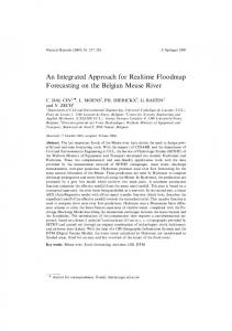
All these stand-alone modules are chained together using open standards as described below. For the real-time data integration component, we have developed a data store extension to the open-source product GeoServer2 1.6. This plug-in enables the direct integration of OGC SOS responses (in O&M [Observations and Measurements] format) into GeoServer and their conversion to OGC-conformal service messages on-the-fly. The main advantage of this approach is that sensor data are made available through a variety of established geo-standardised interfaces (e.g. OGC’s WFS, WMS, GML or KML), as well as custom formats (e.g. SVG, PDF or geoRSS). During the conversion procedure from O&M input to WFS output, certain input parameters (coordinate reference system, unit conversions, data structures etc.) are interpreted. In practice, this means that the O&M XML structure is transformed into well-established standardised data formats as mentioned above. The innovation in comparison to previous data integration approaches is that the conversion of the data structure from SOS responses to various WFS, WMS and WCS output formats is performed on-the-fly. Conventional methods typically use the laborious interim step of storing data in a temporary database, whereas our approach enables data provision of real-time measurements for heterogeneous application domains and requirement profiles. The direct conversion of data structures allows for the easy integration of sensor data into GIS applications and therefore enables fast and ubiquitous visualisation and data analysis. In its current implementation, geographical analysis is performed by ESRI’s ArcGIS software suite since reliable open processing services are not yet available. We created a Live Sensor Extension that allows for the direct integration of standardised sensor data into ArcGIS. The Live View component enables ad-hoc GIS processing and visualisation in a navigable map using ESRI’s Dynamic Display technology. Fig. 2 shows an interpolated temperature surface in ArcScene using the Inverse Distance Weighting (IDW) algorithm. In addition to ArcGIS, we have also used a number of open/free clients such as Open Layers, uDig, Google Maps, Google Earth or Microsoft Virtual Earth to visualise sensor information in 2D and 3D.
B. Implementation The implementation of the real-time geo-awareness approach comprises tailor-made sensing devices, a real-time data integration mechanism, a use case specific interpolation model and an automatic server-based analysis component. 1
http://www.opengeospatial.org
Figure 2. 3D Interpolation Using the Inverse Distance Weighting (IDW) Algorithm. 2
http://www.geoserver.org
We also implemented a measurement device designed for pervasive GIS applications using ubiquitous embedded sensing technologies. The sensor pod consists of a COTS embedded device with a GPS module for positioning, and it runs a customised version of Linux with an embedded web server, an SQLite database, and a standardised data retrieval service implementing the OGC Sensor Observation Service (SOS), SensorML and Observations and Measurements (O&M) standards in an application-specific way. Furthermore, we implemented an XMPP (Extensible Messaging and Presence Protocol) based alerting mechanism conformant to the OGC Sensor Alerting Service (SAS) specification, which is currently being enhanced by CEP and ESP functionalities for advanced event detection. [14] The next release of the implementation will enable a wide range of collection and reporting possibilities for integration into existing decision support systems in a variety of application areas, yielding a more complete and accurate real-time view of the city. CEP and ESP integration will allow for management of pre-defined domain violations (e.g. geo-fencing), and for tracing and analysing spatio-temporal patterns. VI.
EFFECTS ON THE URBAN CONTEXT
From a socio-political viewpoint, real-time geoawareness is primarily targeted at the information needs of local and regional governments. It enables them to respond to the environmental and social challenges of the city and to learn more about the impacts of urban policies and practices. Moreover, it also supports professionals, such as urban and transportation planners, in building or refining their models of urban dynamics. This method also partially addresses the ‘digital divide’ between humans and the environment. Indeed, the communication of data collected from pervasive sensor networks may not trigger sufficient motivation for people to change their habits towards a more environmentally sustainable lifestyle. This raises a real challenge: how can we encourage, promote and motivate environmentally sustainable behaviours on the basis of real-time geoawareness information? Recent work [15] shows how realtime information about cities and their patterns of use, visualised in new ways, and made available locally ondemand in ways that people can act upon, may make an important contribution to sustainability. Even if our approach seeks to provide a complete picture, meaning can also emerge from incomplete heterogeneous environmental data patched together by data mining, filtering and visualisation algorithms. The fluctuating quality and partial coverage of the data can impact people’s perception of the environment, by providing a quasi-objective but inaccurate angle of the content, and potentially ‘negatively’ influencing their behaviour. One solution for this problem could be altering the current model whereby civic government would act as sole data-gatherer and decisionmaker by empowering everyday citizens to collectively participate in super-sampling their life, city, and environment. For instance, Participatory Urbanism [16] investigates the empowerment of citizens to collect and share
air quality data measured with sensor-enabled mobile devices, and it also explores a wide range of novel physical sensors attached to mobile devices, empowering everyday non-experts with new ‘super-senses’ and abilities. Ergo [17] is a simple SMS system that allows anyone with a mobile phone to quickly and easily explore, query, and learn about local air quality on-the-go with their mobile phone. With these tools, citizens augment their role, becoming agents of change by uncovering, visualising, and sharing real-time air quality measurements from their own everyday urban life. This people-centric view of measuring, sharing, and discussing our environment might increase agencies’ and decision makers’ understanding of a community's claims, thereby potentially increasing public trust in the information provided by a real-time geo-awareness approach. However, it should be noted that there are also current discussions about the enforcement of mathematical modelling using the calibration of models with only a few sensor nodes and complementing data sources to create a set of spatial indicators. All of the above examples consider the use of sensed data to satisfy public or private requirements of some sort. However, terms like ‘air quality’ are effectively only a surrogate for the health effects of pollutants on people or structures, and there is much disagreement on the public information regulations and whether they are effective. One potential alternative is the direct sensing of structural, or even human, impacts. In other words, people need to be sensitised to their location and their environment, and this information will have to be presented within different contexts, such as public safety, energy consumption or sustainability in order to open new possibilities for exploring the city. In sum, feedback of ‘sensed’ data to the public – either directly or after processing – can potentially change people’s perception of the city itself. For example, weather or pollution prediction on a very local scale in space and time is reasonably feasible. Continuous availability of this information would lead to a change in people’s individual behaviour by giving real-time short-term decision support. The real-time geo-awareness approach can play a significant role in achieving this seminal vision. VII. CONCLUSION Ubiquitous and continuous environmental monitoring is a multi-dimensional challenge, and this is particularly true in the urban context. In this paper we have shown which issues have to be considered for environmental monitoring systems in the city, and have outlined how the real-time geoawareness approach can meet these requirements. It stands for the combination of live measurement data with historic data sources in an open standards based framework using server-side processing mechanisms. Its basic aim is twofold: first, automating GIS analysis processes that currently require a considerable amount of manual input, using new server-based processing tools by providing a wholly standardised workflow; second to replace monolithic measurement systems with an open standards-based infrastructure. Since interoperable open systems are not trivial to implement, this motivation has to be initiated
through legal directives like INSPIRE, GMES, SEIS and GEOSS. To prove the system’s portability, we deployed the same underlying framework in different application areas: environmental monitoring (air temperature variation assessment), public health (air quality and associated health effects) and patient surveillance (monitoring of biometric parameters). The next practical realisation will be an urban ‘quality of life’ monitoring system in order to gain a citywide picture of spatial and temporal variations of environmental parameters (particulate matter, pollen concentrations or CO pollution). Their integration with static GIS data (census, traffic emergence, living vs. working places etc.) will maximise significance for local and regional governments as well as for citizens by applying complex GIS algorithms such as kriging or co-kriging to reveal unseen causal correlations between spatial parameters. Other scheduled implementations comprise radiation monitoring and water quality assessment infrastructures. As all of those systems are operated in close cooperation with local or regional governments and thematic actors, we think that the real-time geo-awareness approach will raise awareness of ubiquitous sensing systems and perhaps trigger profound rethinking process in collaboration and cooperation efforts between different authorities in the city. Concluding, it shall be stated that the trend towards extensive availability of measurement data requires a paradigm shift in the global GIS market and its applications for urban environmental monitoring. This applies especially to open data accessibility and intensified collaboration efforts. To achieve far-reaching adoption, the establishment of ubiquitous sensing infrastructures will require a long process of sensitising individuals to their spatial and social contexts, and to how to connect local environmental questions to well-known urban issues such as public safety, energy efficiency, or social interaction. In effect, creating a meaningful context around densely available sensor data and distributing specific information layers makes the environment more understandable to the city management, to the citizens and to researchers by ‘making the abstract real’, i.e. by revealing hidden connections in real-time.
REFERENCES [1] [2]
[3]
[4]
[5]
[6]
[7]
[8]
[9] [10]
[11]
[12]
[13] [14]
ACKNOWLEDGMENT Our approach requires expertise in a wide variety of research areas such as sensor networks, data integration, GIS data and analysis, visualisation techniques etc. We would like to thank all contributing groups at the Research Studio iSPACE and at MIT for their valuable inputs and contributions in different stages of the project.
[15]
[16]
[17]
Paulsen, H. and Riegger, U. (2006). SensorGIS - Geodaten in Echtzeit. In: GIS-Business 8/2006: pp. 17-19, Cologne. Resch, B., Calabrese, F., Ratti, C. and Biderman, A. (2008) An Approach Towards a Real-time Data Exchange Platform System Architecture. Sixth Annual IEEE International Conference on Pervasive Computing and Communications, Hong Kong, 17-21 March 2008. Kansal, A., Nath, S., Liu, J. and Zhao, F. (2007) SenseWeb: An Infrastructure for Shared Sensing. IEEE Multimedia. Vol. 14, No. 4, pp. 8-13, October-December 2007. Murty, R., Mainland, G., Rose, I., Chowdhury, A., Gosain, A., Bers, J. and Welsh, M. (2008) CitySense: A Vision for an Urban-Scale Wireless Networking Testbed. In Proceedings of the 2008 IEEE International Conference on Technologies for Homeland Security, Waltham, MA, May 2008. National Oceanic and Atmospheric Administration (2008) nowCOAST: GIS Mapping Portal to Real-Time Environmental Observations and NOAA Forecasts. http://nowcoast.noaa.gov, 15 June 2008. Sarjakoski, T. et al. (2004) Geospatial Info-mobility Service by Realtime Data-integration and Generalisation. http://gimodig.fgi.fi, 22 May 2008. Rittman, M. (2008) An Introduction to Real-Time Data Integration. http://www.oracle.com/technology/pub/articles/rittman-odi.html, 14 June 2008. Sybase Inc. (2008) Real-Time Events Data Integration Software. http://www.sybase.com/products/dataintegration/realtimeevents, 16 June 2008. Rahm, E., Thor, A. and Aumueller D. (2007) Dynamic Fusion of Web Data. XSym 2007, Vienna, Austria, p.14-16. Riva, O. and Borcea, C. (2007) The Urbanet Revolution: Sensor Power to the People!. IEEE Pervasive Computing, vol. 6, no. 2, pp. 41-49, Apr-Jun, 2007. Resch, B., Schmidt, D. and Blaschke, T. (2007) Enabling Geographic Situational Awareness in Emergency Management. Proceedings of the 2nd Geospatial Integration for Public Safety Conference, April 15-17, 2007, New Orleans, Louisiana, US. Botts, M., Robin, A., Davidson, J. and Simonis, I. (eds.) (2006) OpenGIS Sensor Web Enablement Architecture. OpenGIS Discussion Paper, version 1.0, OGC 06-021r1, 4 March 2006. Schut, P. (ed.) (2007) Web Processing Service. OpenGIS Standard, version 1.0.0, OGC 05-007r7, 8 June 2007. Mittlboeck, M. and Resch, B. (in press) Federal Pervasive Sensor Networks Serving Geographic Information Services. In Proceedings of the 5th International Symposium on LBS & TeleCartography, November 26-28, 2008, Salzburg, Austria Calabrese, F., Kloeckl, K., and Ratti, C. (2008, in press). Handbook of Research on Urban Informatics: The Practice and Promise of the Real-Time City, chapter WikiCity: Real-time Location-sensitive Tools for the City. Hershey. Paulos, E., Honicky, R., and Hooker, B. (2008, in press). Handbook of Research on Urban Informatics: The Practice and Promise of the Real-Time City, chapter Citizen Science: Enabling Participatory Urbanism. Hershey. Paulos, E. (2008) Urban Atmospheres - Proactive Archeology of Our Urban Landscapes and Emerging Technology. Online at http://www.urban-atmospheres.net. (June 18, 2008)