Referential scope and visual clutter in navigation tasks Hans Westerbeek (
[email protected]) Alfons Maes (
[email protected]) Tilburg centre for Creative Computing, Tilburg University Warandelaan 2, 5037 AB, Tilburg, The Netherlands Abstract In a production task, we investigated the effect of visual clutter in route maps on the type of referential expressions used in route descriptions, and on the descriptive efficiency and accuracy of these descriptions. We show that cluttered maps tend to diminish the use of less robust, narrow scope junction expressions (e.g. the next junction), and promote the use of more robust, broad scope landmark expressions (e.g. the post office). Moreover, visual clutter results in the use of more redundant information elements, words, propositions, and incorrect landmarks. Keywords: referential scope; visual detail, visual clutter; route descriptions, route maps.
Introduction Navigation is a core component of cognition and daily life action. People can use route descriptions (RDs) to solve part of their navigation problems. RDs show a large variation depending on prior knowledge (e.g., Lovelace, Hegarty, & Montello, 1999), visuospatial abilities (e.g., Denis, Pazzaglia, Cornoldi, & Bertolo, 1999) and spatial perspectives of users (e.g., Brunyé & Taylor, 2008; Lee & Tversky, 2005; Mellet, et al., 2000; Taylor & Tversky, 1992). Also, RDs vary with the navigation task: route following is different from wayfinding (Hartley, Maguire, Spiers, & Burgess, 2003); actual navigation is different from learning routes for later use (Thorndyke & Hayes-Roth, 1982). The core of RDs consists of the description of actions to be taken (e.g., turn left) and the identification of the location of these actions (e.g., at the barber). Different strategies can be used to successfully identify relevant locations in RDs. In this paper, two of these referential options will be studied in relation to visual characteristics of the route environment.
Reference maintenance and selection in RDs RDs are referentially atypical in that they hardly show chains of different types of referring expressions used to establish and maintain the same referent over larger stretches of discourse. The protagonist in RDs is the navigator, who is easily maintained as the (implied) subject of route instruction imperative verbs (e.g., [You] turn left). Most of the discourse referents in RDs appear and disappear as the route develops: path and landmark referents are mentioned in the relevant route segment, and need not be maintained in the remaining discourse. This makes RDs hardly relevant for pronoun resolution algorithms or accessibility analyses of subsequent references. Selecting relevant referents in RDs is less trivial, however. In describing each route segment, people have to
decide whether and what referents are helpful or necessary to identify relevant actions and locations, in order to ensure optimal navigation or remembering a route on a map. When asked to instruct someone how to go to the bank office (i.e., the depicted route in Figure 1), one can use “Two times left” as an adequate and unambiguous answer. There is a fair chance, however, that those instructions are enriched with different types of referential expressions: “Walk one block straight up to the next junction. There, you see a barber on your left. Turn left. Walk one block straight up to the next junction. There, you see a pub in front of you. Turn left again and walk one block straight up again to the next junction. The bank office is on your right.” Different conditions make the selection of referents in maps and RDs challenging. The set of relevant referents changes over time as the route unfolds; the variety of environments, maps and routes makes the availability of salient referents unpredictable. Moreover, referents may not only be visible, but also hidden in users’ knowledge (e.g., Go left where we met yesterday), as common ground and prior knowledge are important sources of route relevant referents. Also, their conceptual range is varied (points, paths, regions), and the sum of all this is a holistic view of a naturalistic scene, rather than a clear set of target and distractor entities (Rosenholtz, Li, & Nakano, 2007). The unpredictability, definition and variation of relevant entities in navigation environments complicates the development of algorithms for the automatic production of RDs in different navigation situations (Dale, Geldof, & Prost, 2004; Koller, Striegnitz, Byron, Cassell, Dale, Moore & Oberlander, 2010; Paraboni, Van Deemter, & Masthoff, 2007). Despite this variability, recent navigation studies show that one referential strategy is stable in producing RDs: the tendency to add referents at choice or decision points, i.e., locations in a real environment or on a map which afford pathway options, and thus require a decision on the part of the navigator (Allen, 2000; Daniel & Denis, 2004; Denis, et al., 1999). According to Allen (2000), adding references at decision points “is one way to achieve referential determinacy by making it clear exactly what environmental features will be encountered by the traveller at choice points and how he or she should respond.” (p. 335). Daniel & Denis (2004) asked respondents to describe well known routes as concise as possible, and concluded that landmarks at decision points underwent less reduction than other landmarks. This strategy aligns more or less with the preference for landmark descriptions over street descriptions (Tom & Denis, 2004), as landmarks mostly represent points on a map, and therefore, they may be better suited to mark decision points in routes.
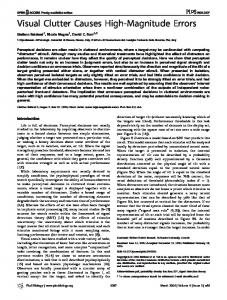
For current purposes we define decision points (DPs) as route intersections where the navigator either has to continue (i.e., go left, right, straight on) or to stop. For example, the route depicted in Figure 1 has three DPs. The starting point (right) is given, the route turns left (DP1), left again (DP2) and ends one block ahead, at the destination point (DP3).
Figure 1: cluttered (top) and schematic (bottom) route map. The route is depicted with red dots, with a green starting point pointing in the initial direction (right) and a blue destination point (left).
Referential scope of landmarks and junctions Decision points in routes can be uniquely identified by route independent landmarks (e.g., Go left at the restaurant) or by route dependent descriptions (e.g., Go left at the next junction). In the navigation literature the term landmark refers to salient objects along the route, which are referred to either by using a proper name (Eiffel Tower), a definite description (the church with three towers) or an indefinite description (a large restaurant). Route dependent references use definite or indefinite descriptions referring to parts of the route itself (the next intersection, a T-junction). For the sake of clarity, we will refer to these two reference types as landmarks vs. junctions respectively. Landmarks and junctions can be seen as part of what Denis et al. (1999: 150) call our “shared metacognitive knowledge” of routes.
In analytical studies of RDs, junctions are mostly implied as a subclass of landmarks (e.g. Klippel & Winter, 2005), but the two entities have never been distinguished systematically. When someone chooses to describe DP1 in Figure 1 as “Go left at the barber” or as “Go left at the first junction”, what exactly makes this choice referentially different? The two definite description result in a unique and unambiguous identification of DP1. The main difference is the visual and discourse scope within which their denotation holds. The denotation of the first junction only applies to the visual scope in between the starting point and DP1, and in the corresponding RD segment. The scope validity of the barber is wider and applies to the whole map, and to the whole RD. The first junction only makes sense in one spatial perspective taken on the map, i.e., the route (as opposed to the survey) perspective, whereas the barber is not dependent on spatial perspective. The wider scope makes landmarks more referentially robust than junctions. However, junctions (more than landmarks) are directly related to the navigation task, as they are part of the route itself, and they are always there, while some decision points may lack obvious landmarks. This makes junctions more readily accessible in RDs. These referential differences align with conceptual differences. Landmarks are more ‘what’ entities than ‘where’ entities, but junctions are the other way around (Landau & Jackendoff, 1993). Landmarks tend to activate conceptual knowledge which exceeds the realm of navigation. This makes them useful as anchor for memorizing routes. Junctions, on the other hand, do hardly evoke more than spatial and locational features as their core meaning. Finally, junctions are part of a larger whole (the map), whereas landmarks have a more independent conceptual status, which makes them more typical first order entities than junctions (Lyons, 1977). These differences create an interesting strategic choice in RDs: either navigators can trust on narrow scope junction references, which are easily accessible and easy to resolve in the route perspective, while they are also easily losing their robustness, for example in the case of disorientation. Navigators can also opt for broader scope landmarks, with a higher production and resolution cost (because of the larger search space with more distractors), but also with a higher robustness gain. The aim of our production study is to construct a task situation in which landmark and junction entities are equally available, and to explore whether people exploit them differently when the referential task is varied. In the next section, we will argue that varying the visual complexity of maps may elicit different preferences for the use of landmarks and junctions and their respective referential strategies.
Detail in maps and RDs Maps and RDs can both be different in the level of detail and the types of features included. Detail in RDs affects the quality of navigation tasks. For example, Tom and Tversky (2011) systematically varied the vividness of street and landmark descriptions in a map learning task, and found that
vividly described elements were remembered better. An explanation of this effect is suggested by Holmes & Wolff (2011). They presented respondents with sentences containing adjectives or spatial prepositions, followed by visual objects, identical in information load, but different in visual detail (line drawings vs. photographs), and concluded that adjectives tend to result in more realistic mental simulation than prepositions. In turn, this realistic mental simulation may help people to remember. Visual features of maps, like color or detail, may affect route learning as well. Mixed results can be found in the literature. For example, Devlin & Bernstein (1997) did not find a difference in search efficiency between detailed and less detailed maps, whereas Abu-Obeid (1998) reported more errors in map drawing tasks based on scenographic (as opposed to abstract) maps. Support for the idea that schematic maps are more effective than detailed comes from recent experiments by Holmes & Wolff (2010), which show that schematic depictions facilitate the processing of implied motion better than photorealistic depictions. Visual detail also affects language production. For example, Coco & Keller (2009) concluded that the more detailed or ‘cluttered’ the visual environment was, the longer it took respondents to start typing their response. Moreover, realistic scenes tended to result in the production of more complex constructions. More recently, they also found that cluttered environments resulted in more complex eye tracking patterns (Coco & Keller, 2010).
Present Study This paper investigates the effect of visual detail on the selection of referents in route descriptions. We define map detail as visual clutter, a measure of visual complexity composed of three physical variables in scenes (i.e., feature congestion, sub-band entropy and edge density, see Henderson, Chanceaux, & Smith, 2009; Rosenholtz, Li, Nakano, 2007) and used two map types to create different levels of clutter: satellite photographs (cluttered) and map views (schematic). Figure 1 illustrates the two types. We expect the referential choice between landmarks and junctions to be mediated by the level of visual clutter of maps. In particular, we expect junctions to be used more in RDs based on schematic maps and landmarks more in RDs based on realistic, cluttered maps. Narrow scope junctions are an easy and safe choice when maps are visually simple (schematic), but they are less reliable as the scene becomes more cluttered and complex. Conversely, broad scope landmarks need not be used when maps are visually simple, but their robustness becomes more useful as visual complexity increases. To test this expectation, we asked respondents to carry out simple route learning and production tasks. They were presented with either cluttered or schematic maps, and were asked to orally describe an adequate route description. The task stimulated respondents to produce RDs using a limited number of actions and referents. Apart from looking at the choice between landmarks and junctions, we explored other differences in RDs that may relate to visual clutter as well. In line with Coco and Keller’s (2009) finding that cluttered scenes tend to result in
longer and complex sentences, we looked at the descriptive efficiency of RDs in the two conditions. Note that cluttered maps did not provide our respondents with more task relevant information than schematic maps. As a result, different descriptive features were not expected, but the presence of irrelevant visual detail in the cluttered version may result in more verbal production (number of words or propositions), or in irrelevant information elements. Finally, we also compared the accuracy of RDs in the two conditions. Following performance differences in other studies (e.g. longer response latencies in Coco and Keller, 2009) we may expect more route errors in cluttered map descriptions.
Method Participants Forty-five Tilburg University undergraduate students, 38 females and 7 males, participated in the experiment for course credits. Their mean age was 22 years, ranging from 18 to 35. All participants were unaware of the goal of the experiment, and had normal or corrected-to-normal vision. They were randomly assigned to either the cluttered or the schematic map condition. Stimuli Twenty-four different routes were set out on the same map, a section of a map of Upper East Side Manhattan (New York City, NY, USA). Eight routes were short, the other sixteen long. For current purposes, we only used the short routes. The short routes consisted of three route segments each; each segment consisted of a path leading to a decision point. Each DP coincided with a four way junction and a landmark. The starting point and initial direction were given. Four short routes contained two left-right DPs and the destination DP (as in Figure 1), the other four contained one left-right DP, one straight decision point, and the destination DP. The depicted routes aimed at offering respondents a limited set of elements per route segment. Applied to DP1 in Figure 1, the following elements were expected: a landmark referent (the barber), a junction element (the next junction), the action to be carried out at DP (take left), and the action leading up to the DP (continue straight). Landmark and junction referents were considered to be equally available and competing. The action at DP was considered the descriptive minimum of each segment, the action in between DPs was considered less crucial to the task. The relative importance of actions at in between DPs was confirmed in a small scale evaluation study, in which 20 respondents rated the relevance of these elements on a 10-point scale (MatDPactions=9.72; MbetweenDP-actions=6.06; t(19)=7.30, p