Plant Soil (2011) 340:89–102 DOI 10.1007/s11104-010-0460-9
REGULAR ARTICLE
Response of soil moisture and temperature to grazing intensity in a Leymus chinensis steppe, Inner Mongolia Ying Zhao & Stephan Peth & Agnieszka Reszkowska & Lei Gan & Julia Krümmelbein & Xinhua Peng & Rainer Horn
Received: 30 December 2009 / Accepted: 1 June 2010 / Published online: 22 June 2010 # Springer Science+Business Media B.V. 2010
J. Krümmelbein Chair of Soil Protection and Recultivation, Brandenburg University of Technology Cottbus, Konrad-Wachsmann-Allee 6, 03046 Cottbus, Germany
moderately grazed only in winter time (WG), and heavily grazed (HG). At each plot, we recorded the soil moisture and temperature over a 6-year period that spanned between June 2004 and September 2009 and experienced a large range in precipitation (162 to 362 mm). Based on these monitoring data, we divided a year into four hydric periods: (1) growing period (late April to August); (2) transitional period from summer to winter (September– October); (3) winter time (November–first March); and (4) transitional period from winter to summer (March–April). In general, soil moisture in grazed sites was lower than in the ungrazed site, particularly for the 30–50 cm soil layer. Seasonal fluctuation of the soil moisture, due to variable precipitation and atmospheric demands, was most significant in the topsoil (0–10 cm) and was less pronounced in deeper soil. Regardless of hydric seasons, soil moisture was significantly influenced by grazing intensity, whereas soil temperature was slightly influenced. With increasing grazing intensity, soil water storage decreased remarkably. Consequently, grazing reduced plant available water and therefore grassland productivity, which are linked to a great extent with the trampling-induced soil structure change and soil moisture regime.
X. Peng State Key Laboratory of Soil and Sustainable Agriculture, Institute of Soil Science, CAS, Nanjing, China
Keywords Long-term monitoring . Grazing intensity . Soil moisture . Soil temperature . Plant available water . Semiarid steppe
Abstract Long-term monitoring of soil properties reveals site-specific ecosystem shifts in soil processes due to land use and climate changes. This paper aims to study the effects of physical landscape changes associated with grazing on soil thermal and moisture regime at the plot scale in a semiarid Leymus chinensis steppe of Inner Mongolia, China. The investigated sites were subjected to three grazing intensities: ungrazed since 1979 (UG79),
Responsible Editor: Ingrid Koegel-Knabner. Y. Zhao (*) College of Resource and Environment Science, Northwest Agriculture and Forestry University, Yangling 712100 Shaanxi, People’s Republic of China e-mail:
[email protected] Y. Zhao : S. Peth : A. Reszkowska : L. Gan : R. Horn Institute of Plant Nutrition and Soil Science, Christian-Albrechts-University zu Kiel, Olshausenstr. 40, 24118 Kiel, Germany
90
Introduction Livestock grazing is recognized as one of the main causes of soil and vegetation degradation in grassland areas. Given the vital importance for the production of livestock and the potential implications of climate change, it is crucial to have a thorough understanding of ecosystem responses to grazing intensity (Lauenroth and Bradford 2006). As much grassland is located in arid and cold areas, soil water and temperature regimes are key variables determining ecosystem development in such regions. It is therefore most necessary to investigate the response of thermal and hydrological processes to land use/climate change in order to assess their consequences on plant production and the environment. However, a comprehensive knowledge of these processes has not yet been achieved (Sugita et al. 2007). In particular, there have been no long-term studies of annual cycles and seasonal variations of soil heat and water. Soil heat and water regimes can be modified by different land uses due to differences in vegetation cover and soil conditions. Grazing associated with animal activity alters soil thermal, hydraulic and mechanical properties. Soil mechanical disturbances, interlinked with hydrological changes, often have detrimental effects on soil properties. Warren et al. (1986) reported that animal trampling caused soil deformation by exerting high ground contact pressures under their hooves. Particularly in the topsoil, soil deformation is characterized by altered pore volume, size distribution and connectivity, with major impacts on water and air conductivity (Greenwood et al. 1997; Zhao et al. 2010), and soil water retention characteristics (Martinez and Zinck 2004; Kutilek et al. 2006). Animal trampling is a short-time dynamic process, meaning that the soil undergoes repeated sequences of loading, unloading and reloading events (Peth and Horn 2006). This dynamic stress change under repeated loading causes more intense inter-particle shear deformation compared to the compaction under static loading. Furthermore, in the damaged area, soil will be more vulnerable to compaction, erosion by water and wind, and nutrient depletion by leaching and poorer microbial habitat (Zhang et al. 2010). As a result, ecosystem productivity is highly determined by both nutrient pools and soil physical parameters, such as soil structure, soil thermal and moisture regimes.
Plant Soil (2011) 340:89–102
In arid or semiarid environments, the key thermal and hydrological processes are their particular aridity and seasonality, in which high and relatively constant atmospheric demands exceed a low and highly variable precipitation regime. These factors determine the temporal dominance of soil drought. The warm season coinciding with a wet period allows the relatively high ecosystem productivity. Therefore, the temporal distribution of the wet periods, their duration, and the effective root zone for water availability might be critical explanatory information for both the structure of ecosystems and the rates of processes (Sala et al. 1992; Lauenroth and Bradford 2006). Especially, the distribution of precipitation (not the total annual precipitation) plays a key role in determining the annual evapotranspiration and plant productivity in this region (Burba and Verma 2005). For instance, summer rains mainly recharge the topsoil except for macropore flow, while deeper soil layers may only be recharged during snowmelt. Consequently, water from winter precipitation could be better used by deep rooted plants while shallow rooted plants are restricted to summer rains. Spatial and temporal monitoring of soil thermal and moisture regimes are basic and essential tools for understanding additional emerging processes that degrade pastures. In arid and semiarid regions, vegetation cover could be strongly controlled by the water availability, especially considering the plant response to normal seasonality, to between-year irregularities and to extreme drought events (Casas and Ninot 2007). The contrast between long-term studies, which find a relationship between water and vegetation responses, and many short-term studies, which do not, suggests that water effects accumulate over time and may not result from single-season variation in water availability (Köchy and Wilson 2004). In Inner Mongolia grassland, the assessment of grazing impacts on soil water have been limited to a single growing season, shallow soil depths, and shortterm grazing treatments (Li et al. 2006). Identifying seasonal and annual variation in this area requires well documented analyses of soil water and temperature regimes, based on long-term experimental studies. During the past 6 years (2004–2009), the MAGIM project (Matter fluxes in grasslands of Inner Mongolia as influenced by stocking rate) was carried out in Inner Mongolia grassland to understand how sheep
Plant Soil (2011) 340:89–102
grazing affects water, carbon and nitrogen fluxes at various spatial and temporal scales. Under the framework of this project, we focused on monitoring and analyzing soil water and temperature in different grazing plots. Our objectives were: (1) to investigate the grazing effects on soil physical, hydraulic and mechanical properties; (2) to characterize and compare the temporal and vertical distribution of soil water and temperature regime in different grazing plots; and (3) to evaluate the relative importance of plant available water and its temporal distribution for ecosystem productivity. In this paper we present results from nine monitoring sites where soil moisture and temperature were measured for a period of 6 years under three grazing intensities. Studies of grazing gradients that reflect a realistic range of long-term grazing impacts will provide an ideal opportunity to test the nature of potential threshold responses in grassland ecosystems, especially in the colder regions of the globe.
Materials and methods Study site The long-term experimental site is located at the Inner Mongolia Grassland Ecosystem Research Station (IMGERS; 43°37′50″N, 116°42′18″E), Chinese Academy of Sciences. The region is defined as continental semiarid grasslands of the Central Asian steppe ecosystem, with a dry and cold middle latitude climate (Kawamura et al. 2005). Mean annual temperature at IMGERS is 0.7°C and mean annual precipitation is around 350 mm, most of which happed in summer from June to August. Vegetation is characterized as a typical Leymus chinensis steppe with a relatively short vegetation period from May to September (50 μm) at the undisturbed control site. In the topsoil, calculated fractions of different pore size classes showed that the reduction in total pore volume at the two grazed sites was accompanied by a decrease of macropores by 3–10% while the amount of mesopores (0.2–50 μm) increased by 3–6%. Due to a higher trampling intensity in HG site, the macropores fraction of this site with the coarse-textured was much smaller than that of the fine-textured WG site. This change in pore size distribution also showed a noticeable effect on the hydraulic conductivity function. That is, consistent with the soil water characteristics, the predicted unsaturated conductivity K(h) curves showed similar trends between treatments. The WG site showed the lowest K(h) values for a wide range of suctions in the topsoil and also in the deeper soil below −10 hPa. Compared to the UG79 site, HG site had a lower K(h) values near saturated and higher K(h) values for matric potentials below −10 hPa. Four hydric periods In all three plots, soil moisture and temperature showed roughly similar seasonal dynamics with the regular yearly cycles throughout the investigated 6 years that spanned between June 2004 and September 2009 and experienced a large range in precipitation between 162 and 362 mm (Figs. 2 and 3). The years 2004 and 2009 were more humid than 2005, 2006, 2007 and 2008. In general, we are able to segregate four hydric periods within each hydrological year: &
(i) Growing period (late April–August), when the soil water content remained relatively high (normally >10%), and the soil temperature is normally higher than 10°C. This phase is the key period for
94
Plant Soil (2011) 340:89–102
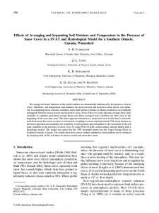
Fig. 1 Soil water retention curves (left) and hydraulic conductivity/matric potential curves (right) at 5 (top), 20 (middle) and 40 cm (bottom) soil depths in UG79 (black), WG (red) and HG (blue). Black box (UG79), red circle (WG) and blue triangle (HG) showed measured value with standard deviation, which was fitted by van Genuchten parameters (solid and dot line). UG79: ungrazed since 1979, WG: moderately grazed only in winter time, and HG: heavily grazed
&
&
&
grass growth in the studied area, where high available water coincides with high temperature. (ii) Transitional period from summer to winter (September–October), when temperature and potential evapotranspiration decrease, and plants stop growth. (iii) Winter time (November–first March), when the temperature is below 0°C, and soil water is mostly frozen, thus the liquid water content is less than 5%, and the matric potential is therefore extremely negative. The low precipitation and strong wind usually result in a shallow, but often unevenly distributed snow-cover. (iv) Transitional period from winter to summer (March–April), when temperature and potential evapotranspiration increase, and may result in an intense surface runoff from the frozen soil layer. Ice and snow melting recharges the water storage and initiates plant growth.
Seasonal and interannual variability of soil moisture and temperature affected by grazing intensity During the whole monitoring period, soil water content (liquid) showed strong seasonal variations fluctuated with precipitation and temperature, ranging from 0.02 to 0.32 cm3 cm−3 for UG79, 0.01 to 0.31 cm3 cm−3 for WG, and 0.01 to 0.26 cm3 cm−3 for HG (Fig. 2a). The seasonal precipitation in 2006 provided a good example for analysing the dynamics of soil water in a single year (Fig. 2b). Low standard deviation indicated a small spatial variability. Thus, soil water varied only slightly between different monitoring sites within each plot with relatively flat terrains. A major increase in soil water due to higher repeated precipitation events occurred primarily in June and July. However, these water dynamics were more pronounced in the topsoil (0–10 cm) compared to the subsoil, indicating a small water infiltration into
Plant Soil (2011) 340:89–102
95
Fig. 2 a, Daily changes of soil water content (from 2004 to 2009) in the three sites at 5, 20, and 40 cm soil depths; b, Annual distribution of soil water content in a typical hydrological year (from September 2005 to August 2006). UG79: ungrazed since 1979, WG: moderately grazed only in winter time, and HG: heavily grazed
deep soil. These remarkable water dynamics only at shallow soil depths could be the result of (1) a distribution of relatively small rainfall events, (2) a rainy season in synchrony with the warm season which constrains the possibilities of recharge of the soil profile, and (3) potential evapotranspiration rates much greater than precipitation. Although temporal patterns of water content were not affected by grazing, the water redistribution in the profile was clearly affected (Fig. 2). In general, the soil water content was always lowest in HG for all depths throughout the year. In the deeper soil layer (30–50 cm), soil moisture in UG79 remained relatively constant and significantly (p