Sep 30, 2004 - Department of Environmental Sciences, University of Virginia, ... southern cratered highlands from the northern lowland plains by 1–3 km of ...
JOURNAL OF GEOPHYSICAL RESEARCH, VOL. 109, E09011, doi:10.1029/2004JE002248, 2004
Sedimentary resurfacing and fretted terrain development along the crustal dichotomy boundary, Aeolis Mensae, Mars Rossman P. Irwin III1 and Thomas R. Watters Center for Earth and Planetary Studies, National Air and Space Museum, Smithsonian Institution, Washington, D. C., USA
Alan D. Howard Department of Environmental Sciences, University of Virginia, Charlottesville, Virginia, USA
James R. Zimbelman Center for Earth and Planetary Studies, National Air and Space Museum, Smithsonian Institution, Washington, D. C., USA Received 6 February 2004; accepted 1 June 2004; published 30 September 2004.
[1] The evolution of the Martian crustal dichotomy boundary, which separates the
southern cratered highlands from the northern lowland plains by 1–3 km of elevation, remains among the fundamental outstanding issues in Mars research. For a study area at Aeolis Mensae we show that fretted terrain formed exclusively in a >2 km thick, late Noachian (�3.7 Ga) sedimentary deposit that overlies the base of an older, cratered dichotomy boundary slope. In this equatorial study area, fretted terrain does not exhibit the debris aprons or lineated valley fills that are attributed to ground ice in otherwise similar, midlatitude fretted terrain in Arabia Terra. The massive deposit of fine sand or loess was probably transported from the north by wind and trapped against the precursor dichotomy slope, producing a similar initial form to the younger Medusae Fossae layered materials that occur east of Aeolis Mensae. Contemporary with the latest Noachian to early Hesperian decline in fluvial erosion, the fretting process likely initiated as the massive layer’s indurated surface was compromised by fracture, cratering, or collapse into possible voids. In these depressions, grain impact or contact with water disaggregated the fine sedimentary materials, which were then largely deflated by wind. The fretting process largely ended when liquid water was no longer widely available for weathering during the early Hesperian period, although some degradation of the region by aeolian and slope INDEX TERMS: 5415 Planetology: Solid Surface Planets: processes has continued to the present. Erosion and weathering; 5470 Planetology: Solid Surface Planets: Surface materials and properties; 6207 Planetology: Solar System Objects: Comparative planetology; 6225 Planetology: Solar System Objects: Mars; KEYWORDS: Aeolis Mensae, fretted terrain, sedimentary deposits Citation: Irwin, R. P., III, T. R. Watters, A. D. Howard, and J. R. Zimbelman (2004), Sedimentary resurfacing and fretted terrain development along the crustal dichotomy boundary, Aeolis Mensae, Mars, J. Geophys. Res., 109, E09011, doi:10.1029/2004JE002248.
1. Introduction [2] The Martian crustal dichotomy is a pronounced topographic break of 1– 3 km in elevation, separating ancient cratered highlands located predominantly in the Southern Hemisphere from smooth, younger lowland plains to the north (e.g., Aeolis Mensae study area in Figure 1a). The origin of the dichotomy remains among the major outstanding questions in Mars research. Theories for its origin 1 Also at Department of Environmental Sciences, University of Virginia, Charlottesville, Virginia, USA.
Copyright 2004 by the American Geophysical Union. 0148-0227/04/2004JE002248$09.00
include endogenic and exogenic mechanisms, with the former category generally invoking degree 1 convective overturn of the mantle and crustal thinning to form the lowlands [Lingenfelter and Schubert, 1973; Wise et al., 1979; Davies and Arvidson, 1981; Janle, 1983; McGill and Dimitriou, 1990; Zhong and Zuber, 2001]. Sleep [1994] proposed a plate tectonic scenario to explain the dichotomy. Exogenic mechanisms involve one giant impact [Wilhelms and Squyres, 1984] or multiple [Frey and Schultz, 1988, 1990] giant impacts into the Northern Hemisphere, resulting in a net redistribution of material into the southern highlands. McGill and Squyres [1991] and Zuber [2001] reviewed theories for the origin of the crustal dichotomy. More recently, Watters [2003a, 2003b] suggested that the dichotomy boundary (a transitional zone between cratered
E09011
1 of 20
E09011
IRWIN ET AL.: FRETTED TERRAIN IN AEOLIS MENSAE, MARS
Figure 1
2 of 20
E09011
E09011
IRWIN ET AL.: FRETTED TERRAIN IN AEOLIS MENSAE, MARS
highlands and lowland plains, rather than a linear feature) underwent flexure induced by loading of the northern lowlands. Counts of buried lowland impact craters constrain the age of the lowland crust (and perhaps the dichotomy itself) to the early Noachian period [Frey et al., 2002], to which Hartmann and Neukum [2001] apply an age of >3.95 Ga. [3] Significant erosion and burial of the dichotomy boundary occurred from its time of formation into the early Hesperian period [Neukum and Hiller, 1981; Maxwell and McGill, 1988; McGill, 2000] (until 3.6 Ga [Hartmann and Neukum, 2001]). These modifications are contemporary with or postdate the declining cratering rates [Hartmann and Neukum, 2001], waning fluvial activity [Craddock and Maxwell, 1990], and reverse faulting along the dichotomy boundary [Watters and Robinson, 1999]. Erosion of the boundary included late Noachian to early Hesperian development of knobby and fretted terrains from high-standing surfaces (Figures 2 and 3a – 3c). Lacking an established terrestrial analogue, the fretting process has remained poorly understood to the present [Carr, 2001]. In fretted areas, broad, flat-floored valleys isolate large mesas and knobs with up to 2 km of relief (Figures 1– 3), or the fretted valleys occur as deep reentrants into high-standing terrain with limited tributary development (Figure 2) [Sharp, 1973]. Most studies of the dichotomy boundary morphology have focused on the midlatitude fretted terrain on the northern margin of Arabia Terra. In this region, late Noachian and early Hesperian structural [McGill and Dimitriou, 1990] and/or fluvial processes [Carr, 2001] may have initially isolated the mesas, as indicated by an irregular grid pattern or linear trend to most valleys, along with some sinuous valleys that deeply dissect the adjacent highlands (Figure 2b). Ice-facilitated mass wasting is interpreted to be responsible for Amazonian degradation of this region [Squyres, 1978; Lucchitta, 1984; Mangold and Allemand, 2001; Mangold, 2003], forming the characteristic lineated valley fill and debris aprons around mesas and valley walls (Figures 3a and 3b) after the fretted valleys were incised [Squyres, 1978]. [4] Knobby terrain consists of smaller isolated hills with flat or rounded summits, which are often located north (downslope) of the fretted terrains along the dichotomy boundary. The knobs decrease in size and density with distance from the boundary (Figure 2b), suggesting that this knobby terrain represents a late stage in the degradation of fretted terrain mesas [Sharp, 1973]. Volcanic flows have buried the dichotomy boundary in the Tharsis region [Scott and Tanaka, 1986]. From Tharsis west to Aeolis Mensae, sedimentary materials of the Medusae Fossae Formation bury parts of the dichotomy boundary (Figure 3d) [Scott and Tanaka, 1986; Greeley and Guest, 1987]. Medusae
E09011
Fossae is thought to be a relatively young, friable, aeolian sedimentary deposit of sand or volcanic ash [Bradley et al., 2002; Hynek et al., 2003]. [5] This paper focuses on the history of modifications to one section of the dichotomy boundary, including the development of fretted and knobby terrains in Aeolis Mensae (10�N – 10�S, 120� – 150�E, Figure 1). By evaluating the geomorphic processes that have affected the dichotomy boundary throughout its history, we isolate ancient features of the dichotomy and distinguish these from younger landforms that developed under different circumstances. The purpose of this paper is not to settle the issue of the dichotomy’s origin, which would require a detailed examination of large-scale, ancient endogenic and exogenic mechanisms during a time that is poorly represented by the geologic record. We discuss evidence for several distinct geologic material units in the region, noting that fretted terrain is confined to a likely sedimentary deposit with distinct morphologic and thermal properties. We then discuss geomorphic processes that have affected these terrain units relative to the time-stratigraphic scale of Tanaka [1986]. This analysis relies on a critical rationalist approach [Bartley, 1964], whereby Earth-based processform relationships are used to evaluate alternate hypotheses for the origin of Martian landforms.
2. Features of the Study Area [6] Broadly similar fretted terrains occur along the dichotomy boundary in Arabia Terra (�25� – 50�N, 10�– 80�E) and at the present study area, Aeolis Mensae (10�N –10�S, 120�– 150�E) (Figure 2), but the two regions exhibit some morphologic dissimilarities (Figure 3). Isolated mesas and knobs occur in both areas, transitioning to smaller knobs with rounded summits at greater distances from the dichotomy scarp. Both areas also contain elongated reentrants into high-standing surfaces, which originate at chains of closed depressions or are connected to sinuous, branching (likely fluvial) highland valleys. However, fretted terrains in the equatorial region do not exhibit lineated valley fill and debris aprons, which are distinctive in the higher latitudes (>30�) north of Arabia Terra (Figures 3a and 3b). The low crater density on debris aprons [Mangold, 2000, 2003], the irregular floor topography of sinuous fretted valleys due to apron development [Lanz et al., 2000; Carr, 2001], and the likely development of lineated fill from cross-valley (rather than down-valley) mass wasting [Carr, 2001] support development of debris aprons after the primary terrain fretting process had ceased [Squyres, 1978]. The Aeolis Mensae region valleys are also more sharply defined, with less rounding of valley wall crests
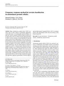
Figure 1. Topography of the study area from the 128 pixel/degree Mars Observer Laser Altimeter (MOLA) topographic grid. (a) Study area showing tracks of topographic profiles in areas c, d, and e. (b) Enlargement of fretted and knobby terrains along the boundary, showing locations of images in other figures. Note change in orientation relative to Figure 1a. Gale Crater is the location of area 5a. The western side of the study area is dominated by several closed depressions (large white arrow) that formed in an initial northward slope; smooth plains embay the center of the study area, and the eastern side contains the fretted plateau. The elevated ridge to the northeast of the fretted plateau is the Medusae Fossae Formation. (c) Cross section of the irregular closed depression in the knobby terrain. (d) Cross section of the most deeply eroded part of the boundary in the study area, where smooth plains embay remnant knobs of the fretted plateau. (e) Cross section of the fretted plateau at �1000 m, with an eroded ridge of Medusae Fossae Formation at �2000 m. 3 of 20
E09011
IRWIN ET AL.: FRETTED TERRAIN IN AEOLIS MENSAE, MARS
E09011
Figure 2. Comparison of fretted terrains in (a) Aeolis Mensae, 0� –10�S and 135� – 150�E (within our study area), and (b) Nilosyrtis Mensae, 30�– 39�N and 60� – 72.5�E (outside of our study area), from the Mars Orbiter Camera (MOC) Geodesy Campaign Mosaic. In both cases, mesas are isolated from highstanding terrain and progressively degraded to knobs with distance northward into the lowlands. In Figure 2a the central mound of Gale Crater is the high-albedo feature to the center left. (Figure 3c). Aeolis Mensae significantly demonstrates that some fretted terrain formed without developing or preserving debris aprons and lineated valley fill, so the formative processes of fretted terrain can be examined here without the younger ice-related landforms. [7] In Aeolis Mensae, the dichotomy boundary terrain incorporates an initially low-gradient northward declivity (�0.4�, Figures 1c –1e), transitioning from cratered highland materials, through knobby and fretted terrains, and terminating in the smooth lowland plains. Valley networks are abundant in the highlands but are generally absent in the fretted terrain and lowlands. In the western portion of the study area an elongated, irregular enclosed basin containing mesas and knobs interrupts the boundary slope, which appears to continue on both sides of the basin (Figures 1b and 1c). The terrain in and around this closed basin has been identified as ‘‘knobby’’ [King,
1978; Hiller, 1979] or ‘‘undifferentiated’’ [Greeley and Guest, 1987] terrain in geologic maps. As these mapped boundaries define terrain units rather than geologic materials in many cases, we note when specific geologic materials are discussed. [8] To the east of this enclosed basin the dichotomy boundary slope includes an abrupt scarp (commonly �10� – 30� slope) at its base, with outlying mesas to the north (Figure 1d). Amazonian smooth lowland plains embay these mesas in the central part of the study area (Figure 3d). These plains are nearly level in Mars Observer Laser Altimeter (MOLA) topography (Figure 1d) and are likely associated with the Elysium Mons volcano, although recent aqueous outflows have also modified the Elysium plains [Tanaka, 1986; Greeley and Guest, 1987; Tanaka et al., 1992]. These smooth plains also embay a fretted plateau to the east, which previous mappers recognized as a
4 of 20
E09011
IRWIN ET AL.: FRETTED TERRAIN IN AEOLIS MENSAE, MARS
E09011
Figure 3. Contrast of (a and b) terrains north of Arabia Terra with (c and d) those in the study area. Figure 3a (Thermal Emission Imaging System (THEMIS) image I01185003) shows mesas with debris aprons in Deuteronilus Mensae, 44.5�N and 27.5�E. Figure 3b (THEMIS image I04454002) shows fretted valleys with lineated valley fill and subdued valley crests in Nilosyrtis Mensae, 31.8�N and 70.6�E. Figure 3c (THEMIS image I0730008) shows fretted valleys with no lineated valley fill or debris aprons and with sharp definition in Aeolis Mensae, 3.4�S and 142�E. Figure 3d (THEMIS image I0730008) shows Medusae Fossae yardangs and smooth plains surface, 0�N and 142.5�E. geologic material unit distinct from and overlying the cratered plains. Scott et al. [1978] mapped this high-standing unit as ‘‘plateau material,’’ which formed smooth, highstanding, flat surfaces that had undergone dissection to form mesas and buttes. Greeley and Guest [1987] also differentiated the plateau materials from cratered terrain, lumping the plateau with other ‘‘subdued cratered’’ materials across Mars and suggesting an origin as a thin veneer of volcanic or sedimentary deposits over older rocks. The Medusae Fossae Formation overlies Elysium smooth plains and the fretted plateau to the northeast, making it the youngest material in the study area.
3. Aeolis Mensae Geologic Materials 3.1. Cratered Plains [9] The oldest geologic materials in this study area are cratered plains materials (terrain units Npl1 and Npld of Greeley and Guest [1987]). This material includes impact megabreccia at depth, overlaid by spatially variable pro-
portions of impact ejecta, sedimentary deposits, and igneous materials. In this paper, cratered plains materials are defined as incorporating impact ejecta in some proportion; the term therefore distinguishes crater materials compositionally from finer-grained, well-sorted sediments that may locally mantle the surface of some mapped cratered plains terrain units [Malin and Edgett, 2000]. The highlands appear to be composed primarily of basalt and the products of mechanical and (perhaps to a lesser degree) chemical weathering of basalt [Bandfield et al., 2000, 2003]. As the detailed stratigraphy and lithology for the cratered plains is not available, it is treated herein as a single material unit, with vertical heterogeneity on the order of 1 to >102 m. This heterogeneity is significant to the geomorphology of the unit. As many old (e.g., Hesperian) craters on Mars retain a pristine appearance, a fraction of the particle sizes in crater ejecta must be too coarse for aeolian transport, which is ineffective for grain diameters >2 – 4 mm [Greeley and Iversen, 1985]. Cratered plains materials can therefore be easily distinguished from superposed layered materials
5 of 20
E09011
IRWIN ET AL.: FRETTED TERRAIN IN AEOLIS MENSAE, MARS
that have been significantly deflated by wind [Malin and Edgett, 2000]. [10] Modification of cratered plains materials therefore requires either a relatively (to wind) robust sediment transport process, and/or antecedent weathering of coarse particles/bedrock to smaller grain sizes, which does not appear to have occurred en masse since the craters of Noachian/ Hesperian boundary age were emplaced [Craddock and Maxwell, 1990]. To satisfy these requirements, Noachian aqueous erosion has been invoked as the most reasonable means for degrading contemporary impact craters, where the altered geometric profile and morphology of a crater suggest modification of the original crater materials rather than simple burial [Craddock and Maxwell, 1993; Craddock et al., 1997]. The spatial and temporal coincidence of ancient valley networks with degraded highland impact craters supports this hypothesis. The ubiquitous valley networks and degraded craters in sloping areas of the adjacent highlands [Irwin and Howard, 2002] suggest that fluvial processes may have also affected the dichotomy boundary region, but the morphology of fretted and knobby terrains is substantially different from adjacent cratered plains. This disparity suggests that different processes or materials influenced the fretted terrain morphology, as we discuss through the rest of the paper. 3.2. Fretted Plateau and Knobby Terrains [11] The most poorly understood terrain unit is the ‘‘plateau’’ [Scott and Allingham, 1976; Scott et al., 1978; King, 1978; Hiller, 1979] or ‘‘subdued cratered’’ unit [Greeley and Guest, 1987], identified herein as ‘‘fretted plateau’’ within this study area. Guest et al. [1977] note that fretted terrain appears restricted to the mapped plateau materials in the Cydonia region (40 – 50�N, 15�W –10�E), north of Arabia Terra, and the relationship pertains to Aeolis Mensae as well. Erosion of this material to form-fretted terrain, with its broad valleys and undissected remnant mesas, involved spatially focused erosional processes unlike the ubiquitous processes that eroded impact craters throughout the adjacent Noachian highlands [Strom et al., 1992; Craddock and Maxwell, 1993; Irwin and Howard, 2002]. Erosive processes in fretted terrain must also have been relatively efficient. Creating a fretted valley �1 km deep in a time on the order of �108 years implies an average erosion rate on the order of 10�2 mm yr�1, assuming the Hartmann and Neukum [2001] chronology and development between the end of major highland crater degradation (Noachian/Hesperian boundary) and the end of the early Hesperian [Neukum and Hiller, 1981; Maxwell and McGill, 1988; McGill, 2000]. This rate is 1 – 2 orders of magnitude more rapid than the denudation rates indicated by degraded highland impact craters [Craddock and Maxwell, 1993]. The rapid rate and spatial constraint of the fretting processes invoke either relatively efficient, focused erosional processes in the fretted plateau or poorly resistant geologic materials compared to the cratered plains. This rapid erosion must have occurred without similarly affecting the adjacent highland cratered plains, where 20– 100 m deep valley networks and other small, late Noachian landforms have not been extensively degraded [Irwin and Howard, 2002]. Here morphologic and thermal observations are used to evaluate weak materials or focused processes as alternate
E09011
(or complimentary) means to explain the difference between fretted and cratered regions. In this section the material composition of different terrain types is discussed, and erosive processes are considered separately in section 4. [12] Malin and Edgett [2000] have used the Mars Global Surveyor (MGS) spacecraft’s Mars Orbiter Camera (MOC) to describe widespread late Noachian, friable sedimentary deposits that are susceptible to aeolian erosion, unlike highland bedrock, cratered plains materials, or more durable ancient layered deposits. In the friable deposits, yardangs and step-like exposures of subhorizontal sedimentary layers are common, but they find no evidence of fluvial erosion. The �3 – 6 m boulders that are often recognized in MOC images do not occur at cliffs and talus slopes in these areas. Stripping and long-range transport of thick (hundreds of meters) deposits has occurred in these areas, presumably by wind, whereas nearby landforms in cratered materials are not deeply eroded. Malin and Edgett [2000] therefore suggest that these deposits disaggregate (in the modern environment) exclusively to