Proceedings of the 2013 Winter Simulation Conference R. Pasupathy, S.-H. Kim, A. Tolk, R. Hill, and M. E. Kuhl, eds.
SIMULATION AND OPTIMIZATION FOR AN EXPERIMENTAL ENVIRONMENT TO WILDFIRE RESOURCE MANAGEMENT AND PLANNING: FIREFIGHT PROJECT MODELLING AND ARCHITECTURE Jaume Figueras i Jové
Antoni Guasch i Petit Pau Fonseca i Casas Josep Casanovas i García
Universitat Politècnica de Catalunya Edifici TR11-310 Rambla Sant Nebridi, 10 Terrassa, 08222, SPAIN
Universitat Politècnica de Catalunya Edifici B5-S102 C/ Jordi Girona, 31 Barcelona, 08025, SPAIN
ABSTRACT Firefighting resource management is crucial to contain and extinguish wildfires. Resource optimization in wildfire containment can help to reduce the dangers and risks to both human (firemen and area inhabitants) and natural environment. The use of simulation to predict wildfire evolution combined with optimization techniques can lead to an optimal resource deployment and management to minimize natural and human risks. This article proposes a simulation and optimization architecture; a well-defined data format to represent firefighting resources and an experimental platform to simulate wildfire spread, wildfire containment, resource dispatching and management and resource optimization. The simulation and optimization environment will be tested in the Catalonia region (Spain) in collaboration with Catalan Firefight Department. 1
INTRODUCTION
The objective of this paper is to describe, analyze and develop an architecture for a simulation and optimization tool for the management and planning of the logistics in wildfire events. This tool is in the development stage in coordination with the Forest Action Team of the Catalan Firefight Department. Different literature such as Donovan and Rideout (2003), Moura and Oliveira (2007), Haight and Fried (2007) or Hu and Ntaimo (2009) and commercial tools such as fiResponse face the firefight resource management problem. Our work aims continue the existing state of the art adding to resource dispatching an optimal resource management and planning tool using real data. This tool is not intended to substitute the Incident Manager in a real scenario, it is intended as a training support environment for Incident Managers and Firefighter crews because nowadays they can only train analyzing their decisions in real wildfires after a wildfire event. This paper analyses the architecture of this proposed environment beginning with the data collection phase, emphasizing the importance of using real and accurate information, focusing on the same geographical area where the incident managers and crew will work, and to avoid the Garbage In, Garbage Out problem when dealing with historical scenarios. Next, the environmental modeling and data organization is faced following ontologies proposed in previous literature. After that, new ontologies to integrate to the existing ones are proposed to model and simulate the firefighting resources. Finally three more steps have to be reached; the fire spread simulation, the optimization environment and the architecture to interconnect them. These three steps are also described in the paper.
978-1-4799-2076-1/13/$31.00 ©2013 IEEE
1950
Figueras, Guasch, Fonseca, and Casanovas 2
INPUT DATA: GEOINFORMATION SYSTEM DEVELOPMENT AND DATA INTEGRATION
Any fire spread simulator, such as Farsite, Pyrosim, Devs-Fire or Wildfire Analyst need several inputs involving fuel models, fuel moistures, terrain models and weather conditions. Some of this input data, such as fuel models, can be considered as time independent through a wildfire episode, and others, as weather conditions, are time variant during the wildfire episode; some of this data is continuous in space, such as fuel models, other data, such as weather condition, is sparse in space. To provide these inputs to the fire spread simulator an information system has to be used to store both time variant and invariant information, space continuous and space sparse. All this information is georeferenced, a geospatial information system will be used and different time interpolation and space interpolation techniques will be used to provide consistent inputs to the fire spread simulator. Although the information mentioned above can be considered as standard data for fire spread models and simulators, our optimization part will demand more information to the simulator, such as the fire resources state and location in order to plan future optimal actions and road, track and path network that will be used by firefighters. So the input data to the simulator will be: Fuel models, Fuel Moistures, Digital elevation model, Wind intensity and direction, Highway, track and path information, Water resources location and Available firefighting resources. For the simulation and optimization architecture described, it is not much important that all data is real since the architecture is data independent. But for testing purposes and collaboration with firefighters, the simulation and optimization have to be as much real as possible, so using real data described in this section is very important. 2.1
Fuel Models
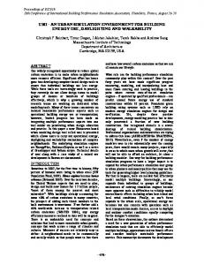
The vast majority of fire spread simulators use the thirteen fuel models stated by Rothermel (1983), this models can be inferred from Soil Cover Models and a mapping dictionary to convert this cover information to the fuel models used in the simulator. Figure 1 shows the process to obtain a geospatial database with fuel model information. Almost every environmental agency can provide this kind of information; in the Catalonia case the research team CREAF manages the creation and validation of cover models. These models are segmented in regions of 127 km2 (approx.) that have been imported to a PostGIS database to create spatial continuity for the simulator.
Figure 1: Fire Models extraction process.
1951
Figueras, Guasch, Fonseca, and Casanovas 2.2
Fuel Moistures
According to Chandler, Cheney, Thomas, Trabaud and Williams (1983) "the history of attempts to accurately predict fuel moisture contents of forest fuels have been an endless series of beautiful theories demolished by ugly facts". Verbesselt J. (2002) propose and analyses different methodologies for fuel moisture estimation, but since it is known that any modeling methodology to model fuel moistures will lead in modeling errors, the Rothermel (1983) estimation of fuel moistures will be used because of its simplicity and easiness of implementation. 2.3
Digital Elevation Models (DEM)
DEMs are required to calculate the terrain slopes and aspects. This calculation can be done by any GIS tool. Worldwide DEM can be obtained with low resolutions through ASTER GDEM or SRTM DEM. Local agencies can provide more accurate DEMs. In the case of Catalonia, local cartographic agency, ICC provides a 5x5m and 15x15 DEM that will be used in our test bed. 2.4
Wind Intensity and Direction
Wind data is a time dependent information that, in the most favorable case, is sampled at regular times in a certain locations, always out of the burning area. So an interpolation has to be applied to approximate wind conditions in the burning area. Different studies talk about spatial interpolation techniques of wind intensity and direction such as Atkinson and Lloyd (1998) or Stepek and Wijnant (2011). Comparison between them leads us that kriging techniques, specifically co-kriging Meyers (1985) lead with best results. Worldwide data sources can be obtained through the METAR information archives REFERENCIAR and for the Catalonia case, the MeteoCat Governmental agency provide meteorological information that will be used. 2.5
Highway, Track and Path Information
Apart from environment data, for fire spread simulation resource simulation needs its own set of data. Beginning with road network data, the only reliable worldwide and open source of information is OpenStreetMap (OSM). OSM is intended as a free online wikimap that models any geographical information, from road network to waste baskets. So a data processing and analyzing tool have to be developed in order to extract road geographical information and convert it to a graph able to calculate optimal routes with it. The information suitable for the simulation environment is the related to roads, tracks, and paths. Roads and tracks are needed to provide routes to firefighting vehicles and paths are needed for firefighters to access to the wildfire flanks more efficiently than through the forest 2.6
Water Resources Location
Water resources spot information, such as hydrants, water tanks or swimming pools are needed because they are the locations where engines and tankers can refill its tanks and establish a water provisioning line to the engines feeding the laid hoses in the fire line. Again the only worldwide source of information is OSM. Whilst in the Catalonia case, the National Cadaster Agency can provide this type of information. 2.7
Available Firefighting Resources
The available firefighting resources information is needed to select the most convenient crew and engines and deploy them to the fire line. While station information can be found in OSM, for human and material resources there is no other source of information than the local and national security agencies. So in the Catalonia case this information is provided by the Catalan Firefight Department.
1952
Figueras, Guasch, Fonseca, and Casanovas 2.8
Data Management
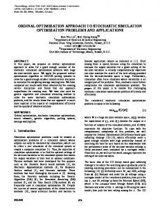
All the needed data described previously has to be managed and stored. As it comes from many sources it is presented using many different formats and many of them without any standard. So it is needed a processing tool to homogenize this information and convert it to a standard. In the geo-information area the Open Geospatial Consortium (OGC) is the organization that provides consensus standards. Also the Open Source Geospatial Foundation (OSGeo) implements the standards, tools and libraries to use them. For this environment we decided to store all the information described previously using a PostGIS Database developed by OSGeo, following the OGC Standards. This way, following the OGC standards, the environment can easily interoperate with any other software or source of information. Figure 2 shows the data processing schema
Figure 2: Geospatial data processing schema following OGC Standards Several conversion tools have been yet implemented suche as an OpenStreetMap road, track and path convertor. This tool has been designed to use OSM XML format to convert it to a routing graph. As an example the data format and data ontologies can be retrieved from OSM wiki pages. Another tool that has been implemented is the data extraction from the Catalan Firefight Department, this information is stored in different daily Access databases. These tools has been implemented with the python programming language as it is an easy tool that combines the power of the programming libraries and the capacity to deal with complex math. 3
ENVIRONMENTAL MODELLING
As seen in section 2, several sources of information are needed to simulate a fire event and to simulate and optimize fire contention resources. All this information is treated and stored in an OGC standard geospatial database (improving interoperability between applications). Accessing information is done through an API using OGC standards for geo-information. A forest event data format Nader, Filippi, and Bisgambiglia (2011) was proposed using NetCDF container Rew and Davis (1990) and outputs to KML format. KML Format is an OGC geo-information standard so we follow this proposal to output forest event data from the geospatial database. 4
NON ENVIRONMENTAL ELEMENTS MODELLING AND DATA FORMAT
A glossary is a list of terms for a specific domain of knowledge with the definitions or the explanation for those terms. For resource modeling this data is based on properties of the elements and resources.
1953
Figueras, Guasch, Fonseca, and Casanovas 4.1
Highway, Track and Path Information
Highway information storage can be optimized using only the length and starting and ending nodes to build the network graph for routing purposes. Other information such as maximum speed, turning restrictions and others can be discarded because fire engines avoid any restriction in case of emergency and fire engines can't develop high speeds. Table 1: Glossary of highway information necessary to route fire engines Data Length Geometry Start Node End Node
Explanation Distance of the roadway segment Shape of the roadway ID of the starting point of the roadway segment ID of the ending point of the roadway segment
Format Double OGC linestring Integer Integer
Units meters -
In wildfire situations it is very important to place fire engines as near as possible to the fire front in order to optimize the deployment of the firefighter crew. So, additional information about track conditions is needed to determine if a fire engine can use a track or not. Table 2: Glossary of track information necessary to route fire engines Data Length Geometry Start Node End Node Track Type Surface Smoothness
Explanation Distance of the roadway segment Shape of the roadway ID of the starting point of the roadway segment ID of the ending point of the roadway segment Measure of how well-maintained a track is. Information about the physical surface of the track Classification scheme regarding the physical usability of a way for wheeled vehicles
Format Double OGC linestring Integer Integer Integer [1..5] Struct Struct
Units meters -
Firefighter teams deploy hoses from the engine to the attack point in the fire front. Depending on the existence of paths or cross country to reach the fire front the deployment time of the fire line will vary. Table 3: Glossary of path information necessary to route firefighter crew Data Length Geometry Start Node End Node Surface SAC Scale
Trail Visibility Incline
Explanation Distance of the roadway segment Shape of the roadway ID of the starting point of the roadway segment ID of the ending point of the roadway segment information about the physical surface of the track classification scheme for hiking trails that describes attributes regarding difficulty. It is based on the Klassifikation des Swiss Alpine Club (SAC) since there is no internationally standardized classification schema. This key describes attributes regarding trail visibility (not route visibility) and orientation For marking a way's incline (or steepness/slope)
1954
Format Double OGC linestring Integer Integer Struct Struct
Units meters -
Struct
-
Double
%
Figueras, Guasch, Fonseca, and Casanovas 4.2
Water Resources
Hydrants are the main source of water to fire engines and fire tankers; although nearly all of them are standardized it is necessary to double check the type and condition of the hydrant to avoid deployment of tankers to a useless hydrant breaking the water provisioning chain. Table 4: Glossary of hydrant properties Data Location Type Pressure
Explanation Location of the fire hydrant Pressure or suction hydrant Pressure of water or suction pressure for dry hydrants
Format OGC point Struct Double
Units meters bar
Swimming pools, rural and forest tanks are other main sources of water in wildfire events. It is important to determine the capacity and type of access to plan a water provisioning chain. Table 5: Glossary of water pools and tanks Data Location Type Covered Capacity 4.3
Explanation Location of the swimming pool or tank Swimming pool or Tank Is the swimming pool or tank covered or inside a building Volume of water available
Format OGC point Struct Boolean
Units meters -
Integer
liters
Firefighting Resources
Fire engines and firefighters are the key part in any fire. To calculate if a team can reach the fire front and perform de suppression procedures, hose types and lengths, fire line deployment, time to finish water, production rate of the team, etc. is the information needed to calculate the extinguished area and plan supply chains. These calculations will be used by the fire spread simulator and evaluated by the optimizer to decide if a certain deployment assesses the objective. Table 6: Glossary of needed information to deploy Fire engines Data Type Water Capacity Pump flow Hoses Crew capacity Max Speed AWD
Explanation Type of firefight engine Capacity of water Nominal flow of water through the pumps Vector containing the hose information: length, diameter and quantity Number of firefighters the engine can carry Maximum speed of the fire engine in a highway at full capacity of water Capacity of the engine to move in tracks
Format Struct Integer Integer Struct
Units l l/min -
Integer Integer
Km/h
Boolean
-
Table 7: Glossary of needed information to deploy Firefighter teams to the fire front. Data Firefighter Team Type Rate Shift Shift Start Size
Explanation Function assigned to a firefighter team Production Rate Working shift length Date and Time where the firefighter team shift started Number of firefighters in the team
1955
Format Struct Double Double DateTime Integer
Units m/min hours -
Figueras, Guasch, Fonseca, and Casanovas 5
FIREFIGHT PROJECT ARCHITECTURE
The experimental environment project architecture is shown in Figure 3. It is mainly composed by an optimizer to search for a best fire attack policy with support of fire spread and suppression simulation.
Figure 3: Architecture of the proposed environment. Web GUI: The FireFIGHT project will have a GUI to interact with the user. The capabilities of this GUI are: Define a wildfire scenario; Start/Stop of the simulation processes; Event reproduction. Fire Scenario: A fire scenario consists of the information defined by Nader, Filippi, and Bisgambiglia (2011) this information is read by the GUI who tells the controller to generate the scenario from the geospatial database. Controller: Is the process in charge of synchronizing the different processes of the application. First, to control the reality Fire spread simulator to predict how real fire will behave, then activating the optimizer to search for feasible plans. Then activate the proposed plans simulator to evaluate how effective are the feasible plans proposed and select the best solution from the proposed and finally tell the reality simulator to execute the plan. Fire Spread Simulator (reality): its function is to simulate a real fire applying the best tactics proposed by the optimizers Optimizer: It is designed to search the best feasible solutions from a set of fire suppression tactics and available resources Feasible Plans: Are the set of feasible solutions the optimizer find that have to be simulated in order to evaluate its goodness. 1956
Figueras, Guasch, Fonseca, and Casanovas Best Plan: Is the best feasible solution proposed by the optimizer that has to be implemented by the firefighters. This best solution is used by the reality simulator. Fire Spread Simulator (proposed plans): This simulator function is to develop the behavior of the fire spread and fire suppression in order to test a feasible plan Results: Are the output of the fire spread and suppression simulator for the proposed plans. This results guide the optimizer to find a good solution. 6
FIRE SPREAD AND CONTAINMENT SIMULATION
Simulation in this environment has two functions. First to simulate the reality as a substitute of a real fire event, this mean that this simulator does not use any forecast and will use historical data to reproduce past fire events. Second to simulate the proposed plans calculated by the optimizer, in this case the simulator has to predict the behavior of the fire spread and suppression according to the plan. It has to forecast weather and evolution of firefighting crews in the fire front. Using this scheme the reality simulator can be removed and substituted by a real fire scenario. But the need of a simulator is mandatory when reproduction of past fire events, because the proposed actions by the optimizer will differ from real decisions conducted by firefighter manager. So the evolution of the fire front will be different. The proposed plans simulator is the tool to predict the fire behavior when applying the optimizer decisions and the results of these simulations are used to calculate and evaluate the objective function of the optimizer. Our proposed simulator, in difference with actual simulators, has to deal with lack of real resources, such as water or workinking shifts. As an example, actual simulators deal with fire containment developing a fire-line around the fire contour with a certain production rate, they do not deal with hose length and deployment time or with the water tank capacity of the punping vehicle and its provisioning line. Our proposed work deals with this information (that is supervised by the Catalan Firefight Department). The selection of the appropriate tool for simulation depends on the ability of the simulator to be programmatically stopped, the ability to modify in runtime the behavior of the firefighting crews and the ability to modify the environmental variables in runtime. There requirements narrow the candidates because none of the state of the art simulators allow our necessities. The access to source code of the simulator to adapt to our requirements makes FARSITE the more convenient simulator. 7
OPTIMIZATION
Wildfire managers are responsible for making decisions regarding wildfire containment. In the event of a reported wildfire, they select what firefighting resources at each base should be dispatched to the wildfire and generate a plan of action and firefighting tactics to employ. Taking such decisions is difficult due to the short time available for decision-making, dynamical an uncertain fire behavior, and limited firefighting resources. The goal of the optimizer is to provide an optimal set of decision to improve wildfire containment. Different multicriteria optimization algorithms are being developed to determine which is better to minimize the non-efficient movements of material, and people. The variables used in the optimizer objective function are: - Duration of fire - Fire front perimeter - Number of resources - Fire line length - Travelled distance Under the constraints: - Continuity of the water provisioning chains 1957
Figueras, Guasch, Fonseca, and Casanovas The optimization process is an adaptive procedure that iterates as follow: Applying different firefighting tactics and different algorithms in the selection of feasible solutions lead the optimization process to different firefighting plans. These plans are then simulated to evaluate its goodness in a fixed time horizon. The best found solution is then applied for a time step by the real simulator. The output of the simulator is the input for the next optimization. 8
ACTUAL RESULTS
This paper presents a work in progress. Nowadays the development process is at stage of developing the fire spread and containment simulator. This simulator is being developed with a server-client structure where the client is a web-browser. As shown in figure 4 an animation of the fire resources in a fire scenario is shown.
Figure 4: Deployment of firefighting resources 9
SUMMARY AND CONCLUSIONS
This paper presents the FireFIGHT experimental environment architecture for planning an optimal deployment and management for wildfire containment and suppression. The system will use real data from different sources of information. The optimization and simulation framework is designed to be interoperable with different systems due to the use of standardized information. The use of different simulators, representing the fire forecast and the fire reality make the system robust to changes and allowing the optimizer to adapt to new realities. The results of this project will be used by the firefighting department of Catalonia with training purposes. ACKNOWLEDGMENTS This work has been funded by the Ministerio de Ciencia e Innovación, Spain. Project reference TIN201129494-C03-03. REFERENCES ASTER GDEM, 2011. “Global Digital http://gdem.ersdac.jspacesystems.or.jp/
Elevation 1958
Model.”
Last
Updated
October
2011,
Figueras, Guasch, Fonseca, and Casanovas Atkinson P.M., and C. D, Lloyd. 1998. “Mapping precipitation in Switzerland with ordinary and indicator kriging.” Journal of geographic information and decision analysis. No. 2:65-68. Chandler C., P. Cheney, P. Thomas, L. Trabaud, and D. Williams. 1983. “Fire in forestry: forest fire behavior and effects.” John Wiley and Sons, New York. CREAF 2009. “Mapa de Cobertes del Sòl de Catalunya.” Last updated November 2012, http://www.creaf.uab.es/mcsc/ Donovan G, and B. Rideout. 2003. “An Integer Programming Model to Optimize Resource Allocation for Wildfire Containment” Forest Science, Vol. 49, No. 2: 331-335 fiResponse, 2013. “Enterprise wide incident management & resource tracking decision support” http://firesponse.com/ Haight R., and J. Fried. 2007. “Deploying Wildland Fire Suppression Resources with a Scenario-Based Standard Response Model” INFOR, Vol. 45, No. 1: 31-39 Hu X., and L. Ntaimo. 2009. “Integrated Simulation and Optimization for Wildfire Containment” The ACM Transactions on Modeling and Computer Simulation (TOMACS), Vol. 19, No. 4: 19.1-19.29 ICC DEM. 2011. “Model d’Elevacions del Terreny de Catalunya 15x15 metres (MET-15) v2.0” Last Updated June 2011. http://www.icc.cat/vissir3/ MeteoCat. 2013. “Xarxa d’estacions meteorològiques automàtiques” Last Update: 10 minutely. http://www.meteo.cat/xema/AppJava/SeleccioPerComarca.do Meyers D. 1985. “Co-Kriging: Methods and alternatives.” The Role of Data in Scientific Progress, Elsevier Science Publishers. 425-428 Moura D., and E. Oliveira. 2007. “Fighting Fire with Agents - An Agent Coordination Model for Simulated Firefighting” ADS07 Conference, Universidade do Porto. Open Geospatial Consortium. “Geospatial and location Standards” http://www.opengeospatial.org/ OpenStreetMap. “OpenStreetMap, The wiki world map.” http://www.openstreetmap.org/ OSGeo. “Open Source Geospatial Foundation” http://www.osgeo.org/ Rothermel R. 1983. “How to Predict the Spread and Intensity of Forest and Range Fires.” SDA, Forest Service, Intermountain Forest and Range Experiment Station, General Technical Report INT-143, Ogden, Utah. 163p. SRTM. 2000. “Shuttle Radar Topography Mission.” Last Updated January 2009. http://www2.jpl.nasa.gov/srtm/ Stepek A., and I. Wijnant. 2011 “Interpolating wind speed normals from the sparse Dutch network to a high resolution grid using local roughness from land use maps.” Koninklijk Nederlands Meteorologisch Instituut, Technical Report TR-321 Verbesselt J, S. Fleck and P. Coppin. 2002. “Estimation of fuel moisture content towards Fire Risk Assessment: A review.” Forest Fire Research & Wildland Fire Safety, Viegas (ed.) Millpress, Rotterdam Rew, R. K., and G. P. Davis. 1990. “The unidata netCDF: Software for scientific data access”. In Sixth International Conference on Interactive Information and Processing Systems for Meteorology, Oceanography, and Hydrology, Anaheim, California, American Meteorology Society, 33–40. AUTHOR BIOGRAPHIES JAUME FIGUERAS born in 1974 had his degree in Computer Science in 1998. His research is in Automatic Control and Computer Simulation and Optimization. He has designed and developed CORAL, an optimal control system for sewer networks, applied at Barcelona (Spain); PLIO, an optimal control system and planner for drinking water production and distribution, applied at Santiago de Chile (Chile) and Murcia (Spain). Nowadays He participates in different industrial projects, like the power consumption optimization of tramway lines in Barcelona with TRAM and SIEMENS and the development of tooPath (http://www.toopath.com) a free web tracking system of mobile devices. He is also the local representa1959
Figueras, Guasch, Fonseca, and Casanovas tive of OSM (http://www.openstreetmap.org) in Catalonia and participates in different FOSS projects. His email address is
[email protected] ANTONI GUASCH is a research engineer focusing on modelling, simulation and optimization of dynamic systems. He received his Ph.D. from the UPC in 1987. He is an Associate Professor in the department of "Ingeniería de Sistemas, Automática e Informática Industrial" in the UPC and head of Simulation and Industrial Optimization at inLab FIB (http://inlab.fib.upc.edu/). Since 1990, Prof Guasch has lead more than 40 industrial and research projects related with modelling, simulation and optimization of nuclear, textile, transportation, car manufacturing, water, pharmaceutical and steel industrial processes. His email address is
[email protected] PAU FONSECA is Professor of the Statistics and Operations Research Department of the Universitat Politècnica de Catalunya BarcelonaTECH and a Researcher of the inLab. He holds a Ph.D. in Statistics and Operations Research and a M.S. in Computer Science. He participates in several competitive projects related to simulation and technology transfer, like the simulation of the International Airport of Barcelona, or the simulation of Almirall Prodesfarma enterprise. His research interest includes environmental and social simulation, and formal representation of simulation models, interest that leads him to collaborate with the ITU‐T in the definition of the new version of the Specification and Description Language (SDL‐ 2010). His email address is
[email protected] JOSEP CASANOVAS Professor Josep Casanovas (Ph.D. in Computer Science, Industrial Engineer, MSc in Economics) is the head of inLab FIB, formerly called LCFIB, at Barcelona School of Informatics. He is a full professor of the Statistics and Operations Research Department at UPC. His main research areas are Modeling and Simulation, Internet and Information Systems. He is the author of numerous research articles and has collaborated in the development of many projects for the European Union and other companies and institutions. Between 1998 and 2004 he was dean of the Barcelona School of Informatics. In addition, Prof. Casanovas has been vice-rector of university policies of the Technical University of Catalonia (2006-2011). He was also responsible for ICT policies at UPC. Currently, Josep Casanovas is co-director of LogiSim (Centre of Simulation and Optimization of Logistic Systems) and coordinator of the Severo Ochoa Research Excellence Program in the Barcelona Supercomputing Center (BSC-CNS). His email address is
[email protected]
1960