Vie et milieu - life and environment, 2008, 58 (1) : 25-35
SPATIAL PATTERNS OF SOFT-BOTTOM MACRO-INVERTEBRATES AND RELATIONSHIPS WITH ENVIRONMENTAL CONDITIONS IN A NORTH AFRICAN COASTAL LAGOON (SMIR LAGOON, MOROCCO) A. CHAOUTI , A. BAYED Unité de Recherche “OCEMAR”, Université Mohammed V - Agdal, Institut Scientifique, Avenue Ibn Battota, B.P. 703, 10106 Rabat, Morocco Corresponding author:
[email protected]
MEDITERRANEAN SHALLOW-WATER ECOSYSTEM MACROBENTHIC COMMUNITY SPECIES DIVERSITY TROPHIC STRUCTURE COMMUNITY HEALTH
Abstract. – Macrobenthic communities of the Smir lagoon on the western Mediterranean Moroccan coast are described in relation to the environmental conditions. Macrofauna was organised in three communities: the Corophium acherusicum community, the Melita palmata community, and the Cyathura carinata community subdivided in two sub-communities. Results show that: (i) the distribution of macrobenthic assemblages was roughly determined by the vegetation as major structuring factor and by sediment, pH and dissolved oxygen; (ii) the overall faunal composition, species distribution and community structure in the Smir lagoon were comparable to those reported for other Moroccan brackish ecosystems; (iii) the trophic structure was exclusively dominated by detritivores and (iv), the lagoon was a slightly disturbed ecosystem with unbalanced communities.
Introduction Coastal lagoons are highly productive ecosystems. Due to their position, they are often nutrient rich (Colombo 1977) as a result of continental inputs and recycling processes occurring in the coastal zone (Nowicki & Nixon 1985). These areas have a considerable ecological value but may also play an important economic role. Because of their high productivity and geomorphological features, they are important nursery areas and usually present good conditions for aquaculture and fishing practices. Coastal lagoons are, however, exposed to increasing anthropogenic pressures, which ultimately may lead to complete changes in their status and dynamics. Because of its reduced mobility and long life span, the macrobenthos is often used as an index of healthiness for aquatic ecosystems. The quantitative description of the distribution patterns across different spatial and/or temporal scales allows for the understanding of the processes that structure macrobenthic assemblages (Constable 1999). This approach is suitable to predict environmental changes due to anthropogenic impacts (Ysebaert & Herman 2002) especially for lagoon ecosystems, which are characterised by a high degree of variability. The lagoon of Smir, located on the western Moroccan Mediterranean coast, is characterized by a high diversity of habitats within a complex of natural and artificial wetlands (marshes, merjas, drainage channels, beach, wadi, channels, dam,…). This site is an exceptional place for many animal and plant species of great interest for Moroccan, North African and/or Mediterranean biodiversity. Because of its geographical position on the northwestern coast of Morocco close to the Gibraltar strait, the Smir
lagoon undergoes the influence of both the Mediterranean Sea and the Atlantic Ocean. This dual influence generates particular ecological conditions as compared to the other Moroccan lagoons (Nador, Merja Zerga, Walidia and Khnifiss lagoons). This fact also explains why the Smir lagoon does not have a typical Mediterranean macrozoobenthic community (Chaouti 2003, Chaouti & Bayed 2005a). Since the construction of a dam on the upper section of Oued Smir (river) in 1991 and the establishment of a recreational port in its downstream section, the salinity of the lagoon’s water body has progressively increased. This process has led to an evident change in ecosystem functioning (Chaouti & Bayed 2005b). Before the dam’s construction, Smir lagoon was functioning as an estuarine lagoon (classification of Postma 1969). When the dam was built, the ecosystem progressively evolved toward a neutral type lagoon. Water movement was exclusively assured by the tide, and salinity in the lagoon became similar to that of the sea. This increase in salinity clearly influenced the composition, structure and functioning of the biological component and there was a progressive colonisation of the halophytic vegetation in the marshes and the disappearance of freshwater species from the lagoon’s water body (Bayed & Chaouti 2005). Although a significant scientific effort has been brought to study the macro-invertebrates, the macrozoobenthic community remained poorly known. This work aims at identifying the macrofaunal assemblages of the Smir lagoon and at studying the environmental structuring factors.
26
A. CHAOUTI, A. BAYED
MATERIAL AND METHODS Study site: The lagoon of Smir is a microtidale coastal lagoon located at the northwest of Morocco at approximately 25 km to the south of the Gibraltar strait and at about 15 km to the north of the city of Tetouan (Fig. 1). Its geographical position (35°43’ N and 5°20’ W) makes it the most western lagoon along the Moroccan Mediterranean coast. The prevailing climate in this region is a Mediterranean type climate characterised by severe winter rains and by long summer dryness (from June to September). The mean annual rainfall is higher than 600 mm (distributed between October and April) with a mean annual temperature not exceeding 16°C. In terms of bioclimatology, the region of Smir belongs to the sub-humid stage. The lagoon covers an area of about 3 km2. Its maximal depth is 2 m with an average depth of 0.5 m, and it is separated from the sea by the recreational port of Kabila. Tide seawater enters the lagoon through a very narrow entrance. The tide is semidiurnal with an average tidal range of 1 m. Freshwater inflows are scarce (Bayed & Chaouti 2005) and are mostly located in the northern area of the lagoon. These are mainly assured by the Oued Smir. The bottom sediments mainly consist of a muddy soft substrate and the few sandy zones are mainly concentrated as a sandbank close to the entrance. Extensive algae (Gracillaria verrucosa, Enteromorpha linza, Ulva lactuca, Ulva rigida, Potamogeton pectinatus,…), and seagrass beds (Zostera noltii and Ruppia cirrhosa) (Benhissoune et al. 2005) cover almost completely the bottom of the downstream area. The hydrological conditions of the lagoon mainly depend on regular marine supplies (tides), on the one hand, and on occasional freshwater inflows on the other. These are the waters coming from the Oued Smir, which have greatly decreased since the construction of the dam and from a channel coming from the marshes. This channel lies between the lagoon’s water body and the town of M’diq, located to the south of the study area (Chaouti 2003). Salinity in the lagoon generally ranges between 30 and 40 PSU, but it can drop to 5 PSU during floods by the marsh
channel and the Oued Smir. The combination of seawater and freshwater inflows together with the dominant winds, particularly those blowing from east in summer, produce a salinity gradient with values increasing from the lagoon’s outlet to the inner area (Chaouti & Bayed 2005b). Tidal currents tend to invade the whole lagoon, all the way up to the channel at a distance of 2-3 km from its outlet and to gain more and more space in marshes. Water quality of the lagoon and the adjacent marshes is also affected by solid and liquid wastes. These are mainly produced by the town of M’diq and the tourist accomodations of Kabila during summer time. Sampling procedure: During May 2000 the macrofauna was studied at 22 stations chosen in vegetated and unvegetated areas of the Smir lagoon (Fig. 1). At each station, four replicates were taken at a depth of 30 cm, using a corer with a sampling surface of 1/16 m2. Samples were sieved in situ through a 1-mm2 mesh size and fixed in 8 % buffered formalin for later sorting, identification and counting of the macrofauna. An additional sediment sample was taken for grain size analysis and for estimation of the total organic matter (burning samples in a furnace at 650°C for 6 hours). The sediment samples were represented on the triangular diagram according to three sedimentary fractions: fine particles or silt, fine sand and coarse sands, and gravels. Median grain size was estimated for each sample and sedimentary types were characterised according to Chassé & Glémarec (1976). The chemical and physical factors such as salinity, temperature, pH and dissolved oxygen of the water near the bottom, and temperature of the sediment at a depth of 5 cm, were measured at each station during spring tides. Data analysis: Macrofaunal communities were analysed using multivariate techniques of classification and ordination. A matrix of abundance was analysed, after log(x+1) transformation of the faunal data, to point out rarer taxa and to prevent few abundant species from dominating the analyses. First the
Fig. 1. – The Smir lagoon location and sampling stations.
Vie Milieu, 2008, 58 (1)
MACROFAUNAL COMMUNITIES OF SMIR LAGOON
Ascending Hierarchical Classification ‘AHC’ (Lebart et al. 1982) was applied. This was based on the Euclidian distance and “complete linkage” diameter as criteria of aggregation. The analysis was carried out on a binary matrix sampling ‘stations/ species’ using abundance (ind./m2) as the basic element. Then Factorial Correspondences Analysis ‘FCA’ (Benzecri 1973) was applied on the same matrix so as to recognise the existing ecological gradients. Significant correlations between environmental variables and factorial axes were found through Spearman’s rank coefficient (rs). The significance of rs was tested from the data matrix (22 stations x 17 species). Significant levels of probability were considered when p < 0.05 and values of rs were significant when higher than 0.4227. Macrobenthic communities were described through species richness (S), abundance (A), Shannon-Wiener diversity index (H’, as log2) (Shannon & Weaver 1963) and evenness index (J’) (Pielou 1966). The FDM coefficient (Frequency x Mean Dominance) (Glémarec 1964) was calculated for each species in each assemblage. The community description was based on the identification of leader species with the highest FDM. The functional structure analysis was performed on the basis of the trophic groups of the different macrobenthic taxa. Each feeding guild was identified according to the behaviour and the feeding habits. The classification of Hily & Bouteille (1999) was considered taking into account food nature and size and its collection mode. The ecological quality status of sampled stations in the Smir lagoon was determined using the AZTI Marine Biotic Index ’AMBI’ (Borja et al. 2000). The assignment of the identified species to one of the five ecological groups proposed by the AMBI was based upon the list available in the AMBI program (http://www.azti.es).
27
Salinity showed high fluctuations and ranged between 24.9 PSU (S1) to 36.5 PSU (S22) (Table I). The water temperature exhibited a parallel evolution with the interstitial temperature (r = 0.96; p < 0.05) and both ranged from 17.8 to 20.8°C and from 18.8 to 20.3°C, respectively (Table I). The pH showed a mean value of 8.3 ± 0.1 and dissolved oxygen ranged from 7.5 to 14.8 mg/l. Macrofaunal analysis AHC was performed from a matrix of 22 stations and 17 species (five taxa were removed because they were recorded only once in all samples). Four groups of stations were identified (Fig. 3) and labelled as GSI (S1, S2, S3, S4, S10 and S11), GSII (S14, S15 and S22), GSIII (S5, S6, S7, S8, S9, S12 and S13) and GSIV (S16, S17, S18, S19, S20 and S21), respectively. FCA analysis carried out on the same data matrix clearly produced the same groups of stations identified by AHC (Fig. 4) when the factorial plan F1xF2 was considered (39.7 % and 24.8 % of the total inertia of F1 and F2 axes, respectively). The spatial position of the station assemblages in the lagoon is mapped in Fig. 5. Except for the stations S4 (fine mud) and S11 (muddy fine sand), the stations isolated in the positive values of F1 corresponded to sandy mud with fine particle content not exceeding 50 %, total organic matter content lower than 8 % and a poor or absent vegetation. The second group of stations in the negative values of F1 were generally characterised by fine mud substrate with a high percentage of fine particles (> 50 %), by a total organic matter content that could exceed 13 % (mean value 10.3 ± 3.4 %) and by a well developed vegetation cover. The above-
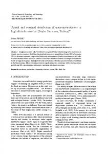
RESULTS Environmental features Three sedimentary groups were identified on the triangular diagram (Fig. 2): Fine and silty (stations 4, 7, 8, 9, 12, 16, 17, 18 and 19): the mean ratio of silt material was of 68.5 ± 10.6 % and the median grain size was lower than 63 µm. This sediment showed a high organic matter content that ranged between 8 % (S4) and 13.5 % (S9) (Table I). Sandy mud (stations 1, 2, 3, 5, 6, 10, 13, 14, 15, 20, 21 and 22): the amount of fine particles was less than 50 % with a fine sand content varying from 47.7 % (S10) to 63.1 % (S3) and a median grain size between 75 µm (S10) and 166 µm (S6). The organic matter content was lower than 8 % (Table I). Muddy fine sand (station 11): the silt particles were equal to 23.4 % with a median grain size of 205 µm. The organic matter content (Table I) was at the lowest value (3.5 %) compared to the other identified sedimentary types.
Fig. 2. – Position of the sediment of each sampling station in the Smir lagoon represented in the ternary diagram with poles constituted by fine particles (FP), fine sand (FS) and coarse sand and gravel (CSG) fractions.
Vie Milieu, 2008, 58 (1)
28
A. CHAOUTI, A. BAYED
Table I. – Abiotic variables measured in sampling stations in the Smir lagoon with mean values (Mean) and standard deviation (Std). Te = water temperature, Sal = salinity, Dis Ox = dissolved oxygen, Ts = sediment temperature, Md = median grain size, TOM = total organic matter, VC = vegetation cover; 0 = absent, - = scarce, + = low density, +++ = high density.
Fig. 3. – Dendrogram of Cluster Analysis of the 22 stations based on the calculation of the Euclidian distance between stations.
Vie Milieu, 2008, 58 (1)
MACROFAUNAL COMMUNITIES OF SMIR LAGOON
29
Fig. 4. – Representation of groups of stations (S1 to S22) and significant species in the space of the first two dimensions of the factorial correspondence analysis. Species code letters as in Table III.
mentioned groups of stations were then divided in two subgroups according to the F2 axis (Fig. 4). The unvegetated group of stations included a group of peripheral stations and another one located in the lagoon’s inner channel. The vegetated stations, forming the second group, were subdivided in upstream and downstream stations. The latter contained a peripheral station, S5, characterised by a sandy mud substrate and by a dense vegetation cover similar to the one occurring in the downstream stations (Table I). Correlations between the FCA axes and the environmental factors through Spearman’s rank coefficient (Table II) showed that the F2 axis was correlated to some hydrological parameters such as pH and dissolved oxygen to which sediment temperature could be added (rs = 0.537; p