SSN & STARS: Tools for Spatial Statistical Modeling on Stream Networks •Stream temperature and water quality parameters •Species distributions and abundance •Channel habitat conditions Key Points: Network structure, connectivity, and flow direction strongly affect spatial patterns in stream attributes. Most statistical analyses ignore network structure and may provide biased results for stream data. A new class of statistical model for stream networks has been developed that is applicable to most types of stream data and provides more accurate and new types of information when data are spatially correlated. Freeware GIS tools and statistical programs for running the network models are available through a USFS website.
Stream networks have properties such as dendritic branching, directed flow, and abrupt changes in physical, chemical and biological attributes at tributary junctions. Traditional forms of statistical analyses for stream data ignore these properties, which increases the chances of obtaining biased results and poor scientific inference. Researchers at NOAA and CSIRO have developed a new class of spatial statistical model for data measured on stream networks that provides more accurate and new types of information when data are spatially correlated. These models are a form of universal kriging, but have a covariance model that accurately represents stream network structure. Stream network models can be used with any type of data collected on streams, including distribution, abundance, and genetic attributes of aquatic organisms, stream temperature and water quality parameters, or channel habitat characteristics. Another powerful feature of the models is that they account for spatial relationships and potential redundancies among data observations by weighting the amount of information that each observation contains. As a result, accurate inference and predictions can be obtained from databases that are characterized by non-randomness and spatial clustering. In practical terms, this means that new information can be developed at low cost from aggregating existing databases, resource agencies can more easily share data, and many new types of sampling design are possible. Implementing a spatial statistical stream network model is more complex than traditional analyses but freeware tools have been developed to assist new users. These tools are distributed through the “SSN and STARS” website hosted by the U.S. Forest Service, Boise Aquatic Science Lab. Visitors to the website can download GIS tools, statistical software, tutorials, and example datasets. For additional information, please contact the science team members on the next page or send an email to
[email protected].
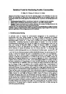
Figure 1. Spatial statistical stream network models can use data from a relatively small number of sites (left panel) to make unbiased predictions across larger river networks (right panel).
Science Briefing Paper http://www.fs.fed.us/rm/boise/awae_home.shtml
Page 1
Figure 2. Statistical stream models accurately represent spatial patterns on stream networks by incorporating covariance structures that recognize the direction of stream flow and changes at tributary junctions (inset). The models also portray spatial variation in the precision of model predictions (shading around small circles) based on the distance to sites with data (large circles) used to develop a model. Visit the SSN and STARS website (http:// www.fs.fed.us/rm/boise/AW AE/projects/ SpatialStreamNetworks.shtml) for more information or to download freeware statistical software, GIS tools, example datasets, and tutorials.
Relevant Publications Peterson, E.E., and J.M. Ver Hoef. 2012. STARS: An ArcGIS toolset used to calculate the spatial data needed to fit spatial statistical models to stream network data. Journal of Statistical Software x:xxx-xxx. Peterson, E.E., and J.M. Ver Hoef. 2010. A mixed-model moving-average approach to geostatistical modeling in stream networks. Ecology 91:644-651. Ver Hoef, J.M., E.E. Peterson, D. Clifford, and R. Shah. 2012. SSN: An R package for spatial statistical modeling on stream networks. Journal of Statistical Software x:xxx-xxx. Ver Hoef, J.M., and E.E. Peterson. 2010. A moving average approach for spatial statistical models of stream networks. Journal of the American Statistical Association 105:6-18. Ver Hoef, J.M., E.E. Peterson, and D.M. Theobald. 2006. Spatial statistical models that use flow and stream distance. Environmental and Ecological Statistics 13:449–464. Example application: Isaak, D.J., C. Luce, B.E. Rieman, D. Nagel, E. Peterson, D. Horan, S. Parkes, and G. Chandler. 2010. Effects of climate change and recent wildfires on stream temperature and thermal habitat for two salmonids in a mountain river network. Ecological Applications 20:1350-1371. Project Science Team Jay Ver Hoef Statistical Ecologist NOAA Marine Mammal Laboratory Fairbanks, Alaska
[email protected] http://www.fs.fed.us/rm/boise/awae_home.shtml
Erin Peterson Spatial stream ecologist CSIRO Division of Mathematics Dutton Park, Australia
[email protected]
Dan Isaak Fisheries Scientist U.S. Forest Service Phone: 208.373.4385 Email:
[email protected]
Page 2