http://gis.ny.gov/gisdata/inventories/details.cfm?DSID=932 ... geocoded using NYC Dept of. City Planning Geosupport ... Department of. Sanitation inspections of.
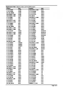
Supplemental Table 1 - Details on GIS-based source indicators Source Category
Traffic Indicators
Population Metrics
Built Space
Data Source New York Metropolitan Transportation Council (NYMTC) traffic data,2005 U.S. Federal Highway Administration Highway Performance Monitoring System (HPMS) data, 2007 Accident Location Information System (ALIS) road network data, 2008
Resolution/positional accuracy Link level data assigned to street centerline data generated by Tele Atlas Data linked to National Highway Planning Network line file; accuracy +- 80m
+/- 40 ft
MPSI TrafficMetrix TM data, 1989-2006
Linked to ALIS road network
NYC Department of Transportation (DOT) traffic signals, truck and bus routes, 2008
Truck and bus routes aligned to aerial imagery with +/-2 ft resolution; traffic signals geocoded using NYC Dept of City Planning Geosupport, no statement regarding positional accuracy
U.S. Census Bureau 2000 data Oak Ridge National Laboratory LandScanTM data, 2006 NYC Department of City Planning Primary Land Use Tax Lot Output (PLUTO™) data, 2007
Census block 3 arc second
1:250 ft
Links to Sources http://www.nymtc.org/
www.bts.gov/publications/national_transportation_atlas_database/2011/
http://gis.ny.gov/gisdata/inventories/details.cfm?DSID=932
www.mpsisolutions.com
http://a841-dotweb01.nyc.gov/datafeeds/
http://factfinder2.census.gov/faces/nav/jsf/pages/index.xhtml http://www.ornl.gov/sci/landscan/
http://www.nyc.gov/html/dcp/html/bytes/applbyte.shtml
NYS Department of Environmental Conservation (DEC) permit data, 2005 Permitted Emissions
NYC Department of Environmental Protection (DEP) permit data, 2008 NYC Department of Buildings (DOB) permit data, 2008
Transportation Facilities
NYC Department of Citywide Administrative Services, 2008 NYC Department of Education, 2008
Distributed Facilities
Land cover
Built/natural topography
NYC Department of Sanitation inspections of private waste transfer stations NYC Department of Citywide Administrative Services,2008 USGS impervious surface, 2001 NYC Department of Parks EMERGE dataset, 2001
No statement regarding positional accuracy Geocoded using NYC Dept of City Planning Geosupport, no statement regarding positional accuracy Geocoded using NYC Dept of City Planning Geosupport, no statement regarding positional accuracy Geocoded using NYC Dept of City Planning Geosupport, no statement regarding positional accuracy Geocoded using NYC Dept of City Planning Geosupport, no statement regarding positional accuracy Geocoded using NYC Dept of City Planning Geosupport, no statement regarding positional accuracy Geocoded using NYC Dept of City Planning Geosupport, no statement regarding positional accuracy 85 ft resolution 3 ft resolution
NYC DOITT building heights,2009
+/- 2 ft
NYC DOITT elevation DEM, 2006
1 ft
http://www.dec.ny.gov/chemical/68524.html
http://www.nyc.gov/html/dep/html/air/index.shtml
http://www.nyc.gov/html/dob/html/bis/bis.shtml
https://nycopendata.socrata.com/Facilities-and-Structures/IPISIntegrated-Property-Information-System-/n5mv-nfpy
http://schools.nyc.gov/default.htm
http://www.nyc.gov/html/dsny/html/home/home.shtml
https://nycopendata.socrata.com/Facilities-and-Structures/IPISIntegrated-Property-Information-System-/n5mv-nfpy http://seamless.usgs.gov/imperv.php http://www.nycgovparks.org/ http://www.nyc.gov/html/doitt/html/citywide/gis_downloads.shtml http://www.nyc.gov/html/doitt/html/citywide/gis_downloads.shtml