Szabo, R. / Topological Navigation of Simulated Robots using Occupancy Grid, pp. 201 - 206, International Journal of Advanced Robotic Systems, Volume 1, Number 3 (2004), ISSN 1729-8806
Topological Navigation of Simulated Robots using Occupancy Grid Richard Szabo Eotvos Lorand University , Budapest, Hungary Department of General Computer Science, Department of History and Philosophy of Science,
[email protected]
Abstract: Formerly I presented a metric navigation method in the Webots mobile robot simulator. The navigating Khepera-like robot builds an occupancy grid of the environment and explores the square-shaped room around with a value iteration algorithm. Now I created a topological navigation procedure based on the occupancy grid process. The extension by a skeletonization algorithm results a graph of important places and the connecting routes among them. I also show the significant time profit gained during the process. Keywords: robot simulation, occupancy grid, metric/topological navigation
1. Introduction Mobile robotics and robot navigation is a growing area of scientific research. Without navigation the creation of self-propelled, household machines, guard robots, or planet surveyors is beyond imagination. Robot simulators are useful designing and analizing tools of the navigation research area since learning can be more effective in the computer than in the real world. In this paper I present a method for building topological navigation graph on the top of an occupancy grid. First of all I show in brief the creation of an occupancy grid and the exploration with value iteration. Then I focus on the necessary steps of the composition of the graph and the environment exploration utilizing the evolved graph. The primary tool for the experiments is the Webots mobile robot simulator. This tool is capable of imitating almost any type of mobile robots including wheeled, legged, and flying models (Michel, O., 2004). This project is part of my Ph.D. research with the main aim of the investigation of mobile robot navigation. After I was the runner up of the 1st Artificial Life Creators Contest organized by Cyberbotics Ltd. in 1999, I won the second contest in 2000 and obtained the simulator license as the first prize. Details of the competitions are discussed in (Szabó, R., 2001).
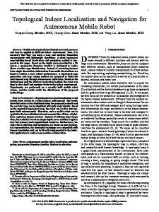
simulation environment, that is to say I focus on metric spatial properties of objects like distances, and coordinates. The developed robot has to build a cognitive map — “a view from above” — of small rooms while it visits every reachable location (Szabó, R. 2003). Fig. 1., Fig. 2. show some typical experimental area.
2. Previous work
Fig. 1. Radial maze
My former goal was to create a metric navigation module for a modified Khepera robot in the Webots
In this experiment I modified the selected Khepera robot. The 8 infra-red distance sensors were changed to 24
201
sonars with a sensing range of 15 cm to facilitate the perception of the environment.
occupancy grid values is possible, sonar scans can be “concatenated” to previous experiences. After the local grid is created around the robot its values have to be merged into the global grid. Beyond the coordinate transformation between the grids we need a global position where the local grid can be integrated. Robot position estimation is not an immanent property of the occupancy grid technique so an accepted method is to use a position estimation method like odometry — continuous calculation of changes of the robot pose — combined with correction of errors accumulated by sensor and motor noise (Borenstein, J., 1995). Since my main focus is the occupancy grid the simulator provides the position to step across this problem. Fig. 3. shows the occupancy grid of a maze during the process of the exploration.
Fig. 2. AAAI contest maze The adopted method of metric navigation is based on the occupancy grid model pioneered by Moravec and Elfes (Moravec, H. P. & Elfes, A., 1985 and Elfes, A., 1989). This general structure in two dimension manages a tesselation of the plane in cells. Each cell of the occupancy grid contains a probability value which is an estimation that the represented position is occupied by some object. After the investigation of other probabilistic navigation possibilities like Kalman-filter or expectation maximization (Thrun, S., 2002), I have chosen this grid technique because it is relatively simple to implement and because of its iterative nature. The important steps of the map building, in accordance with Thrun's work (Thrun, S., 1998), are the following: • sensor interpretation • integration over time • pose estimation • global grid building • exploration
Fig. 3. Occupancy grid of a maze 2.2. Iterative evaluation After the robot is ready to create the environment map, a driving force is needed to urge the robot to explore all the reachable places, otherwise it would wander randomly. For this reason we implemented a variant of value iteration. This method is well-known in the domain of reinforcement learning (Sutton, R. & Barto, A., 1998).
2.1. Occupancy grid creation The sensor interpretation is the first phase in the creation of the occupancy grid based navigation. During this process the 24 sonar scalar values are converted to local occupancy values around the robot. The conditional probabilities of grid cells are determined by a predefined conversion function: probabilities are high at the point of a measurement, and are low closer to the robot. Since different sonar measurements give different values for a grid cell because of noise and changing viewpoint, it is important to integrate the conditional probabilites of distinct moments. Using the assumption of the indepence of measurements — that generally does not hold — and the Bayes theorem, incremental calculation of
202
Fig. 4. Cost matrix of the maze
The selected algorithm helps to find the minimum costpath to unexplored regions of the occupancy grid. A cost matrix is calculated iteratively and after convergence for every occupancy grid cell the cost of travelling to an unexplored grid cell from the actual cell is given (Fig. 4). Exploration direction is then a resultant of the cost matrix, the actual direction of the robot, and an obstacleavoidance behaviour. 3. Building a topological graph from occupancy grid Exploration using value iteration is a very timeconsuming task. Values of the cells of the cost matrix are calculated by a process which scans through the whole matrix many times. Furthermore the next exploration direction is based on this gradient map and it does not take into account the constraint of the robot dynamism, sometimes resulting a fairly clumsy movement. Accordingly it seems a natural improvement to replace the value iteration module with a topological graph. This graph emphasizes the links between landmarks, the possibility to move from one place to another. Edges represent traversable corridors of the environment and nodes are the crossings or end points. Navigation using the graph is much faster since its size is some order of magnitude smaller than of the cost matrix. Chapter 2 of my book (Szabó, R. 2001) compares metric and topological navigation in detail. There are many different ways of creating a navigation graph using a metric map. Skeletonization, Voronoidiagrams, matching opposite contours, sparse pixel approaches are among the possibilities (Thrun, S., 1998 and Tombre, K. & Ah-Soon, C. & Dosch, P. & Masini, G. & Tabbone, S., 2000). In any case, the occupancy grid can be viewed as a two-dimensional greyscale image of the environment, hence digital image processing methods are valid approaches (Elfes, A. 1989). Since I selected skeletonization, steps of topological navigation using the occupancy grid are the following: • • • •
skeletonization chaining the skeleton to form edges graph optimization navigation using the graph
3.1. Skeletonization I decided to produce the skeleton of the explored and unoccupied region of the environment. At the end of the process skeleton points are those places where the robot is hopefully not blocked by any obstacles. For this reason I utilized medial axis transform (MAT) (Borgefors, G., 1986). An interior point of the shape belongs to the medial axis if this point lies at the same distance from two or more nearest contour points. Unfortunately one drawback of MAT appeared during my tests: medial axis of discrete objects and shapes — like the discrete occupancy grid to be projected — may
be disconnected. This deficiency is not acceptable in our case since the resulting skeleton has to contain all connected routes among landmarks of the environment. As a second attempt instead of using medial axis transform I applied a thinning algorithm to “peel the union”, in other words I iteratively shrinked the object to its one pixel wide skeleton (Jain, A. K., 1989). During this process the border pixels are deleted successively while topology and morphology of the object is preserved, that is to say no pixels are deleted at the end of a line or at the connection of two regions. The thinning algorithm works as it is described in Algorithm 1. Labeling of pixels around the actual pixel (P1) advances counter-clockwise. Z0(P1) - the number of zero to nonzero translations in the sequence P2, P3, P4, P5, P6, P7, P8, P9, P2 NZ(P1) - the number of nonzero neighbours of P1 Steps: 1. Scan through all the points of the image. 2. Calculate Z0(P1), NZ(P1), Z0(P2), Z0(P4), for all points. 3. Delete P1 if the conditions simultaneously satisfied: 2