Journal of
Marine Science and Engineering Article
Towards the Development of an Operational Forecast System for the Florida Coast Vladimir A. Paramygin, Y. Peter Sheng * and Justin R. Davis Coastal and Oceanographic Engineering Program, University of Florida, Gainesville, FL 32611-6580, USA;
[email protected] (V.A.P.);
[email protected] (J.R.D.) * Correspondence:
[email protected]; Tel.: +1-352-294-7764 Academic Editor: Richard P. Signell Received: 18 July 2016; Accepted: 5 January 2017; Published: 13 January 2017
Abstract: A nowcasting and forecasting system for storm surge, inundation, waves, and baroclinic flow for the Florida coast has been developed. The system is based on dynamically coupled CH3D and SWAN models and can use a variety of modules to provide different input forcing, boundary and initial conditions. The system is completely automated and operates unattended at pre-scheduled intervals as well as in event-triggered mode in response to Atlantic-basin tropical cyclone advisories issued by the National Hurricane Center. The system provides up to 72-h forecasts forward depending on the input dataset duration. Spatially, the system spans the entire Florida coastline by employing four high-resolution domains with resolutions as fine as 10–30 m in the near-shore and overland to allow the system to resolve fine estuarine details such as in the Intracoastal Waterway and minor tributaries. The system has been validated in both hindcast and nowcast/forecast modes using water level and salinity data from a variety of sources and has been found to run robustly during the test periods. Low level products (e.g., raw output datasets) are disseminated using THREDDS while a custom defined web-based graphical user interface (GUI) was developed for high level access. Keywords: forecasting; storm surge; baroclinic; Florida
1. Introduction Coastal zones in the U.S. and throughout the world are subject to increasing hazards including storms and storm surge, sea level rise, and harmful algal bloom. Tropical cyclones and associated surge and inundation along the southeastern US coastline area major concern for coastal communities and their economies. Coastal waters in the southeastern US support ecologically and economically significant ecosystems, providing tourism, boating, fishing, and other recreational opportunities with an annual economic benefit of $675+ billion. With 73.5% of the population living in the coastal zone and 77.1% of GDP coming from shore-adjacent counties, this concern about tropical cyclones is particularly important to the State of Florida as it ranks in the top five of US states in the total ocean economy for its reliance on coastal tourism, recreation, and transportation sectors for employment [1,2]. Florida’s battle with tropical cyclones is notorious as it has been affected by more hurricanes than any other state. For example, between 1900 and 2010, Monroe County, located along the southwest Florida coast was affected by 32 hurricanes, which is more than any other county in the United States [3]. Management of the Floridian coastal environment is a challenging task for several state and local agencies including Florida Department of Environment Protection, Florida Division of Emergency Management, Water Management Districts, and coastal counties as well as local governments. The work of these agencies is heavily dependent on information made available by such federal agencies as National Oceanic and Atmospheric Administration (NOAA), Federal Emergency Management Agency (FEMA), U. S. Geological Survey (USGS), etc. Within NOAA (the primary agency associated with surge and inundation hazards), the National Weather Service (NWS), National Ocean Service (NOS), J. Mar. Sci. Eng. 2017, 5, 8; doi:10.3390/jmse5010008
www.mdpi.com/journal/jmse
J. Mar. Sci. Eng. 2017, 5, 8
2 of 22
as well as the U.S. Integrated Ocean Observing System (IOOS) provide a multitude of data on the national scale. However, data at physical scales relevant to regional and sub-regional management can be scarce, which makes coastal zone management difficult. There are several operational and/or quasi-operational forecasting systems for the Florida coast. The National Hurricane Center (NHC) provides the official tropical cyclone surge forecasts, based on the SLOSH [4] and ADCIRC [5] model forecasts. These forecasts provide information for emergency operations and evacuation along the U.S. Atlantic and Gulf coasts. However, both SLOSH and ADCIRC forecasts are based on two-dimensional barotropic models. SLOSH is further constrained in that it uses a coarse grid resolution (on the order of a kilometer) and lacks such important processes as tides, waves, and nonlinear inertia. The Center for Ocean Atmospheric Prediction Studies (COAPS) of Florida State University operates a HYCOM-based 3D forecasting system [6] which possesses robust physics (such as atmospheric-ocean interaction) and 3D baroclinic ocean processes. However, the HYCOM forecasting system uses a relatively coarse grid (>500 m) which is inadequate to resolve the complex coastal and estuarine processes. Similar issues can be found in other Florida forecasting systems based on implementations of the ROMS model [7] and the NCOM model [8] which use relatively course grid resolutions along the Florida coast. To address the need for a high-resolution forecasting system which can simulate water levels, waves, salinity, and baroclinic circulation along the Florida coast the Advanced Coastal Modeling System (ACMS) was developed. This system can provide forecast information which could be used by the state and local agencies to enhance management of coastal ecosystems and coastal communities in the state of Florida. Example applications of ACMS forecast information include improved protection of coastal communities from coastal inundation; improved coastal and marine planning and decision-making; improved public health advisories; improved storm surge and rip current warnings; safer and more efficient marine operations and emergency response; advanced decision-making regarding commercial, recreational fisheries and shoreline erosion; improved planning to enhance climate resiliency; improved operational management of water control structures and utility infrastructure by Water Management Districts and utility companies, respectively; and improved emergency operations and management during tropical cyclones via information provided to Weather Forecasting Offices (WFOs) and National Estuarine Research Reserves. The ACMS is based on the dynamically-coupled CH3D [9–13] and SWAN [14] models which account for wave effects (such as wave-induced wind stresses, wave-current interaction which includes radiation stresses throughout the water column and wave-current bottom stresses) and can incorporate a variety of input forcing functions and boundary and initial conditions for driving these models. The system is automated and can be run at pre-scheduled intervals or be triggered by such events as tropical storm advisories by the National Hurricane Center. Another significant issue to be considered for operational modeling is computational efficiency. Multiple (often over ten) forecasting model runs with high grid resolutions every day require significant computing resources. A forecasting system must be able to produce timely forecasts, since the value of forecast products declines quickly with the time it takes to produce them. In the remainder of this paper, ACMS is first described, followed by a description of the model setup, and example model validations. 2. Materials and Methods 2.1. The ACMS Modeling System 2.1.1. CH3D CH3D (Curvilinear Hydrodynamics in 3D) is a hydrodynamic model originally developed by Sheng [9,10]. The model can simulate 2-D and 3-D barotropic and baroclinic circulation driven by tide, wind, density gradients, and waves. CH3D uses a boundary-fitted non-orthogonal curvilinear grid
J. Mar. Sci. Eng. 2017, 5, 8
3 of 22
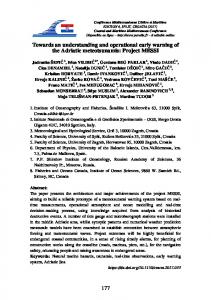
in the horizontal direction and a terrain-following sigma grid in the vertical direction. As such, the model can accurately represent complex shoreline and geometries in coastal regions. It uses a robust turbulence closure model to represent vertical turbulent mixing [15] and a Smagorinsky type model for horizontal turbulent mixing. The model uses bathymetry and topography which are referenced to the NAVD88 vertical datum for all domains to accurately simulate the coastal inundation. CH3D has been applied to such water bodies as Charlotte Harbor, Biscayne Bay, Apalachicola Bay, Florida Bay, Indian River Lagoon, Lake Okeechobee, Lake Apopka, Sarasota Bay, St. Johns River, Tampa Bay, Naples Bay, and Rookery Bay in Florida, as well as Chesapeake Bay, New York Bight, Long Island Sound, and the Gulf of Mexico. 2.1.2. CH3D-IMS CH3D has been coupled to models of wave, sediment transport, water quality, light attenuation, and sea grass dynamics to produce CH3D-IMS [16], an Integrated Modeling System for simulating the response of estuarine and coastal ecosystems to anthropogenic (e.g., increased nutrient loading) and natural (e.g., sea level rise) changes. 2.1.3. CH3D-SSMS CH3D-SSMS (Storm Surge Modeling System) is a modeling suite that features coupled CH3D and SWAN models for coastal dynamics and large scale surge-wave models that are used to extract boundary conditions for the coastal model [11,17], which has been used extensively to simulate storm surge and inundation due to various tropical cyclones including Hurricanes Charley (2004), Dennis (2005), Isabel (2003), Frances (2004), Ivan (2004), Jeanne (2004), Katrina (2005), Wilma (2005), Katrina (2005), Ike (2009), Sandy (2012), Matthew (2016), and others [11–13,17–19]. Details of the CH3D model, including equations of motion and boundary and initial conditions, are described in [11]. CH3D-SSMS contains a robust flooding and drying scheme which is an extension of that developed by Davis and Sheng [20]. In a regional storm surge and coastal inundation model Testbed [21], CH3D-SSMS was compared with ADCIRC [5], CMEPS [22], FVCOM [23], and SLOSH [4]. Detailed comparisons of models were made in terms of simulated storm surges during historic storms as well as coastal inundation maps including the surge atlas and the 1% annual chance coastal inundation maps which is also known as the Base Flood Elevation (BFE) according to the Federal Emergency Management Agency (FEMA) of the US [24]. The results of CH3D-SSMS were found to compare well with observed water level data and was as accurate as other models. The computational efficiency of CH3D-SSMS is only inferior to the extremely efficient SLOSH model which uses a very coarse grid (~1 km) and has simpler physics. The model Testbed results demonstrated that, to obtain accurate model results efficiently, it is feasible to use a highly efficient coastal surge-wave model, e.g., CH3D-SWAN, with high resolution in the coastal region, and couple it to large-scale surge-wave models with coarser resolution in the offshore region. Alternatively, one can use an unstructured grid surge-wave model for the coastal and offshore domains with a single grid, but a high-resolution grid in the coastal region often results in stringent computational time step limitation and requires dramatically more computational resources. CH3D suites continue to be improved as new research enables incorporation of more dynamic features, e.g., vegetation effects on storm surge, into the models. For example, Lapetina and Sheng [25] recently used the vegetation-resolving ACMS to simulate the effects of vegetation, three-dimensionality, and onshore sediment transport on complex storm surge dynamics during Hurricane Ike which inflicted major damage to the Texas coast in 2009. Results of the 3D model are found to be more accurate than 2D model results. 2.2. ACMS The cornerstone of the ACMS modeling system includes the CH3D (shallow water hydrodynamics) and SWAN (wave) models, running on four domains (Figure 1) that span the entire Florida coast.
J. Mar. Sci. Eng. 2017, 5, 8
4 of 22
2.2. ACMS J. Mar. Sci. Eng. 2017, 5, 8
4 of 22
The cornerstone of the ACMS modeling system includes the CH3D (shallow water hydrodynamics) and SWAN (wave) models, running on four domains (Figure 1) that span the entire The twocoast. models aretwo dynamically coupled, whichcoupled, enables representation complex physics such as Florida The models are dynamically which enablesof representation of complex vertically varying wave-current interaction. ACMS is essentially the integration of CH3D-SSMS and physics such as vertically varying wave-current interaction. ACMS is essentially the integration of CH3D-IMS which was described in the section. CH3D-SSMS and CH3D-IMS which wasprevious described in the previous section.
Figure 1. 1. Advanced (ACMS) Florida Florida coast coast domains: domains: Northern Northern Gulf Gulf (NG) (NG) of of Figure Advanced Coastal Coastal Modeling Modeling System System (ACMS) Mexico (pink), Southwest (SW) (blue), Southeast (SE) (green), and East Coast (EC) (yellow). Mexico (pink), Southwest (SW) (blue), Southeast (SE) (green), and East Coast (EC) (yellow).
SWAN is a third-generation phase-averaged wave model that can be applied to nearshore wave SWAN is a third-generation phase-averaged wave model that can be applied to nearshore wave modeling. The model can use a variety of computational grid arrangements including nonmodeling. The model can use a variety of computational grid arrangements including non-orthogonal orthogonal regular, curvilinear, and unstructured triangular grids. SWAN accounts for wave regular, curvilinear, and unstructured triangular grids. SWAN accounts for wave propagation in propagation in time and space, shoaling, refraction due to currents and depth, frequency shifting due time and space, shoaling, refraction due to currents and depth, frequency shifting due to currents to currents and dynamic depth, wave generation by wind, energy dissipation by bottom friction, and dynamic depth, wave generation by wind, energy dissipation by bottom friction, depth-induced depth-induced breaking and transmission through and reflection from obstacles (full or partial breaking and transmission through and reflection from obstacles (full or partial reflection can be reflection can be considered). SWAN represents waves using a two-dimensional wave action density considered). SWAN represents waves using a two-dimensional wave action density energy spectrum energy spectrum and the evolution of the spectrum is described by the spectral action balance and the evolution of the spectrum is described by the spectral action balance equation in which a equation in which a local rate of change of action density in time is related to the propagation of local rate of change of action density in time is related to the propagation of action in geographical action in geographical space, shifting of relative frequency due to currents and depths, depth-induced space, shifting of relative frequency due to currents and depths, depth-induced and current-induced and current-induced refraction balanced by the source term in terms of energy density representing refraction balanced by the source term in terms of energy density representing the effects of energy the effects of energy generation, energy dissipation and nonlinear wave-wave interactions. generation, energy dissipation and nonlinear wave-wave interactions. ACMS can use a variety of wind fields such as ACMS can use a variety of wind fields such as • Hurricane Research Division’s H*Wind [26]; • Hurricane Research Division’s H*Wind [26]; Navy’s NOGAPS [27]; • Navy’s NOGAPS [27]; GFDL [28]; NAM (North • GFDL [28]; American Mesoscale) that uses WRF (Weather Research and Forecasting model [29]) and is run by the National Centers for Environmental Prediction [30]; and • NAM (North American Mesoscale) that uses WRF (Weather Research and Forecasting model [29]) and is run by the National Centers for Environmental Prediction [30]; and
J. Mar. Sci. Eng. 2017, 5, 8
5 of 22
J. Mar. Sci. Eng. 2017, 5, 8
5 of 22
• • Several synthetic by storm stormparameters parametersthat thatare arederived derived from Several syntheticparametric parametricwind wind models models driven driven by from National Hurricane Center (NHC) predictions. National Hurricane Center (NHC) predictions. 2.3.2.3. ACMS Modules ACMS Modulesand andWorkflow Workflow ACMS consists 2): (1) (1)data dataacquisition acquisitionand and pre-processing module; ACMS consistsofoffour fourmain mainmodules modules (Figure 2): pre-processing module; (2)(2) simulation setup (staging/running/etc.) and job management module; (3) post-processing module; simulation setup (staging/running/etc.) and job management module; (3) post-processing module; and visualizationmodule. module.These These modules modules provide asas input data and (4)(4) visualization provide automation automationofofsuch suchprocesses processes input data acquisition, archiving and cataloging of data model results, pre-processing, setting up acquisition, archiving and cataloging of data andand model results, datadata pre-processing, setting up model model simulations, running and monitoring jobs, post-processing of results, model results, and visualization. simulations, running and monitoring jobs, post-processing of model and visualization. Some of Some of the most important properties of the ACMS are full automation, compliance with existing the most important properties of the ACMS are full automation, compliance with existing standards forand ocean data, efficient computational use of available computational Previous forstandards ocean data, efficient useand of available resources. Previous resources. implementation of the implementation of the system showed that it can perform both 3D baroclinic and storm surge system showed that it can perform both 3D baroclinic and storm surge simulations simultaneously simulations during tropical cyclones [18], asof well as ensemble forecasting of storm of during tropicalsimultaneously cyclones [18], as well as ensemble forecasting storm surges based on an ensemble surges based on an ensemble of storm tracks generated from the probability distribution of previous storm tracks generated from the probability distribution of previous track forecasting errors [31]. track forecasting errors [31]. The data acquisition module is responsible for data acquisition and consists of monitors that The data acquisition module is responsible for data acquisition and consists of monitors that poll poll the data providers for new data and acquires the data as it becomes available. Monitors for the data providers for new data and acquires the data as it becomes available. Monitors for a variety a variety of datasets are available: NOAA NHC advisories, the U.S. Navy’s Automated Tropical of datasets are available: NOAA NHC advisories, the U.S. Navy’s Automated Tropical Cyclone Cyclone Forecasting System (ATCF [32]) forecast products, atmospheric inputs (NAM, NOGAPS, Forecasting System (ATCF [32]) forecast products, atmospheric inputs (NAM, NOGAPS, GFDL, etc.), GFDL, etc.), and boundary and initialfor conditions forfrom circulation from as such models[33] as and HYCOM [33] and boundary initial conditions circulation such models HYCOM ROMS, and ROMS, and and boundary and initialfor conditions forwave waves from such waveasmodels such III as (WWIII) WaveWatch boundary initial conditions waves from models WaveWatch [34]. III (WWIII) [34]. River flow measurements and predictions, salinity measurements, etc. are also collected River flow measurements and predictions, salinity measurements, etc. are also collected where where available USGS, National Estuarine Research Reserves, the National Service available fromfrom USGS, National Estuarine Research Reserves, and theand National WeatherWeather Service River River Forecast Center. data obtained theybecome becomeavailable, available, processed (withQA/QC, QA/QC, Forecast Center. All All the the data areare obtained as as they processed (with subsetting, and necessary and cataloged cataloged(using (usingaaMySQL MySQLdatabase). database). subsetting, and necessaryformat formatconversions), conversions), archived, archived, and
Figure 2. ACMS workflow diagram. Figure 2. ACMS workflow diagram.
ACMS supports two modes of operation: ACMS supports two modes of operation: Event triggered, where a model instance is created as a response to an event (such as an NHCissued tropical cyclone Event triggered, whereadvisory) a modelorinstance is created as a response to an event (such as an NHC-issued tropical cyclone advisory) or
J. Mar. Sci. Eng. 2017, 5, 8
-
J. Mar. Sci. Eng. 2017, 5, 8
6 of 22 6 of 22
Preset cycles, where a model is initiated at fixed times, which usually follow the standard 4-cycles per day scheme (modela initialized at 00:00,at06:00, 18:00 UTC).follow the standard 4 Preset cycles, where model is initiated fixed 12:00 times,and which usually cycles per day scheme (model initialized at 00:00, 06:00, 12:00 and 18:00 UTC). The job management module initiates the simulation and polls the data acquisition module. The management module initiates simulation polls the data acquisition module. Once all thejob data necessary for model input the is collected, theand module generates the necessary input Once all the data necessary for model input is collected, the module generates the necessary input files, sends the job to the computing cluster via HTCondor job management system [35] and monitors to the computing cluster via HTCondor job management system [35] and monitors thefiles, job sends statusthe forjob potential computing resource failures in which case the jobs are resubmitted to the job status for potential computing resource failures in which case the jobs are resubmitted to alternate resources. alternate resources. The post-processing module extracts output from completed forecast runs, generates aggregate The post-processing module extracts output from completed forecast runs, generates aggregate products, calculates statistics, and places products and outputs in the archive. ACMS currently uses products, calculates statistics, and places products and outputs in the archive. ACMS currently uses NetCDF with CF-1.5 conventions as a data format of choice and Unidata’s THREDDS Data Server [36] NetCDF with CF-1.5 conventions as a data format of choice and Unidata’s THREDDS Data Server as [36] the main for data distribution. Visualization module (mostly client-based) as theplatform main platform for data distribution. Visualization module (mostly client-based)isiswritten written in JavaScript and uses THREDDS server (via(via WMS feeds and NetCDF in JavaScript and uses THREDDS server WMS feeds and NetCDFsubsetting) subsetting)asasaadata dataprovider provider to display data in a user-friendly manner (Figure 3). to display data in a user-friendly manner (Figure 3).
Figure Sample ACMSweb-based web-basedinterface interface for for data data preview St.St. Johns Figure 3. 3. Sample ACMS preview and anddownload downloaddeveloped developedforfor Johns River Water Management District with focus on the Indian River Lagoon on the east coast of Florida. River Water Management District with focus on the Indian River Lagoon on the east coast of Florida.
Data availability is the limiting factor for initiating a new forecast cycle. A complete data set such the limiting factorthe for initiating a new forecast and cycle. complete as Data wind,availability the waves atisthe open boundary, surge at the open boundary, theA flow rates at data riversset such as wind, the waves at the open boundary, the surge at the open boundary, and the flow rates should be available from the archive for the forecast cycle to be initiated. Data is pulled from the at archive rivers should available from Module the archive forecast cyclefiles to be by thebe Data Processing and for all the necessary input areinitiated. generatedData for is allpulled the from the archive by the Data Processing Module and all necessary input files are generated for all the simulations that are scheduled to run within that cycle. Completion of this process triggers the start simulations that are Core scheduled to which run within that cycle. of this process triggers the start of the cycle at the Module is responsible forCompletion setting up the boundary conditions for all of the the models cycle atinvolved the CoreinModule which is responsible for setting the boundary for all the cycle, scheduling, and submitting theup simulation to one conditions of the available thecomputational models involved in theThere cycle,are scheduling, and submitting the simulation to some one of resources. mechanisms that enable forecasts even when ofthe the available data is missing. Certain data such as missing atmospheric or relatively in of time-series computational resources. There are mechanisms thatsnapshots enable forecasts evenshort whengaps some the data is data can be reconstructed, interpolated or extrapolated based on data. missing. Certain data such as missing atmospheric snapshots oravailable relatively short gaps in time-series data can be reconstructed, interpolated or extrapolated based on available data. 2.4. ACMS Model Setup 2.4. ACMS Model Setup Two implementations of ACMS are discussed in this paper:
of ACMS discussed in this paper: 1. Two 2Dimplementations implementation—The 2D are barotropic CH3D model is coupled with SWAN and CH3D receives open boundary conditions from a large-scale ADCIRC model running on a coarse grid
J. Mar. Sci. Eng. 2017, 5, 8
1.
2.
7 of 22
2D implementation—The 2D barotropic CH3D model is coupled with SWAN and CH3D receives open boundary conditions from a large-scale ADCIRC model running on a coarse grid ~2–5 km, while SWAN receives open boundary condition from WWIII. Despite the coarseness of the grid, ADCIRC produces satisfactory results along the offshore CH3D boundary and runs very quickly to allow syncing with the CH3D model. This implementation is event-triggered by NHC tropical cyclone advisories. ACMS downloads NHC advisories and, whenever it contains forecasted tropical cyclone track coming within 100 miles of a CH3D domain, creates a model instance for that advisory. This implementation is used to quickly forecast storm surge and inundation during tropical storms. Not only do 2D model simulations complete quicker, but all the inputs required for the model are also contained in the advisory, because the surge and wave models are driven by a synthetic parametric model for atmospheric wind and pressure. In most cases, the amount of time between the advisory time stamp and prediction is less than two hours. 3D Implementation—The 3D baroclinic CH3D model is coupled with SWAN, and CH3D receives boundary conditions from a large-scale HYCOM or ROMS model, while SWAN receives open boundary condition from WWIII. The model runs four times a day at 6-h intervals starting at 00:00 UTC. This implementation is intended to provide more comprehensive forecasts including water levels, waves, baroclinic circulation, and salinity. However, this increased fidelity comes at a cost: not only the model runtime increases to 4–6 h (depending on domain and conditions such as networking and transfer speeds, etc.), but the time required to fetch all the inputs (including open boundary conditions from HYCOM or ROMS, atmospheric predictions from NAM, and river flows, etc.) can be twice as long. The model has the capability to simulate temperature, however, due to limited data available for boundary conditions and verification, current forecasting implementation does not include temperature simulation.
2.4.1. Atmospheric Forcing Atmospheric forcing in ACMS includes atmospheric pressure, wind, and precipitation. The system can use a variety of wind fields as well as several synthetic parametric models. The 2D implementation uses the parametric model of Xie et al. [37]. Model parameters such as location of the storm, maximum wind, and radii to 34 kt, 50 kt, and 64 kt winds are based on the NHC predicted storm parameters. The 3D implementation is driven by the atmospheric forcing predicted by the NAM model. 2.4.2. Surge-Wave Coupling In ACMS, the CH3D model is dynamically coupled to the SWAN wave model [14]: wave results obtained by SWAN are passed to CH3D and water depths and currents obtained by CH3D are passed onto SWAN. This accounts for wave setup and wave-current interaction within the CH3D model, which features several formulations for calculating wave stresses [38], including vertically varying formulations (e.g., Mellor [39]) as well as the vertically uniform formulation of Longuet-Higgins and Stewart [40,41]. The 3D implementation of the model uses the formulation by Mellor [39] as it was found to produce more accurate results [38]. The time step used for CH3D simulation is 60 s and time step used for SWAN simulation is 5 min, which is when the two models exchange information. 2.4.3. Coastal-Offshore Coupling Both coastal CH3D and SWAN models use the same non-orthogonal curvilinear model grid and are dependent upon open boundary conditions provided by larger scale ocean models. ACMS interfaces enable it to receive boundary conditions from a variety of large-scale models such as HYCOM, ROMS, CH3D, and ADCIRC for CH3D, and larger-scale SWAN or WWIII for SWAN. In the 2D implementation, CH3D obtains open boundary conditions (elevation at the open boundary) from a coarse-grid (~2–5 km) ADCIRC model which is run simultaneously with the CH3D model. Large-scale SWAN model produces boundary conditions for the coastal SWAN model.
J. Mar. Sci. Eng. 2017, 5, 8
8 of 22
In the 3D implementation, CH3D obtains open boundary conditions (vertically varying currents and salinity) from a HYCOM, while SWAN derives its boundary conditions either from a WWIII model or a large-scale SWAN model. 2.4.4. ACMS Model Domains and Forecast Cycles The four domains used by ACMS span the entire Florida coastline (Figure 1) and extend 50–100 km offshore (Table 1). The forecasts range from 48 h up to 72 h, depending on the configuration and available input. Each cycle is initialized from the previous cycle, and a 6-h nowcasting is performed to fill the 6-h gap between cycles, followed by a forecast. ACMS model domains use NAVD88 as a vertical datum of choice, which makes computing surge, inundation, and flooding a simple and transparent process since all the topography data is generally referenced to NAVD88. The 3D implementation of the model typically uses six equally spaced sigma layers in vertical—this number was determined by comparing simulations obtained with 4, 6, 8, 16 layers, which found that 6 layers were sufficient to resolve the pycnocline and that going from 6 to 8+ layers provides negligible differences in simulation results. Table 1. Characteristics of Advanced Coastal Modeling System (ACMS) model domains. Domain
Minimum Resolution (m)
Approximate Grid Cell Count
Average Offshore Extent (km)
East Coast (EC) Southeast (SE) Southwest (SW) Northern Gulf of Mexico (NG)
32 21 29 47
339,000 607,000 366,000 404,000
55 60 65 75
2.4.5. Boundary Conditions The water level at the open boundary of CH3D domain is prescribed by combining the water level predicted by a regional ocean circulation model and spatially varying tidal constituents which include M2, S2, N2, K2, K1, O1, P1, Q1, SA, and SSA. These tidal constituents were determined to be important for the Florida coast based on the NOAA tidal gauge data, while other constituents generally are estimated to have an amplitude of less than 1 cm. The constituents at the open boundary are developed via an iterative process in which phases and amplitudes at the open boundary are adjusted during tide-only simulations to provide the best possible fit with observed tides at the coastal stations. Salinity at the open ocean boundary is interpolated from a 1/12 degree HYCOM or ROMS (provided at 6-h intervals). Open boundary conditions for SWAN are wave height and period obtained from the results of a 0.25 degree WWIII model. River flow measurements/forecasts and salinity measurements are gathered from a variety of sources such as NOAA Advanced Hydrologic Prediction Service, Florida DEP, Florida Water Management Districts, and National Estuarine Research Reserves. These data serve as boundary conditions for flow and salinity upstream of rivers and creeks and are crucial to accurate predictions of currents and salinity in estuaries, inlets, and near-shore zone. River flow and salinity data used for boundary conditions in estuaries are extrapolated in time based on the trend identified in previous data for stations where flow forecasts are unavailable or the forecasted period is shorter than the length of ACMS forecast. The extrapolation is based on identifying a linear trend during the last 7 days and using it to extrapolate the flow (subject to a maximum increase/decrease of 2 ppt in a 7-day period). This was found to produce slightly better results compared to using the last available value for the entire forecast period.
J. Mar. Sci. Eng. 2017, 5, 8
9 of 22
J. Mar. Sci. Eng. 2017, 5, 8 3. Results
9 of 22
3. Results 3.1. Model Validation 3.1. Model Using theValidation model setup described in the previous section, a series of validation tests were performed by hindcasting non-storm events (lighter wind speeds, tidally-dominated flow) as well Using the model setup described in the previous section, a series of validation tests were as several tropical cyclones including Andrew (1992), Jeanne (2004), Wilma (2005), and Fay (2008). performed by hindcasting non-storm events (lighter wind speeds, tidally-dominated flow) as well as The storms selected to represent hurricanes from (2005), slow moving Storm several are tropical cyclones including different Andrew (1992), Jeanneranging (2004), Wilma and Fay Tropical (2008). The stormsbecame are selected to represent different hurricanes ranging from slow moving Tropical Storm Fay, Fay, which almost stationary for about a day just off the east coast of Florida near Jacksonville, which became almostWilma stationary about a daythe justentire off thestate east coast of than Florida Jacksonville, to to fast-paced Hurricane thatfor went across in less sixnear hours with significant fast-paced Hurricane Wilma that went across the entire state in less than six hours with significant variation in intensity and size. Some forecast results are also presented since the ACMS system has variation in intensity and size. Some forecast results are also presented since the ACMS system has been running in the quasi-operational mode since 2012. Only a select few stations (Figure 4) per been running in the quasi-operational mode since 2012. Only a select few stations (Figure 4) per domain are shown here as it would be impossible to show model-data comparisons for all of them in domain are shown here as it would be impossible to show model-data comparisons for all of them in the scope of this paper. the scope of this paper.
Figure 4. Location of select data stations used for ACMS validation.
Figure 4. Location of select data stations used for ACMS validation.
3.1.1. Non-Storm Conditions
3.1.1. Non-Storm Conditions
Simulation of tides is a key feature of a forecasting system because water levels and currents are
very important safeisnavigation and recreation as well assystem the increasing coastal inundation during Simulation of for tides a key feature of a forecasting because water levels and currents highimportant tides. Under weather conditions, tides usually dominate and determine the inundation coastal are very forcalmer safe navigation and recreation as well as the increasing coastal circulation. Hence, thecalmer ability to accurately predict tidal water leveldominate and flows and is crucial. Data during during high tides. Under weather conditions, tides usually determine the coastal 2008–2014 were used for validation purposes and the criterium for tidal validation is to achieve an circulation. Hence, the ability to accurately predict tidal water level and flows is crucial. Data during average RMS error of 7 cm per domain. The total number of stations used for validation of tides is: 2008–2014 were used for validation purposes and the criterium for tidal validation is to achieve an nine for the EC domain, five for the SE domain, five for the SW and six for the NG domains. Vilano average RMS error of 7 cm per domain. The total number of stations used for validation of tides is: nine Beach (Figure 5) and Melbourne (Figure 6) stations are examples of tidal simulations on the EC for the EC domain, five for the SE domain, five for the SW and six for the NG domains. Vilano Beach (Figure 5) and Melbourne (Figure 6) stations are examples of tidal simulations on the EC domain.
J. Mar. Sci. Eng. 2017, 5, 8
10 of 22
J. Mar. Sci. Eng. 2017, 5, 8 10 of 22 J. Mar. Sci. Eng. 2017, 5, 8 10 of 22 Data domain. a NOAA station at Naples, (Figure FL 7) on the west wascoast usedwas to validate the tides J.from Mar. Sci. Eng. 5, 8a NOAA 10 of 22 Data2017, from stationFL at Naples, (Figure 7) oncoast the west used to validate
for
the SW domain. from NOAA station at Naples, FL (Figure 7) on the west coast was used to validate thedomain. tides Data for the SW adomain.
domain. from NOAA station at Naples, FL (Figure 7) on the west coast was used to validate the tides Data for the SW adomain. the tides for the SW domain.
Figure 5. Comparison of simulated(hindcast) (hindcast) and and observed levels at Vilano Beach station for for Figure 5. Comparison of simulated observedwater water levels at Vilano Beach station Figure 5. Comparison tidally-dominated flow.of simulated (hindcast) and observed water levels at Vilano Beach station for tidally-dominated flow. of simulated (hindcast) and observed water levels at Vilano Beach station for Figure 5. Comparison tidally-dominated flow. tidally-dominated flow.
Figure 6. Comparison of simulated (hindcast) and observed water levels at Melbourne station for Figure 6. Comparison simulated(hindcast) (hindcast) and and observed levels at Melbourne station for for tidally-dominated flow. Figure 6. Comparison of of simulated observedwater water levels at Melbourne station Figure 6. Comparison tidally-dominated flow.of simulated (hindcast) and observed water levels at Melbourne station for tidally-dominated flow. tidally-dominated flow.
Figure 7. Comparison of simulated (hindcast) and observed water levels at Naples station for tidallyFigure 7. Comparison of simulated (hindcast) and observed water levels at Naples station for tidallydominated flow. Figure 7. Comparison of simulated and and observed water levels Naplesat station for tidallydominated flow. Figure 7. Comparison of simulated(hindcast) (hindcast) observed wateratlevels Naples station for flow. Tidaldominated Simulation
tidally-dominated flow. Tidal Simulation ACMS predicted amplitudes and phases of select tidal constituents (M2, S2, N2, K2, K1, TidalOverall, Simulation Overall, ACMS predicted amplitudes of select (M2, N2, K2,RMS K1, P1, Q1, SA, and SSA) are very close toand the phases observed valuestidal at allconstituents stations with theS2, average TidalO1, Simulation Overall, ACMS predicted amplitudes phases of values select tidal (M2, N2, K2,RMS K1, O1, Q1, under SA, and SSA) are very close to and the observed at allconstituents stations with theS2, average errorP1, being 5%. Overall, ACMS predicted ofvalues select at tidal constituents (M2, S2, N2, K2, K1, O1, P1, Q1, SA, and SSA) areamplitudes very close toand the phases observed all stations with the average RMS error being under 5%. error being 5%. are very close to the observed values at all stations with the average RMS O1, P1, Q1, SA, under and SSA)
error being under 5%.
J. Mar. Sci. Eng. 2017, 5, 8
J. Mar. Sci. Eng. 2017, 5, 8 Nuisance Flooding
11 of 22
11 of 22
Nuisance The ACMSFlooding was used to forecast “king” tides (astronomically high tides) near Miami Beach (FigureJ.8), and the results weretoprovided to the city Miami Beach.high During “king” tide, numerous Mar.The Sci. Eng. 2017, 5, 8 used 11 of 22 ACMS was forecast “king” tidesof (astronomically tides)anear Miami Beach South Florida communities Beach,toFort Lauderdale, Key West, Naples, etc.) experience (Figure 8), and the results(Miami were provided the city of Miami Beach. Duringand a “king” tide, numerous Nuisance Flooding South Florida communities Beach,ofFort KeyNuisance West, and Naples, etc.) nuisance flooding with streets(Miami inundated 30 Lauderdale, cm or more. flooding is experience occurring more nuisance flooding with streets inundated of cm some or more. Nuisance flooding is occurring more frequently as sea level continues to rise. By302050 communities (e.g., near Key West) expected Thethe ACMS was used to forecast “king” tides (astronomically high tides) Miami are Beach frequently as the sea level were continues to rise. By 2050 some communities (e.g.,aKey West) arenumerous expected (Figure 8), and the results provided to the city of Miami Beach. During “king” tide, to have nuisance flooding during more than 100 days per year. The City of Miami Beach installed to haveFlorida nuisance flooding during more thanFort 100 Lauderdale, days per year. The Cityand of Miami Beach 20 South (Miami Beach, West, Naples, etc.)installed experience 20 pumps in 2015 tocommunities mitigate nuisance flooding during kingKey tides. pumps in 2015 to mitigate nuisance flooding during king tides. nuisance flooding with streets inundated of 30 cm or more. Nuisance flooding is occurring more frequently as the sea level continues to rise. By 2050 some communities (e.g., Key West) are expected to have nuisance flooding during more than 100 days per year. The City of Miami Beach installed 20 pumps in 2015 to mitigate nuisance flooding during king tides.
8. Forecast of “king” tides and comparison with National Oceanic and Atmospheric Figure Figure 8. Forecast of “king” tides and comparison with National Oceanic and Atmospheric Administration (NOAA) observed and predicted water levels at Virginia Key station in October 2014 Administration (NOAA) observed and predicted water levels at Virginia Key station in October (initialization time: 6 October, 2014 00:00Z). 2014 (initialization time: 6 October, 2014 00:00Z). Figure 8. Forecast of “king” tides and comparison with National Oceanic and Atmospheric Administration (NOAA) observed and predicted water levels at Virginia Key station in October 2014 Simulation (initialization time:data 6 October, 2014 00:00Z). Limited salinity was available for validation with just two stations for the EC and SE
Salinity Simulation
Salinity
domains, five stations clustered inside Naples/Rookery Baytwo region on thefor west of Florida Limited salinity data was available forthe validation with just stations thecoast EC and SE domains, Salinity Simulation and a few in the Apalachicola Bay maintained by the Apalachicola National Estuarine Research five stations clustered inside the Naples/Rookery Bay region on the west coast of Florida and a few in Reserve (ANERR). Thedata quality salinity predictions canwith vary just drastically depending on EC availability Limited salinity wasofavailable for validation two stations for the and SE the Apalachicola Bay maintained by the Apalachicola National Estuarine Research Reserve (ANERR). and accuracy of river flow predictions. However, most stations show satisfactory agreement. The domains, five stations clustered inside the Naples/Rookery Bay region on the west coast of Florida The quality of salinity predictions can vary drastically depending on availability and accuracy of RMS domain during September and October 2014 varied between 2 ppt and 7 ppt and aerror few in in the the SW Apalachicola Bay maintained by the Apalachicola National Estuarine Research 2 river flow predictions. However, most stations show satisfactory agreement. The error in the with a correlation (r )of between 0.52 and 0.9. can The NG domain comparisons (Figure 9) show Reserve (ANERR).coefficient The quality salinity predictions vary drastically depending on RMS availability slightly better agreement with the October RMS error between 2 ppt and 5 ppt. RMS for stations in SW domain during and 2014 varied between 2 The ppt anderrors 7 ppt with a correlation and accuracy ofSeptember river flow predictions. However, most stations show satisfactory agreement. The the EC domain vary between 3 ppt and 9 ppt, most likely due to the inaccuracy and limited 2 RMS(r error in the SW0.52 domain September and October 2014 varied between ppt and 7 ppt better coefficient ) between and during 0.9. The NG domain comparisons (Figure 9) 2show slightly availability of rivercoefficient flow data(rthat provides fresh water inflow into the model domains. 2) between with a correlation 0.52 and 0.9. The NG domain comparisons (Figure 9) show agreement with the RMS error between 2 ppt and 5 ppt. The RMS errors for stations in the EC domain slightly better agreement with the RMS error between 2 ppt and 5 ppt. The RMS errors for stations in vary between 3 ppt and 9 ppt, most likely due to the inaccuracy and limited availability of river flow the EC domain vary between 3 ppt and 9 ppt, most likely due to the inaccuracy and limited data that provides fresh water inflow into the model domains. availability of river flow data that provides fresh water inflow into the model domains.
Figure 9. Comparison of simulated and observed salinity Cat Point station (NG domain), orange vertical lines indicate land fall times of the three storms: Frances, Ivan, and Jeanne. 9. Comparison of simulatedand andobserved observed salinity Point station (NG (NG domain), orange orange Figure Figure 9. Comparison of simulated salinityCat Cat Point station domain), vertical lines indicate land fall times of the three storms: Frances, Ivan, and Jeanne. vertical lines indicate land fall times of the three storms: Frances, Ivan, and Jeanne.
J. Mar. Sci. Eng. 2017, 5, 8
12 of 22
J. Mar. Sci. Eng. 2017, 5, 8
12 of 22
Surface Surface Current Current Simulation Simulation There There exist exist limited limited datasets datasets of of observed observed surface surface currents currents collected collected by by the the high high frequency frequency radar radar (HF Radar, [42,43]) along the southeast coast of Florida near Biscayne Bay. The ACMS (HF Radar, [42,43]) along the southeast coast of Florida near Biscayne Bay. The ACMS simulated simulated currents currents in in the the central central part part of of the the coastal coastal domain domain appear appear to to be be comparable comparable (Figure (Figure 10) 10) with with the the observed data. However, it should be noted that these currents data have not been fully analyzed observed data. However, it should be noted that these currents data have not been fully analyzed to to remove remove errors errors associated associated with with interference interference of of the the radar radar signals. signals.
(a)
(b)
Figure 10. Figure 10. Comparison Comparison of of estimated estimated surface surface currents currents (a) (a) vs. vs. surface surface currents currents measured measured by by the the HF HF Radar Radar (b) east of the Biscayne Bay (SE domain, 20 March 2014 12:00Z). Coordinate space is UTM zone 17N (m). (m). (b) east of the Biscayne Bay (SE domain, 20 March 2014 12:00Z). Coordinate space is UTM zone 17N
3.1.2. Simulation of Surge, Wave, and Inundation during Tropical Cyclones 3.1.2. Simulation of Surge, Wave, and Inundation during Tropical Cyclones Model validations for tropical cyclone conditions were carried out in a hindcast mode for the Model validations for tropical cyclone conditions were carried out in a hindcast mode for the following four storms: Hurricane Andrew (1992), Hurricane Jeanne (2004), Hurricane Wilma (2005), following four storms: Hurricane Andrew (1992), Hurricane Jeanne (2004), Hurricane Wilma (2005), and Tropical Storm Fay (2008). and Tropical Storm Fay (2008). Hurricane Andrew Andrew Hurricane Andrew was wasa small a small but ferocious hurricane that unprecedented brought unprecedented economic Andrew but ferocious hurricane that brought economic devastation devastation to Florida the southern Florida peninsula. damage in the U.S. is estimated at ~$26.5 to the southern peninsula. Overall damageOverall in the U.S. is estimated at ~$26.5 billion (1993 USD) billion (1993 USD) making it one of the five costliest storms in U.S. history. The tropical cyclone making it one of the five costliest storms in U.S. history. The tropical cyclone struck southern Dade struck southern Dade County, Floridahard, (Figure especially with violent winds and storm County, Florida (Figure 11) especially with11) violent windshard, and storm surges characteristic of a surges characteristic of a category 5 hurricane [44] on the Saffir/Simpson Hurricane Scale, and with category 5 hurricane [44] on the Saffir/Simpson Hurricane Scale, and with a central pressure of 922 mb. a central pressure 922 mb. available for Andrew is limited to Unfortunately, theof amount ofUnfortunately, data available the for amount Andrewof is data limited to a single station at Haulover a single at Haulover butlevel the model water level this with station Pier, butstation the model predictedPier, water at this predicted station compared veryatwell thecompared observed very data well with the observed data (Figure 12), especially when the wave model is coupled to the surge (Figure 12), especially when the wave model is coupled to the surge model in the simulation. model in the simulation.
J. Mar. Sci. Eng. 2017, 5, 8 J. Mar. Sci. Eng. 2017, 5, 8 J. Mar. Sci. Eng. 2017, 5, 8
13 of 22 13 of 22 13 of 22
Figure 11. Track of Hurricane Hurricane Andrew Andrew (1992). (1992). Figure 11. 11. Track Track of of Figure Hurricane Andrew (1992).
Figure 12. Comparison of observed and simulated (hindcast) water levels at the Haulover Pier station Figure 12. Comparison of and simulated (hindcast) water at the Haulover Pier station Figure Comparison ofobserved observed andwaves” simulated (hindcast) water levels levels the Haulover Pier station during 12. Hurricane Andrew (1992). “No curve shows results basedaton CH3D model that does during Hurricane Andrew (1992). “No waves” curve shows results based on CH3D model that does during Hurricane Andrew (1992). “No waves” curve shows results based on CH3D model that does not include wave effects and “with waves” shows results based on the coupled CH3D-SWAN model. not not include include wave wave effects effects and and “with “with waves” waves” shows shows results results based based on onthe thecoupled coupledCH3D-SWAN CH3D-SWAN model. model.
Hurricane Jeanne Hurricane Hurricane Jeanne Jeanne Hurricane Jeanne (Figure 13), while known as a very deadly storm claiming more than 3000 lives Hurricane Jeanne (Figure 13), known as deadly storm claiming more than 3000 Hurricane (Figure 13), while whilebefore knownmaking as aa very very storm claiming moreof than 3000 lives lives in Haiti alone, Jeanne weakened significantly itsdeadly landfall on the east coast Florida near in Haiti alone, weakened significantly before making its landfall on the east coast of Florida near in Haiti[45]. alone, weakened before making its landfall the eastitscoast Florida near Stuart After which, itsignificantly further weakened to a tropical cycloneonmaking wayofacross Florida Stuart [45]. After it further to aa tropical cyclone making its across Florida Stuart [45].towards After which, which, further weakened weakened tosize tropical its way way across Florida peninsula Tampa.itBecause of its smaller (about cyclone 50 miles making at landfall) the area affected by peninsula towards Tampa. Because Becauseof ofits itssmaller smallersize size(about (about50 50miles milesatatlandfall) landfall)the thearea areaaffected affectedbybyit peninsula towards Tampa. it was relatively small. As such, a very limited amount of data is available for comparison. The water it was relativelysmall. small.As Assuch, such,aavery verylimited limited amountof ofdata datais is available available for for comparison. comparison. The water was levelrelatively response predicted by ACMS at Tridentamount Pier (Figure 14) matches the observed data The well,water both level response predicted by ACMS at Trident Pier (Figure 14) matches the observed data well, both level response predicted by ACMS at Trident Pier (Figure 14) matches the observed data well, both in in terms of the peak water level and phase. in terms peak water level and phase. terms of of thethe peak water level and phase.
J. Mar. Sci. Eng. 2017, 5, 8
14 of 22
J. Mar. Sci. Eng. 2017, 5, 8 J. Mar. Sci. Eng. 2017, 5, 8
14 of 22 14 of 22
Figure of Hurricane Hurricane Jeanne Jeanne (2004). (2004). Figure 13. 13. Track Track of Figure 13. Track of Hurricane Jeanne (2004).
Figure 14. A comparison between simulated (hindcast) and measure waver levels at the Trident Pier Figure A simulated Figure 14. Acomparison comparison between simulated(hindcast) (hindcast)and andmeasure measurewaver waverlevels levelsat atthe theTrident TridentPier Pier Station14. during Hurricanebetween Jeanne (2004). Station Station during during Hurricane Hurricane Jeanne Jeanne (2004). (2004).
Hurricane Wilma (2005) Hurricane Hurricane Wilma Wilma (2005) (2005) Hurricane Wilma (Figure 15) was the most intense tropical cyclone ever recorded in the Atlantic Hurricane Wilma (Figure 15) was the intense tropical cyclone recorded in Hurricane Wilma (Figure 15)near was Cape the most most intense tropical cyclone ever recorded in the theAtlantic Atlantic basin. In the U.S. it made landfall Romano, Florida with windsever of 120 mph [46] and quickly basin. In the U.S. it made landfall near Cape Romano, Florida with winds of 120 mph [46] and quickly basin. the U.S.emerging it made landfall nearcoast Capejust Romano, Florida winds of 120 mphof [46] and quickly crossedInFlorida on the east 5 h later. Therewith is significant amount data available crossed Florida emerging on the east coast just 5 h later. There is significant amount of data available crossed Florida emerging on the east coast just 5 h later. There is significant amount of data available for Wilma, including over 20 storm gauges that were installed along the west coast Florida by the for Wilma, including over gauges that were along west of for Wilma, including over 20 20 storm storm gauges that were installed installed along the the west coast coast of Florida Florida by by the the USGS. Below is a comparison of peak surge heights at these gauges (Figure 16) and comparison of USGS. Below is a comparison of peak surge heights at these gauges (Figure 16) and comparison of USGS. Below a comparison peak surge at these gauges and comparison of simulated andisobserved data atofTrident Pier heights station on the east coast (Figure that was16) affected by the storm simulated and observed data Trident station on the that was affected by storm simulated and observed dataat atpeninsula Trident Pier Pier station on the east east coast coast that wasduring affected by the the storm after Wilma crossed the Florida (Figure 17). Maximum storm surge Wilma was also after Wilma crossed the Florida peninsula (Figure 17). Maximum storm surge during Wilma was after Wilmatocrossed the Florida (Figure surge during Wilma wasalso also compared a number of highpeninsula water marks and17). the Maximum correlationstorm coefficient between recorded and compared to a number of high water marks and the correlation coefficient between recorded and compared to a number of high water marks and the correlation coefficient between recorded and predicted water marks was 0.78. predicted predicted water water marks marks was was 0.78. 0.78.
J. Mar. Sci. Eng. 2017, 5, 8 J. Mar. Sci. Eng. 2017, 5, 8
15 of 22 15 of 22
J. Mar. Sci. Eng. 2017, 5, 8
15 of 22
Figure 15. (2005). Figure 15. Track Track of of Hurricane Hurricane Wilma Wilma (2005). Figure 15. Track of Hurricane Wilma (2005).
(a)(a)
(b) (b)
Figure Mapof datastations stationswith with observed observed data data (a) Figure 16.16.Map comparison between betweenobserved observedand and Figure 16. Map ofofdata data stations with observed data (a) and and comparison comparison between observed and simulated (hindcast) and peak surges during Hurricane Wilma (b). simulated (hindcast) and and peak peak surges surges during during Hurricane Hurricane Wilma Wilma (b). (b). simulated (hindcast)
J. Mar. Sci. Eng. 2017, 5, 8
16 of 22
J. Mar. Sci. Eng. 2017, 5, 8 J. Mar. Sci. Eng. 2017, 5, 8
16 of 22 16 of 22
Figure 17. A comparison Figure comparison between between simulated simulated(hindcast) (hindcast)and andobserved observedwater waterlevels levelsat atthe theTrident Trident Pier Pier Figure 17. 17. A A comparison between simulated (hindcast) and observed water levels at the Trident Pier Station during Hurricane Wilma (2005). Station during Hurricane Wilma Station during Hurricane Wilma (2005).
Tropical Tropical Storm Fay Tropical Storm Storm Fay Fay The is Tropical Storm Fay [47], (Figure 18). ItIt is The laststorm stormpresented presentedfor forvalidation validationpurposes purposes Tropical Storm Fay [47], (Figure is The last last storm presented for validation purposes isis Tropical Storm Fay [47], (Figure 18).18). isItthe the weakest storm of the four presented, however, one notable feature of this storm is that it was slowly the weakest storm of the four presented, however, one notable feature of this storm is that it was weakest storm of the four presented, however, one notable feature of this storm is that it was slowly moving just the east coast Florida zigzagging across the over period of 24 slowly eastof coast of Florida zigzagging the coastline a period of about movingmoving just off offjust the off eastthe coast of Florida zigzagging acrossacross the coastline coastline over aaover period of about about 24 hh making a total of four landfalls in Florida. Fay produced torrential rainfall dropping as much as 24 h making a total of four landfalls in Florida. Fay produced torrential rainfall dropping as much making a total of four landfalls in Florida. Fay produced torrential rainfall dropping as much as 27 27 inches of rain near Melbourne, Florida. The rainfall significantly affected the river flows and salinity as 27 inches of rain near Melbourne, Florida. The rainfall significantly affected the river flows and inches of rain near Melbourne, Florida. The rainfall significantly affected the river flows and salinity making itit an case at station (Figure 19) salinity it an interesting case Water study. level Watercomparison level comparison atbridge I-295 bridge (Figure 19) making making an interesting interesting case study. study. Water level comparison at I-295 I-295 bridge stationstation (Figure 19) near near Jacksonville and salinity comparison at Pine Island station (Figure 20) show that predicted values near Jacksonville and salinity comparison at Pine Island station (Figure 20) show that predicted values Jacksonville and salinity comparison at Pine Island station (Figure 20) show that predicted values compare quite well with observed data. that, even though the compare with observed data. It is It worth notingnoting that, even though semidiurnal variations compare quite quitewell well with observed data. It is is worth worth noting that, even the though the semidiurnal semidiurnal variations in salinity are only partially captured, the observed significant drop in salinity over the in salinity are only partially observed drop in salinity the 3-day variations in salinity are onlycaptured, partiallythe captured, thesignificant observed significant drop over in salinity overperiod the 33day period was well captured by the model simulation. was well captured by the model simulation. day period was well captured by the model simulation.
Figure 18. Track of Tropical Cyclone Fay (2008). Figure 18. Track of Tropical Cyclone Fay (2008). Figure 18. Track of Tropical Cyclone Fay (2008).
J. Mar. Sci. Eng. 2017, 5, 8
17 of 22
J. Mar. Sci. Eng. 2017, 5, 8 J. Mar. Sci. Eng. 2017, 5, 8
17 of 22 17 of 22
Figure Figure 19. 19. A A comparison comparison between between the the simulated simulated (hindcast) (hindcast) and and observed observed water water levels levels at at the the I-295 I-295 Figure 19. A comparison between the simulated (hindcast) and observed water levels at the I-295 Bridge Bridge Station Station (EC (EC domain) domain) during during Tropical Tropical Storm Fay (2008). Bridge Station (EC domain) during Tropical Storm Fay (2008).
Figure 20. A comparison between simulated (hindcast) and observed salinity at the Pine Island Station Figure Figure 20. 20.AAcomparison comparisonbetween betweensimulated simulated(hindcast) (hindcast) and and observed observed salinity salinity at at the the Pine PineIsland IslandStation Station (EC domain) during Tropical Cyclone Fay (2008). (EC (EC domain) domain) during during Tropical Tropical Cyclone Fay (2008).
3.2. 2015 Hurricane Season Forecasting 3.2. 3.2. 2015 2015 Hurricane Hurricane Season Season Forecasting Forecasting ACMS was tested in a quasi-operational mode during the 2015 hurricane season spanning ACMS was was tested testedinina aquasi-operational quasi-operational mode during the hurricane season spanning mode during the 20152015 hurricane spanning from from ACMS 1 June 2015 to 30 November 2015. Unfortunately, arrangements forseason hardware location, from 1 June 2015 to 30 November 2015. Unfortunately, arrangements for hardware location, 1 June 2015 to 30are November 2015. arrangements for hardware location, networking, etc. such that it is Unfortunately, currently impossible to guarantee a 24/7 uptime fornetworking, the system networking, etc. are such that itimpossible is currently impossible to24/7 guarantee afor 24/7 uptime for the etc. are such that it is currently to guarantee a uptime the system as power it is system located as it is located in a research rather than an operational environment and is subject to and as it is located in a research rather than an operational environment and is subject to power and in a research rather than an operational environment and is subject to power and network outages, network outages, hardware failures, etc. The system was functioning about 85% of the time. Several network outages, hardware failures, etc. The system was functioning about 85% of the time. Several hardwarewere failures, etc. The system was functioning about 85% of the square time. Several statistics were statistics calculated (Table 2) based on these forecasts: root mean error (RMSE), central statistics were calculated (Table 2) based on these forecasts: root mean squarecentral error (RMSE), central calculated (Table 2) based on these forecasts: root mean square error (RMSE), frequency (CF), frequency (CF), and positive/negative outlier frequency (POF/NOF). These are some of the criteria frequency (CF), and positive/negative outlier frequency (POF/NOF). These are some of the criteria and are positive/negative outlier frequency (POF/NOF). are some of the criteria that used that used by NOS for model skill assessment [48].These The error calculations are for theare 0–24 h that are used by NOS for model skill assessment [48]. The error calculations are for thewindow. 0–24 h by NOS for model skill assessment [48]. The error calculations are for the 0–24 h forecast forecast window. Acceptable error limits used for calculation of CF are 15 cm for water level and 3 forecast window. Acceptable limits used calculation of CF are 15 cmand for water levelsalinity and 3 Acceptable errorand limits used error forerror calculation offor CFfor arecalculation 15 cm for water level ppt for salinity acceptable limits used of POF/NOF are 330ppt cmfor for water ppt for salinity and acceptable error limits used for calculation of POF/NOF are 30 cm for water and acceptable error limits [48]. used for calculation of POF/NOF are 30 cm for water level and 6 ppt for level and 6 ppt for salinity level and[48]. 6 ppt for salinity [48]. salinity Table 2. Errors statistics calculated based on ACMS forecasts during 1 June 2015–30 November 2015. Table 2. Errors statistics calculated based on ACMS forecasts during 1 June 2015–30 November 2015. Units for root mean square error (RMSE) are cm for water level data and ppt for salinity. Green Units for root mean square error (RMSE) are cm for water level data and ppt for salinity. Green indicates that the errors are within acceptable limits (>90% for CF and 90% for CF and 90% for CF and