sensors Review
UAV IoT Framework Views and Challenges: Towards Protecting Drones as “Things” Thomas Lagkas 1 , Vasileios Argyriou 2 , Stamatia Bibi 3 and Panagiotis Sarigiannidis 3, * 1 2 3
*
Computer Science Department, The University of Sheffield International Faculty, CITY College, 54626 Thessaloniki, Greece;
[email protected] Department of Networks and Digital Media, Kingston University, Surrey KT1 2EE, UK;
[email protected] Department of Informatics and Telecommunication Engineering, University of Western Macedonia, 50100 Kozani, Greece;
[email protected] Correspondence:
[email protected]
Received: 20 October 2018; Accepted: 15 November 2018; Published: 17 November 2018
Abstract: Unmanned aerial vehicles (UAVs) have enormous potential in enabling new applications in various areas, ranging from military, security, medicine, and surveillance to traffic-monitoring applications. Lately, there has been heavy investment in the development of UAVs and multi-UAVs systems that can collaborate and complete missions more efficiently and economically. Emerging technologies such as 4G/5G networks have significant potential on UAVs equipped with cameras, sensors, and GPS receivers in delivering Internet of Things (IoT) services from great heights, creating an airborne domain of the IoT. However, there are many issues to be resolved before the effective use of UAVs can be made, including security, privacy, and management. As such, in this paper we review new UAV application areas enabled by the IoT and 5G technologies, analyze the sensor requirements, and overview solutions for fleet management over aerial-networking, privacy, and security challenges. Finally, we propose a framework that supports and enables these technologies on UAVs. The introduced framework provisions a holistic IoT architecture that enables the protection of UAVs as “flying” things in a collaborative networked environment. Keywords: security; privacy; drones; IoT; UAV
1. Introduction The applications of unmanned aerial vehicles (UAVs) are diverse, including areas related to civilian, military, commercial, and governmental sectors [1–5]. Examples include environmental monitoring (e.g., pollution, health of plants, and industrial accidents) in the civilian sector. In military and governmental areas, we mainly have surveillance and delivery applications aiming to acquire or provide information at locations after a disaster or attack, and to distribute medicine or other essential items. Commercial applications are focused on delivering products and goods both in urban and rural areas. UAVs, since they are dependent on sensors, antennas, and embedded software, are considered as part of the Internet of Things, providing a two-way communication for applications related to remote control and monitoring [6]. The Internet of Things (IoT) constitutes a rapidly emerging cutting-edge environment in which the focal concept lies in the orchestration of a large variety of smart objects in such a way that they can be utilized and operated globally, either directly by users or by special software that captures their behavior and objectives. IoT enables objects to become active participants of everyday activities, with numerous promising applications through various communication technologies in the context of the “smart-city” vision [7]. It is estimated that around 25 billion uniquely identifiable objects are expected
Sensors 2018, 18, 4015; doi:10.3390/s18114015
www.mdpi.com/journal/sensors
Sensors 2018, 18, 4015
2 of 21
to be part of this global community by 2020. These projections are expected to substantially increase with the introduction of 5G technologies and networks. IoT objects are becoming more complex, heterogeneous, and highly distributed [8]. This transformation comes with a cost: the IoT, as a fusion of heterogeneous networks, not only involves the same security problems with sensor networks, mobile communication networks, and the Internet, but also brings along specific privacy-protection challenges. As part of heterogeneous networks, things have to support advanced security concepts, such as authentication, access control, data protection, confidentiality, cyber-attack prevention, and a high level of authorization [9]. These security and privacy challenges are different from traditional Internet security issues, since the IoT presents unique features in handling and dealing with external and internal threats. In this context, a regulatory framework is needed for setting and applying rules and policies in commercial objects. This framework should provide regulation rules and procedures that all commercial things should pass for receiving a security and privacy license in terms of connectivity and intelligence, actuation, and control features. In light of the aforementioned remarks, this paper: • • • •
Overviews new UAV application domains enabled by IoT and 5G technologies. Analyzes the IoT sensor requirements for drones. Summarizes the privacy and security challenges of UAV applications. Overviews solutions for fleet management over aerial networking.
Furthermore, to address IoT security and privacy challenges for drones, an advanced framework for end-to-end security and privacy prevention in real, market-based dynamic IoT environments is introduced. The proposed framework includes cutting-edge holistic approaches for advancing the current security and privacy level into a robust, resilient, and high-protected trusted environment. The framework supports multilevel and multidomain defence mechanisms in protecting IoT objects (i.e., UAVs) from spoofing, signal-jamming, and physical attacks, RF and mobile-application hacking, protocol abusing, and firmware hacks/sabotage. Privacy preservation is accomplished by effective ‘crowd of things’ strategies, where the anonymity of the users and the information that the UAV carries are ensured. Vision techniques are considered as aiming to enhance the security of IoT by supporting computer-vision and machine-learning solutions. In summary, the main contribution of this work is, on the one hand, conducting a targeted review that focuses on security issues and promising solutions associated with the inclusion of UAVs in the IoT ecosystem, considering the special characteristics of such devices and the related cutting-edge technologies. On the other hand, a new framework that involves UAV-specific security extensions is presented for addressing the identified issues, along with ambitious real-world use cases. The rest of this paper is organized as follows. In Section 2, we discuss aspects of using UAVs for wireless networks, review prior UAV–IoT frameworks, overview IoT Sensors for UAVs over 5G networks, discuss security and privacy issues for drones, and analyze protection mechanisms focusing on aerial networks and fleet-management systems. In Section 3, we describe the proposed framework focusing on protecting drones. Suggestions and evaluation requirements are presented in Section 4, and we finally conclude the paper in Section 5. 2. Overview on UAVs as Members of IoT 2.1. UAVs for Wireless Networks 2.1.1. Use Cases for Wireless Networking with UAVs The use of UAVs as key entities of next-generation wireless networks constitutes one of the most promising applications of the corresponding technologies. A number of promising use cases are thoroughly detailed in Reference [10] and presented below.
Sensors 2018, 18, 4015
• • • • • • • • •
3 of 21
UAV-carried flying base stations that complete heterogeneous 5G systems to enhance the coverage and capacity of existing wireless access technologies. UAV-based aerial networks that allow reliable, flexible, and fast wireless connections in public-safety scenarios. UAVs that support terrestrial networks for disseminating information and enhancing connectivity. UAVs as flying antennas that can be deployed on demand to enable mmWave communications, massive MIMO, and 3D network MIMO. UAVs that are used to provide energy-efficient and reliable IoT uplink connections. UAVs that form the backhaul of terrestrial networks to allow agile, reliable, cost-effective, and high-speed connectivity. UAVs able to cache popular content and efficiently serve mobile users by following their mobility patterns. UAVs that act as users of the wireless infrastructure for surveillance, remote-sensing, and virtual-reality cases, and package-delivery applications. UAVs that collect vast amounts of city data and/or enhance cellular network coverage in a smart-city scenario.
2.1.2. UAV Types and Classifications Different types of UAVs with distinctive characteristics, such as supported altitude, speed, and energy autonomy, are suitable for different applications. Generally, UAVs are classified according to their supported altitudes into Low-Altitude Platforms (LAP) and High-Altitude Platforms [11]. Furthermore, UAVs can be classified into rotary-wing and fixed-wing. The former are appropriate for cases that require UAVs that can remain at steady positions, whereas the latter are suitable for applications that demand UAVs travelling at high speeds and covering large distances [12]. In an IoT environment, due to the limited energy capacity of the participating devices, suitable LAP UAVs of the rotary-wing type can be efficiently and dynamically positioned to allow IoT devices to transmit with minimum power. A related framework towards this direction is introduced in Reference [13], while authors in Reference [14] introduce a resource-allocation scheme for improving energy consumption at cluster heads that use aerial base stations. 2.1.3. Interference Management, Deployment, Path Planning, and Energy Consumption of UAVs in IoT Networks The use of UAVs as flying relays for IoT networks has numerous advantages, such as energy conservation and reliability; however, there are also some significant challenges that need to be addressed. Among those challenges, interference management, UAV deployment, and path planning are considered of major importance. The authors in Reference [15] propose and analyze an efficient deployment scheme for multiple UAVs using circle parking theory. Regarding interference management, the findings revealed that UAVs’ altitude needs to be adjusted according to the coverage requirements and the beamwidth of their directional antennas. A related work presented in Reference [16] concluded on the optimum placement of UAVs as relay nodes that the decode-and-forward approach outperforms the amplify-and-forward one. A new heuristic algorithm for 3D UAV deployment was introduced in Reference [17], which minimizes the number of required UAVs to keep a specific level of service quality. To mitigate interference, the authors suggest lowering the altitude, but there is an obvious tradeoff between this and coverage. Similarly, the authors in Reference [18] analyze the tradeoff between delay and coverage, as far as the number of UAV stop points is concerned. As far as path planning is concerned, it is directly related with trajectory optimization. In general, finding the optimal flight path for a UAV is considered a challenging goal, since it is affected by multiple factors, such as energy limitations, flight time, and obstacle avoidance. Hence, as explained
Sensors 2018, 18, 4015
4 of 21
in Reference [10], path planning is usually approached as an optimization problem with various objectives depending on the criterion of interest. Energy consumption, in particular, constitutes a critical issue for the deployment and mobility of UAVs. Because of their limited battery capacity, UAVs are not typically able of providing for long continuous wireless coverage in scenarios such as IoT networking. Their energy autonomy is highly affected by the UAV role and flight path, weather conditions, etc., and actually constitutes the main constraint for UAV adoption in many cases. There are several recent research endeavors toward improving UAV energy efficiency, focusing on various aspects, such as trajectory optimization [19], co-operative communications [20], energy harvesting [21], and resource allocation [22], et al. 2.2. UAV–IoT Frameworks Due to UAVs’ high agility, they are now widely accepted as promising members of the IoT vision or even enablers of such a vision. They are capable of offering new value-added IoT services, while they can carry a variety of MTMC devices [23]. In more detail, according to the definition of IoT, “things” are expected to be able to be connected anywhere at any time providing any service. UAVs can fulfil this requirement, thanks to their autonomy, flexibility, and programmability. In this context, a number of UAV-enabled IoT frameworks supporting a variety of practical use cases have been proposed. Authors in Reference [1] introduced and demonstrated a UAV-based IoT platform for crowd surveillance. The respective platform adopts and applies face recognition techniques and performs efficient offload of video processing to a Mobile Edge Computing (MEC) node, considering the limited processing power and energy capacity of a UAV. The developed testbed collects video-surveillance data and performs face recognition to identify suspicious individuals by utilizing the Local Binary Pattern Histogram (LBPH) algorithm of the Open Source Computer Vision (OpenCV) library. The proposed platform considers central management of a fleet of UAVs through a system orchestrator. A communication framework for UAVs in urban IoT environments was proposed and evaluated in Reference [24]. It forms a multipath multihop infrastructure that is used to connect the UAVs to the ground control station. The conducted real-world experiments have shown that the introduced framework significantly enhances the control effectiveness and reliability against local congestion. It is noted that the specific work was inspired by the DARPA Hackfest on Software Defined Radios. In Reference [25], a game-theory-based framework was introduced for allocating resources to UAVs, which enter the IoT ecosystems as platforms that assist terrestrial base stations. The access competition among the UAVs for bandwidth is modelled as a noncooperative evolutionary game. The evaluation of the two designed algorithms showed that Nash equilibrium can be quickly reached. An optimization framework for aerial sensing in the context of an IoT infrastructure was designed and presented in Reference [26]. The goal is to allow remote users to navigate in specific scenes of interest by using augmented-reality (AR)/virtual-reality (VR) devices over the captured data. The corresponding scenario is likened to virtual human teleportation. The conducted experiments effectively demonstrated the advantages of the proposed methods on visual sensing. Authors in Reference [27] conceived and presented a new MEC framework for IoT through an air–ground integration approach. Four use cases are presented to show how the proposed air–ground-integrated MEC framework supports high mobility, low latency, and high throughput for 5G applications. Through simulation-based and case-based evaluation, it was shown that the respective framework can support multiple IoT scenarios. A novel framework for deploying and efficiently moving UAVs to gather information from ground IoT devices is proposed in Reference [28]. This work focuses on the optimal deployment and mobility of UAVs, as well as the optimal clustering of IoT devices, toward minimizing transmission power while retaining reliability. In this manner, it was shown that IoT devices’ energy consumption can be significantly reduced, whereas UAVs can serve as ground devices for longer.
Sensors 2018, 18, 4015
5 of 21
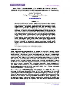
2.3. 5G and IoT Sensor Technologies for UAVs The 5G technology is expected to enhance mobile broadband, enable applications that require ultrareliable very low latency and very high availability networks, improve traffic safety and control, support industrial applications, remote manufacturing, training, surgery, logistics, tracking, and fleet management. It will be utilized for smart agriculture, precision farming, smart buildings, smart meters, support of 4K/8K UHD broadcasting, virtual and augmented reality without range limitations, including homes, enterprises, and large venues offering massive and critical Machine-To-Machine-Type Communications (MTMC) [29]. This type of device communications can be integrated with typical Human-Type Communications (HTC) through suitable gateways in the context of a 5G architecture, as presented in Reference [30] and illustrated in Figure 1.
Figure 1. Unmanned aerial vehicle (UAV)-enhanced 5G-enabled Internet of Things (IoT) services.
Other 5G use cases that are linked to drones involve automation and robotics. Drones with the support of 5G networks would be able to offer a wide variety of tasks and applications providing new benefits to a wide range of industries. Among the top use cases of 5G-enabled drones, we consider applications related to construction, agriculture, insurance claims, police, fire, coast guard, border control, journalism, news, utilities, filmography, and logistics. All these applications will be feasible since autonomous and beyond line-of-sight control will be supported. In order to enable these use cases, specific minimum requirements for aerial vehicles are essential in terms of equipment and sensors. The main types of sensor technologies that are supported and are a part of drones today can be separated into three main categories: (a) flight control, (b) data acquisition, and (c) communication sensors. 2.3.1. Flight Control Sensor for Internal State Evaluation Accelerometers are used to determine position and orientation of the drone in flight. One type of technology senses the micromovement of embedded structures in an integrated circuit. Thermal sensing is another technology used in accelerometers, which does not include any moving parts but instead senses changes in the movement of gas molecules passing over a small integrated circuit [2]. Drones and UAVs manage to maintain flight paths and directions using inertial measurement units combined with GPS. The Inertial Measurement Units utilize multiaxis magnetometers (available in one to three axes). A magnetometer is basically a magnetic compass
Sensors 2018, 18, 4015
6 of 21
that can measure the magnetic field of Earth. This mechanism helps in determining the direction of a compass and, consequently, of the drone, which is estimated with respect to the magnetic North. The flight-control system, in order to maintain level flight, obtains input from tilt sensors combined with accelerometers and gyroscopes. This is an essential element for UAVs, especially when the applications require high level of stability (e.g., surveillance, delivery, etc.). In certain drones we have Engine Intake Flow and current sensors [31]. These UAVs are powered with gas engines to effectively monitor the air flow and sensors to estimate the proper fuel-to-air ratio at a specified engine speed aiming to reduce emissions and the overall consumption. Current sensors are available in drones to monitor and optimize power consumption and detect faults with motors or other areas of the system. 2.3.2. Data-Acquisition Sensors Drones are equipped with several sensors to capture information and data that are required to perform certain tasks. Depending on the application, the payload sensor suite can be arranged during the development of the drones. • •
•
For military use cases, UAVs may be equipped with high-end electro-optical sensors, and radars for airborne systems providing resolutions from submillimeters to a few centimetres. In surveillance and monitoring applications, we can have sensors at the lower end of the spectrum, such as low- or high- (e.g., 4K) resolution RGB (Red Green Blue) cameras, NDVI (Normalized Difference Vegetation Index) cameras for precision farming, LIDAR (Light Imaging, Detection, And Ranging) for simultaneous localization and mapping, and ultrasonic sensors for sense and obstacle-avoidance methods. We can also have hyperspectral depth and thermal sensors [32]. Applications that monitor environmental and weather conditions and are deployed in disaster relief and management require sensors to measure or detect liquefied petroleum gas (LPG), butane, methane (CH4), hydrogen, smoke, oxygen, temperature, and humidity.
In all these applications, the IoT sensors collect data in real time and are either processed on board if enough power is available or transmitted to a base station. 2.3.3. Communication Systems Managing and controlling tasks for UAVs are performed through communication systems and networks [33]. In the case of multiple drones, technologies are required to allow them to communicate with each other for safety reasons. There are different types of communications, and some of the main types used in UAVs are listed in Table 1. An extensive list of network protocols and communication techniques for generic IoT devices can be found in Reference [34]. Based on the coverage range, available data rates, and latency specifications, it is evident that 5G technology would impact drones’ communications, enabling several worldwide applications. In such a conceptual model, UAVs can form infrastructureless dynamic network segments of the IoT architecture, which are interconnected to the core network for the provision of demanding services, such as surveillance multimedia streaming [35].
Sensors 2018, 18, 4015
7 of 21
Table 1. Categories of communication technologies available to UAVs. Category WPAN WPAN WLAN WLAN LPWA LPWA Cellular Cellular Cellular Cellular Cellular
Technology Bluetooth 4.0 Zigbee 802.11a/b/g/n/ac WAVE 802.11p LoRA SigFox NB-IoT LTE-M LTE Advanced (4G) LTE D2D 5G
Data Rate