Vehicle Collision Detection Algorithm at T-shaped intersections Based on Location Based Service Pin Wang1, Shou’en Fang1, Lanfang Zhang1, Junhua Wang1, Shuo Liu1 1
Key Laboratory of Road and Traffic Engineering of the Ministry of Education, Tongji University, 4800 Cao’an Highway, Shanghai, 201804, P. R. of China, E-mail:
[email protected] ABSTRACT: Collisions at intersections are considered a main contributor to the relatively high accident rates in China. One of the reasons is that drivers cannot get the full information needed to make an objective judgment about road conditions ahead. If collision detection is made and issued before drivers notice the danger, it would be of great importance for improving the traffic safety. In this paper, we proposed a collision detection algorithm to determine the possibility of collisions at T-shaped intersections based on Location Based Service (LBS), which integrates Global Positioning System (GPS), Inertial Measurement Unit (IMU), and other vehicle sensors to provide real-time state information of the vehicles approaching to the intersection. Results showed that the successful warning rate is as high as 81.7% which indicates that the detection method is effective for alerting drivers to dangers beforehand. Keywords: Collision Detection Algorithm, Cooperative Collision Warning System, Tshaped Intersection, Location Based Service INTRODUCTION Intersections on local streets are accident-prone locations in most countries. In the United States, the accidents on intersections account for 36% of total accidents. In European countries, the rate reaches to around 43%, in Japan 42.2% and in China 30% (Wei, 2012). If a Collision Warning System (CWS) based on vehicles’ current locations is used to offer drivers real-time warning message and help alert them to take proper maneuvers in advance, the number and severity of collision accidents could be significantly reduced. A survey conducted by NHTSA (National Highway Traffic Safety Administration) has revealed that if collision warning messages are provided one second earlier, the accident rate at intersections can be reduced by 50% to 90% (Vord, 2001). Therefore, timely and accurate collision detection based on real-time location is of great importance to the drivers. Turning maneuvers at intersections are complex and dangerous operations as they need drivers to pay more attention to road conditions, like oncoming traffic and traffic from the left and right sides. It is especially the case at intersections without traffic lights where vehicles do not need to be fully stopped. In some developing countries, like China, there are no stop signs at non-signalized intersections so that drivers need to self-
consciously slow down to check the traffic and decide whether it is safe to pass through. In this situation, it is not easy to clearly observe the traffic from other legs of the intersection and make the right decision about when to turn. It is even worse when buildings, trees, or parked vehicles at roadside block the driver’s vision. CWS is now commonly applied to vehicles to alert drivers of such dangerous situations. However, the poor accuracy of the warning systems is an annoying problem, which leads drivers to distrust the system or even totally shut it down. A solution to improve the accuracy of the warning system is to design a robust and effective detection algorithm to make good use of the real-time information of the vehicles. In our paper, we focused on putting forward a collision detection method to detect the occurrence probability of collisions at intersections. Since turning-straight conflict at T-shape intersections is a typical conflict type, we investigated the specific scenario that left-turn vehicles on branch road come across vehicles on the main road in a T-shaped intersection. Location-based Service (LBS), which can offer location-specific applications that are based on real-time positions of the users, is an active area in ITS. It integrates Global Positioning System (GPS), Inertial Measurement Unit (IMU), and other vehicle sensors (VS) together to provide location related information to users. The technology is well under developments in the United States, Japan, and European countries (Mountain, 2001; Choi, 2003; Kupper, 2005; Steiniger, 2006), while in China the research has just started (Liu, 2008). We conducted our experiment based on the technology of LBS. Information is transmitted via Dedicated Short Range Communication (DSRC) among vehicle-to vehicle (V2V) and vehicle-to-infrastructure (V2I). The paper is organized as follows. In section 2, related work is described to present a general idea about the relevant research. Section 3 explains the collision detection algorithm we developed in the paper. Section 4 gives the simulation results. Conclusions and discussions are presented in Section 5. RELATED WORK CWS which aims to provide drivers early warning messages of the potential collisions, are under lots of research in recent years. CWS is one of the primary themes in the field of Intelligent Transportation System (ITS) and one of the active topic areas in road safety. In CWS, it is evaluated whether the subject vehicle may collide with other objects (stationary or moving) based on their positions, velocities, accelerations and heading angles, and then determine whether to issue warning massages. Data are usually collected by sensors, such as radar/lidar (Giubbolini, 2000; Kato, 2002), acoustic (Kuc, 1989) and vision sensors (Steinfeld, 2004 ). However, they are subject to the line of sight constraints and lidar system cannot work reliably under bad weather. Furthermore, each vehicle detects potential collisions based only on the information obtained by itself, and there was no communication with other vehicles and road infrastructure.
Others make a further step to investigate Cooperative Collision Warning System (CCWS) that enables vehicles to exchange their real-time information with road infrastructure (V2I) and neighboring vehicles (V2V) through advanced communication technologies, such as Zigbee and DSRC (Tang, 2010). America, European countries and Japan are the earliest countries to conduct researches on this field. Partners for Advance Transportation Technology (PATH) (Sengupta, 2007) implemented a CCWS in real test system that could provide warnings for a variety of situations, such as lane change, forward collision, and blind spot. The collision detection module yields satisfactory results but relies heavily on infrastructure and accessories to achieve precise location prediction, like differential GPS, vehicle sensors (VSs) and digital map that are not universally available now. Salim et al. (Salin, 2007) devised a new CCWS based on collision patterns acquired from abundant data mining work but the false alarm rate is relatively high when a certain collision pattern happens to be excluded from the established knowledge base. Redmill et al. (Redmill, 2001) integrated GPS and INS to calibrate measurement errors for precise localization, and it improved the positioning accuracy but the collision detection is not elaborated. Rezaei et al. (Rezaei, 205) used the bicycle model to fuse DGPS and VSs to estimate vehicles’ positions which performed favorably, but the model was nonlinear and complex. Tu and Huang (Tu, 2010) moved a step further and introduced a triple Kalman filter, consisting three independent linear Kalman filters, to provide accurate estimation of vehicle positions and speeds. And the effectiveness of warning algorithm was analyzed in details. It makes much sense to explore a robust and effective collision detection method to guarantee the reliability of the warning system. Because if a collision warning system issues unnecessary or even false alarms to drivers, it would not only annoy drivers but also make them distrust the warning system, and some users may directly shut it down. Therefore, developing a precise collision detection algorithm for a CCWS bears much significance. Normally, there are positioning errors in GPS and drifts in IMU, which affect the measurement accuracy of the vehicle state, such as positions, velocity and yaw angle. A common way to deal with the errors is to use Kalman filter to fuse GPS and IMU data to suppresses the shortcomings of each one of them. Desirable results were shown in a number of studies (Rafael, 2007; Rezaei, 2007). In our study, we also adopted Kalman filter to process the data collected from GPS and IMU in order to improve the positioning accuracy, which was a part of our research. Since here we focus on the collision detection algorithm not the positioning and communicating modules, the details of data processing is not included in this paper. Whereas, we elaborate on the details of how to make collision detections of the vehicles approaching to intersections based on the optimized dataset. Our study is based on the following assumptions: 1) all the vehicles approaching to the intersection are equipped with LBS-based equipment, such as GPS and IMU, and vehicle information is transmitted between V2V/V2I via DSRC; 2) the positioning accuracy and transmission time meet the requirements of the CCWS we are developing
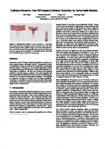
in which the positioning errors are below 1 meter and DSRC transmission time is within 100ms. COLLISION DETECTION ALGORITHM At T-shaped intersections, the merge and cross conflict types are shown in Fig. 1.
Fig. 1 Conflict Types at T-shaped Intersection Among these conflict types, the situation that the left-turn vehicle on the branch runs across the straight driving vehicle on the main road (left-straight conflict) (lower left in Fig. 1) is one of the most dangerous situations. Drivers usually fail to notice the vehicles coming from the main road when making left turns since the maneuver needs more attention and operation. Therefore, our collision detection algorithm is developed to investigate such situation. Conflict Area Defining the conflict area is necessary for the detection of potential collisions. For the left-straight conflict situation, the conflict area is displayed in Fig. 2.
Fig. 2 Conflict Area for Left-straight Conflict In Fig. 2, the ABCD area is the conflict area which includes all the conflicting points when a left-turn vehicle meets a straight driving vehicle. The vehicle on the branch road is the subject vehicle (SV) and the vehicle on the main road is the private other vehicle (PV). Consider all the possible travelling trails of SV and PV, the edges of the driveways are considered as the farthest traveling boundaries of the vehicles. When SV makes a left turn, B is the furthest and first point that SV reaches and D is the last point that SV leaves. For the straight driving vehicle PV, D is the first point that PV hits and B is the last point that PV leaves. Since vehicles can communicate with infrastructure at the intersection, it can get the coordinate information of the intersection from the e-map. Therefore, the boundaries of the conflict area can be known from the geometric parameters. The relevant parameters and calculation equations are displayed as follows: 𝑊" ---the width of the branch road; 𝑊# ---the width of the main road; 𝑊$% ---the width of SV; 𝐿$% --- the length of SV; 𝑊'% --- the width of PV; 𝐿'% ---the length of PV; 𝑆" ---the distance between the current location of SV and the edge of conflict area AB; 𝑆# ---the distance between the current location of PV and the edge of conflict area AD;𝐷*+, ---the deceleration distance of SV before entering the intersection; 𝑅# ---the radius of the outside arc of the conflict area; 𝑅" ---the radius of the inside arc of the conflict area; 𝑎* --the deceleration of SV; 𝑣$% ---the current speed of SV; 𝑣$%,1234 ---the turning speed of SV; 𝑣'% --- the current speed of PV. 𝑊# 𝑅" = 2 𝑅# = 𝑊#
𝑂" 𝐾 = 𝑎𝑟𝑐