Nat. Hazards Earth Syst. Sci., 11, 487–500, 2011 www.nat-hazards-earth-syst-sci.net/11/487/2011/ doi:10.5194/nhess-11-487-2011 © Author(s) 2011. CC Attribution 3.0 License.
Natural Hazards and Earth System Sciences
Verification of surface minimum, mean, and maximum temperature forecasts in Calabria for summer 2008 S. Federico1,2 1 ISAC-CNR, 2 CRATI,
UOS of Lamezia Terme, Lamezia Terme (CZ), Italy Rende (CS), Italy
Received: 5 July 2010 – Revised: 26 November 2010 – Accepted: 17 December 2010 – Published: 16 February 2011
Abstract. Since 2005, one-hour temperature forecasts for the Calabria region (southern Italy), modelled by the Regional Atmospheric Modeling System (RAMS), have been issued by CRATI/ISAC-CNR (Consortium for Research and Application of Innovative Technologies/Institute for Atmospheric and Climate Sciences of the National Research Council) and are available online at meteo.crati.it/previsioni.html (every six hours). Beginning in June 2008, the horizontal resolution was enhanced to 2.5 km. In the present paper, forecast skill and accuracy are evaluated out to four days for the 2008 summer season (from 6 June to 30 September, 112 runs). For this purpose, gridded high horizontal resolution forecasts of minimum, mean, and maximum temperatures are evaluated against gridded analyses at the same horizontal resolution (2.5 km). Gridded analysis is based on Optimal Interpolation (OI) and uses the RAMS first-day temperature forecast as the background field. Observations from 87 thermometers are used in the analysis system. The analysis error is introduced to quantify the effect of using the RAMS first-day forecast as the background field in the OI analyses and to define the forecast error unambiguously, while spatial interpolation (SI) analysis is considered to quantify the statistics’ sensitivity to the verifying analysis and to show the quality of the OI analyses for different background fields. Two case studies, the first one with a low (less than the 10th percentile) root mean square error (RMSE) in the OI analysis, the second with the largest RMSE of the whole period in the OI analysis, are discussed to show the forecast performance under two different conditions. Cumulative statistics are used to quantify forecast errors out to four days. Results show that maximum temperature has the largest RMSE, while minimum and mean temperature errors are similar. For Correspondence to: S. Federico (
[email protected])
the period considered, the OI analysis RMSEs for minimum, mean, and maximum temperatures vary from 1.8, 1.6, and 2.0 ◦ C, respectively, for the first-day forecast, to 2.0, 1.9, and 2.6 ◦ C, respectively, for the fourth-day forecast. Cumulative statistics are computed using both SI and OI analysis as reference. Although SI statistics likely overestimate the forecast error because they ignore the observational error, the study shows that the difference between OI and SI statistics is less than the analysis error. The forecast skill is compared with that of the persistence forecast. The Anomaly Correlation Coefficient (ACC) shows that the model forecast is useful for all days and parameters considered here, and it is able to capture day-to-day weather variability. The model forecast issued for the fourth day is still better than the first-day forecast of a 24-h persistence forecast, at least for mean and maximum temperature. The impact of using the RAMS first-day forecast as the background field in the OI analysis is quantified by comparing statistics computed with OI and SI analyses. Minimum temperature is more sensitive to the change in the analysis dataset as a consequence of its larger representative error.
1
Introduction
This paper investigates the performance of the highresolution (2.5 km horizontal resolution) operational forecast of minimum, mean, and maximum temperatures issued by CRATI/ISAC-CNR for the Calabria peninsula (Southern Italy, Fig. 1). Temperature forecasts are produced daily by the Regional Atmospheric Modeling System (RAMS; Cotton et al., 2003). The model horizontal resolution was enhanced from 6 to 2.5 km in June 2008 and this paper shows the forecast performance from 6 June to 30 September 2008 (112 runs out of 117 days because the forecast was not available for 5 days).
Published by Copernicus Publications on behalf of the European Geosciences Union.
488
S. Federico: Verification of surface minimum, mean, and maximum temperature
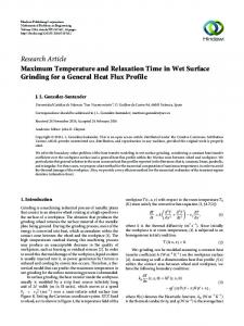
Fig. 1. (a) Calabria features cited into the text; (b) Calabria region and its position in the central Mediterranean; (c) Black-filled circles are the stations of the regional network. Grey shading shows the orographic height (m).
Figure 1: a) Calabria features cited into the text; b) Calabria region and its position in the central Mediterranean; Black-filled The orography of Calabria is complexc)for three main circles reasons (Fig. 1a): the sea-land contrast; mountain peaks with shading shows the orographic height (m). elevations greater than 1000 m near the shoreline (