A Mobile Guide System Framework for Museums Based on Local Location-aware Approach Jianga Shang1,2, Shengsheng Yu1, Fuqiang Gu2,Zhanya Xu2, Liangfeng Zhu3 College of Computer Science and Technology, Huazhong University of Science and Technology , Wuhan, China 1 Information Engineering Faculty , China University of Geosciences, Wuhan, China 2 Key Laboratory of GIS for Ministry of Education, East China Normal University, Shanghai, China 3
[email protected] Abstract—Location-aware applications based on local wireless networks ,like Wi-Fi, RFID, are becoming more realistic and attractive for many research and commercial organizations in recent years. In this paper, we provide comprehensive analysis on key characteristics of museum mobile guide system with locationaware features, including related location technologies, context structures, and available system architecture firstly. Then the pervasive location-aware service software framework for museum mobile guide is presented, which adopts layered and plugins-based architecture. This framework enables the development of location-aware applications for mobile guide, in a way independent of localization technologies and make easy. Keywords-Museum; mobile guide system; Location-aware; wireless network; software framework
I.
INTRODUCTION
At the core of ubiquitous computing is context awareness, the concept of sensing and reacting to dynamic environments and activities[1,2]. Context can consist of any number of components, including user identity, current physical location, time, and even user preferences. One of the most critical physical context parameters is location, because most other physical and situational context properties can be determined as functions of place and time. With numerous factors driving development of context-aware technologies, location-aware computing is becoming a part of daily life [3]. A museum provides physical surroundings for touring people to acquire knowledge [4]. For a long time, museums are always being used as crucial facilities to promote culture broadcasting and tourism development worldwide. And in order to attract more visitors, the managers of museums is invariably to do everything possible, like adding sorts and number of exhibits and improving service quality by introducing new technologies. With the improvement of science and technology, the touring service approaches evolve constantly, which have went through several phases in modern: the form of written board and pamphlets; tour guides commendatory; traditional audio guide form; smart mobile multimedia guide form. As a common guidance form, board-based text notes are inconvenient for visually impaired people, children and older people. Therefore, many museums employ guides to provide vivid descriptions to make up the deficiency of the above media form. Unfortunately, due to the limited human resources
978-1-4244-9763-8/11/$26.00 ©2011 IEEE
1935
guide can only provide group guidance, and are unable to guide each visitor individually. With the development of speech and language processing technology, many museums began to develop and apply audio guidance systems. The Phoenix Museum of History first used audio guide device in the world in 1959[5].This kind of audio guide system requires the visitor to carry an audio player and to operate the device according to the exhibition information that he or she saw to play the pre-recorded voices. However, under most circumstances, visitors do not know the correct information about the exhibition, like name, no, or only remember part of the characteristics of that. In recent years, there has been growing interest in the development of mobile guides because of the wide spread mobile and small devices(like PDAs, mobile phones, RFID tag, etc.) and increase in the performance of them, the progress of wireless communications and improvements in localization technologies. Compared with the traditional audio guide devices, these handheld guide devices can provide rich form of exhibition content presentation such as pictures, text, videos, etc. and interaction capabilities and therefore improve visitors experience greatly. In this case, visitors do not need to follow fixed sightseeing routes and can freely select the content related to an object. Modern handheld digital guide devices have the advantages of being easy for carrying, large storage space compared with early mobile devices. Moreover, they are similar to PCs and cellular phones in functions and interaction form and therefore it is very easy for those who have visiting experience or are familiar with digital devices, like PDAs, etc. to operate them. There have been many academic and commercial attempts to provide the mobile guide services for visitors in public museums [5]. Whichever of traditional audio player system and handheld mobile guide system requires visitors to input certain identity information, which is considerably inconvenient for ordinary visitors, especially for older people, children and handicapped, even it is impossible to executive such operation in some cases. Moreover, these systems can not utilize existing visitor information, such as background knowledge and preferences, to provide appropriate service for them. Actually, the museum is a particularly suitable context-aware computing scene in which it can be done to experiment with new interaction techniques for guiding mobile users and improve their experience. By using context information such as the user’s
location, time, preferences, and current task, the systems can provide visitors with context-dependent services based on the context-aware computing paradigm. A system with greater intelligence, interactivity and adaptability to different types of people represents a future direction of museum guide domain. In the last decades years, many of the mobile guide systems with part of the above characteristics have been developed, most of which are academic projects and provided portable multimedia terminals or PDAs to visitors. One of the first examples of the mobile guides with context-aware features was Cyberguide[7], which supported navigation in-building environment or outdoors, visualizing a schematic map of the area, automatically updated according to the user’s position, which was determined by the infrared sensors (indoors) or GPS (outdoors).Since then some of the primary powerful nations of science, technology and art in the world, like USA, Japan, Spain, Italy, Greece etc.[411,17], began to research and develop the context-aware mobile guide system. In Table 1, we summarize the main system characteristics of the Museum guide applications discussed in the above, which some of them have been put into operation. As shown in Table 1, these systems generally adopted location methodologies, such as RFID(Radio Frequency Identification), Wi-Fi(IEEE 802.11), Bluetooth, Infrared etc.. TABLE I. System /Project Tour Guide System[C.Y.
MOBILE GUIDE SYSTEMS WITH LOCATION-AWARE FEATURES
Localizatio n Technology Wi-Fi
Achitechture style
Active/ Passive
C/S
Passive
Extra Device
RFID
non-centralizd
Active
Screens
UbiCicero[G.
RFID
Stand-alone
Active
Screens
WiFi, Bluetooth Bluetooth
C/S
Active
B/S
Both
PhoneGuide[E.
Bluetooth
C/S
Passive
Euro Flora exhibition[F.Bel
RFID
Stand-alone
Active
Rememberer[
RFID
B/S
Passive
RFID, Optical RFID
C/S Stand-alone
Active
IR,GPS
C/S
Active
[I. Satoh,2009]
Ghiani,2009]
[Pasquale
GITA
Pace,2008]
E-Museum project[A.
Zafeiropoulos,2007]
Bruns,2007]
cameraequipped mobile phones
lotti&al, 2007]
Dimitrios
Cameras
Raptis,2005]
Ec(h)o[(Hatala
andWakkary, 2005]
The interactive system[Mantyjarv i,2006]
Cyberguide[Gr egory,1997]
II.
LOCAL LOCATION-AWARE TECHNOLOGIES
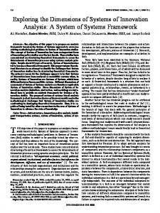
As is known to all GPS (Global Positioning System) is the most frequently adopted location determination system worldwide. Unfortunately, GPS does not work properly in indoor environments or urban areas because of signal blockage and attenuation as well as accuracy, cost, energy consumption etc[2,3,4]. However, the main work place of museum mobile guide is just indoor environments. Considering this fact, recent years have seen the rapid growth of local wireless location market which is based on communication technologies including Wi-Fi, Bluetooth, RFID, UWB(Ultra Wide Band), ZigBee(IEEE 802.15.4) , Infrared, Ultrasound etc. , and the potential market is enormous. Many Real-time locating systems grounded on these technologies have been implemented, and many pioneering applications have been made on some domains like industrial automation, health care, logistics, manufacturing, entertainment, environmental disaster monitoring, mine and security etc[2,3,12-15]. Among the technologies aforementioned, Infrared belongs to optical positioning technology, Ultrasound belongs to acoustic positioning technology and others belong to electromagnetic positioning technology. To distinguish from Wireless Local Area Network (WLAN) based on Wi-Fi, we are accustomed to call the wireless network on the basis of Bluetooth, RFID, UWB and ZigBee as Wireless Personal Area Network (WPAN) [13]. For location systems using the above technologies, they can be classified into two kinds according to the existence of network infrastructure (Figure 1): The first is location system using existing infrastructure network, in this kind of system the infrastructure is usually already existed, at least not existed for pure localization reason. We can just add some hardware and software to the existing network infrastructure to implement the localization function. Another system is based on dedicated network infrastructure, whose network does not exist before and needs to be built for location-aware function. In general, the systems using the existing infrastructure network have a lower cost than others using dedicated network which need additional investments on the network hardware.
Tsai,2010]
Agent System
based on a certain special location technology and aimed at special application. It is not the ease with which the systems can accommodate its software to different types of location technologies. The systems have higher cost of development and deployment, lower maintainability and reusability. Consequently, it constrains a wide spread and application of the systems. So, it is essential for us to exploit a software framework which can support often-used location technologies in mobile guide of museum. In particular, the software allows users to select appropriate location technology for their application with less development cost and has greater flexibility and expandability.
There is no doubt that the existing mobile guide systems with context-aware, particularly location-aware characteristics have promoted greatly service quality and the level of museums. However, most of the systems were developed This research is supported by the fundamental research funds for the central universities (No.CUGL090247) and the National Natural Science Talent Training Foundation of China under Grant (No.J0730534 ).
1936
Figure 1.
information such as time, position, scene , device information such as the size of screens, processing ability and user information such as identity, operation habit, personal preference and emotion etc. In the context-aware applications, there are four key issues: context acquiring, context modeling, context management and context inference. The acquiring, modeling, management, and inference of other context generally can be calculated based upon location context and thus location context is the most basic and important in all contexts. So this section will focus on the handling of the location context.
Classification of local wireless positioning technology
III. DOMAIN ANALYSIS OF MUSEUM MOBILE GUIDE SYSTEM WITH LOCAL LOCATION-AWARE FEATURES A. Localization technology analysis of the location-aware mobile guide Through the above analyses we can see that all local localization technologies have its advantages and disadvantages on cover range, accuracy, cost, and volume etc. Currently the most widely used technologies in museums are Wi-Fi, RFID, Barcode, Infrared, Bluetooth, and so on. To achieve the precise guide based on the exhibit localization, the relevant information should be put into the tag or signal emitter first, and then attach the tag or signal emitter to the exhibit. Thus when visitors are in front of the exhibit they can receive the related information transmitted from the tag or the signal emitter. As there are usually a large number of the collections in the museum, most exhibition rooms change its exhibits on occasion except some conventional ones. If we adopt Wi-Fi, Infrared, or Bluetooth localization technology, when changing the exhibition objects, we will have to confront with the problem of reconfiguring the cable or adjusting the coordinate of the reference points. The cost of changing exhibition in this way is considerably high. If we adopt RFID technology, we can just change RFID tags when adjusting exhibit and we needn't to reconfigure the cable. And it can also guarantee the exhibit objects' security. When choosing a localization technology, we should consider its function, cost, deployment, maintenance and many other aspects all together. We can select a single kind of technology or the integration of several kinds of technologies. H.Y. Lin [5] has discussed the pros and cons of current common solutions of exhibit localization. If the exhibition area is indoor and the distance between objects is not so far, then the high accurate RFID+Wi-Fi solution would be a good choice. Therefore, in terms of the existing technologies, he suggests to adopt RFID+Wi-Fi solution. But other new technologies like ZigBee and nanoLOC[15] also deserve to follow with interest because of their high cost performance and a wide applications prospect in the market. It's also recommended to try to integrate these technologies with traditional RFID and Infrared in mobile guide. B. Context analysis of the location-aware mobile guide Theoretically speaking, all the information that can describe the environment and the state of a entity while a user is interacting with applications can be called context. Context can be dynamic or static. The common context information of a mobile guide system in museums include environment
1937
In the location-aware mobile guide system, to provide the right information in the right place, it's necessary to have the ability of awareness in physical and virtual space. To fit the requirement of the space location-awareness, the system should provide location representation of exhibition rooms, exhibitions and visitors, including the coordinates, the reference coordinate system, the distance function, the topological relationship and directions etc. For example, to express "in front of exhibition A", you can use the location description method topology-based, but in most situations, you should use the strict description method Cartesian coordinatesbased, because in the mobile guide system, a change of information in the virtual space is depend on the moving information of users in the physical space, and thus the reasoning between physical space and virtual space is implemented. For instance, we must know related coordinates information if we want to put the user’s position on the map of the museum. And in a museum that is full of exhibitions, only by the Cartesian coordinate method can we get the accurate position representation. Under many circumstances, distances and directions are also used to describe position. Considering the following example, when a user is approaching an exhibition, the system can point out that "you are approaching...","you are in front of...".It becomes considerably important to describe the moving direction of the visitor in the system with navigation function. In the location-aware mobile guide system, the time context is the time an visitor spent on an artwork, which can be a factor to infer the user's preferences; the device context is mainly about the size of the screen, processing ability and the network state of a interactive device, which this kind of context will directly influence the validity of information transferred to the user. Because in the mobile guide applications, the space-time dimension constantly changes as the visitor moves, and correspondingly the information the system transferred to the user should also be adjusted, and the adjusting technology differs as the application changes. Besides, there are other contexts such as operation habit(like repeatedly executing one operation),operation history, personal preferences, personal knowledge background and so on. By handling these context users can interact with system in a better manner. For example in a system that has a center server, when the user intend to connect to the server, it's possible to ask the user to answer some questions on such as languages, speciality and other special needs, thus the system can build relevant user model, and offer adaptability interaction. In the mobile guide environment of the museum, context can be classified as two kinds according to mobility: fixed
component and mobile component. The fixed component, such as screens, are put in fixed positions. Despite the screen has its shortcomings, it can also play an important role in the interaction between the users and the system. User experience can be enhanced by the multimedia technologies, and the screen can show more information than a PDA, which becomes more important for group visitors. The mobile component, mainly a PDA, is a mobile device used the most widely in mobile guide. By using the device, people can not only obtain information also record information, and can communicate with others to cooperate in some work. Users can be treated as another kind of object that has mobility who uses the assets in the environment. Generally speaking, a device like PDA can only be used by one person, and the screen can be used by many persons but there are some security problems. C. Architechture analysis of the mobile guide service system Current mobile guidance systems can be classified as follows: 1) stand-alone system: For this kind of system,the audiovideo data are stored in the user guide device(for instance a PDA) and visitors are expected to use these systems on their own.For the systems equipped with tags, visitors should firstly sense the tag and then listen to the guide speech.The advantages of this kind of system:data are stored in local device and therefore the response time of playing is considerably quick, and no investment of extra network infrastructure is needed;Disadvantages:the memory of the guide device should be large enough, and the workload for updating data is too much. 2) Client/Server system: For this kind of system, guidance audio-video data are stored in the LAN server. Visitor firstly get the number of the exhibits by sensing the tag and then request for appropriate guide content.For example, a visitor can use the RFID Reader in a PDA to sense the tag and read the number of the exhibits, then the PDA will use the number to query the relevant content in the database which subsequently transfer information back to the PDA.The advantages of this kind of system: the data stored in the LAN server is easy to be shared and updated.And it has a high security. Disadvantages: The investments of the network infrastructure are needed, the cost is higher than stand-alone system, and the playing quality may be lower than stand-alone system. It's also easy to be influenced by the network environment. 3) online guide system:Systems of this type are similar to those in type 2,except that the visitor can obtain information using the internet at the exhibition site via wireless Access Point (AP).The advantages of this kind of system:Besides the advantages of type 2,the system can also take advantage of the Internet, like distributed data sharing in a large range,supporting more online users and remote system / data maintenance;Disvantages:Data access is limited by network bandwidth limitations ,play respond is usually slow, easy to be attacked when connected to WAN, and it's harder to develop. 4) Agents system: Unlike the above systems, this kind of system is implemented by using mobile agent technology [10]
1938
and the system information is managed through a noncentralized manner. When a visitor with tags moves from exhibit to another, location-aware service-provider agents can be dynamically deployed at computers near their current locations and then present multimedia information of the exhibits in terms of the contexts of his or her knowledge, interests. The advantages of this kind of system: System is not dependent on the server, and Robustness is better. Disadvantages: This kind of system has a higher requirement of the hardware infrastructure, and the technology is more complex, and the system run at a low efficiency. Currently, compared with other technologies, the agents system is still immature as a new kind of mobile guide technology, the ability to support large scale application need to be verified further. IV.
A MUSEUM MOBILE GUIDE SYSTEM FRAMEWORK WITH LOCATION-AWARE FEATURES
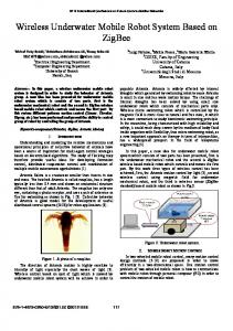
In this paper, we focus on analyzing the requirements of location-aware mobile guide fields, and then designed a technology-independent framework of location-aware Mobile Guide for museum. The framework adopts a layered structure and a plug-in-based extend technology, which belongs to C/S style architecture and consists of several high level components: client, application server, system manager, content manager system(CMS) (Figure 2).
Figure 2. The achitechture of Location-aware Mobile Guide System
A. The Client Software Architecture The client software is a network agent program that runs on a client device (PDAs, tag, etc.), which is a device that is tracked by the system. It has the layered structure (Figure 3), which includes several primary components: location interface, communication, visualization. The location interface consists of a series of interfaces supporting localization plugins, which is used to acquire the measured signal of different location technologies. After getting the necessary signals, the client will transmit it to the location engine which is the core part of the application server, and the location engine will calculate the position. Then it is possible to access the content in the mobile
device by combining the location information with the content. The visulization component is responsible for the content presentation and the interaction between user and the system by the Graphic User Interface. This software should run on the J2ME framework in the mobile terminal. The client can connect the server via the Wi-Fi network.
locations and properties for administrative purposes, drawing logical areas (or locales), testing live positioning, and analyzing positional accuracy etc. D. The Content Management System The content management system is designed to manage multimedia information about exhibit content and provides them to mobile terminals, such data as image, audio, video. In general, content management functions can be built based on an existing commercial or open source CMS [9], so it's unnecessary to build a entirely new content management system. V.
Figure 3. The achitechture of client plugin-based
B. The Application Server Software Architecture The application server includes several primary components: the location engine, non-location context handling, core module, context fusion, application service-provider and so on(Figure 5).The main function of the location engine is to receive RSSI,TOF and other measured information, then calculate the position of the object with a certain algorithm; non-Location context handling component is designed to handle the context information of the user, including the artwork information, the time that the visitor spent on an exhibit, his or her preferences. The context fusion component is designed to implement the combination of the location information with the non-location information, add semantic feature to the position and form a integrated user model to lay the foundation of further inference and service; The core module is designed to implement the communication with the server with other nodes, the access to the context model database and the event record etc. The application serviceprovider component is designed to provide relevant services based on the user context inference.
Figure 4. The achitechture of the Application server software
C. The Manager Software The Manager Software is an integrated management tool software package running on back-end computers(PC laptop), and it can be a stand-alone or C/S application architecture for the following functions: creating and managing positioning model of the area, loading and configuring location maps, restricting/allowing networks and APs, displaying device
1939
CONCLUSION AND FUTURE WORK
Mobile guide system in museums is a typical application of location-awareness which has become core element of contextaware computing. By integrating location-aware computing based on WLAN or WPAN technology such as RFID and WiFi, we can greatly promote the intelligentization degree of mobile guide in science museums, improve the service quality and enhance the users’ experience. With the introduction of new technologies and thereby the improvement of guide service quality, museums will certainly attract more and more visitors. In mobile guide system based on location-awareness, the most important issue is to localize a visitor. However, from the above discussions we can see that nowadays there isn't one kind of location technology or system that is suitable for all situations (from indoor to outdoor) and at the same time meet all kinds of requirement (cost, accuracy).Usually, the developer of the location-aware application system may adopt different solutions for different location technologies and this give rise to a long developing period, low extensibility and reusability. It is desired to allow an application to dynamically select localization technology and even the terminal mobile device in museum mobile guidance to some extent. Aiming at the above problems, this paper provides a comprehensive analysis on key characteristics of museum mobile guide system with location-aware features, including possible location technologies, context structures, system architecture. And then a location technology-independent software framework of museum mobile guide system was presented, particularly which adopt plug-ins technology to support different location technologies in one system. The framework hides the difference between location technologies and what’s more makes developing a application project easy based on it. At present we are using Java to develop related components according to the design idea of the framework. Future work will include to choice typical museums or science museums to develop and test application system based on the software framework. ACKNOWLEDGMENT We would like to thank our team members, particularly Ao Guo and Pingyuan Chen for helping collate related materials and improve the writing of this paper.
REFERENCES [1] [2]
[3] [4] [5]
[6] [7] [8] [9]
G.Y. Xu, Y.C. Shi, W.K. Xie, “Pervasive/Ubiquitous Computing,” Chinese Journal of Computers, vol. 26, no. 9, 2003, pp. 1042-1050. M. Mühlhäuser ˈ I. Gurevych, “Handbook of Research on Ubiquitous Computing Technology for Real Time Enterprises,” New York˖IGI Global, 2008, pp. 235-282. M. Hazas, et al., "Location-aware computing comes of age," Computer, vol. 37, pp. 95-97, 2004. C. Y. Tsai, et al., "Location-aware tour guide systems in museums," Scientific Research and Essays, vol. 5, pp. 714-720, Apr 2010. H.Y. Lin, “From audio to video: Talking about how to programming mobile guide in museums, ”National Museum of Natural Science, http://www.nmns.edu.tw/php/Library/quaterly/200601_97.pdf D. Raptis, et al., "Context-based design of mobile applications for museums: a survey of existing practices," 2005, pp. 153-160. G. Ghiani, et al., "UbiCicero: A location-aware, multi-device museum guide," Interacting with Computers, vol. 21, pp. 288303, Aug 2009. P. Pace, et al., New Wireless Communication Architectures for Interactive Fruition of Historical and Artistic Contents, 2008. A. Zafeiropoulos, et al., "A Lightweight Approach for Providing Location based Content Retrieval," in Personal, Indoor and Mobile Radio Communications, 2007. PIMRC
1940
2007. IEEE 18th International Symposium on, 2007, pp. 1-5. [10] I. Satoh, "Context-Aware Agents to Guide Visitors in Museums," in Intelligent Virtual Agents, Proceedings. vol. 5208, H. Prendinger, et al., Eds., ed, 2008, pp. 441-455. [11] R. Tesoriero, et al., "A Location-Aware System Using RFID and Mobile Devices for Art Museums," in Autonomic and Autonomous Systems, 2008. ICAS 2008. Fourth International Conference on, 2008, pp. 76-81. [12] Y.H. Wu, C.C. Wu, X.W. Chen, “Introduction to several WLAN location technologies of indoor environment,” http://mobilecomputing.ctocio.com.cn/282/7800282.shtml,2008 -02-01. [13] Ajay Malik, “RTLS for Dummies. Indianapolis,” Indiana:Wiley Publishing, Inc, 2009, pp. 1-303. [14] S. Jianga, et al., "Location-Aware Systems for Short-Range Wireless Networks," in Computer Network and Multimedia Technology, 2009. CNMT 2009. International Symposium on, 2009, pp. 1-5. [15] Y. Liu, Z. Yang, X. Wang et al, “Location, localization, and localizability,” JOURNAL OF COMPUTER SCIENCE AND TECHNOLOGYˈvol. 25, no. 2ˈ2010, pp. 274-297. [16] C. Becker and F. D¨¹rr, "On location models for ubiquitous computing," Personal and Ubiquitous Computing, vol. 9, pp. 20-31, 2005. [17] E. Bruns, et al., "Enabling Mobile Phones To Support LargeScale Museum Guidance," Multimedia, IEEE, vol. 14, pp. 1625, 2007.