trieval of rain rate over the open ocean from SSM/I multichannel imagery. This algorithm takes a more detailed physical approach to the retrieval problem.
NASA-C_-202_97 Repnnted Irom the Dr_pnnt volume ot SEgE.NTN CONF'_RENCE ON SATELLITE METF::OROLOGY AND OCE.ANOGRAPWY
June r'r-lO
_jbl_shod by thO American M_tQoroto_cal $o_e_
A NEW
3.3
INVERSION-BASED
ALGORITHM
OVER-WATER SSM/I
RAIN
MULTICHANNEL Grant
W.
David
R.
Purdue _Vest
1
in particular the Special (SSM/I). Most of the al-
gorithms that have been published for this sensor are empirical or else are based on highly simplified physically derived relationships between single-scene microwave observables and rain rate. Representative examples include those described by Adler et al. (1993), Grody (1991), and others too numerous to list here. Two published retrieval techniques take a far more detailed physical inversion approach; these include the algorithm described by Kummerow and Giglio (1994) and the Mugnai/Smith algorithm described by Mugnai et al. (1993) and references therein. These algorithms perform explicit forward radiative transfer calculations based on detailed model hydrometeor servations
profiles and attempt to match the obto the predicted brightness temperature.
The purpose
of this
paper
is to discuss
certain
as-
pects of a new inversion-based algorithm for the retrieval of rain rate over the open ocean from SSM/I multichannel imagery. This algorithm takes a more detailed physical approach to the retrieval problem than the first class of algorithms mentioned above; at the same time, it avoids much of the complexity and computational burden of the Kummerow and Mugnai/Smith algorithms. Furthermore, despite the lack of prior empirical calibration, the prototype implementation performed respectably in two major algorithm intercomparison efforts -- the NASA WetNet 1st Precipitation Intercomparison Project (PIP-l: Barrett et al. 1994) and the Global Precipitation
Climatology
Project
• Corresponding
Author
and Atmospheric 1397
Sciences
144
Address: Dept.,
(GPCP)
2nd
Grant West
W.
Lafayette,
AMERICANMETEOROLOGICALSOCIETY
Algorithm
Petty, IN,
OF
FROM
Petty" Stettner
University
During the past few years, there has been a great deal of activity in the area of rainfall estimation from microwave sensors, Microwave/Imager
RETRIEVAL
MA
IMAGERY
Lafayette,
INTRODUCTION
passive Sensor
FOR
RATE
_994 Mon'ie_v
Boston
Earth 47907-
Indiana
Intercomparison coming noted factor of 2. The
Project (AIP-2). The main shortwas an apparent low bias of about a
full details
of the
algorithm
as originally
im-
plemented appear in a recent pair of papers by Petty (1994a,b). Details of its performance in the PIP-1 and AIP-2 intercomparisons may be found, respectively, in Barrett et al. (1994) and in a report scheduled for release by WCRP. The emphasis here will be on the impact of subsequent adjustments to the algorithm and on preliminary new validation results.
2
ALGORITHM
The principal distinguishing features of this rithm relative to other published rain rate rithms may be summarized as follows: The
starting
point
for
the
inversion
algoalgo-
is not
the raw brightness temperature fields from the SSM/I but rather normalized polarization differences P for 19.35, 37.0, and 85.5 GHz, coupled with an 85.5 GHz scattering index Sss. Petty (1994a) showed that the use of these single-frequency indices allows one to effectively separate radiative extinction (attenuation) due to precipitation from other geophysical variables (e.g., water vapor, surface wind speed, scattering by ice aloft) and, conversely, to reliably isolate the 85.5 GHz volume scattering signal from other sources of 85.5 GHz brightness temperature variability. Scattering and attenuation may thus be treated completely independently in the inversion algorithm, and background variability unrelated to the tion signal itself may be ignored.
precipita-
Observed
19 and
rain
cloud
attenuation
at
37
GHz serves as the primary basis for the rain rate retrieval, with 85.5 GHz scattering supplying
information
only
in the
event
of heavy
CA
R (Fa
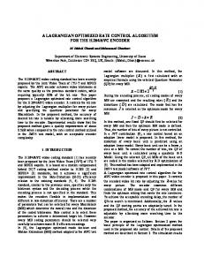
Fig. 1: information
Logical structure of the rain rate algorithm. in the SSM/I muhichannel imagery (equation
rain exceeding channels.
the dynamic
range
of the 19 GHz
* The inversion procedure entails an iterative adjustment of a 12.5 km resolution rain rate field in order to bring forward calculations of FOVaveraged normalized polarization at 19.35 and 37 GHz into approximate agreement with the corresponding observed fields. Because the forward calculation of normalized polarization involves only simple analytic functions of total cloud optical depth rather than full radiative transfer calculations, the algorithm is computationally efficient relative to other physical inversion methods. Also, this inversion strategy is unusual among current algorithms in its explicit treatment of footprint-filling effects. 3
CALIBRATION
Two aspects of recent will be discussed here. of 12.5 km gridboxes
calibration/validation efforts The first is the classification as "no rain"
or "possible
rain".
Most indicated operations make numbers refer to Petty 1994b).
use of spatial
The second is the effect of minor adjustments in the scaling between observed scattering (Sss) and the first-guess rain rate field on algorithm biases relative to tropical atolls. :Z1
No Ra:n/Poss:ble
Ram
Classification
One of the fundamental measures of the performance of any instantaneous rain rate retrieval algorithm is whether it correctly del:neates the area of significant precipitation, irrespective of retrieved intensity. For the algorithm described here, the issue is particularly important, since the spatial distribution of "no rain" pixels strongly constrains the inversion in many cases. The classification is based on a threshold of the normalized 85.5 GHz polarization difference Pss, since this index is most sensitive to the presence of significant liquid water and allows areas of probable rain to be delineated with 12.5 km resolution. As published, an ad hoc threshold of Pss < 0.413 was employed based on the arbitrary assumption that FOV-averaged column liquid water amounts L in excess of 0.5 kg m -= (corresponding to
7TH CONF.SATELLITEMET. & OCEAN.
145
AUGUST 1987 800
I 0.2 _,
_=
'
instprob ip. I I I Inst. prob. non-drizzleprecip. ,_ Inst. ram excl. I light I Isnow :_t Inst. prob. prob.precip,
_
* P85threshold 0.300 [
_
: P85threshold 0.350
I
I
_ 4
_,
1_[
11 m2 3_ 6OO ----.m 114 115 116 -117--
/.
/
to.,,, 0 -6o
-40
-20
o Latitude
20
40
0
6O
Fig. 2: COADS precipitation frequencies lines) for 34 years compared with SSM/I threshold-based frequencies for SON 1987.
/
,m"
o
Fig.
(gray P85
P85 -_ 0.213) was likely to occur only in the presence of rainfall and that there was likely to be a random uncertainty of ,'-0.2 in the modeled relationship between Pss and L.
8O0
200 400 600 ATOLL RAINFALL (ram) 3:
quency of rain (excluding drizzle and frozen precipitation) at approximately 45°N, while the agreement at far southern latitudes is excellent. Based on these results, we can find no basis for adjusting threshold employed in the "no rain"/"'possible determination.
the
Pss rain"
that
the
One aspect of the algorithm's performance which distinguished it from all others in PIP-1 was its retrieval of comparatively frequent precipitation at very high latitudes, especially south there is little published information
of 50°S. While concerning ex-
pected climatological frequencies of over-ocean precipitation at those latitudes, the fact that most other participants in PIP-1 saw very little, if any, precipitation there was a cause for concern. We therefore
analyzed
a 34 year
record
of ship-
board present weather reports from the Comprehensive Ocean-Atmosphere Data Set (COADS) in order to derive a reasonable climatology of precipitation frequency over the global oceans. Fig. 2 depicts as gray lines the latitudinal dependence of precipitation frequency for various classes of precipitation. At latitudes between 40 o and 60 o (both hemispheres), precipitation is seen to be quite frequent, actual
even when rain.
one excludes
all forms
other
than
Superimposed on those plots are solid black curves depicting the "'possible rain" frequency inferred from three different P85 thresholds for SON 1987. Throughout the middle and low latitudes, the match between COADS precipitation frequencies and the occurrence of P8_ < 0.4 is remarkably good. For reasons which are not yet understood, the P8_ criterion appears to significantly overestimate the fre-
146
AMERICANMETEOROLOGICALSOCIETY
3.2
Validation
A clear first ical this tor rain
result
Against of the
Tropical PIP-1
Atolls
exercise
was
version of the algorithm underestimated troprainfall by about a factor of two. Even before result was known, an unusually low scaling facbetween 85.5 GHz scattering and the first-guess rate field was discarded in favor of one more in
keeping with theoretical modeling results (see Petty 1994b for details). Since the first guess rain rate plays a particularly important role in regions of deep convection, the revised algorithm was used to recalculate monthly rain rate fields for August 1987 and the results compared with the tropical atoll data set of Morrissey et al. (1993). Atoll reports were divided up into non-overlapping groups falling within 2.50 boxes; the average of these groups was compared box.
with
the
SSM/I
estimate
The size of the markers number of atolls contributing
within
dramatically as the to the 2.50 estimate
each
in Fig. 3 indicates the to the rainfall average
within the respective grid box. In general, ment between satellite and atoll estimates improve tributing
that
the agreeis seen to
number of atolls increases.
con-
Table deg.
1 Statistical and tropical
for August
comparison between SSM/I (2.5 atoll monthly rainfall estimates
1987.
Min. Atolls 1 2 3
R_on (mm) 2:27.6 239.3 217.6
.V 35 9 6
R,_t (mm) 177.5 204.5 237.9
quency of "--0.08 at 40-50°S. our algorithm's estimate of--.t30 mm/month implies an average rainfall rate. conditioned on the occurrence of rain. of 0,17 mm hr- l .4cknowledgments
Ratio 0.78 0.85 1.09
r 0.77 0.83 0.97
This work was supported NAGW-2984 and NAGS-918.
by
NASA
Grants
REFERENCES AUGUST 80
1987 .MEAN LATITUDENAL I 1 I
PRECIPITATION 1 I
Adler, 60
40
--
PIP-1 CALIBRATED
E -20 N
OCEAN
ON'LY
4*0
-80 50
100 150 200 .MEAN PRECIPITATION
250 (ram)
300
350
Fig. 4: Latitudinal oceanic rainfall for August 1987 from the uncalibrated algorithm submitted to PIP-1 and from the current version.
3.3
Latitudinal
In order gorithm
Averages
to assess modifications,
the
overall latitudinal
effect
Negri,
P.R.
Keehn,
and
of various
averages
[R data.
J. Appl.
Meteor.,
I.M. rainfrom and 32,
Barrett, E.C., R.F. Adler, K. Arpe. P. Bauer, W. Berg, A. Chang, R. Ferraro, J. Ferriday, S. Goodman, Y. Hong, J. Janowiak. C. Kidd, D. Kniveton, M. Morrissey, W. O[son, G. Petty, B. Rudolf, A. Shibata, E. Smith, R. Spencer, 1994: The first WetNet Precipitation Intercomparison Project: Interpretation of results. Submitted to Remote Sens. Rev.
0
0
A.J.
geosynchronous 335-356.
20
-40
R.F..
Hakkarinen, 1993: Estimation of monthly fall over Japan and surrounding waters a combination of low-orbit microwave
al-
of over-
Grody,
the latitudinal averages found in the tropics. Rainfall estimates at high latitudes are certainly higher than those yielded by many other algorithms, but there is as yet little reliable basis for confirming or refuting any specific estimate in those data sparse regions. If one accepts the COADS rainfall ire-
1991:
Classification
of snow
cover
using the Special Sensor MiJ. Geophys. Res., 96, 7423-
Kummerow, C.D., and L. Giglio 1994: A passive microwave technique for estimating rainfall and vertical structure information from space. Part I. Algorithm description. J. Appl. Meteor., 33, 3-18 Mugnai,
ocean rainfall were calculated for August 1987 and compared with results obtained with the prototype version of the algorithm submitted to PIP-1. The results appear in Fig. 4. The net result is a consistent increase by a factor of 1.5-2.0 of estimated rainfall, with somewhat larger increases over the far North Atlantic Ocean, and with somewhat smaller increases (as low as 20%) near 55 °. Given the absence of a significant bias relative to the tropical atolls, there is no reason to disbelieve
N.C.,
and precipitation crowave Imager. 7435.
A.,
E.A.
Foundations tion retrieval measurements.
Smith,
and
G.J.
generalized weighting function time dependent cloud-radiation Meteor.. 32, 17-39 Petty,
1993:
properties of a model. J. Appl.
G.W., 1994a: Physical retrievals of over-ocean rain rate from multichannel microwave imagery. Part I: Theoretical characteristics of normalized polarization in Meteorol.
Petty,
Tripoli,
for physical-statistical precipitafrom passive microwave satellite Part II: Emission source and
G.W.,
and scattering Atmos. Phys.
1994b: Physical
indices.
retrievals
To appear
of over-ocean
rain rate from multichannel microwave imagery. Part II: Algorithm implementation. To appear in Meteorol. Atmos. Phus.
7TH CONF, SATELLITEMET, & OCEAN.
147