monitors, and computer controlled variable rate application equipment, that provide an opportunity for improving upon traditional approaches of treating ...
An E-commerce System for Mining Distributed Spatial Databases Aleksandar Lazarevic, Dragoljub Pokrajac, Zoran Obradovic
Abstract--Due to restrictive data access and a lack of appropriate data mining software, spatial information from physically dispersed sites is often not properly exploited in ecommerce. In the proposed distributed spatial knowledge discovery system for e-commerce, a secure centralized server collects proprietary heterogeneous data from subscribed businesses as well as relevant data from public and commercial sources and then integrates knowledge to provide valuable management information to subscribers. Considered knowledge discovery methods include: (1) providing estimated values for unobserved, typically expensive attributes of interest to a particular business; or (2) delivering learned models for generalizing extracted knowledge. An evaluation on large, highly nonlinear simulated data suggests that both approaches can provide profitable, effective and useful management recommendations in spatial e-commerce applications.
I. INTRODUCTION In various e-commerce domains involving spatial data (real estate, environmental planning, precision agriculture), participating businesses may increase their economic returns and improve environmental stewardship using knowledge extracted from spatial databases. However, in practice, spatial data is often inherently distributed at multiple sites. Due to security, competition and a lack of appropriate knowledge discovery algorithms, spatial information from such physically dispersed sites is often not properly exploited. Many large-scale spatial data analysis problems also involve an investigation of relationships among attributes in heterogeneous data sets. Instead of applying global recommendation models across entire spatial data sets, designing an ensemble of local models is preferable to better match site-specific needs thus improving financial benefits [1]. One of the applications that may prosper from novel techniques for analysis of spatial data is precision agriculture aimed at lowering production costs and protecting the environment by controlling the environmental characteristics at a sub-field level [2]. This can be achieved by collecting more and better information and by extracting useful knowledge from data, so the The authors are with School of Electrical Engineering and Computer Science, Washington State University, Pullman, WA 99164-2752, USA. Zoran Obradovic is also with Center for Information Science and Technology, Temple University, Philadelphia, PA 19122, USA.
farmers can make the more suitable decisions and thus successfully accomplish their multifaceted goals. This is possible by employing technological advances, such as global positioning systems, combine-mounted yield monitors, and computer controlled variable rate application equipment, that provide an opportunity for improving upon traditional approaches of treating agricultural fields uniformly. Profitability of precision agriculture, the risk of equipment incompatibility and its obsolescence are one of the largest concerns listed by farmers, who are generally interested in this new approach, especially if the costs are modest. A possible approach towards overcoming all these limitations is developing a distributed spatial knowledge discovery system for precision agriculture. In the proposed system a centralized server provides methods for conversion of protocols and data formats, such that customers have not to be concerned about data incompatibility due to obsolete and non-standardized equipment. The server collects proprietary site-specific spatial data from subscribed businesses as well as relevant data from public and commercial sources and integrates knowledge in order to provide valuable management information to subscribed customers. In general, there are two methods for providing useful recommendation actions. The first method assumes distributed spatial data sets with different sets of attributes. Here, the estimation for unobserved (typically expensive) attributes of interest to a particular business can be made according to similarity among the observed attributes with data from another source where the desired attribute is available. The second method includes constructing models for generalizing knowledge extracted from spatial data and delivering them to subscribed customers. However, sometimes the prediction problem in spatial data sets can be extremely complex since a large number of attributes may influence the target attribute and also significant amounts of noise can exist in data. Given a number of distributed, both heterogeneous and homogeneous spatial data sets, a profitability evaluation of the proposed methods is discussed in Section 2. Extensive experimental results, reported in Section 3, provide evidence that both methods can be computationally efficient and fairly helpful in developing useful management decisions in precision agriculture and other spatial e-commerce applications.
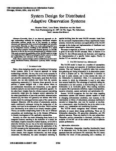
wireless communication channel
satellite telemetry systems
SERVER
…
secure communication standard communication
WWW Customers
Fig. 1. The scheme of acquiring information to the secure centralized server
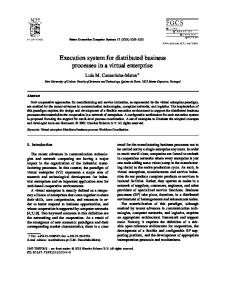
II. METHODOLOGY In the proposed distributed spatial knowledge discovery system farmers interested in improving their management are subscribed to the centralized server, and they communicate to the server through a wireless communication channel. The system collects two groups of relevant spatial attributes from subscribed businesses. The first group consisting of x and y coordinates and the target attribute is collected by integrating the combine-mounted yield monitors and GPS units. The second group of relevant attributes includes typically expensive soil characteristics which are not necessary available from all farmers. After performing a local data reduction [3] all attributes are transferred through a wireless channel to the centralized server (Fig. 1). In addition to obtained information from subscribed customers, the server acquires relevant information from other sources available on the World Wide Web (WWW). Publicly available relevant information needed for giving profitable advises include an average temperature, air humidity, precipitation etc., as well the forecasts for those attributes. Commercial information of interest include topographic attributes e.g. slope, elevation, topographic indices, etc. and they are collected through miscellaneous business services, e.g. global positioning systems (GPS), satellite telemetry systems, remote sensing etc. (Fig. 1). The server uses commercial services for acquiring relevant information for all customers, and it shares the costs among all subscribed businesses, hence allowing customers to gain interesting information for less money. In addition, customers are provided with many useful recommendations resulting from integrating knowledge obtained from other subscriber’s data. A. Telecommunication subsystem A telecommunication sub-system (Fig. 2) consists of the base station located at the site of the central server and mobile stations located on each of harvesting machines that collect crop yield information. Base and mobile stations communicate through a wireless communication channel. A
mobile station collects crop yield information, requests communication and after the request is acknowledged, starts with transmission of a data packet from its transmitting buffer ( in Fig. 2). Each data packet contains collected data as well as information for control, error correction and mobile station identification. In the meantime, new-collected data are gathered into an acquisition buffer. The base station receives messages, identifies the sender, and performs error control. If an error in data transmission is detected and cannot be corrected, the base station requests retransmission of an information packet from the corresponding sender by broadcasting the request code along with the sender id ( in Fig 2.). When a wireless channel is not available, a mobile station retries data transmission after a fixed or a random time interval ( in Fig. 2). A telecommunication subsystem can utilize either of accepted wireless data-transmission multiplex techniques [4]: frequency (FDMA), time-division (TDMA) or code-division multiple access (CDMA). In this paper, we suggest an application of Carrier-Sense Multiple Access/Collision Detection (CSMA/CD) systems that belong to the class of TDMA [5]. �
�
In CSMA/CD systems, there is no centralized assignment of the channel to a particular user. Instead, transmitter perceives the channel and starts transmission if there is no signal detected. Due to a propagation delay, another transmitter may broadcast at the same time, when a collision occurs. Once a collision is detected, transmitter retransmits according to one of adopted algorithms. In the simplest case, non-persistent CSMA/CD, which is to be discussed afterward, retransmission occurs after a random time interval. In this paper we will discuss following aspects of an applied telecommunication system: • • •
the maximal number of mobile stations an average number of retransmissions the size of an acquisition buffer
Transmission buffer
MOBILE
MOBILE
STATION 1
STATION 2
Error control, Flow control
Transmission buffer
Acquisition buffer
Acquisition buffer
Yield monitor
Yield monitor
Error control, Flow control
MOBILE STATION 3
Transmission buffer
…
Error control, Flow control
Acquisition buffer Yield monitor
1
3
2
Wireless communication channel
I. B
Receiving buffer
Error control, Flow control
Server
Fig. 2. The scheme of the telecommunication subsystem
1) The maximal number of mobile stations Recall that a yield monitor with global positioning system (GPS) collects one record with the current latitude, longitude and crop yield information each tc seconds. Let P is the size of transmitting buffer, of which P’ bytes are reserved for the transmission of collected records. The maximal number of mobile station Nmax can be estimated using the theory of maximal line utilization [5] as: P’ t f c B
N max ≤
ρ max P b = λm 1 + 6.44 2df B cP
(1)
where ρmax is the maximal line utilization, λ is customer arrival rate, m is the customer average service time, d is the average distance between a mobile and a base station, fB is the system byte transmission rate, b is the number of bytes per data record and c is the light speed. The maximal number of mobile stations increases with the increase of fB, tc and P’ (assuming that the number of control bytes P-P’ is constant) and decreases with the increment of b and d. Typically, sampling rate tc depends on required yield sampling density and thus cannot be arbitrarily varied. Also, the size P of transmission buffer is limited due to economic reasons. Transmission rate fB depends on the bandwidth of a wireless channel. On the other hand, the number of bytes per data record depends on the resolution of collected data, while the average distance d depends on various factors, such as the carrier frequency of wireless channel and terrain configuration. For typical values of parameters: d = 20 km, P = 2Kbytes, fB = 8KBytes/s, tc = 1s and b = 10 bytes, we obtain small values of propagation delay 0.13ms, and a high maximal line utilization, ρmax = 0.996. If we choose utilization ρ = 0.8 (to prevent problems that can occur when working near maximal utilization) and assume P’/P>0.5 (which is rather
pessimistic), we obtain Nmax=320 that satisfies practical requirements for the maximal number of users in an agriculture system 2) The average number of retransmissions The number J of retransmissions due to collisions satisfies geometric distribution [5] with the average number of retransmissions Javg=1/v, where v=Np(1-p)N-1 is the probability that an attempted transmission occurs without a collision. Parameter p is the probability that in a given moment a particular station occupies the channel. Using an expression for the average time for a successful transmission in the case of non-persistent CSMA/CD [5] the probabilities v and p can be shown to satisfy: v = Np (1 − p )N −1
m 2df B 2 + p = 1 + 1 tP cP v
(2)
For adopted values of system parameters, after few iterations of (2), one can obtain p=0.0025 and v=0.196. Hence, the average number of retransmission is Javg≈5. 3) The size of an acquisition buffer While re-transmitting, a mobile station acquires new data. To accomplish the quality of service, the probability that data overflows an acquisition buffer must be held within specified boundaries. Given a small probability α, we choose the size B of an acquisition buffer such that 2τb (3) Prob B ≥ J + P ’ > 1 − α t c Due to a geometric distribution of J, it can be shown that the size of an acquisition buffer must satisfy:
B≥
2τb log α + P’ t c log(1 − v )
(4)
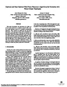
Unmanageable attributes
Unmanageable attributes Crop yield Model
Manageable attributes
a) Inverse modeling
Model
Manageable attributes
Crop yield
b) Direct modeling
Fig. 3. Basic modeling approaches in agriculture KDD process Therefore, the size of the acquisition buffer must be larger that the size of the transmission buffer. However, due to τ