An interoperable Spatial Decision Support System based on geospatial semantic web technologies Chuanrong Zhang∗a, Tian Zhaob, Weidong Lia Department of Geography, Center for Environmental Sciences and Engineering, University of Connecticut, Storrs, CT USA 06269, USA b Department of EECS, University of Wisconsin -- Milwaukee, USA 53201
a
ABSTRACT Many Spatial Decision Support Systems (SDSSs) have been developed for environmental and natural resources decisionmaking in recent years. However, an important limitation of the SDSS applications is that they are not interoperable. Several issues prevent the further development of SDSS applications such as the incapability of sharing and reusing existing heterogeneous data and geoprocessing. This paper proposed a framework of web services-based interoperable SDSSs using geospatial semantic technologies such as ontology, web services and service-oriented architecture for decision-making. The proposed interoperable SDSS enables decision-makers to reuse and integrate geospatial data and geoprocessing from heterogeneous sources across the Internet. Based on the proposed framework, a prototype to assist in protective boundary delimitation for Lunan Stone Forest Conservation has been implemented to demonstrate how ontology-based web services and the services-oriented architecture (SOA) contribute to the development of interoperable SDSSs. Keywords: Spatial decision support system (SDSS), web services, ontology, service-oriented architecture, geospatial semantic web
1. INTRODUCTION Many Spatial Decision Support Systems (SDSSs) have been developed for environmental and natural resource decisionmaking in recent years (e.g., Anderson and Moreno 2003; Armstrong 1993; Carver 1999; Jankowski et al, 1997, 2001, 2006; Van Der Perk et al., 2001). However, an important limitation of the SDSS applications is that they are not interoperable. The geospatial data and geoprocessing resources distributed by them cannot be shared and interoperated. While there is an increase in the number of SDSS applications over the past two decades, most of them did not take advantage of the Internet’s distributed nature by sharing spatial data and geoprocessing software (Ostländer 2004; Rinner 2003). Several issues prevent the further development of SDSS applications. One issue is that most SDSSs were developed independently of one another and they are typically standalone systems incapable of sharing and reusing existing data and processing functions. They have their own proprietary system designs, database storage structures, and process models. Thus, it is difficult to communicate and exchange spatial information among these systems, and decision-makers usually cannot integrate data and geoprocessing resources from these systems. The integration of data and modelling software from disparate sources was beyond the thechnological capabilities of many potential users (Sengupta and Bennett 2003). The second issue is the duplication problem caused by current SDSSs’ incapability of sharing and reusing existing data and geoprocessing. Because of the lack of interoperability, accessibility and availability of data and information, redundant efforts are commonplace in the development of SDSS applications. Thirdly, it is time-consuming to obtain geospatial data when implementing SDSSs. Geospatial data capable of supporting desired analyses often did not exist or was too expensive to acquire (Sengupta and Bennett 2003). Although many geographical databases have been developed, geospatial data sharing and acquisition is still a big problem because of the heterogeneity of existing systems in terms of data modeling concepts, data encoding techniques, storage structures, and other related reasons (Devogele et al. 1998; Zhang and Li 2005). For the development of a SDSS, the issue of how to aquire data rapidly from
∗
[email protected]; phone 1 330 672-2046; fax 1 330 672-4304 Geoinformatics 2008 and Joint Conference on GIS and Built Environment: The Built Environment and Its Dynamics, Lin Liu, Xia Li, Kai Liu, Xinchang Zhang, Xinhao Wang, Eds., Proc. of SPIE Vol. 7144, 71442B · © 2008 SPIE · CCC code: 0277-786X/08/$18 · doi: 10.1117/12.812831 Proc. of SPIE Vol. 7144 71442B-1
2008 SPIE Digital Library -- Subscriber Archive Copy
different sources becomes important. Decision supports demand that the right information be available at the right time for making the right decision. Fourthly, while it is recognized that maintaining the most up-to-date geospatial information is important to aid in right decision making, it is difficult to keep consistent updated data in SDSS applications. To facilitate data sharing in SDSS applications, when data are updated at one source the change should be automatically updated in other closely associated applications. However, in current SDSS applications, automatically updating databases from disparate sources produced by different agencies cannot be realized with conventional database management. Finally, it is costly and time consuming to develop a new SDSS from scratch. Although many small companies and government agencies want to develop SDSSs to make decision-making easier, they cannot afford it because of limited or declining resources. It is often more cost effective to reuse existing data and software via interoperable SDSSs than to develop new databases and custom software. A solution that builds on existing data and geoprocessing rather than starting a new one from scratch is needed. There is an increasing demand for the development of interoperable SDSSs to reuse geographical data and geoprocessing. The emergence of OGC web services provides a way to overcome the heterogeneity problem of spatial databases and geoprocessing (Peng and Zhang 2004; Zhang et al. 2003a; Zhang and Li 2005). Users can "wrap" existing heterogeneous data into a web service and enable many potential clients to use the service. OGC’s web services represent an evolutionary, standards-based framework that may enable seamless integration of a variety of online geospatial data and geoprocessing (OGC Interoperability Program White Paper, 2001). Power (2003) suggested that the next generation of decision support systems should be primarily service-based. Rinner (2003) and Sugumaran and Sugumaran (2005) proposed web services and the Service-Oriented Architecture (SOA) to be the next generation infrastructure supporting decision-making. Realizing that difficulty in linking data, analysis tools and models across organization is one of the important barriers to be overcome for developing integrated spatial decision-making and the great potential of web services, researchers began to move towards proposing and developing SDSS applications using OGC web services (Bernard et al. 2003; Keßler et al. 2005; Huang and Sheng 2006; Wang and Cheng 2006). In spite of this growing interest, most proposed or implemented SDSSs only emphasized technical interoperability via web services and didn’t pay attention to resolving semantic heterogeneity problems in SDSS (Bernard et al. 2003; Keßler et al. 2005; Huang and Sheng 2006; Wang et. al. 2004; Wang and Cheng 2006). However, one of the major problems in data sharing and interoperability is the differences in semantics used in different data sources (Egnehofer 2002). One of the limitations of web services is the lack of semantic description of its contents (Zhang et al 2007), this prohibits its ability to understand the queries and its inference capabilities. According to our knowledge, little has been published about how to design and implement a workable interoperable SDSS based on geospatial semantic technologies such as ontology, web services and the service-oriented architecture for decision-making. The main objective of this paper is to propose a framework of an interoperable SDSS based on geospatial semantic technologies such as ontology, web services and the service-oriented architecture in order to develop a web service based SDSS with semantically enriched web services for decision-making. The proposed framework should enable decisionmakers to reuse and integrate geospatial data and geoprocessing from heterogeneous sources across the Internet. Based on the proposed framework, a prototype has been implemented to demonstrate how geospatial semantic technologies overcome the aforementioned issues and contribute to the development of interoperable SDSSs. The implemented prototype addressed how to find and integrate existing heterogeneous data at the semantic level from diverse sources and how the services-based SDSS facilitates decision-making.
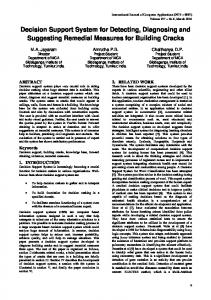
2. PROPOSED FRAMEWORK A framework of an interoperable spatial decision support system based on the geospatial semantic web technologies is proposed as shown in Fig. 1. The main objectives of the framework are: (a) to enable geospatial data and geoprocessing sharing at the semantic level over the web; (b) to maximize productivity and efficiency with geospatial data and geoprocessing sharing; (c) to overcome data duplication and data maintenance problems; and (d) to make it easy to integrate with other SDSS applications. The framework is based on independent geospatial semantic web services and the Service-Oriented Architecture (SOA) (Kishore et al 2003). It is essentially a collection of geospatial semantic web services, which communicate with each other by simple data passing or coordinating some activities. Applications and organizations using this approach can deploy spatial data and geoprocessing with different semantics over the web in real time so that information from diverse sources with incompatible data formats and semantics can work together transparently across the web.
Proc. of SPIE Vol. 7144 71442B-2
Service Provider
Service Client
,gWFS. WMS
Display and
Decision Proceasng
___ r
Web sever
Database
C0
0
I e: SOAPoverHTTP
A Web Service Based System for Decision Making
WPS;
0
,WFS.
C0
:i:ii—. WMS Web sever
I
WSDL&OWL-S
Ontology j 2 Server
WCS Database 21
1
\\\
WPS; WSDL & OWL-s
Fig. 1. Framework of an interoperable SDSS based on geospatial semantic technologies.
The SOA-based framework is composed of four elements: service provider, service broker, service client, and ontology server. Figure 2 illustrates the four components of the proposed framework in the logic universe. Service provider supplies heterogeneous geoprocessing and geospatial data from disparate sources via OGC Web Processing Services (WPS) (OGC document 05-007r4 2005) and data services such as Web Feature Services (WFS) (OGC document 04-094 2005), Web Map Services (WMS) (OGC document 04-024 2004), and Web Coverage Services (WCS) (OGC document 03-065r6 2003). The decision geoprocessing services can be chained to build specific spatial decision support services. Service client helps decision-makers display and manage data services and access decision processing services to generate and evaluate alternative solutions to semi-structured spatial problems. Service broker provides a registry for available services. Service broker uses ontology-based semantic Catalogue Services (CS) to register and manage the data and processing services and to allow users to search for these services at the semantic level. The ontology server ensures the semantic interoperability of the ontologies of service clients and providers. The web services are connected via Web Service Description Language (WSDL) (W3C 2001) and OWL-S (W3C 2004) among the service provider, the service broker and the service client. The Simple Object Access Protocol (SOAP) (W3C 2003) binding over HTTP is employed for communication between web services via the Internet. Unlike traditional web services, our service clients and providers must maintain local ontology at both the client side and the provider side to ensure the semantic interoperability. Local ontology at the service client refers to semantics used by the client user or client applications, while local ontology at the service provider refers to semantics used by the data providers. These local ontologies may address geospatial relations such as topological relations (e.g. connectivity, adjacency, and intersection among geospatial objects), cardinal directions (e.g. east, west, northeast), and proximity relations (e.g. the geographical distances among objects). The client ontology must be able to communicate with the provider ontology. Moreover, a service client may need to access multiple providers to complete a task. Thus, it is necessary to create mappings of equivalent or related classes and properties in the local ontologies. The ontology server is used to realize this function and it keeps a taxonomy of geospatial terminologies and maintains consistency for different local ontologies. The service broker uses the ontology server to map the standard OGC catalogue services to ontology-based catalogue services.
Proc. of SPIE Vol. 7144 71442B-3
OWL-S
Service Client (local ontology) OWL-S WFS/WMS Service Provider (local ontology)
OWL-S
Service Broker (OWL-S/Catalogue registry)
OWL OWL
OWL Ontology Server (ontology mapping)
Fig. 2. Service Components of Geospatial Semantic Web in the logic universe.
As the ontologies may be created by different communities, thus heterogeneity problems may arise when integrating the information from two or more ontologies. The G-Match algorithm proposed by Hess et al. (2006) is adopted in the framework to integrate geographic ontologies in the ontology server. The algorithm measures the similarities of the concepts of two different geographic ontologies by considering their names, attributes, taxonomies and conventional as well as topological relationship. Except for the name comparison, G-Match considers both the commonalities and the differences for measuring the similarity between two concepts. In the G-Match algorithm, each concept ci from an ontology O is compared against all concepts cj from ontology OO. The G-Match has three main phases of similarity measure in its execution: first, the concepts names (SimName(ci),cj) and attributes (SimAt(ci),cj) are compared. Then, using the results from the name similarity measure, the taxonomies (SimTx(ci),cj) relationships (SimRel(ci),cj) and topology relationships (SimTop(ci),cj) are evaluated. Finally, the overall similarity measure is estimated. To enable automation of the discovery, manipulation and composition of services, it is necessary to add a layer of semantics to the contents description through reasoning-based approaches and formal specification languages. By exploiting a well-tight semantic expressiveness of the ontologies for the conceptualization of the knowledge, the semantic web services can explicitly specify traditional web services at semantic level. OWL-S (Ontology Web Language for Services) is used to create semantically enriched web service descriptions in this framework. OWL-S is an upper-ontology based on OWL that can model the characteristics of web services. OWL-S has well-defined semantics based on OWL, making it computer interpretable and unambiguous. It also enables the definition of Web services content vocabulary in terms of objects and complex relationships between them, including class, subclass, and cardinality restrictions. OWL-S provides three modeling constructs at the top level, i.e., the service profile (what the service does), the service grounding (how the service can be accessed), and the service model (how to use the service in terms of semantic content). Through the three modeling constructs OWL-S overcomes problems caused by semantic heterogeneity in OGC web services and supports automatic discovery, composition, invocation and orchestration of these data services. The semantic catalogue service (or service broker) in the proposed framework is developed based on decidable description logic ontology language. The semantic catalogue service helps to automatically discover services that semantically match with a given service request, evaluated on the basis of the relationships among the concepts defined in the participating ontologies. The semantic catalogue service can enhance traditional catalogue service with semantic capability matching through the implementation of reasoner-based matching engine. Unlike the traditional service broker such as the OGC catalogue service that enables discovery and retrieval of metadata, the ontology-based catalogue service in the framework provides searchable repositories of service descriptions at semantic level and allows users directly searching and accessing geospatial information based on semantic content. Thus instead of providing resource-based metadata that describes services and data sets, the ontology-based catalogue service can allow users directly locate, access and make use of geospatial services and data sets in an open, distributed system. The main advantage of the ontology-based catalogue service is that it overcomes semantic heterogeneity caused by synonyms and homonyms during keyword-based search in standard OGC catalogues, which has been acknowledged by many studies (e.g. Fonseca et al., 2002; Cruz, et al., 2002; Klien et al., 2006; Lutz and Klien, 2006). To utilize web services effectively, users have to analyze service features and evaluate their applicability to the task at hand dynamically. Sometimes they may need dynamically bind component services or invoke these component services
Proc. of SPIE Vol. 7144 71442B-4
in a certain sequence at run-time to complete a personal need. The dynamic nature of the availability of web services, the large number of alternative combinations of service choices, and real-time requirements on service composition make the development of an integrated framework for the web service based SDSS a formidable task. In the proposed framework two steps are needed in facilitating automated dynamic service composition: First, based on the user’s request, locate possible services based on adequate descriptions. The rich semantics added to web service descriptions by OWL-S enable semantic composition by matching service capability descriptions at semantic level to requirements based on the aforementioned similarity measures. Second, based on the necessary control and data flow constraints among services, develop a service plan to invoke the execution among the services in the correct order. The service plan can be created and updated dynamically and is based on the centralized broker that manages the service composition process. The service plan needs to determine which service requests can be feasibly processed and which requests cannot be fulfilled. When one service cannot satisfy user’s request, the service plan will communicate and cooperate to other services to finish the composition service for the request. Thus the proposed web service based interoperable SDSS exhibits the systemic characteristics such as self-organization, evolution, scalability, and adaptability, although each of web services is not designed to do so.
3. PROTOTYPE IMPLEMENTATION 3.1 Prototype The Lunan Stone Forest, or Shilin, is the World’s premier pinnacle karst landscape. Located among the plateau karstlands of Yunnan Province, in southwest China, it is widely recognized as the type example of pinnacle karst, demonstrating greater evolutionary complexity and containing a wider array of karren morphologies than any other example (Zhang et al. 2003b). The area is designated as a national park covering a protected Shilin area of 350 km2, and is organized into three zones with different protection levels. But no much evaluation work was done when the protected-area boundaries were delimited in 1984. The designation of these boundaries are mainly based on the scenery beautiful values of the Stone Forest Landscape, and it has no relationship with the karst landscape itself or its natural values. Further the boundaries are drawn on a small scale (1:1,000,000) geological map. They almost have no relationship with the topography characteristics such as road, river, topography line, or geological character. Thus, to a great extent it is even difficult for the administrative officials to know the direction of the boundaries and to find out their exact location, not to say for the public and local residents. This brings difficulty to carry out the accordingly conservation regulations. An web-based SDSS for Lunan Stone Forest Conservation has been developed to provide a way to establish rational protective boundaries based on a variety of environmental and social criteria and render the location of the boundaries clear to the public (Zhang et al. 2005; Zhang et al. 2006). However, the developed web-based SDSS was based on traditional Client-Server architecture and was implemented using traditional computer technologies such as Visual Basic 6.0, ESRI Mapobjects 2.1 and ESRI Mapobjects IMS 2.0 and ASP (Active Server Pages) (Zhang et al. 2005; Zhang et al. 2006). Thus it is not an interoperable SDSS and has limitations for share and reuse of geographical data and geoprocessing although it indeed increased the public access to information and involvement in the decision-making processes for protective boundary designation decision-making processes. The objective of this case study is to develop an interoperable SDSS prototype to assist in protective boundary delimitation for Lunan Stone Forest Conservation based on the proposed framework shown in Figure 1. The interoperable SDSS prototype should facilitate share and reuse of heterogeneous geographical data and geoprocessing over the web. The prototype covers several components in the proposed framework, such as using OGC WFS and WMS services to access the heterogeneous spatial data connected to legacy GISystems, using OGC WPS to access the multiple criteria decision model for delimitation of the protected-area boundaries, using ontologies to describe the geographic information, using ontology-based semantic catalog services to register and discover the published WFS, WMS and WPS services, using similarity measurement approach to retrieve the ontology-based geographic information, using OWL-S and WSDL as service interface to connect service providers, service brokers and service clients, and using SOAP over HTTP for communication between web services over the web. Figure 3 illustrates the architecture of the prototype. The architecture consists of: (1) Data Service providers: • ESRI ArcGIS and PostGIS, which provide different format spatial data; • Geoserver (http://geoserver.sourceforge.net/html/index.php), an open-source software which enables full implementation of the OGC WFS and WMS specifications and serves ShapeFile and PostGIS data using WFSs and WMSs;
Proc. of SPIE Vol. 7144 71442B-5
• Apache Tomcat, a Java Servlet container, which hosts the web application GeoServer. (2) Web Processing Service providers: • A Multiple Criteria Decision Model to incorporate the interacting biophysical and social-economic criteria such as geology, geomorphology into the delimitation of the protected-area boundaries, which is implemented as WPS using Java; • J2EE, the underlying developing environment for the Multiple Criteria Decision Model; • Apache Tomcat: a Java Servlet container, which provides access to WPS. (3) Service brokers: • An ontology server, which maintains consistency for different local ontolgoies and is developed using Protégé software (http://protege.stanford.edu/); • An ontology-based semantic catalog developed by ourselves based on ebXML and Java API for XML registries (JAXR); • Oracle XMLDB, which provides capabilities for the storage and management of XML data for ontology-based catalog; • Apache Tomcat to act as container for the ontology-based Catalog. (4) Service clients: • We implemented the client using OpenLayers library to provide a user-friendly interface for decision-makers to query and access to ontology-based web services such as ontology-based WFS, WMS, WCS and WPS. OpenLayers is a JavaScript library for rendering maps and features from WFS/WMS servers and other map services from providers such as Google Map and Yahoo Map. Based on OpenLayers library, we implemented the client software. The implemented service client software provides functionalities of querying features from ontology-based WFS servers using OGC filters, retrieving the properties of features selected by mouse actions, and rendering ontology-based WMS maps based on customized style files. Moreover, the implemented service client software supports transactions on ontology-based WFS features that include addition, modification, and removal of features. In contrast to other WFS/WMS client software such as MapBuilder, the implemented client software provides better performance in map rendering and flexibility in editing geometries such as polygon.
M J
A Multiple Criteria Decision Model
Ontologies developed by proteges
Ontology-based Catalog
Web Service Based SDSS
GeoServer
GeoServer
Fig. 3. Architecture of the implemented prototype.
The same multiple-criteria decision model applied in the previous web-based SDSS (Zhang et al. 2005) was employed in this prototype but was recoded using Java computer programming language as web processing services. The multicriteria evaluation approach was widely used in GIS literature (e.g. Carver 1991; Eastman et al. 1993). Among many ways to integrate decision criteria, the weighted linear combination method is a popular one (Berry 1993; Hopkins 1977; Malczewski 1996; 2000) and was used to delimit different protected-area boundaries in this study. To rank the different protection level alternatives, the following formula was used:
Proc. of SPIE Vol. 7144 71442B-6
n
S =
∑WC i
(1)
i
i =1
where S is the suitability score with respect to the protection objective, Wi is the weight of the criterion i, Ci is the criterion score of i, and n is the number of criteria. The model has its own algorithm to make sure that Wi = 1. By
∑
using formula (1), overall protective suitability scores were determined and the whole area was divided into several different level protection zones. 3.2 Some Experimental Results Figure 4 shows the interface of the implemented interoperable SDSS for Stone Forest conservation (http://jiangxi.cs.uwm.edu:8080/stone-forest/gis.html Note: the SDSS works better with Mozilla Firefox than Internet Explorer). Through the prototype, decision-makers can delimit protective boundaries using the multiple criteria decision model based on a variety of biophysical and social economic criteria by employing ontology-based WFS, WMS, WPS and CS. Figure 5 shows one scenario of two different level protection areas that was delimited by using the prototype system. Note: in the prototype, the criteria data are stored in two different format databases (Shapfile and PostGIS) on two remote servers (http://qingdao.cs.uwm.edu:8080/geoserver and http://172.16.1.34). The multiple criteria decision model and the ontology-based Catalog software are held in the remote server (http://172.16,1.34 ). I 000110 FoofOO
L0JLJL?J
0
C
gb
p
0
-"C
A Spatial Decision Support SsteIn for Stone Forest Conservatton
Edit the protecte 0 area layer
Establishing Effective Protectis e Boundaries
• S o,v w hiliPoiO
Iko oocpholop
goolog,
______I •
Go boOk
1 3.5 823, 24.93412
Fig. 4. The interface of the web service based SDSS for Stone Forest conservation.
Proc. of SPIE Vol. 7144 71442B-7
p p p 0 y op
000
Coli
P'—A Spatial Decision Support System for Stone Forest Conservation
Edit the protected area layer Edit
®O5sgio
0
0 soioct poIsgo 0 dc',, poIsgo o doloio polygofl
o
• 0 IIo,, cottio
Establishing Effective Protective Boundaries • St loyc, hp,to,,,, l%l siIIgo dsoc
•L1Eovcosiaing
• 0 •IIo,, dcggig • disccdchoos
i,,p
IOISOP t 'v'p' 'H
cboos ioPcoioctadAco
Iko
Cobck
.ooqdoIogy
ip
!vp,do,t
goology c]p©dO]t Select Query Layer 0 goology
I
• Oho,k
0 id,, o —,
o o,o,phology
00 flog, sps 103.42551. 24.09143
Fig. 5. One scenario of two different level protection areas delimited by using the prototype system.
Using the implemented prototype, decision-makers also can render the location of the boundaries clear to the public by aligning them with conspicuous landscape features such as water bodies, roads or buildings via employing WFS, WMS and CS. The following experimental results demonstrate some advantages of the web services-based prototype SDSS: (1) The prototype system provides decision-makers with the ability to access and analyze heterogeneous criteria data in order to make better decisions for protected-area delimitation. It allows the decision-makers access the heterogeneous criteria data from a variety of sources on the Internet. The criteria data, such as geology, geomorphology, land use data, are stored in different databases with different formats on separate computers. However, decision-makers can directly access these heterogeneous data sources without having to know specifically who might provide the data and the format of the data. They need not contact data providers by email or mail to get the files and convert them into a format they need to start the decision-making task. In the implemented prototype decision-makers can seamless and dynamically integrate geology data (original in Shapefile format) located at the data server http://qingdao.cs.uwm.edu:8080/geoserver and village data (original in PostGIS databases) located at the data server http://172.16.1.34 by invoking the ontologybased WFS and WMS services with little or no knowledge about the heterogeneous environments of the data providers. By seamless data integration the web services-based system not only promotes remote access and potential collaborative decision support applications. It also can reduce developing and maintenance costs and minimize data conflicts by avoiding redundant data. (2) The prototype system provides decision-makers with the ability of feature-level data search, access, and exchange in real time over the web. In some applications the actual information needed by the decision-makers may be a subset of the information available. Decision-makers may need only several features of a data file or have interests only in a small area of a data file. Downloading entire datasets or data files will increase the time of data acquisition and analysis and affect the speed of decision-making. Because WFS deliver GML representations of simple geospatial features (OGC document 02-023r4 2003), decision-makers can access geographic feature data through WFS by submitting a request for just those features that are needed for a decision-making application. (3) The prototype system allows decision-makers access the multiple-criteria decision model across the web via ontology-based WPS. The ontology-based WPS dynamically conduct spatial data analysis, compute the evaluation value and pass the evaluation results as input to ontology-based WFS. The input and output data for the implemented WPS is in GML format, which are connected with WFS. In one scenario of the different level protected-area boundaries calculated by the WPS (shown in Figure 5), the first protection level (dark) covers almost all the limestone pinnacles and the lakes, which are considered by the karst scientist to be of great importance to the landscape; the second protection level (grey) contains less important protection targets including villages, farmlands, and tourism facilities, such as hotels, commercial stores, roads and parking lots. Since the multiple-criteria decision model is employed as web services, it
Proc. of SPIE Vol. 7144 71442B-8
provides the interoperable capability of cross-platform and cross-language and can be accessed and reused by other applications and organizations. (4) The web services-based prototype system facilitates decision-makers access to the most up-to-date criteria data. With the ontology-based WFS and WMS, data maintenance of the prototype system becomes easy. Because the criteria data reside in the original databases, they are always updated. Unlike traditional SDSSs the data updated from one source have to be delivered or downloaded manually to its applications to maintain the changed data, the web services based prototype system automatically propagates the change or update of data. In addition, the web services-based prototype system also allows developers or decision-makers change or update criteria data or alternative solution maps remotely in disparate sources cross the web. They can create, delete and update geographic features in a remote database over the web using ontology-based WFS. Changes to the protective boundaries are instantaneously relayed to other decisionmakers and applications. This instant access to the most up-to-date information enables decision-makers avoid the tedious process of transferring data and facilitate the decision-making process. In this way inconsistencies generated by updates are minimized and enterprises collaboration for a specific joint project is supported. Besides the aforementioned advantages, the web-services based prototype system has basic GIS functions enabling data investigation. For example, decision-makers can display and overlay different data layers, and can zoom in, zoom out, pan or query the attribute table of these data layers.
4. DISCUSSION AND CONCLUSION This paper proposed a framework of an interoperable spatial decision support system using geospatial semantic technologies such as ontology, web services and the service-oriented architecture. The proposed framework not only resolves technical or syntactical interoperability via web services and standard interfaces and it also resolves semantic heterogeneity problem in composition of web services. By integration of web services and ontologies, the proposed framework can interpret messages exchanged by web services as well as understanding of the web service capabilities totally depending on the knowledge embedded in applications. Thus it promises a new level of interoperability and offers a potential solution to the semantic heterogeneity problem in sharing spatial data and geoprocessing resources for decision-making. Based on concise and unambiguous semantic description of web services, the proposed framework also facilitates automated handling of web services. A prototype has been implemented to demonstrate how to build a workable interoperable SDSS using ontologies, WFS, WMS, WPS and ontology-based catalogue services based on the SOA. OGC WFS and WMS were used to access the heterogeneous spatial data and WPS were used to access the multiple criteria decision model. Results from the implemented prototype showed that the proposed framework provides an environment for interoperability. Information from any source may serve as input to the decision-making process in such systems. Decision-makers can access necessary geospatial information no matter where it resides, what format it takes and how quickly it changes. By reusing existing heterogeneous data and geoprocessing plus update and maintenance of data remotely across the web, the web services-based interoperable system provides a potential way to alleviate duplication problem and reduce related costs. The proposed framework is particularly useful for organizations with scare resources such as limited time, expertise and finances to implement a SDSS. It is cost effective because it makes easier to distribute geospatial data and applications across platforms, operating systems, and computer language, and SDSS developers can find, access and use the information needed over the web. They no longer have to address the technical side of the SDSS to exploit its value because they do not need to develop and maintain whole databases and geoprocessing by themselves and can integrate existing geospatial data and functionalities into their custom applications online. Although the proposed framework offers the aforementioned advantages, it still has several issues which need further investigation. One issue is performance. The framework uses WFS to deliver spatial vector data in GML format. However, the size of the GML files tends to be large especially when there are a large number of features included. The network and processing overhead associated with GML makes it inefficient for processing and storage performances. For example, the current version of the implemented client software based on OpenLayers library does not perform well when displaying a WFS layer with large number of features (hundreds or more) and it works better with Mozilla Firefox than Internet Explorer. More research would greatly benefit from file compression algorithms and highly efficient parsing methods. In addition, considering that the amount of the available web services and the size of ontology models are huge, studies need to be done about improving the efficiency of location, negotiation and composition of web services.
Proc. of SPIE Vol. 7144 71442B-9
The second issue is security. Using an identification and authentication that requires users to employ a login authentication may provide the first level of information security access control. One also can use the standard Secure Socket Layer and firewall based rules for security control at the transport level and digital signatures and/or encryption to protect specific parts of an XML/SOAP message at the application level. In addition, the Web Services Security Specification, which provides a complete encryption system, may be employed to add more security features to web services by using methods such as credential exchange, message integrity, and message confidentiality. However, web services are characteristically distributed. These services may belong to different organizations, each of which may have adopted their distinctive security models and access control policies. Thus although the aforementioned security methods can be set up, it is a true challenge as how to support web services properly with very high security requirements in a highly distributed environment, which permits many variations of web services security models. The third issue is automatic web service composition. Automatic web service composition is a far from trivial problem (Sycara et al 2002; 2004). It deals with complex goals, temporal conditions, intricate preferences requirements, heterogeneous results provided by several services, and the partial observability of the services’ internal status. Thus it is difficult to find a totally automatic and dynamic composition approach to locate the best services for solving a particular problem and automatically compose the relevant services to build applications dynamically. Further, the proposed framework is based on a centralized broker that manages the service composition process. The drawback of this approach is that if a huge number of users attempt to access an increasing number of various services distributed over the network, the broker will become quickly a bottleneck. The fourth issue is reliability. In delivering an SDSS solution, it is a basic requirement for the transactions to be reliable. However, the request and reply model of web services makes the implementation of transaction reliability more difficult. It remains an issue of how to implement web services reliably using existing technologies. Except for the four major issues discussed above, other issues such as the privacy issue, copyright issue and the data quality issue also need further study.
ACKNOWLEDGEMENTS This research is partially supported by USA NSF grant No-0616957. Authors have the sole responsibility to all of the viewpoints presented in the paper.
REFERENCES 1
G. Anderson and S. R. Moreno, “Building web-based spatial information solutions around open specifications and open source software,” Transactions in GIS 7, 447-66 (2003). 2 M. P. Armstrong, “Perspectives on the development of group decision support systems for locational problem solving,” Geographical Systems 1, 69-81 (1993). 3 L. Bernard, N. Ostländer and C. Rinner, “Impact Assessment for the Barents Sea Region – A Geodata Infrastructure Approach,” In Proceedings of AGILE – 6th Conference on Geographic Information Science. Lyon, France: 653-661, 2003 4 J. K. Berry, “Cartographic modeling: The analytical capabilities of GIS,” In Goodchild M F, Parks B O and Steyaert L T (ed) Environmental Modeling with GIS. New York, Oxford University Press: 58-74, 1993 5 S. J. Carver, “Integrating multi-criteria evaluation with geographic information systems,” International Journal of Geographical Information Systems 5, 321-339 (1991). 6 S. J. Carver, “Developing Web-based GIS/MCE: Improving access to data and spatial decision support tools,” In J. C. Thill (ed) Spatial Multicriteria decision-making and analysis: A geographic information sciences approach, New York, Ashgate: 49-76, 1999. 7 I. Cruz, A.Rajendran, W. Sunna and N. Wiegand, “Handling semantic heterogeneities using declarative agreements,” In: Proceedings of ACM GIS, November, 168-174, 2002. 8 T. Devogele, C. Parent and S. Spaccapietra, “On spatial database integration,” International Journal of Geographical Information Science 12, 335-352 (1998).
Proc. of SPIE Vol. 7144 71442B-10
9
J. R. Eastman, IDRISI: A Grid Based Geographic Analysis System Version 4.1, Worcester, MA: Clark University Graduate School of Geography, 1993. 10 F. T. Fonseca, M.J. Egenhofer, P. Agouris and G. Câmara, “Using ontologies for integrated geographic information systems,” Transactions in GIS, 6(3), 231-257(2002). 11 G. N. Hess., C. Iochpe and S. Castano, “An Algorithm and Implementation for GeoOntologies Integration,” GEOINFO 2006, Campos do Jordão, Brazil, 2006, Available at http://www.geoinfo.info/geoinfo2006/papers/p46.pdf. 12 L. D. Hopkins, “Methods for generating land suitability maps: A comparative evaluation,” Journal of the American Institute of Planning 43, 386-400 (1977). 13 L. X. Huang and G. Sheng, “Web services-based spatial decision support system to facilitate nuclear waste siting,” In: Proceedings of the International Society for Optical Engineering: Geoinformatics 2006, 6421. Oct.28. 2006. http://spiedl.aip.org/getabs/servlet/GetabsServlet?prog=normal&id=PSISDG006421000001642115000001&idtype=cvip s&gifs=yes . 14 P. Jankowski, T. L. Nyerges, A. Smith, T. J. Moore and E. Horvath, “Spatial group choice: a SDSS tool for collaborative spatial decision making,” International Journal of Geographic Information Science 11, 577-602 (1997). 15 P. Jankowski, G. L. Andrienko and N. V. Andrienko, “Map-Centered Exploratory Approach to Multiple Criteria Spatial Decision Making,” International Journal of Geographical Information Science 15, 101-127 (2001). 16 P. Jankowski, S. Robischon, D. Tuthill, T. Nyerges and K. Ramsey, “Design considerations and evaluation of a collaborative, spatio-temporal decision support system,” Transaction in GIS 10, 335-354 (2006). 17 C. Keßler, C. Rinner and M. Raubal, “An Argumentation Map Prototype to Support Decision-Making in Spatial Planning,” In F. Toppen and M. Painho (ed) Proceedings of AGILE 2005 - 8th Conference on Geographic Information Science. Estoril, Portugal:135-142, 2005. 18 C. Kishore, H. Kerrie and T. M. Edward, “Migrating to a service-oriented architecture,” http://www128.ibm.com/developerworks/library/ws-migratesoa/, 2003. 19 E. Klien, M. Lutz and W. Kuhn, “Ontology-Based Discovery of Geographic Information Services - An Application in Disaster Management,” Computers, Environment and Urban Systems 30(1), 102-123 (2006). 20 M. Lutz and E. Klien, “Ontology-Based Retrieval of Geographic Information,” International Journal of Geographical Information Science 20(3), 233-260 (2006). 21 J. Malczewski, “A GIS-based approach to multiple criteria group decision-making,” International Journal of Geographical Information Systems 10, 955-971 (1996). 22 J. Malczewski, “On the use of weighted linear combination method in GIS: common and best practice approaches,” Transactions in GIS 4, 5-22 (2000). 23 OGC document 02-023r4, “OpenGIS Geography Markup Language (GML) implementation specification, version 3.00,” http://www.opengeospatial.org/ specs/?page=specs, 2003. 24 OGC document 03-065r6, “Web Coverage Service (WCS), Version 1.0.0.” http://www.opengeospatial.org/specs/?page=specs, 2003. 25 OGC document 04-024, “Web Map Service, Version 1.3.,” http://www.opengeospatial.org/specs/ ?page=specs, 2004. 26 OGC document 04-094, “Web feature service implementation specification, version 1.1.0.,” http://www.opengeospatial.org/specs/?page=specs, 2005. 27 OGC document 05-007r4, “OpenGIS Web Processing Service,” http://www.opengeospatial.org/specs/?page=discussion, 2005. 28 OGC Interoperability Program White Paper, “Introduction to OGC Web Services,” http://ip.opengis.org/ows/010526_OWSWhitepaper.doc, 2001. 29 N. Ostländer, “Interoperable Services for Web-Based Spatial Decision Support,” http://www.agilesecretariat.org/Conference/greece2004/papers/P-13_Ostlander.pdf, 2004. 30 Z.-R. Peng and C. Zhang, “The Roles of Geography Markup Language, Scalable Vector Graphics, and Web Feature Service Specifications in the Development of Internet Geographic Information Systems,” Journal of Geographical Systems 6, 95-116 (2004). 31 D. J. Power, “Defining Decision Support Constructs,” In Proceedings of the Seventh International Conference on Decision Support Systems (ISDSS'03), Ustron, Poland, 2003. 32 C. Rinner, “Web-based Spatial Decision Support: Status and Research Directions,” Journal of Geographic Information and Decision Analysis 7, 14-31 (2003). 33 R R Sengupta and D. A. Bennett, “Agent-based modeling environment for spatial decision support,” International Journal of Geographical Information Science 17, 157-180 (2003).
Proc. of SPIE Vol. 7144 71442B-11
34
V. Sugumaran and R. Sugumaran, “Web-based Spatial Decision Support System (WebSDSS): Evolution, Architecture, and Challenges,” http://mis.temple.edu/sigdss/icis05/fullProgram.htm, 2005. 35 K. Sycara, M. Klusch, and J. Lu, “LARKS: Dynamic matchmaking among heterogeneous software agents in cyberspace,” Autonomous Agents and Multi-Agent Systems 5, 173–203 (2002). 36 K. Sycara, , M. Paolucci, J. Soudry and N. Srinivasan, “Dynamic discovery and coordination of agent-based Semantic Web services,” IEEE Internet Computing 8 (3), 66–73 (2004). 37 M. Van Der Perk, J. R. Burema, P. A. Burrough, A. G. Gillett and M. B. Van Der Meer, “A GIS-based environmental decision support system to assess the transfer of long-lived radiocaesium through food chains in areas contaminated by the Chernobyl accident,” International Journal of Geographical Information Science 15, 43-64 (2001). 38 W3C, “Web Services Description Language (WSDL), 1.1,” http://www.w3.org/TR/wsdl, 2001. 39 W3C, “SOAP Version 1.2 Part1: Messaging Framework,” http://www.w3.org/TR/soap12-part1/, 2003. 40 W3C, “OWL-S: Semantic Markup for Web Services,” http://www.w3.org/Submission/OWL-S/, 2004. 41 L. Wang and Q. Cheng, “Web-based Collaborative Decision Support Services: Concept, Challenges and Application,” International Archives of Photogrammetry, Remote Sensing, and Spatial Information Sciences (ISPRS) Technical Commission II Symposium, Vienna, 12-14 July 2006. http://www.isprs.org/commission2/proceedings06/pdf/wang.pdf, 2006. 42 M. Wang, H. Wang, D. Xu, K. K. Wan and D. Vogel, “A Web-service agent-based decision support system for securities exception management,” Expert Systems with Applications 27, 439-450 (2004). 43 C. Zhang, W. Li, and T. Zhao, “Geospatial data sharing based on geospatial semantic web technologies,” Journal of Spatial Science, 52 (2), 35-49 (2007). 44 C. Zhang, W. Li and M. Day, “Towards Rationalizing Protected-Area Designation in China Using a Web-Based Spatial Decision Support System,” Journal of Spatial Science 51(2), 33-46 (2006). 45 C. Zhang and W. Li, “The Roles of Web Feature Service and Web Map Service in Real Time Geospatial Data Sharing for Time-Critical Applications,” Cartography and Geographic Information Science 32, 269-283(2005). 46 C. Zhang, W. Li and M. Day, “Towards Establishing Effective Protective Boundaries for the Lunan Stone Forest Using an Online Spatial Decision Support System,” Acta Carsologica 34, 178-193 (2005). 47 C. Zhang, W. Li, Z.-R. Peng and M. Day, “GML-based Interoperable Geographical Database,” Cartography 32, 116 (2003). 48 C. Zhang, M. Day and W. Li, “Land use and Land Cover Change in the Lunan Stone Forest, China,” Acta Carsologica 32, 161-174 (2003).
Proc. of SPIE Vol. 7144 71442B-12