In Ireland reactive culling typically occurs in the index and neighboring farms - a distance .... subdivision of the data into different directions is somewhat arbitrary.
Available online at www.sciencedirect.com
Procedia ProcediaEnvironmental EnvironmentalSciences Sciences33(2011) (2011)111–116 14–19
Spatial Statistics 2011
Anisotropic spatial clustering of TB in cattle - the implications for control policy. Gabrielle E. Kelly School of Mathematical Sciences, University College Dublin, Belfield, Dublin 4, Ireland
Abstract
Bovine TB is a disease that affects cattle and the wildlife badger, species Meles meles, in Ireland and the UK, and badgers have been implicated in the spread of the disease in cattle. Efforts to eradicate the disease that have included localized badger culling, have not been successful. In a study to understand how the disease spreads, Kelly and More [1] determined that the disease spatially clusters in cattle herds and estimated the practical spatial ranges at which this occurs. We extend this work by examining possible anisotropy in clustering and the consequences for TB control policy. © 2010 Published by Elsevier Ltd. Selection and/or peer-review under responsibility of [name organizer] Keywords: spatial clustering; anisotropy; bovine TB; generalized linear geostatistical models; control policy; badger
1. Introduction Bovine tuberculosis (TB) is a disease that affects cattle and badgers (Meles meles). The annual herd incidence is around 6% in Ireland (http://www.agriculture.gov.ie) while incidence in the UK is roughly double this (http://www.defra.gov.uk). Two large-scale field trials, the Four Area Project (FAP) in Ireland [2] and the Randomized Badger Culling Trial (RBCT) in England [3] presented strong evidence that badgers infect cattle. Both trials involved comparisons between large areas where badgers were proactively culled to reference areas where little or no culling was carried out. The RBCT also included comparisons between areas with no culling and areas where reactive culling (in response to TB outbreaks) was carried out and concluded that such culling leads to an increase in bovine TB due to a perturbation of badger habitats [3]. In Ireland reactive culling typically occurs in the index and neighboring farms - a distance of a few kilometres, while proactive culling in the FAP and RBCT was in areas of well over 100 km2. Using data gathered in the five year periods, before (1992-1997, period 0) and during (1997-2002,
1878-0296 © 2011 Published by Elsevier doi:10.1016/j.proenv.2011.02.020
112
Gabrielle E. Kelly / Procedia Environmental Sciences 3 (2011) 111–116
period 1) proactive culling in lands of the FAP, Kelly and More [1] established that TB is spatially clustered in cattle herds. They also found the practical spatial correlation ranges at which this clustering takes place and showed spatial clustering persisted following badger removal. In their methods anisotropy was assumed however, based merely on visual inspection of the data. Here we re-examine the issue of spatial clustering using the same data by more formally investigating the question of anisotropy. This has direct implications for badger culling policy, since selecting for reactive culling all farms surrounding an index farm may not be appropriate, and it may be more effective if reactive culling took place in a particular direction only. This is also of import regarding the current development of vaccines for badgers and cattle. We note badgers are a protected species in Ireland since the Wildlife Act of 1976. 2. Methods We examine data on TB incidence in cattle herds from matched removal and reference areas in counties Cork, Donegal, Kilkenny and Monaghan in Ireland, used in the Four Area Project [2]. The locations of these areas and some of the incidence data are shown in Figures 1 and 2. In the removal area proactive badger culling took place while in the reference area culling was minimal. Two time periods, the 5-year period prior to (period 0: Sept 1992-Aug. 1997) and the 5-year period during (period 1: Sept1997 – Aug. 2002) proactive badger culling are studied. Firstly, logistic regression models were fitted to the binary responses, Yi, ith herd infected/not- infected, allowing fixed effects that explained all or part of the broad-scale (first order) variation in the mean response to be identified. Anisotropy was investigated by constructing directional empirical semi-variograms [Section 4.4, 4] computed from the standardized Pearson residuals from the models. Thus, subgroups of the data where isotropy holds were identified and generalized linear geostatistical models (GLGM’s) fitted separately to these subgroups. An exponential covariance structure in the GLGM’s was assumed. The marginal logistic GLGM's for the binary responses Y(s i) (ith herd at location si infected/not-infected), have mean E(Y(s)) = µ = g-1(Xβ),
(1)
where g(µ)= logit (µ) and X is the matrix of covariates. Let u(si) be a spatial random effect at location si. We assume the u(si) follow an exponential isotropic covariance model F with (i,j)th element given by Cov[u(si),u(sj)]= σ2 [exp(-dij/ρ)]
(2)
where dij is the distance between the locations si and sj. The variance-covariance matrix of the data is modeled as Var[Y(s)] = A 1/2 FA ½
(3)
where A is a diagonal matrix with elements µ i(1- µ i). The parameters σ2 and ρ refer to the geostatistical parameters sill and "range", respectively. Covariance in this model reaches zero only asymptotically, thus the practical range is defined as the distance at which covariances are reduced to 5% of the sill i.e. 3ρ. A nugget effect is included by using Var[Y(s)] = c0 A + A 1/2 FA ½
(4)
Gabrielle E. Kelly / Procedia Environmental Sciences 3 (2011) 111–116
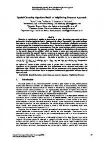
Figure 1: Locations of the matched removal and reference areas in counties Cork, Donegal, Kilkenny and Monaghan in Ireland.
as in [Section 6.3, 4]. The scale at which spatial correlation occurs in each treatment area and county varies considerably. Moreover, as infection rates are relatively low, computational difficulties associated with sparse data arise when data is considered yearly. Therefore, separate spatial models are fitted by area and period. The fixed effects in the models were log(herd size), ph (presence or absence of previous infection in the herd) and the factor year representing the years 1992 to 2002. Models are fitted using the GLIMMIX procedure in the software package SAS version 9.1.3 (SAS Institute Inc., Cary, North Carolina, USA). The significance of the spatial term is assessed by dividing by two the p-value of the Wald statistic of the variance of the random effects referred to a χ 12 distribution [5]. 3. Results Directions were chosen by d ividing the data into quartiles based on the ratio of the x, y co-ordinates (slope) of the herd. Figure 3 shows empirical semi-variograms for the Cork removal area period 0 for the four directions based on the standardised Pearson residuals from the fixed effects logistic model described above. From the figure we conclude there is some directional dependence. Similarly, there was some directional dependence for all areas and periods in all counties. Thus GLGM’s were fitted to the herds
113
114
Gabrielle E. Kelly / Procedia Environmental Sciences 3 (2011) 111–116
Figure 2: Scatterplots of locations of TB infected and non-infected herds in the removal areas of four counties, in the period ಬ97-ಬ02. located in the different direction bands for each period in each area within a county. Estimates and standard errors of practical ranges were determined and are shown in Table 1a,b. In some instances the range estimate was beyond area limits, indicating broad spatial heterogeneity. A range parameter of zero fits equally well in such cases. The test of spatial structure was significant for all directions in all areas and periods (p < 0.001). We note the ranges vary significantly with time within direction and area and vary across counties (Wald tests). Note no models are fitted to the Donegal removal area period 1 because of the low infection rate.
4. Conclusions The results show spatial clustering of TB varies both over time and with direction within an area. This has implications for badger culling policy indicating a single range or direction for culling is not appropriate. Spatial clustering following complete badger removal remains in some directions most likely due to factors other than badgers. We note standard errors attached to spatial ranges are relatively large as sample size is reduced and the number of infected herds is diluted in directional models. The
Gabrielle E. Kelly / Procedia Environmental Sciences 3 (2011) 111–116
subdivision of the data into different directions is somewhat arbitrary. However, if more directions are considered then estimates of the semi-variograms become unreliable due to data sparsity. Further work will explore efficient methods for detecting the direction in which spatial clustering of TB occurs in cattle herds. This may take two forms. Firstly, through statistical detection of spatial clusters. For example, since it is known that the source of some TB infection in cattle is the badger then it may be reasonable to look for spatial clustering in the direction of the nearest badger sett for example. Secondly we may look for clustering in association with important risk factors. Cressie [Chapter 4, 6], noted that anisotropy in one model’s error process cannot be distinguished from nonstationarity in another model’s mean process and there is nonidentifiability of the deterministic and stochastic components of the model described in equations (1)-(4). Thus different models may fit equally well. However, practical conclusions from the models may be similar, as for the Wolfcamp-Aquifer data of Cressie [Chapter 4, 6].
Figure 3. Directional semi-variograms for the Cork removal area period 0 computed using the standardized Pearson residuals derived from the fixed effects logistic models described in the text.
Table 1(a,b). Practical range estimates (s.e.) from logistic generalized linear geostatistical models with exponential covariance structure, described in the text, fitted separately to the removal and reference areas of Counties Cork ,Donegal (Don), Kilkenny (Kilk) and Monaghan (Mon) divided into four subregions (directions) for the pre- (period 0 :1992-1997) and proactive (period 1 :1997-2002) badger culling periods.
115
116
Gabrielle E. Kelly / Procedia Environmental Sciences 3 (2011) 111–116
(a)
Area
Direction
Range (s.e.)
Range (s.e.)
Range (s.e.)
Range (s.e.)
Cork period 0
Cork period 1
Don period 0
Don period 1
removal
1
0.0
0.0
19.7 (5.0)
-
removal
2
2.4 (1.4)
4.5 (3.6)
12.6 (16.0)
-
removal
3
1.8 (1.5)
0.0
0.0
-
removal
4
17.1 (26.3)
6.2 (8.7)
0.0
-
removal
overall
3.56(1.86)
0.18 (0.63)
8.44 (6.97)
-
reference
1
0.0
0.0
2.4 (1.7)
0.0
reference
2
4.2 (7.0)
10.5 (13.4)
0.0
13.0 (18.9)
reference
3
3.7 (2.7)
0.0
0.0
0.0
reference
4
0.0
0.0
-
-
reference
overall
2.87 (1.69)
2.70 (1.05)
0.00
3.00 (1.70)
Direction
Range (s.e.)
Range (s.e.)
Range (s.e.)
Range (s.e.)
(b)
Area
Kilk period 0
Kilk period 1
Mon period 0
Mon period 1
removal
1
0.0
0.0
0.0
2.1 (0.8)
removal
2
0.0
3.2 (2.2)
0.0
0.0
removal
3
2.1 (9.4)
0.0
0.0
0.0
removal
4
0.0
0.0
0.0
0.0
removal
overall
0.0
4.61 (5.40)
0.0
1.89 (0.76)
reference
1
6.9 (12.5)
7.9 (6.9)
6.0 (8.7)
0.0
reference
2
10.0 (17.0)
10.2(19.2)
0.0
4.5 (3.7)
reference
3
0.0
0.0
1.5 (1.2)
0.0
reference
4
0.0
0.0
8.1 (10.1)
0.0
reference
overall
0.0
2.40 (1.18)
0.0
7.61 (4.86)
.
Acknowledgements I would like to thank Guy McGrath of the Centre for Veterinary Epidemiology and Risk Analysis, University College Dublin for geo-referencing and mapping.
References [1] Kelly GE, More SJ. Spatial clustering of TB-infected cattle herds prior to and following proactive badger removal. Epid and Inf In press. Published online October 2010 doi:10.1017/S0950268810002323. [2] Griffin J, Williams D, Kelly G, Clegg T, Collins J. The impact of badger removal on the control of tuberculosis in cattle herds in Ireland. Prev Vet Med 2005; 67: 237-266. [3] Bourne F, Donnelly C, Cox D, Gettinby G, McInerney J, Morrison W. Bovine TB: the scientific evidence. Final report of the Independent Scientific Group on Cattle TB. London:Defra; 2007. [4] Schabenberger O, Gotway CA. Statistical methods for spatial data analysis. Boca Raton Florida: Chapman and Hall/CRC; 2005. [5] Self SG, Liang KY. Asymptotic properties of maximum likelihood estimatos and likelihood ratio tests under nonstandard conditions. J. Am. Statist. Ass. 1987; 82:605-610. [6] Cressie NAC. Statistics for spatial data. New York:Wiley; 1991.