Proceedings, XVII IMEKO World Congress, June 22 – 27, 2003, Dubrovnik, Croatia
TC1
Proceedings, XVII IMEKO World Congress, June 22 – 27, 2003, Dubrovnik, Croatia
TC1
XVII IMEKO World Congress Metrology in the 3rd Millennium June 22−27, 2003, Dubrovnik, Croatia
CELLULAR BASED GPS ERROR CORRECTION SYSTEM Calmin D. Scarlett, Leonardo A. Clarke, Ryan Turner, Joseph Skobla Department of Physics, The University of The West Indies Mona Campus, Kinston 7, Jamaica, West Indies.
Abstract − The Micro-tracking System in development at the Physics Department, University of the West Indies is aimed at providing an effective vehicle and asset tracking system which will cover the entire island of Jamaica. The system uses Global Positioning System (GPS) technology in determining location of an asset equipped with a processing unit which was develop at UWI. We aim to improve this system by increasing the accuracy and efficiency of the system and adding navigational capabilities [1]. This is a cost effective GPS error correction system designed to work with a GSM cellular network. Several factors introduce errors in GPS based positioning calculations. This system is geared towards reducing and/or eliminating these errors and thus increasing the accuracy of the GPS system. This system is able to provide the same services as the Differential GPS (DGPS) systems which are in use today. The DGPS systems use Radio Frequency (RF) transmitters to broadcast error correction information. Our system which uses the existing cellular phone network will eliminate the expensive RF transmitter and the limitations associated with them, thus drastically reducing cost and increase efficiency significantly. Errors in the psuedorange measurements affect the quality of the GPS solution. These errors can be modelled, and by using DGPS techniques the errors can be removed. Neural Networks and Kalman Filters show much potential in implementing an elegant and efficient solution to the problem. Mapping information and software is needed for both tracking and navigation. The paper is describing implementation of a mapping-software which is able to pin point accurately the GPS receiver position on a digital map. This software will also implement a route planning algorithm, which will be able to generate the “shortest path”, whether shortest time or shortest distance, from point A to point B by considering distance, number of turns, traffic lights, traffic congestion and other dynamic information.
1.
INTRODUCTION
The GPS system is a global navigation system set up by the US Department of Defence. It consists of 24 satellites orbiting the earth in 6 planes, three control stations and user receiver equipment. These satellites transmit signals which are received by the GPS receiver. By measuring the time of arrival (TOA) of the signal, the user’s distance (range) from each of the satellite can be calculated. Using the range to a minimum of 4 satellites, the user position can be calculated in three dimensions using the following system of non linear equations:
pi = ( X − X i ) 2 + (Y − Yi ) 2 + ( Z − Z i ) 2
(1)
pi – pseudorange measurement to ith satellite X,Y,Z – user position (unknown) Xi,Yi,Zii – position of the ith satellite Using these equations it is able to provide accurate threedimensional position and velocity information to users anywhere in the world. Accuracies on the order of 10 meters may be anticipated. However the military, operators of the system, can intentionally degrade the accuracy of the C/A signal which is used by civilian users, by desynchronizing the satellite clock and/or by incorporating small errors in the broadcast ephemeris. This degradation is called SA (Selective Availability). With SA the errors incurred by typical civilian users have been found to be 100 m or more. In conjunction with SA, other errors include: ionospheric and tropospheric delay, ephemeris error, satellite clock error, receiver thermal noise, and multipath. A correct method, known as DGPS, (Differential GPS), was implemented by various users of the system in an attempt to eliminate these errors. The DGPS system eliminates SA totally and reduces most of the common errors, thus provides a significant improvement in accuracy. DGPS works by calculating the error experienced by a reference station at a known location. These errors are then applied to user position based on the fact that when the user
Keywords GPS,Cellular Network, Error Correction
83
Proceedings, XVII IMEKO World Congress, June 22 – 27, 2003, Dubrovnik, Croatia Proceedings, XVII IMEKO World Congress, June 22 – 27, 2003, Dubrovnik, Croatia
TC1 TC1
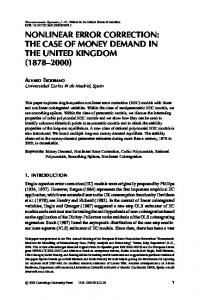
Fig. 1.DGPS principle
The UWI-CBECS also eliminates the need for expensive receivers as it is responsible for making decision on which reference station’s correction data to be used in, or the contribution of each to, the correction of a particular user’s position data. Without expensive receivers, GPS accuracies degrade. A simple civilian GPS receiver can have an average inaccuracy of 35.6 m with SA and 19.2 m without . Jamaica deviates from the average case as there are a lot of mountains in the island. This affects the line of sight needed for an accurate position fix. The weather conditions and the tropical climate also affect the tropospheric and ionospheric delays respectively. For tracking purposes, very accurate GPS solution are necessary, hence the need to do extensive error corrections at the base station. In order to accurately determine a vehicle’s location, or in the more general case, mobile unit, one very important requirement is the availability of a very efficient and accurate mapping system that can be easily referenced. A digitized map can also provide many important features to a vehicle-locating system. One must be able to place a great deal of confidence in the mapping information. However, the method used to develop maps may introduce a level of inaccuracy that is not easily corrected to any great extent therefore some level of inaccuracy is inevitable. As a result various methods must be employed to reduce this level of added uncertainty. The mapping software to be developed will be equipped with information about the degree of error caused by the map and therefore may be used in the proper positioning of the vehicle. Also a fact that can be utilized is that the vehicle generally follows a finite road system therefore the position can be narrowed down to a set of values. This plus other information on the motion of the vehicle can be used to acquire a better fix on the vehicle’s position a technique
and the reference station are close together they experience common errors. DGPS systems have problems associated with them that limit the accuracy they can provide. A number of the problems associated with the DGPS systems can be eliminated while others can be significantly reduced. This paper will introduce a system, The UWI Cellular Based Error Correction System (UWI-CBECS), which is able to reduce and/or eliminate error sources affecting present DGPS systems. The system makes use of the existing cellular infrastructure and incorporates efficient error correction algorithm in an effort to increase accuracy while reducing the implementation and maintenance cost of other error correcting system. In addition to error correction UWI-CBECS incorporates mapping and route planning software which can be used to provide a reliable and accurate navigation and tracking service. 2.
GPS ERROR CORRECTION METHODS
While DGPS achieve very accurate solutions, they have certain problems associated with them. DGPS systems require expensive radio frequency (RF) receivers to transmit correction data which also have to be maintained. DGPS system transmits at low frequency and thus the signal is susceptible to noise from electrical operated equipment. To get the most from a DGPS system the user is required to have receivers which are able to collect position data of the DGPS transmitter so as to be able to select the appropriate correction data to use in its position calculations. The UWI-CBECS as mentioned above uses the existing cellular network and thus eliminates the need for expensive RF transmitters. The cellular system uses high frequency to transmit information that is less susceptible to low frequency noise and thus eliminates errors.
84
Proceedings, XVII IMEKO World Congress, June 22 – 27, 2003, Dubrovnik, Croatia
TC1
Proceedings, XVII IMEKO World Congress, June 22 – 27, 2003, Dubrovnik, Croatia
TC1
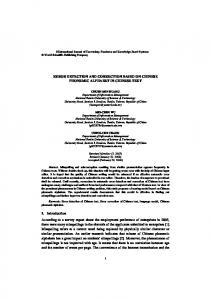
Fig. 2. Block diagram of the UWI system
in correcting the user’s data so as to calculate the user’s most accurate position. The ECA will have to model certain errors that are spatially correlated, that is, errors that get less correlated as the distance is increased from the reference station. One such error is the ionospheric delay. This delay has been found to be equal to:
known as Map-matching. The software also provides routing options that utilizes an effective shortest path algorithm Fig.4. 3.
SYSTEM DESIGN
In this section the design of UWI-CBECS will be presented. The proposed layout of UWI-CBECS is shown below. The system consists of basically four sections: a microcontroller communication and processing unit, an error correction algorithm, a mapping and routing software and a cellular network Fig.2. Any existing cellular network can be used, once it offers a simple messaging service (SMS). The microcontroller communication and processing unit has two sections, a reference station section and a user section. In both sections the unit takes data from a GPS receiver, constructs a SMS message from the data and transmits this SMS message through a cellular modem over a cellular network using the networks SMS service to a base station. The reference stations transmit data (receive position) from a reference station where its exact position is known. The user section transmits data from a user whose exact position is unknown. Data will have transmitted at regular intervals or the reference stations polled depending on how many users require use of the system. The error correction algorithm (ECA) section receives position data from both the reference station unit and user unit. This section knows the exact position of the reference station. It uses this information to calculate the error experienced by the receiver at the reference station and applies it to data received from the user receiver to eliminate the error experienced by the user. The system consists of several reference stations. This section also decides which of the several reference station or the weight of each to be used
Td = (40.3 / f2 ) * TEC • •
TEC = ∫ Ne ds ; integrated density along the signal path from satellite to receiver TEC = f(sunspots, elev.of sat., position of the observation site etc.)
Fig. 3. Klobuchar model
85
(2)
Proceedings, XVII IMEKO World Congress, June 22 – 27, 2003, Dubrovnik, Croatia
TC1
Proceedings, XVII IMEKO World Congress, June 22 – 27, 2003, Dubrovnik, Croatia
TC1
Fig. 4 . Mapping correction
Accuracy of position is increased by using error correction algorithm, map correction algorithm and making decisions on the reference station data which is to be used in correction calculation at the base station.
Models exist that attempt to model this delay. One such model is the Klobuchar’s model [2]. The model gives a constant delay of 5ns at night and is approximated by a cosine function in the day in addition to the constant night-time delay Fig.3. All models for the various errors will have to be integrated. Neural networks and/or Kalman Filter is being explored as a means of achieving this task. The mapping software section takes input from the error correction algorithm section. Using this information it is able to place the user accurately on a map. This section also implements a map correction algorithm which increases the accuracy of incorrect maps using an error correction file. When the corrected user position is received it will look in the file for the closest map correction to that position and apply it. This section also implements a route planning algorithm which is able to find the shortest route from one place to another. Variables such as Traffic congestion, the number of stop lights etcetera are going to affect the decision as to which route is the shortest route.
REFERENCES [1] [2] [3]
[4] [5] [6]
4. CONCLUSION The UWI-CBECS is an efficient and cost effective GPS error correction system. It eliminates the use of RF transmitters, which are expensive, and thus also eliminates the cost associated with set up and maintaining broadcast sites. The use of expensive DGPS receivers are also not necessary which further reduces cost. The problem of noise associated with low frequency transmission is also eliminated by using the high frequency cellular network to transmit information.
Skobla,J. and A.Young, “Robust GPS –SMS Communication Channel for the AVL System”, Proceedings of Aerospace Conference, IEEE,2003. Grewal,M.S., “ Global Positioning Systems, Inertial Navigation and Integration”, Wiley, 2001. Taylor G. et al. “Virtual DGPS and road reduction filtering”. Proceedings of ION’9912th International Technical Meeting of the Satellite Division of the ION, 1999. Kaplan Elliott D. “Understanding GPS Principles and Applications”. Artech House, Inc., 1996. Zhao Yilin, “Vehicle Location and Navigation Systems”. Artech House, Inc., 1997. Se-Chul Chu et al. “New Approach on The Improvement of DGPS Positioning Accuracy Using the RLSLFs and a Kalman Filter”. Dept. of Electronics Engineering, Kook-Min University, Korea Research Institute of Standards and Science, 2000.
Authors: Calmin D. Scarlett, Leonardo A. Clarke, Ryan Turner and Dr.Joseph Skobla, The University of The West Indies, Physics Department, Kingston 6, Jamaica, phone: 876 927 2480,
[email protected]
86