Deterministic Rainfall Induced Landslide Approaches, Advantage and Limitation Mehrdad Safaei Mountainous Terrain Development Research Center Department of Civil Engineering and Faculty of Engineering, University Putra Malaysia 43400 Serdang, Selangor, Malaysia e-mail:
[email protected]
Husaini Omar Mountainous Terrain Development Research Center Department of Civil Engineering and Faculty of Engineering, University Putra Malaysia 43400 Serdang, Selangor, Malaysia e-mail:
[email protected]
Bujang K Huat Mountainous Terrain Development Research Center Department of Civil Engineering and Faculty of Engineering, University Putra Malaysia 43400 Serdang, Selangor, Malaysia e-mail:
[email protected]
Zenoddin B M Yousof Mountainous Terrain Development Research Center Department of Civil Engineering and Faculty of Engineering, University Putra Malaysia 43400 Serdang, Selangor, Malaysia e-mail:
[email protected]
Vahed Ghiasi Mountainous Terrain Development Research Center Department of Civil Engineering and Faculty of Engineering, University Putra Malaysia 43400 Serdang, Selangor, Malaysia e-mail:
[email protected]
ABSTRACT There are many approaches to assessing slope stability for landslide susceptibility and hazard mapping that mostly running in GIS platform by define a spatial extension with less error or more successes rate and availability of predictive landslide modeling. These models can be classified into four main methods: inventory, heuristic, statistic and deterministic. Recent studies have shown that the best approaches for landslide spatial prediction is the application of deterministic slope stability models, combined with steady state or transient models for hill slope hydrology. These may provide scenarios of potential instability under changing environmental and climatic conditions but are very data demanding at watershed scales. Several authors have developed GIS models by coupling a dynamic hydrological model that simulates the pore pressure over time with a slope stability model that quantifies the susceptibility as the critical pore pressure threshold. Therefore, those require with simplification of the landslides type and depth. The geotechnical model, which is deterministic or probabilistic, has been widely employed in civil engineering and engineering geology for slope stability analysis. A deterministic approach was traditionally considered sufficient for both homogenous and non-homogenous slopes. Calculating the safety factor requires geometrical data and information on the pore water pressure and ground water table. Base on literature review, there is some lack of a systematic comparison of different techniques in order to outline advantages and limitations of the methods to model the spatial distribution of landslides. We can use deterministic approaches for rainfall, and earthquake induced landslide or landslide run out modeling.
KEYWORDS: Landslide, Rainfall, Deterministic, Susceptibility. - 1619 -
Vol. 16 [2011], Bund. U
1620
INTRODUCTION Landslide or mass movement is a phenomenon of the denudation process, where by soil or rock is displaced along the slope by mainly gravitational forces, usually occurring on unstable slopes due to various reasons. The reasons can be either natural or man-made. Landslides occur in all geographic regions of the world in response to a wide variety of natural conditions and triggering processes that include storms, earthquakes, and human activity. It is very important to map the landslide potential of mountain area, to assure the safety of the people delineate the suitable land for development. In recent years the assessment of landslide hazard and risk has become a topic of major interest for both geoscientists and engineering professionals as well as for the community and the local administrations in many parts of the world (Aleotti and Chowdury, 1999). On average, landslides are responsible for 17% of all fatalities from natural hazards worldwide (Cred, 2006). In total, more than 500 000 people were killed by landslides in the 20th Century. The majority of those fatalities occurred in mountainous areas within less-developed countries. In the first 25 weeks of 2003 alone there were nearly 2000 landslide fatalities in 139 large events, 95% of which occurred in less-developed countries. A more detailed study in Nepal recorded 55 fatalities in 2000, 185 fatalities in 2001 and 345 fatalities in 2002, reflecting a rising trend in landslide impacts worldwide, a trend that is exacerbated by climate change, population pressure and increased road construction. The economic costs are harder to quantify, but certainly exceed $10 billion per annum; with remote rural communities being particularly affected. Best estimates suggest that in the last 20 years, 120,000 people were killed and an economic loss of $200 billion was caused by landslides (Leroi, 1996). In order to mitigate losses caused by landslides, many landslide susceptibility mapping approaches have been developed and tested (Carrara, 1988; Van Westen et al., 1993; Aleotti et al., 1999; Guzzetti et al., 1999; Dai et al., 2002; Carrara and Pike, 2008; Alexander, 2008). These methods pose complex problems and difficulties for rate and reliability of spatial prediction. However, all the available methods for regional landslide susceptibility assessments have some uncertainties due to a lack of knowledge and variability for input and output parameters. Recent studies have shown that the best approaches for spatial prediction landslide is the application of deterministic slope stability models, combined with steady state or transient models for hill slope hydrology. These may provide scenarios of potential instability under varying environmental and climatic conditions (Van Beek, 2002), but are very data demanding over larger areas and require a substantial degree of simplification of the landslide types and depths (Van Westen et al, 2005). The motivation for this study is to develop slope stability analysis for deep-seated landslide by using ArcGIS spatial analyst. Landslide hazard maps are widely used in resource development planning and in planning linear projects such as roads, railways, pipelines and transmission lines. Landslide hazard is the probability of the occurrence of a potentially damaging landslide within a certain period within a given area (Varnes, 1984). The probability of a landslide event is the likelihood that a mass movement (or slope failure) will occur. It can be expressed in relative (qualitative) terms or probabilistic (quantitative) terms. Probability can refer to the probability of occurrence within a certain period, or to the probability caused by the uncertainty of geotechnical parameters or geotechnical models, or the frequency, intensity and duration of triggering agents (Chowdhury and Flentje, 2002). There are many approaches to assessing slope stability and landslide hazards (Sidle et al., 1985; Dietrich et al., 1986; Montgomery and Dietrich, 1988; Dietrich et al., 1992; Sidle, 1992; Dietrich et al., 1993; Montgomery and Dietrich, 1994; Wu and Sidle, 1995; Pack, 1995). The most widely used include (Montgomery and Dietrich, 1994): (A) field inspection using a checklist to identify sites susceptible to landslides; (B) projection of future patterns of instability from analysis of landslide - 1620 -
Vol. 16 [2011], Bund. U
1621
inventories; (C) multivariate analysis of characterizing observed sites of slope instability; (D) stability ranking based on criteria as slope, litho logy, land form, or geologic structure; and (E) failure probability analysis on slope stability models with stochastic hydrologic simulations. Each of approaches is valuable certain applications (Pack et al., 2001). In recent years, numerous Geographic Information System (GIS)-based applications have been developed to assess slope stability (Lee et al., 2004; Ohlmacher and Davis, 2003; Zhou et al., 2003; Dai and Lee, 2002; Atkinson and Massari, 1998). GIS slope stability models can be classified into four main methods: inventory, heuristic, statistic and deterministic. However, based on recent studies of GIS applications to model landslide susceptibility, it is established that models need to be improved to build the prediction maps rather more helpful and suitable for engineers, policy-makers, and developers choosing appropriate locations to carry out hazard mitigation (Xie and Xia, 2004) and also developing new models by defined spatial extension in ArcGIS platform with less error or successes rate and availability of predictive landslide modeling. The geotechnical model, which is deterministic or probabilistic, has been widely employed in civil engineering and engineering geology for slope stability analysis. A deterministic approach was traditionally considered sufficient for both homogenous and non-homogenous slopes. The index of stability is a well-known safety factor, based on an appropriate geotechnical model and on the physical mechanical parameters. Calculating the safety factor requires geometrical data, data on the shear strength parameters and information on pore water pressure.
LANDSLIDE SUSCEPTIBILITY MAPPING Landslide Susceptibility is a quantitative or qualitative assessment of the classification, volume (or area), and spatial distribution of landslides, which exist or potentially may occur in an area. Susceptibility may also include a description of the velocity and intensity of the existing or potential land sliding. Although it is expected that land sliding will occur more frequently in the most prone areas, in the susceptibility analysis, time-frame is explicitly not taken into account. Landslide susceptibility includes landslides, which have their source in the area, or may have their source outside the area but may travel onto or regress into the area.
Table1: Types of the landslides mapping and definition Types of the landslide's mapping
Definition
Landslides inventory map
- Location and characteristics of existing landslides
Landslides susceptibility map
Location and characteristics of potencial landslides Which areas with a potential to experience landsliding in the future.
Landslides hazard map
Estimated temporal frequency (annual probability) Intensity – frequency relationships
Landslides risk map
Estimated of the probability of the occurrence and the probability of the consequence.
- 1621 -
Vol. 16 [2011], Bund. U
1622
Table 2: Landslide zoning mapping scales and their application Scale description
Indicative range of scales
Small
1:5,000
Examples of Zoning application Landslide inventory and susceptibility to inform policy makers and the general public Landslide inventory and susceptibility zoning for regional and local development; or very large scale engineering projects. Preliminary level hazard mapping for local areas Landslide inventory, susceptibility and hazard zoning for local areas. Preliminary level risk zoning for local areas. And advanced stages of planning for large engineering structures , roads and railways Intermediate and advanced level hazard and risk zoning for local and site specific areas and for the design phase of large engineering structures ,roads and railways
Typical Area of zoning >10,000 square kilometers 1,000 to 10,0000 square kilometers
10 to 1,000 square kilometers
Several hectares to 10 square kilometers
Landslide susceptibility and hazard mapping have been the development during last few decades. Most of these mapping studies are qualitative in nature, although more recently there have been examples of quantifying the hazard by assigning an annual probability (frequency) to the potential landslides and quantifying the risks for existing development (Corominas, 2008). Landslide susceptibility methods can be classified into four main approaches: inventory, heuristic, statistic, and deterministic (Metternicht et al., 2005; Zhou et al., 2003; Dai et al., 2002; Clerici et al., 2002). Each type has advantages and limitations for regionalization of probability of land sliding. A review of recent publications indicates that mostly, the statistically-based susceptibility approaches have been used for landslide predictive modeling (Van Westen, 1993; Chung et al, 1995; Bonham-Carter, 1996; Davis and Keller, 1997; Binaghi et al., 1998; Atkinson and Massari, 1998; Chung and Fabbri, 1999; Chung and Fabbri, 1993, 1999; Dai et al., 2001; Lee et al., 2002,2004; Suzen and Doyuran, 2004; Van Westen et al., 2003; Ohlmacher and Davis, 2003; Dai and Lee, 2003). The statistical approach does not propose mechanisms that control slope failure and do not have a mechanical meaning, but rather it assumes that the prediction of future landslide areas can be assessed by measuring the combinations of variables that have led to landslide occurrence in the past (Lee et al., 2004; Zhou et al., 2003; Ohlmacher and Davis, 2003. Multivariate statistical analysis (such as logistic regression analysis) attempts to overcome the qualitative weaknesses of judgment based manual mapping by correlating terrain attributes with landslide occurrence to estimate the landslide propensity in locations with similar terrain (Carrera, 1983; Carrera et al., 1991; Carrera et al., 1995). This approach, though more quantitative than manual mapping, is empirical in nature and hence there are limitations to extrapolation beyond the study region (Dietrich et al., 2001). In deterministic analysis, the landslide hazard is determined using slope stability models, resulting in the calculation of factors of safety. Deterministic models provide the best quantitative information on landslide hazard that can be used directly in the design of engineering works, or in the quantification of risk. However, they require a large amount of detailed input data, derived from laboratory tests and field measurements, and can therefore, only are applied over small areas at large scales (Van Westen, 2004). Comparison of Four types of main approaches for landslide susceptibility mapping shows that there are meaningful differences between of landslide susceptibility methods (Long, 2008). In his study in the Western part of Thua Thien Hue province, Vietnam mentioned that among different types of landslide susceptibility approaches, the certainty factor is the best method because this method had most accurately for detection landslide prone areas (Long, 2008). - 1622 -
Voll. 16 [2011], Bund. U
1623
Figure 1: Classificcation of lanndslide suscceptibility assessment a approaches a (Safaei et al; a 2010)
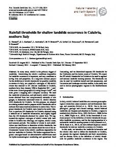
DETE ERMINIS STIC APPROACHES Deteerministic slope stabilityy models neeed a soil thicckness, soil strength, grooundwater pressures, p slope geeometry ,etc. as an inpuut parameter or calculatiion average factor of saafety and creeated the susceptibbility relativ ve hazard map m based on n factor f saafety ranges as a main output. o Deteerministic models ccalculate sloppe instabilityy in one, twoo or three dim mensions (Teerlien et al., 1995). 1 Galanng (2004) used onee-dimensionaal infinite sloope model (B Bolt et al., 1975) to calcu ulate instability at each pixel p and also, Sloope profiles are a analyzedd in two-dimeensional moddels, and the entire landslide body is analyzed in three--dimensional models. Siimilarly, hyddrological models m can fuurther more be one, two or three dimensioon models; however, h prooblems exist for both sloope instabilitty and hydroological models when using thhree dimensioons in the coonventional two-dimensiional GIS (T Terlien et al., 1995). For two and three-dim mensional in nstability moodels, the prooblem is ofteen the compllexity of the calculations whereas the hydrrological mo odels have prroblems convverting threee-dimensionaal output maaps into form ms usable in GIS ccalculations (Galang, ( 20004). Vann Westen (1997) shownn a schematiic overview of the use of determin nistic slope stability methodss in a GIS is presented in Figure 3.1. - 1623 -
Vol. 16 [2011], Bund. U
1624
Figure 2: Representation for application of GIS in deterministic slope stability Xie et al (2004) purposed a three-dimensional GIS-based deterministic modeling to calculating average safety factors regarding to different soil layers. Furthermore, Qui et al (2007) have been developed a new GIS-based 3D model by incorporating an infiltration model and taking account of - 1624 -
Vol. 16 [2011], Bund. U
1625
geo mechanical changes of soil strength during rainfall in the calculation. Of course, there are some difficulties for applicability of 3D deterministic models such as (1) the difficulties in creating continuously distributed data for topography, strata and groundwater through limited investigations; (2) processing a vast amount of complex information about the natural topography and geology; and (3) determining the location and the shape of an unknown failure surface (Qiu et al., 2007). The spatial distribution of the input data requires deterministic distributed model's maps. Savage et al. (2004) and Baum et al. (2005) have been mentioned that the variability of input data can be further used to calculate a probability of failure in combination with return periods of triggering factors. The main problem with these methods is the oversimplification of the geological and geotechnical model, and difficulties in predicting groundwater pore pressures and their relationship to rainfall and/or snow melted. The main output of this approach is the susceptibility map that predicted the landslide prone areas by using a stability index. Local models are usually much more accurate because they analyze the stability of a single slope by detailed hydrological, hydraulic and geotechnical information (capparelli et al., 2008). Terlien et al., 1995; Gritzner et al., 2001; Chen and Lee, 2003 developed a dynamic-hydrological model for calculation the pore water pressure over time together a slope stability analysis and Van Beek and Van Asch (2004) developed a model that couples a distributed hydrological model with a probabilistic assessment of slope stability using PCRaster program to predict landslide under land-use changes. Furthermore, the deterministic approaches for earthquake-induced landslide hazard analysis are based on the simplified Newmark's slope stability model, applied on a pixel by- pixel basis, which can be carried out completely within the current GIS computational environments (Miles and Ho, 1999; Luzi et al., 2000; Randall et al., 2000; Jibson et al., 2000). Refice and Capolongo (2002) have implemented a Monte Carlo simulation in combination with the N model (Van Westen, 2004). Deterministic landslide runs out modeling developed by Dymond et al., (1999) for run out shallow landslide to the stream network. Recently, the availability of digital elevation model (DEM) data has induced the development of approaches that obtain the advantage of GIS platform to quantify topography attributes related to sloping instability in watershed areas. Moreover, International Institute for Aerospace Survey and Earth Sciences (ITC) has developed a GIS called the Integrated Land and Water Information System (ILWIS) that have modules incorporated in the GIS for deterministic instability zonation (Van Westen, 1997). GIS based slope stability reviews for this research utilize the infinite slope stability model in ArcGIS Spatial Analyst. The input data for the models reviewed include DEM data as well as the field geotechnical data-slope angle, cohesion, internal friction angle, soil density and the ground water depth. The highlights of common GIS based slope stability models developed by Wu and Sidle, 1995; Montgomery and Dietrich, 1994; Shaw and Jonson, 1995; Pack et al., 1998)
Different deterministic approaches Several researchers have been purposed different deterministic approaches based on an infinite slope stability model with rainfall infiltration models (Montgomery and Dietrich, 1994; Dietrich et al., 1995; Terlien et al., 1995, Dymond et al., 1999; Crosta and Dal Negro, 2003). Usually, a physically based model, including a coupled hydrological model (for soil moisture and pure water pressure under different simplification and assumption) and a slope stability model, along with an impact model, such as basin sediment yield. These models are used two main group hydrological simulation, Including:
- 1625 -
Vol. 16 [2011], Bund. U
1626
A. Hydrological simplified distributed models: In this group, Hydrology is limited to a steady-state description of subsurface flows and these models are fundamentally unable to predict the timing of the occurrence of failure (temporal prediction) such as SHALSTAB model (Montgomery and Dietrich, 1994) and SINMAP model (Pack and Tarboton, 1998).
B. hydrological dynamic models: Dynamic or Real time distributed model accounting for transient infiltration and soil moisture redistribution that these models integrate meteorological and earth observation data, e.g. CHASM (Wilkinson et al., 2002), TRIGRS (Baum et al., 2002, 2004), dSLAM /IDSSM (Wu and Sidle, 2004), GEOtop-FS (Simoni et al., 2008). In addition, the empirical methods can be used for assessing variables, which are hardly determined by deterministic methods and numerical simulating.
Table 3: Review of most of deterministic approaches used at watershed scale by researchers. Deterministic approaches
Description
Researcher
Date
Combined Hydrology And Stability Model
(Anderson and Lloyd, 1991; Anderson et al., 1996)
1991
LISA
Level I Stability Analysis
Hammond et al
1992
SHALSTAB
Shallow Landsliding Stability Model
Montgomery and Dietrich (1994,1998)
1994
SMORPH
Slope MORPHology
Shaw and Johnson (1995)
1995
dSLAM/IDSSM
Distributed Shallow Landslide Model/Integrated Dynamic Slope Stability Shallow Landslide Model
Wu and Sidle(1997)
1997
SINMAP
Stability Index Mapping
Pack et al.,(1998,2001)
1998
System Hydrology European TRANsport
Ewen et al.,2000 Birkinshaw et al., 2010
2000
TRIGRS (Iverson’s model)
The Transient Rainfall Infiltration and Gridbased Regional Slope-stability
Iverson(2000) and extended by Baum et al. (2002)
2000, 2002
PROBSTAB
PROBability of STABility PCRaster GIS package
Van Beek (2002)
2002
TRIGRSunsaturated
The Transient Rainfall Infiltration and Gridbased Regional Slope-stability
Savage et al.,2004
PISA
Probabilistic infinite slope analysis.
Haneberg(2004)
CHASM
SHETRAN
- 1626 -
2004 2004, 2005
Vol. 16 [2011], Bund. U
1627
GEOtop-FS
combines the hydrological distributed model GEOtop (Bertoldi et al. 2006) and an infinite slope geotechnical model
SUSHI
(Saturated Unsaturated Simulation for Hillslope Instability) model
Simoni et al.,2007
2007
Capparelli et al.,2006
2006, 2007
As mentioned in table 3, the several deterministically based models can be used for predicting rainfall induced shallow landslides such as The Level I Stability Analysis (LISA; Hammond et al., 1992) Shallow landslide stability model (SHALSTAB; Montgomery and Dietrich., 1994 ) Stability Index Mapping (SINMAP; Pack et al., 1998), Transient Rainfall Infiltration and Grid based Regional Slope Stability (TRIGRS; Iverson., 2000 and Baum et al., 2002) Storage and Redistribution of Water in Agricultural and Re-vegetated Slopes coupled with Probability of Stability (STARWARS/PROBSTAB; van Beek, 2002) and currently GEOtop-FS (Simoni et al., 2008). Based on literature review some of the used deterministic approaches at watershed scale are briefly describe as follows:
Shallow landslide stability model (SHALSTAB) The SHALSTAB model (Montgomery and Dietrich, 1994; Montgomery et al., 1998; Dietrich et al., 2001) is a physically based model, including the steady-state hydrologic model (O'Loughlin, 1986) for prediction shallow subsurface flow with an infinite slope stability equation using the MohrCoulomb failure criteria (Bolt et al., 1975), for the prediction of shallow slope instabilities based upon the minimum amount of steady-state rainfall required to trigger land sliding (or critical rainfall). SHALSTAB was developed for ‘hilly’ terrain and may not be suitable for steeper slopes or mountainous terrain (Dietrich et al., 1998). This model calculates relative wetness based on steadystate saturated water flow parallel to the slope plane. =
sin
[1]
=
where, in the equation [1], “W” is relative wetness or relative saturation of soil. a is drainage area or contribution area , and b is width of outflow boundary or topographic contour length qc is effective precipitation; T is transmisivity of soil, θ is local slope
- 1627 -
Vol. 16 [2011], Bund. U
1628
Figure 3: The parameters used in the program TOPOG (O’Loughlin, 1986) to calculate relative wetness Also can write based on Darcy’s law;
.
ℎ cos sin
=
sin
[2]
cos sin
=
[3]
where “k” is saturated hydraulic conductivity of soil, SHALSTAB also uses h/z parameter thus as a result from equation [2] and [3] we can write the equation [4];
[4]
W= =
where h is the thickness of the saturated soil above the impermeable layer and z is the total thickness of the soil. If the SHALSTAB is solved one dimentional infinte slope stability equation under mohr-cloumb criteria in terms of the hydrologic ratio(q/T) and QC (the critical steady state neccesarry to trigger failure) to classified relative slope stability . for the case of coehsionless ( C/=0), can be experssed as:
=
1−
tan tan
[5]
which can also be written as
= =
1− 1−
tan tan
tan tan
sin /
[6]
sin /
[7]
where qc is critical rainfall for shallow failure initiated, ρ is soil bulk density, ρ density and φ is angle of internal friction of the soil mass at the failure plane,
- 1628 -
is water bulk
Vol. 16 [2011], Bund. U
1629
Because q/T is always